Apple has acquired Coherent Navigation, according to various media reports.
Coherent Navigation is a Bay Area GPS firm founded in 2008 by engineers from Stanford and Cornell. One of its areas of focus was high-integrity GPS (iGPS), an enhanced version of GPS that uses both normal, high-altitude GPS satellites and lower-altitude voice and data satellites from Iridium to increase the accuracy of a consumer’s GPS reading from the ground.
The acquisition seems to be Apple’s latest efforts to bolster its mapping capabilities.
The Boeing Company has been awarded a $153.5 million U.S. Naval Research Laboratory contract to demonstrate High Integrity Global Positioning System (GPS) technology concepts. The contract is expected to run through 2010.
The High Integrity GPS effort combines satellite signals from the Iridium Low Earth Orbit telecommunications system and GPS Mid Earth Orbit navigational satellites to enhance navigation availability, integrity, accuracy, and jam-resistant capabilities for warfighters.
“High Integrity GPS is an effective near-term tool that will augment GPS satellites to provide critical new capabilities, including aggressive levels of additional anti-jam protection,” said David Whelan, Boeing Integrated Defense Systems chief scientist and vice president/deputy general manager, Advanced Systems. “Our research concluded that significant low-cost improvements to GPS can be achieved by using existing signal platforms and systems such as the Iridium constellation.”
The need to provide a more capable GPS for warfighters stems from the increasing sophistication of hostile jamming capabilities, according to Boeing. GPS supports numerous military and civil applications, so the ability to jam the system presents a grave threat, the company said.
“Boeing has been working over the years to find new ways to maximize the effectiveness of the GPS constellation,” said Alex Lopez, vice president, Advanced Network and Space Systems. “With this integrated approach, we can increase the value of the current system by improving its operational mission-assurance capabilities.”
Based on its years of experience supporting the operation of the Iridium system, Boeing is able to integrate the system with GPS in a manner to create the first such combined navigation and communication “system-of-systems,” the company claimed.
The High Integrity GPS team includes Boeing Advanced Systems and Phantom Works, Iridium LLC, Rockwell Collins, Coherent Navigation, and experts from academia.
Iridium Satellite LLC, headquartered in Bethesda, Md., operates the Iridium constellation to provide worldwide voice and data satellite communications services for the private sector and the U.S. government. Boeing has provided Iridium with systems engineering and constellation management functions since the system became operational in 2000.
Phantom Works is the advanced research and development unit of Boeing. Its charter is to provide innovative technology solutions that reduce cycle time and cost of aerospace products and services while improving their quality and performance.
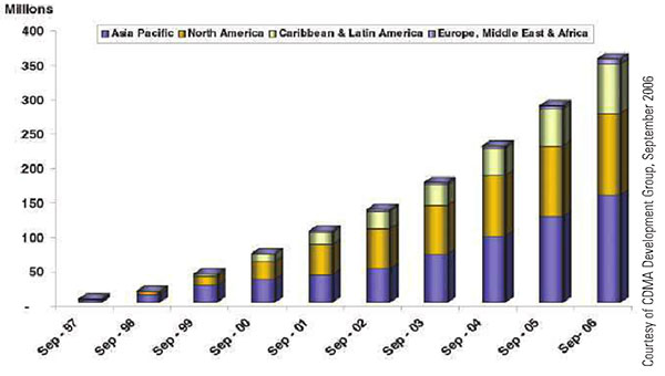
Figure 1. Global CDMA subscribers. CDMA cellular infrastructure uses GPS for synchronization and optimal performance. Location-based billing will require GNSS integrity.
By Vidal Ashkenazi
The use of satellite navigation in civil aviation and other safety-critical navigation applications drove the development of satellite-based augmentation systems and differential networks to track and augment GPS, providing the prerequisite levels of accuracy, integrity, coverage, and availability. Deployment and operation of Galileo — independent, compatible, and interoperable with GPS — will significantly add to the levels of accuracy, coverage, and system integrity.
Meanwhile, safety-critical transportation is no longer the only critical application considered for satellite navigation and positioning. New and developing financial-critical, business-critical, security-critical, legal-critical and government- policy-critical applications demand levels of coverage, integrity, and availability matching those of safety-critical transportation.
Consider road user charging (RUC) proposed by the British government to replace the current fixed annual road tax, which only depends on a vehicle’s size and pollution rating. RUC is based on taxing a car owner who drives only on country roads less than another driver who uses city centers and motorways, often during rush hours, contributing to traffic jams and pollution. It would be fairer if road taxing were based on when, where, and how you drive. The same principles also apply to car insurance and city-center congestion charging.
So far, all seems straightforward. But consider that with direct telematic links to individual bank accounts, these charges could be debited automatically, or invoiced and debited like monthly utility bills. Once money is involved, the operation becomes financially-critical. There is a need to demonstrate that such charges not only have high accuracy and integrity, but that they are “correct, beyond all reasonable doubt”.
As a scientist and an engineer, I have always used the terms “statistical levels of accuracy and integrity.” This is the first time in my scientific life that I have to use that statistically meaningless, unspeakable term “correct”, which implies 100 percent of certainty. GNSS, this is your challenge!
The same is true of the timing of stock exchange transactions and location-based billing via mobile phones. As the levels of accuracy, coverage and integrity of GNSS improve, so will the credibility of satellite positioning as a highly accurate, reliable tool for economically-critical applications.
It is difficult to distinguish between security-critical and legal-critical navigation and positioning applications. Both types will require very high levels of accuracy, coverage, and integrity, but most applications that start as security-critical may end up in a court of law and become legal-critical. Examples include tracking precious or hazardous cargos, tracking suspected individuals or criminals released on parole, the location of suspect mobile phone calls, and the positioning of fishing vessels inside territorial waters.
Lastly, many government/policy-critical navigation applications connected with police, fire and ambulance services, national security, and emergencies will require secure/encrypted GNSS signals. In the United States, where GPS is directed by the PNT Executive Committee, co-chaired by the DoD and the DoT, this should not present a problem, because the system is considered a fully dual military-civilian navigation tool. This is not the case in Europe, which has yet to define the framework for governance and use of the Public Regulated Service within EU member states, and the status of non-EU states proposing to collaborate on Galileo.
VIDAL ASHKENAZI is CEO of Nottingham Scientific Ltd., a UK-based company involved in Galileo since its earliest phase. He is a charter member of GPS World’s Editorial Advisory Board since 1990. This article is excerpted from his keynote address at IAIN World Congress 2006 held in Korea.