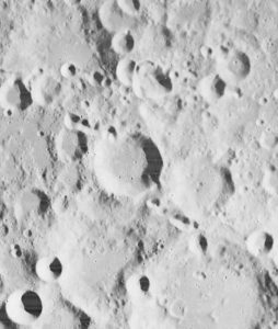
I was inspired by the 50th anniversary of the Moon landing on July 16 and our focus on mapping this month to look into imagery of the Moon.
Only recently have we learned that the lunar orbiters that photographed the Moon in the 1960s sent back images that were stunningly high resolution (HR), even by today’s standards. The actual resolution was presumably kept secret because the imaging technology was also used in our Cold War spy satellites.
Under the Lunar Orbiter Program, satellites took photographs of the Moon’s surface to identify suitable landing sites for the Apollo Program. Managed by the Langley Research Center, five Lunar Orbiters were successfully flown in 1966 and 1967, mapping 99% of the Moon’s surface with a resolution of 60 meters or better.
The first three missions were dedicated to imaging 20 potential landing sites, and were flown at low-inclination orbits.
The fourth and fifth missions were devoted to broader scientific objectives and were flown in high-altitude polar orbits. Lunar Orbiter 4 photographed the entire nearside and 95% of the farside, and Lunar Orbiter 5 completed the farside coverage and acquired medium (20-meter) and high (2-meter) resolution images of 36 pre-selected areas.
In that pre-digital era, the Lunar Orbiters had an ingenious imaging system, which consisted of a dual-lens camera, a film processing unit, a readout scanner and film-handling apparatus. Both lenses, a 610-mm narrow angle HR lens and an 80-mm wide-angle medium resolution (MR) lens, placed their frame exposures on a single roll of 70-mm film.
The axes of the two cameras were coincident so the area imaged in the HR frames were centered within the MR frame areas.
The film was moved during exposure to compensate for spacecraft velocity, which was estimated by an electric-optical sensor. The film was then processed, scanned, and the images transmitted back to Earth. Based on these images, the NASA Apollo Site Selection Board would name five candidate landing sites in February 1968.
An oblique image of downtown Chicago, captured in June 2017, with measurements. (Image: Nearmap)
Guest column by Sanchit Agarwal Vice President, Field Operations, Nearmap
With high-resolution imagery comes the ability to model reality, creating real-life visualizations for engineers, planners, construction teams and many others.
A quantum leap in computing capacity has allowed us to model and analyze the real world — all from our desktop and mobile devices. In days past, maps were purely for visualization and direction.
Today, they have graduated to full-blown analytics platforms empowering users to make decisions faster than ever before.
Why?
They closely represent truth on the ground — truth created from high-resolution aerial imagery captured at heights of up to 18,000 feet. Camera systems mounted in the bellies of planes can efficiently map the real world in incredible high detail. These aerial photographs are updated continuously.
In years past, access to aerial mapping content and services was reserved for more significant players.
Today, with easy access to scalable high-definition mapping content, anyone can utilize the power of maps in applications that extend far beyond directions and navigation.
There are two essential attributes of aerial maps driving this transformation — image resolution and model density. Today, most users are applying low-resolution satellite images that lack the detail needed for accurate decisions. But, as resolution increases, the imagery becomes more detailed; the visualizations, more vivid.
Ground features have gone from fuzzy satellite photos to clearly identifiable homes, buildings, roads, lakes and more — all captured using powerful cameras that have found the perfect pixel. With high-resolution comes added benefit.
Aerial image of the Aria Resort in Las Vegas captured in May 2017. (Image: Nearmap)
Users can manipulate the imagery — zoom closer and closer without losing the details. Computers can classify the features, distinguishing skylights from solar panels, walking paths from sidewalks, and pools from ponds.
Rich imagery is yielding richer data used to instantly query massive databases and return results that answer complex questions for businesses and government.
With high-resolution imagery comes the ability to model reality, creating real-life visualizations for engineers, planners, construction teams and others.
These models of landscapes, cities and neighborhoods are portrayed inside design tools and mapping systems, saving the analyst countless days of traveling to the site only to be surprised that the outdated low-resolution imagery does not depict what’s actually on the ground.
Imagery can vary greatly in resolution. Pixel resolution refers to the actual distance on the ground that each pixel represents in the orthophotography — the vertical image. For example, one-foot pixel resolution means that each pixel in the image covers one foot on the ground.
Common resolutions include three-inch, six-inch, one-foot and one-meter. The higher the imagery resolution (for instance, three inches per pixel), the greater the visible detail within the photograph. Clearly, a three-inch resolution is much better than a one-foot resolution.
Most mapping content currently consumed is two-dimensional and generated from low to mid-resolution nadir imagery. In other words, you see the land as if you were staring straight down at it, not height-of-ground features and certainly not change over time.
While that was adequate for some users, others reached for higher resolution and, while they were at it, decided they needed a third and fourth dimension — namely, height and time. These new perspectives provide more analytical options, more insights and a variety of new use cases that show change over time, height and multi-perspectives of the same property or landscape.
With the democratization of mapping products and services and the general trend toward consumption of multi-dimensional experiences, there is an implicit need to increase resolution, detail, dimensions and perspectives in mapping content and services as well.
The Rancho Mirage community of California, captured in February 2017. (Image: Nearmap)
Traditionally, satellite imagery has been used to monitor large areas of the earth at scale remotely. The resolution of the satellite imagery has graduated from multiple meters to feet with the advent of advanced mapping satellites.
The challenge here is the resolution. Low-resolution satellite imagery, although scalable, is good for macro-analysis of cities and neighborhoods but is not detailed enough for accurate measurements and micro-analysis at the level of each individual property.
On the other end of the spectrum come drone mapping solutions that offer the promise of delivering incredibly high-resolution datasets (sub-centimeter resolution) but fails to provide the scalability and repeatability.
Let’s get specific. Why does resolution matter?
You cannot measure what you cannot see. The resolution of imagery provides a more detailed, zoomed in and richer view of the real world, thereby enabling desktop based reconnaissance, inspection, analysis and measurement of features that are not traditionally visible in satellite imagery.
Higher resolution means high fidelity and dependable measurements. With the added details and definition of features that high-resolution offers comes the much-needed advantage of clearly and legibly identifying feature boundaries and hence measuring the feature with high precision and accuracy.
Higher resolution map content means fewer site visits. Rather than travel onsite to inspect and measure, many organizations are now relying on high-resolution imagery and, in the process, not having to waste resources sending team members on site.
High resolution means more detailed documentation of reality. Gamers have experienced reality-like landscapes for quite some time. Now, 3D and 4D mapping content allows users to immerse themselves in the landscape, navigate through street views, and fly like a bird to inspect rooftops with ease.
High resolution and refreshed content means more accurate change analysis. Identifying how locations have changed over time through multiple captures that embody leaf-off and leaf-on imagery allow users to not only visualize detail but also notice progress, changes in construction, degradation of property features, growth in vegetation and more.
High-resolution content means more automated workflows. High-resolution content allows for better feature definition models resulting in higher success rates in interpreting and analyzing the reality algorithmically. Higher success rates of automated algorithms results in efficient exploitation of datasets to solve real world problems.
Machine learning thrives on high-resolution content. There’s no shortage of news on the use of machine learning and artificial intelligence in data science. With the advent of high-resolution maps, machine learning is now able to differentiate skylights from solar panels, decks from patios and pavement from pavers. In turn, the ground features identified are being stored in databases for lightning fast queries to complex problems.
The higher the resolution, the higher your confidence will be.
Australian geospatial startup Spookfish has won a major Asia Pacific industry award for exporting imaging technology to the North American market.
Spookfish has partnered with U.S.-based EagleView Technology Corporation, a North America provider of aerial imagery, and the two companies have collaborated to develop new technologies to meet the demands of the North American market.
In mid-2017, EagleView placed its first large order for multiple Spookfish platforms following an extensive flight-test program. Spookfish is now building the platform in significant volumes to meet EagleView’s demands.
Meanwhile, rollout of the Spookfish imaging technology for Australian customers is underway. Perth-based Spookfish offers high-resolution imagery of Perth, Melbourne and Adelaide online, with Sydney and Brisbane in the works.
Spookfish’s technology enables rapid imaging of vast areas in high resolution from a multitude of angles at a fraction of the cost of contemporary systems, the company claims. Spookfish aims to use these capabilities to make it easy for organizations of all sizes to gain access to premium imagery content and pervasive 3D models allowing concise, accurate and cost effective decision-making.
The Asia Pacific Spatial Excellence Awards (APSEA) showcase excellence within the spatial industry. Presented at Locate & GeoSmart Asia Conference in Adelaide, Australia, the APSEA award recognizes Spookfish’s success in innovating, commercializing and exporting its imagery capture and processing technology. Spookfish took home the APSEA Export Award after competition from companies around the Asia Pacific region.
“This is an exciting achievement for Spookfish and the beginning of a substantial export opportunity for Australia,” said Spookfish CEO Jason Waller. “The award is a testament to the entire Spookfish team and their ability to research, innovate and successfully bring new technology into operation.
“Spookfish has begun delivering multiple systems to our strategic partner, EagleView Technologies, with the export program generating significant revenue from capture systems and expected future royalty payments.
“More importantly, the partnership with EagleView delivers extensive benefits to our Australian customers because as our world-leading technology continues to develop, it immediately becomes available in the domestic market.”
High-performance digital camera maker Point Grey has added a new 12 MP CCD model to its Grasshopper3 USB3 Vision camera line. With high-resolution CCD image quality, high-dynamic range, and USB 3.0 interface, the Grasshopper3 is suited for a variety of demanding applications including industrial inspection, 3D scanning, microscopy and mobile mapping.
The Grasshopper3 GS3-U3-120S6 models are based on color and monochrome versions of the 1-inch Sony ICX834 global shutter CCD sensor, which features 3.1 micron pixels and 4242 x 2830 image resolution running in dual-tap at 7 FPS. The ICX834 device uses Sony’s EXview HAD CCD II pixel architecture with improved quantum efficiency and near infrared response (NIR).
EXview HAD CCD II also enables smaller pixel sizes while maintaining excellent imaging performance. This allows the high-resolution ICX834, with its 1-inch optical format, to be integrated into compact C-mount cameras like the Grasshopper3, and used with smaller, lower cost C-mount lenses.
Grasshopper3 Like all Point Grey USB 3.0 cameras, the Grasshopper3 uses a proprietary USB 3.0 link layer and frame buffer-based architecture for optimal performance and reliability. The Grasshopper3 uses an advanced image processing pipeline to enable color interpolation, look up table, gamma correction, pixel binning and USB3 Vision support.
“We’re excited to continue expanding our Grasshopper3 USB3 Vision family with even higher resolution sensors,” says Michael Gibbons, Director of Sales and Marketing at Point Grey. “This new 12 MP Grasshopper3 camera is Point Grey’s highest resolution machine vision camera to date. The ultra HD 4K Sony ICX834 CCD sensor achieves a higher sensitivity in the near infrared range (NIR) and offers better price performance than other high resolution cameras on the market.”
The Grasshopper3 GS3-U3-120S6 is list priced at $3695/€2795 and is available to order now from Point Grey, its network of distributors and the online store (for North American, EU and Australian customers).