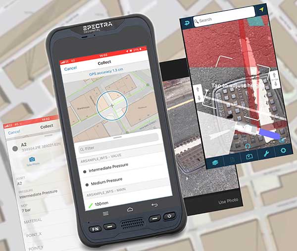
MGISS, a U.K. geospatial specialist, has released a new version of its web app TopoGrafi that allows for the display of 3D data in real-world models. With enhanced 3D data processing capabilities, TopoGrafi is an end-to-end platform for capturing buried asset data and processing it for augmented reality visualizations.
Aimed at the utility and infrastructure sectors, TopoGrafi is helping organizations in water and highway sectors enhance asset location data, improve on-site safety and reduce construction and maintenance costs.
Designed to be used alongside apps such as Esri Collector for ArcGIS, the TopoGrafi platform uses GNSS data.
It applies near-real-time conversions, transforming the recorded positions to local reference systems and aligning it with high-accuracy mapping including Ordnance Survey MasterMap.
The TopoGrafi toolkit also includes functionality to “snap” 3D features to each other and to other spatially referenced data, in order to create a true 3D model that can then be used to create Augmented Reality visualizations accessible from the desktop or in the field.
Hemisphere GNSS has launched two new GNSS receivers to enable better positioning for machine control applications. The new receivers are in addition to products announced earlier this week, including GradeMetrix application software and an array of compatible GNSS hardware components.
Designed for harsh construction environments, both the Vector VR1000 and the C321 base and rover (when combined with the new SiteMatrix software) are system components that empower heavy equipment manufacturers to deliver their own machine control and guidance solutions to their customers. Both also feature a powerful new web user interface.
Hemisphere GNSS made the announcements at Conexpo-Con/Agg 2017, which is taking place March 7-12 in Las Vegas, Nevada. Hemisphere GNSS is exhibiting at booth G71925.
Vector VR1000 Rugged GNSS Receiver
Vector VR1000 rugged GNSS receiver by Hemisphere GNSS. Photo: Hemisphere
Designed specifically for harsh machine-control environments, the Vector VR1000 multi-frequency, multi-GNSS receiver offers real-time kinematic (RTK) positioning and high-precision heading.
“The Vector VR1000 is our most robust GNSS receiver yet,” said Lyle Geck, product manager at Hemisphere. “The receiver offers a feature- and performance-packed combination of Athena RTK engine, Atlas L-band corrections, and excellent connectivity. With a baseline separation up to 10 meters, users can achieve heading accuracies of up to 0.01 degrees.”
The 744-channel VR1000 excels in difficult environments, tracking GPS, GLONASS, BeiDou, Galileo, QZSS and IRNSS. Its connectivity features support Ethernet, CAN, internal 400 MHz/900 MHz radio, serial, Bluetooth and Wi-Fi. It also has 12 multi-color LED indicators.
Powered by Athena GNSS engine, VR1000 provides centimeter-level RTK. Athena excels in environments where high-accuracy GNSS receivers can be used.
Integrated L-band adds support for Atlas GNSS global corrections for meter- to sub-decimeter-level accuracy while new Tracer technology helps maintain position during correction signal outages.
VR1000 also uses Hemisphere’s aRTK technology, powered by Atlas. This feature allows the receiver to operate with RTK accuracies when RTK corrections fail. If the VR1000 is Atlas-subscribed, it will continue to operate at the subscribed service level until RTK is restored.
C321 RTK Base and Rover
C321 RTK base and rover by Hemisphere GNSS. Photo: Hemisphere
Hemisphere GNSS also debuted the C321 GNSS Smart Antenna for heavy highway and site construction. When paired with the company’s SiteMetrix Site Management software, the multi-frequency, multi-GNSS C321 antenna can be used as an all-in-one construction base and rover site controller.
The C321 combines Hemisphere’s Athena GNSS engine and Atlas L-band correction technologies. The ruggedized antenna is designed for the most challenging environments and meets IP67-standard requirements.
Powered by Athena GNSS engine, the C321 provides best-in-class, centimeter-level RTK. Athena excels in virtually every environment where high-accuracy GNSS receivers can be used. Tested and proven, Athena performs with long baselines in open-sky environments, under heavy canopy, and in geographic locations experiencing significant scintillation.
Atlas GNSS Global Corrections. The C321 ships pre-configured to test-drive corrections from Hemisphere’s Atlas L-band corrections service. The bundled solution provides users worldwide with an easy way to utilize Atlas, including the worldwide H10 service offering 8 cm 95% accuracy (4 cm RMS). C321 also uses Hemisphere’s aRTK technology, powered by Atlas. This feature allows the receiver to operate with RTK accuracies when RTK corrections fail. If the C321 is Atlas-subscribed, it will continue to operate at the subscribed service level until RTK is restored.
SiteMetrix Site Management Software
Hemisphere’s SiteMetrix is a complete 3D/GNSS site management and inspection tool, implementing most grading, mining and landfill applications. SiteMetrix provides cut-and-fill information across the job site in real time, moving easily between a vehicle to a man-rover pole. SiteMetrix supports most GNSS receivers by offering a large GNSS library.
Using SiteMetrix offers easy-to-use stakeout, collection, volume computations and reporting, and as-built points. Developed as versatile software, SiteMetrix provides an incredible amount of direct import files, including DWG, DXF, TN3, GC3, LN3, TIN and GRD. With a customizable user interface, SiteMetrix can be as easy or advanced as necessary.
The Oregon Department of Transportation (ODOT) is embracing the growing trend in highway construction to go “stakeless” and push to full 3D design.
With more contractors using automated machine guidance applications, ODOT’s construction personnel are being asked to inspect projects with fewer stakes and visual indicators for line and grade. Employees are seeking to use the same data and information to determine line and grade when building or fixing stretches of road.
ODOT inspectors Jorge Jimenez and Mike Stennett at Multnomah Falls, preparing for a night-time paving operation. (Photo: Chris Pucci)
To address this need, rugged tablet maker DT Research worked closely with ODOT to design purpose-built Inspector Positioning Tablets that run GPS locating and 3D modeling applications, and take advantage of the Oregon Real-Time GNSS Network.
“MicroSurvey Field Genius surveying software is used to read XML files directly, allowing the inspector to work with the same files that the contractors received from the roadway designers,” said Chris Pucci, ODOT Construction Automation Surveyor.
The tablets enable ODOT to fully use its knowledge of the Oregon Real-Time GNSS Network and expertise in survey-grade RTK GNSS to achieve accuracies of +/0.05 feet.
The model DT391GS tablets have 9-inch touchscreens. The tablets can be used as handhelds or with an external antenna and pole. ODOT purchased one of four GNSS options offered by DT Research for the DT391GS tablets. The options enable inspectors and construction crews to employ a combination of GPS locating and 3D modeling to guide construction workers.
The goal is to allow the inspectors to make the same checks they would have made if there had been traditional construction staking on a project, not to make inspectors into surveyors, Pucci noted.
A one-day training is provided to train construction personnel before they are issued a tablet. “The tablets have been very well received by our construction inspection personnel,” he said.
The tablet project is now in the pilot phase with 20 tablets deployed to eight construction offices and more than 70 construction personnel having been trained. “We also just placed an order for 22 more tablets for the upcoming 2017 construction season,” Pucci said.