DroneShield’s RfPatrol MKII body-worn system antennas. (Photo: DroneShield)
DroneShield has received and delivered upon a follow-on order by a U.S. government agency for the company’s portable and handheld counter-UAS (C-UAS) solutions.
DroneShield is the maker of the counter-drone or anti-drone systems including RfPatrol and DroneGun MkIII. It has received contracts from the U.S. departments of Defense and Homeland Security, as well as other federal and state law enforcement agencies.
“We’re grateful for the continued trust that this organization has placed in us to help address a unique set of operational challenges. Our customer relationships are what fuel our commitment to push the boundaries of what’s possible in the counter unmanned space,” said Tom Branstetter, director of business development, DroneShield. “Every teammate at DroneShield understands the significance of the problems we’re solving for our end-users and it’s something we’re proud to support.”
DroneShield also recently announced deployments of its solutions for high-profile events including the World Economic Forum (WEF) in Davos, Switzerland, and IRONMAN Texas 2022.
The JNC, sponsored by the Military Division of the Institute of Navigation, will be held Aug. 24-26 (FEDCON U.S. ONLY) at the Northern Kentucky Convention Center in Covington, Kentucky (Greater Cincinnati, Ohio).
The Classified Sessions (Secret U.S. ONLY) will be held Aug. 27, at the Air Force Institute of Technology on Wright-Patterson Air Force Base, Ohio. Visit requests and approvals are required for all session attendees.
View the JNC 2021 program and register at ion.org/jnc.
JNC 2021 is the largest U.S. military positioning, navigation and timing (PNT) conference of the year, with joint service and government participation.
Four new panel sessions have been introduced to this year’s technical program, which will host leaders and decision makers as they discuss and debate
MGUE Integration
Rapid Agile Development and Manufacturing
the National Critical Infrastructure Threat
Combatant Command Joint Urgent Operation Need (Secret, U.S. Only).
The technical program will focus on enhancing dominance and resilience for warfighting and homeland security PNT, and will include keynote addresses from:
William B. Nelson, director, Assured Positioning Navigation &Timing (APNT) Cross Functional Team (CFT), U.S. Army Futures Command
Ray Chartier, Jr., Safety of Navigation Mission manager, National Geospatial Intelligence Agency
General David D. Thompson, vice xhief of Space Operations, United States Space Force
Bradford Parkinson, Stanford Center for PNT
Attendance Restricted for JNC Technical Sessions
Conference attendance for both FEDCON (U.S. ONLY) (Aug. 24-26) and Classified Sessions (U.S. ONLY) (Aug. 27) will be screened by the Joint Navigation Warfare Center. Visit requests and approvals are required for all technical participants.
The exhibit hall is open to any registered conference attendee or exhibiting company representative, and all materials shall be designated DISTRO A/Publicly Releasable After Review.
Government-issued photo ID will be required to access all conference events.
If you have questions, contact the Institute of Navigation at [email protected] or by calling +1-703-366-2723.
The U.S. Department of Homeland Security (DHS) Science and Technology Directorate (S&T) is hosting the 2020 GPS Equipment Testing for Critical Infrastructure (GET-CI) event. This event will take place during the summer of 2020.
The revised the due date for responses is May 8, 2020. Visit this site for more information.
S&T’s GET-CI events are a series of annual evaluation events intended for manufacturers of commercial GPS equipment used in critical infrastructure as well as critical infrastructure owners and operators.
DHS S&T recognizes the importance of accurate and precise position, navigation and timing (PNT) information to critical infrastructure and has a dedicated multi-year program to address GPS vulnerabilities in critical infrastructure, with a multi-pronged approach of conducting vulnerability and impact assessments, developing mitigations, exploring complementary timing technologies, and engaging with industry through outreach events and meetings.
Through these sustained efforts, the goal of the program is to increase the resiliency of critical infrastructure to GPS vulnerabilities in the near-term future.
Examples of measures that can be taken to enhance resiliency can be found in a DHS issued set of best practices released via ICS-CERT, titled “Improving the Operation and Development of Global Positioning System (GPS) Equipment Used by Critical Infrastructure.”
The Geospatial Management Office (GMO) is the designated coordinator of geospatial activities throughout the core of the Department of Homeland Security headquarters and its component agencies.
Part I described how and why the GMO was formed and some of the early activities when resources were limited and expectations were low. Following the devastation along the Gulf States from Hurricane Katrina, the efforts to coordinate and empower the GMO gained focus and energy.
Image: USDHS
Needed: Better coordination
The magnitude of devastation caused by Hurricane Katrina, the uneven response and the inability for all levels of government to act in a unified manner prominently showed the gaping hole in the nation’s geospatial coordination mechanisms. The irony in this lack of coordinated government action, and the blame placed on President Bush’s administration, was that the lack of a geographic framework had been identified as a vulnerability since the late 1800s following the Civil War and never fully addressed.
A patchwork of Executive Orders and other stop-gap actions were in place, but action was needed by the Legislative Branch to finally address this, and, as is too often the case, it took a major disaster to cut through the politics and make this happen, resulting in the Geospatial Data Act. For a more in depth analysis of the Geospatial Data Act read the November 2018 Geospatial Solutions article “Geospatial Data Act Will Bring Huge Changes to America and the World.”
Hurricane Katrina had a sobering influence on federal agencies, providing renewed focus to find new ways to share information, and communicate openly and effectively using a common standard and language.
Dan Cotter, director of the GMO from 2005 through 2007, understood this challenge. Following his predecessor, Ryan Cast (the first director of the GMO), Cotter furthered the relationship with the Federal Geographic Data Committee (FGDC), establishing a Homeland Security Working Group with several sub-groups to advance DHS’s mission. Heavy lifting began on the symbol standards, data model and the U.S. National Grid (USNG).
This collaborative effort was furthered when the GMO secured funding for the first agency-wide enterprise license agreement (ELA) with Esri for GIS applications, training and services. The ELA reduced the cost and administrative difficulties surrounding procurement of GIS software. This dramatically increased the number of GIS practitioners seeking to partner with DHS, FEMA and the GMO.
Cotter was tapped to be the DHS chief technological officer in March 2007, passing leadership to Jeff Booth, who advanced the portfolio and led significant efforts to optimize the geospatial toolset of DHS while migrating it into the federal data-center environment.
Establishing a culture of trust does not come easy in bureaucracies, and this was no different for DHS. Being a relatively new agency, agility and eagerness were key traits, especially with a very fast-paced and high-stakes environment. People would volunteer to take on requested tasks, but that blurred the lines of responsibility.
The launch of GeoCONOPS
The HSE GeoCONOPS is a strategic roadmap to understand and improve the coordination of geospatial activities across the entire spectrum of the Nation. Updated on July 22, 2019, (Graphic: GeoPlatform.gov)
The FGDC and other working groups helped make introductions for the DHS GMO, which furthered the need to clarify each department’s role in the bigger geospatial picture. Defining these various operational roles and responsibilities led to the creation of the Geospatial Concept of Operations, or GeoCONOPS.
GeoCONOPS was a multi-year initiative, and is a playbook for a range of disaster-related events. Though initially limited to the disaster response and FEMA’s mission, GeoCONOPS was a structured community effort to clarify the types and timing of critical geospatial data and analysis needed in a disaster and continues to grow to address other DHS mission areas.
GeoCONOPS was initially published annually as a book, but changes were made too often and it is now only maintained as a website. GeoCONOPS describes the use of geospatial technology in the five mission areas of DHS:
Prevent
Protect
Mitigate
Respond
Recover
It also contains a curated inventory of geospatial resources available to the homeland security enterprise. The final version of the book (v.6, 2015) is available for download. Though often seen as a product, it is likely that the process behind the GeoCONOPS development was of equal or more value as it helped to define the lanes and build much-needed trust among the federal geospatial actors.
Cover of HSE GeoCONOPS resource book, v.4. (Image: Geoplatform.gov)
Through this effective collaboration model, the GMO benefitted from other significant advances elsewhere in the agency and the broader geospatial community. The development of the Homeland Security Information Network (HSIN) delivered value as a portal for the exchange of information and geospatial products on a common operating network among DHS member partners. If there is a major event taking place, such as political conventions, the Super Bowl, or the Boston Marathon, HSIN is sure to be part of the event’s command and control.
Its value was further proven by leveraging HSIN’s user-authentication capability, providing a trusted access-control mechanism for HSIN and other web-hosted geospatial capabilities. These access controls greatly reduced the deployment burden on the Geospatial Information Infrastructure (GII), which is an on-premises version of Esri’s ArcGIS Online suite.
The GII allows for trusted partners to gain access to hosted data, create working groups, and develop and share maps and geospatial applications. The GII also provides access to customized Common Operational Picture (COP) applications providing geospatial situational awareness for a number of operational partners.
These COPs are a result of their own evolutionary pathway, leveraging technology developed by and for the National Geospatial-Intelligence Agency (Palenterra) and through a first-generation viewer called the Infrastructure Critical Asset Viewer (iCAV). Now, with the tools in the GII, highly customized COPs and dashboards are developed for specific events and incidents and shared on an as-needed basis with the full range of stakeholders.
Where NGA and DHS intersect
DHS’s development of a national geospatial dataset put NGA and DHS on intersecting paths. The National Geospatial-Intelligence Agency (NGA) only focused on foreign threats and supporting the warfighter, but after the attacks of September 11, 2001, homeland defense was added to its mission.
NGA’s proven success internationally allowed it to quickly focus on acquiring and developing the best available sources of data. This conventional mission for NGA led to the formation of a new stakeholder group; hence, the creation of the Homeland Foundation Level Data (HIFLD) committee, which developed the first national dataset designed for homeland security and critical infrastructure protection, the Homeland Security Infrastructure Program (HSIP).
Having been initiated in the intelligence community, HSIP’s distribution was strictly limited, which inhibited its adoption across the mission space. To broaden its use, plans were developed to migrate all or much of the program to DHS and to shift the burden of restriction from the need-to-justify sharing to the need-to-justify restricting. With this new emphasis on sharing and openness, HSIP evolved to the current HIFLD Open and HIFLD Secure versions.
The GMO solidified its mission and purpose with the elements of community, transparency, security, technology and data falling into place. Through the leadership of the former GMO directors, the foundation they laid established the GMO as a respected and strong advocate throughout the agency and its partners, from local governments up to the federal level, becoming known as the Homeland Security Enterprise (HSE).
The HSE established a very real link extending from the on-scene first responder to the White House. By the time David Alexander, Ph.D., passed the baton to David Lilley in 2016, the GMO could deliver on its promises and was ready to expand outward. Lilley focused on realigning efforts to match DHS’s policy supporting National Special Security Events (NSSE) and community outreach through its network of 78 fusion centers.
Shortly after Lilley departed DHS, Hurricane Harvey’s torrential downpours and historic deluge began. Acting Director Michael Donnelly agreed to an innovative HIFLD solution to support FEMA operations to help mitigate the flood of data and requests that typically accompanies events of this magnitude.
Hurricane Harvey was Donnelly’s initiation. Following this and storms that followed, Donnelly focused on steadily maturing the GMO through deliberate outreach efforts and strengthening partnerships, building on outreach to regional fusion centers and non-traditional mission areas such as cybersecurity.
While not typically an operational player, the DHS Geospatial Management Office has become a trusted partner to those on the front lines, providing expertise, data, insights and architecture. The GMO is a foundational resource for operators, elevating their capabilities as a force multiplier.
While we can only hope against another cataclysmic natural disaster or major attack, when one does occur, the nation’s geospatial community is better prepared to respond to and recover from whatever comes.
As the saying goes, the better one strives to become, the greater becomes one’s enemies; so, as threats continue to evolve, our investments into geospatial technologies and critical infrastructure will pay dividends now and in the future helping to secure America’s safety here and abroad.
Remember, next time you are watching a large, national level sports game or a big storm approaching, know that others are watching, too. Behind the scenes another game is being played — one with much higher stakes. The players, you’ll not see, and the names, you’ll never know, but safety is their mission and GIS one of their primary tools.
Nate Smith — co-author and main contributor because of his work with the GMO — gave the following presentation to GeoDC, Washington, D.C.’s, geospatial community of interest on GeoCONOPS.
Epilogue
An inspiration for this article was to recognize the DHS GMO and its partners for their growth and utility as demonstrated during Hurricane Harvey, on the assumption that it was not otherwise acknowledged by the community. Well, awkwardly, in between this two-part drama, recognition did come from the Federal Geographic Data Committee in the form of the 2018 Doug D. Nebert National Spatial Data Infrastructure (NSDI) Champion of the Year Award.
Nate Smith has worked at the confluence of geospatial information and disaster management in both the domestic (U.S.) and international domains since 1992. He has been an innovator and pioneer in this discipline through his work supporting USAID’s Office of Foreign Disaster Assistance, FEMA’s GIS Solutions Branch and the DHS Geospatial Management Office.
He refined his knowledge of requirements through work as an emergency first responder and international humanitarian, and has shared his knowledge and experience through courses delivered at a number of Universities. His background includes deployments to disaster locations around the world in support of operations and coordination efforts for events ranging from insect infestation to conflicts.
He is currently an independent consultant affiliated with the Florida International University Extreme Events Institute and FIU’s Academy for International Disaster Preparedness. He earned a BA in Geography from UMBC and a Masters in Urban and Regional Planning from Virginia Tech.
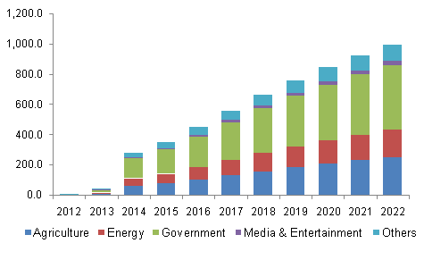
The global commercial UAV market is expected to reach $2.07 billion by 2022, according to a new study by Grand View Research Inc.
Increasing applications in agriculture and law enforcement are expected to drive commercial UAV industry growth over the forecast period. Commercial drones are finding applications across various industry verticals globally. Every industrialized country in the world is making investments in drones, thus driving the scope and technological developments for applications in the commercial UAV market.
Drones are contemporary alternatives for activities where human life cannot be risked. Such drones find applications in various industrial verticals including military, homeland security, retail and agriculture. The demand is significantly higher for military applications, although commercial applications are progressively catching up.
Aviation regulatory bodies such as the Federal Aviation Administration (FAA) have imposed restrictions on the use of such drones taking into consideration the difficulties in managing such huge air traffic and the safety of the citizens. However, the FAA is known to be undertaking an initiative to accelerate the UAV approval process for public safety agencies and broaden access to civilian organizations for a variety of commercial, industrial and other applications.
Further key findings from the report suggest:
Rotary blade drones accounted for more than 70 percent of the global market share owing to their easy maneuverability and compact design. Moreover, such single and multi-rotor drones equipped with rotary blades have Vertical Take-Off and Landing (VTOL) abilities for applications, where there is limitation of space for fixed blade drones to take off. The development of advanced hybrid UAVs that operate on non-conventional sources of energy and nano, small miniature drones serve multiple applications across various industry verticals.
Government applications dominated the global commercial UAV industry constituting more than 40 percent of the market share in 2014. Increasing applications in law enforcement, security and surveillance, R&D activities, infrastructure, disaster management, and environmental studies have led to an increased demand for such unmanned aerial vehicles from the concerned government agencies. Innovative applications across agricultural sector have made it the fastest growing application segment, which is projected to grow at a CAGR of more than 18 percent from 2015 to 2022. Special agricultural drones can take snapshots of fields and help in analyzing crops. In addition, fix winged drones can be used for applications such as watering, spreading seeds, fertilizers, and pesticides over large farm fields that drastically reduce the time required and increase the efficiency.
North America is expected to grow at a CAGR of more than 16 percent over the forecast period on account of concentration of major drone manufacturers and increasing applications in the commercial sectors in the region. Governments and technology giants across the world are striving hard to provide internet to the people as a basic necessity. Facebook Inc. recently acquired Ascenta, a drone manufacturer for its pilot project to provide internet in remote areas using drones as movable wireless access points. Relaxation in regulations and increasing use of drones in law enforcement activities in Europe have led to the regional industry growth.
Major industry participants include AeroVironment Inc., BAE Systems, DJI, Elbit Systems, Parrot SA, Israel Aerospace Industries, The Boeing Company, and Textron Inc. Manufacturers resort to mergers and acquisitions as their key growth strategy to make their presence felt in the industry. Augmented funding, technological collaborations, and government agencies are expected to emerge as critical success factors for industry growth.
Grand View Research has segmented the global commercial UAV market on the basis of product, application, and region:
Commercial UAV Product Outlook (revenue, USD billion, 2012-2022)
Fixed wing
Rotary blade
Nano
Hybrid
Commercial UAV Application Outlook (revenue, USD billion, 2012-2022)
Agriculture
Energy
Government
Media & Entertainment
Others
Commercial UAV Regional Outlook (revenue, USD billion, 2012-2022)
When I was the GIS manager of the Atlanta Regional Commission, the most rewarding and important work we did was geospatial support for our first responders. The culmination of this effort was creation of a portable GIS that we could set up in the field on short notice anywhere in the region to provide situational awareness for first responders.
The system consisted of two laptops, external hard drives, a HP “E”-size plotter, foam-board laminator and an LCD projector — all housed in a portable tent. We used ArcInfo and ArcView to build and overlay vector data on ortho/oblique aerial imagery to aid visualization.
We found that police and firefighters especially liked our large laminated plots of imagery overlaid with street data, because the aerial images were easy to understand and the GIS data provided needed location references. The hard-copy plots required no computer and could be marked up with grease pencils.
Helping in our small way, we provided the same kind of large plots of New Orleans to the Louisiana National Guard days after Hurricane Katrina hit. We later learned that the plots were used by National Guard headquarters to keep track of search-and-rescue efforts by marking up neighborhood blocks with grease pencils and recording search results. They crossed off buildings that had been searched and recorded urban rescue information such as who did the search, and the date and number of live or deceased bodies found. The hard-copy plots were a low-tech embodiment of higher tech GIS data and imagery.
Nine years later, the National Geospatial-Intelligence Agency (NGA) developed a similar but higher tech and more robust system called GeoQ.
GeoQ: Geographic Work Queueing and Tasking System
GeoQ is an open-source geographic tasking and management system that facilitates collection and display of diverse geographic and geographically tagged data across large areas to provide situational awareness for all involved. As needed, the large areas can be broken down into small grid squares and assigned to teams or team members for detailed analysis or tasking.
The system is designed to be very transparent so all involved can view the workflow and assist as needed, while avoiding duplication of effort. This NGA video is a well done and rapid overview of GeoQ.
GeoQ software was developed by NGA and the MITRE Corporation to leverage NGA tools and data to the benefit of Homeland Security personnel. In 2013, the leadership at NGA made a gutsy decision to share some of their unclassified geospatial tools with the nation’s first responders through GitHub, an open-source software developers’ online collaboration environment. With more than 2 million participating programmers, GitHub hosts more software source code than any other single service in the world.
GeoQ was the first NGA product shared through GitHub, and was in keeping with a change in philosophy at NGA to take advantage of feedback and improvements generated by the huge and diverse talent pool available through GitHub. NGA was the first intelligence agency to share some of its work in this open-source environment, and the results have been extremely beneficial to all involved.
The Huntsville Connection
With more than 70 geospatial firms and agencies, Huntsville, Ala., has always been an early adopter of geospatial technology. Several years ago it was again a Huntsville team that developed a first-ever Google Earth Enterprise-based emergency response system called Virtual Alabama. The system was so effective that eight other states adopted the model. Work was underway to build a national version when Google announced the phasing out of Google Earth Enterprise. We now know that Google was not motivated to build authoritative geospatial systems, but was focused on building products and services that attracted customers so it could accomplish its primary business of selling advertising.
Fortunately, the work of the Virtual Alabama team was not wasted. Team members became experts regarding first-responder operations and their unique situational awareness requirements. They learned that first responders needed much more than just a GIS. The best analogy I can think of is that one could use PowerPoint as a word processor, but that wouldn’t be a very efficient system. Likewise, MS Word could be used for presentations, but not as elegantly as PowerPoint. The same holds true for rapid dissemination, communication and perception of a common operational picture. Geospatial tools and analysis are part of situational awareness, but the work flow and many components are different, not necessarily spatial and need to be assembled and processed at their own pace.
The timing was almost perfect, since GeoQ was released as Google Earth Enterprise was being phased out. Huntsville again seized the opportunity to build on its experience, and GEOHuntsville became a prime GeoQ testbed. I recently met with Chris Johnson, one of the early Virtual Alabama leaders and president of A Visual Edge, Inc., a Huntsville geospatial firm. She demonstrated GeoQ and Huntsville’s role in advancing the technology.
GitHub has a very thorough description of GeoHuntsville, a non-profit 501c6, and its role with NGA to test and share lessons learned through a “Blueprint for Safety” pilot project involving other cities to improve rapid disaster response. The sharing of lessons learned, code sets and documentation through the multi-city collaboration is called “Exemplar City.”
Another aspect of the Blueprint for Safety is support of rapid sensor deployment in support of first responders through common standards. Sort of a “plug-and-play” for complex devices. (See the GeoQ projects page and the OpenSensorHub.)
There is quite an extensive collection of material on GitHub regarding GeoQ and other NGA, projects including support of FEMA and GeoQ technical specifications. NGA doesn’t directly support these efforts, with legal language such as “NGA assumes no responsibility for the use of the software by any parties, and makes no guarantees, expressed or implied, about the software quality, reliability, or any other characteristic.” Still, NGA is behind the creation of the software and is working on other tools and support that will expand the capabilities. Participation of both GeoHuntsville and the Federal Emergency Management Agency (FEMA) bodes well for future use, since I don’t envision the same situation we ran into with Google and Virtual Alabama/USA.
Update on What3Words
In February, I wrote about what3words. The simple what3words system is now available as a locator, accessible via the Esri ArcGIS platform.
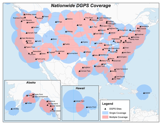
Twenty-two NDGPS sites that serve coastal areas would remain operational under the proposal.
An Aug. 18 Federal Register notice proposes shutting down the Nationwide Differential Global Positioning System (NDGPS) in January 2016 because of a decline in its use, except for sites in coastal areas.
The notice, issued by the U.S. Coast Guard (USCG), Transportation Department (DOT) and Corps of Engineers (USACE), reads:
The Nationwide Differential Global Positioning System (NDGPS) service augments GPS by providing increased accuracy and integrity using land-based reference stations to transmit correction messages over radiobeacon frequencies. The service was implemented through agreements between multiple federal agencies including the USCG, DOT, and Army Corps of Engineers, as well as several states and scientific organizations, all cooperating to provide the combined national DGPS utility.
However, a number of factors have contributed to declining use of NDGPS and, based on an assessment by the Department of Homeland Security, DOT and USACE. DHS, DOT and USACE are proposing to shut down and decommission 62 DGPS sites, which will leave 22 operational sites available to users in coastal areas.
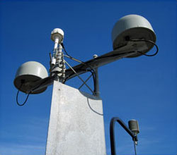
A DGPS reference station antenna.
Contributing factors cited in the decision are:
USCG changes in policy to allow aids to navigation (ATON) to be positioned with a GPS receiver using Receiver Autonomous Integrity Monitoring (RAIM), which assesses the integrity of a GPS signal within the receiver;
increased use of Wide Area Augmentation System (WAAS) in commercial maritime applications, which uses ground-based reference stations and satellite communications to improve accuracy;
limited availability of consumer-grade NDGPS receivers;
no NDGPS mandatory carriage requirement on any vessel within U.S. territorial waters;
the DOT Federal Railroad Administration’s determination that NDGPS is not a requirement for the successful implementation of Positive Train Control (PTC), which provides the railway system the capability to positively enforce movement authorities along railroad systems.
In April 2013, announced that DHS and DOT were in the process of analyzing the need for NDGPS. “The response to the 2013 notice was limited, but the responses received were well informed on the NDGPS system, its use, and current and potential applications,” the notice reads. “While a limited number of responders found the broadcast of corrections to be beneficial, no respondents reported the discontinuance of DGPS broadcast to be detrimental or harmful. Ship pilots in particular noted that DGPS can be critical in confined waterways for precise ship-handling maneuvers.”
Public comments on the proposed shutdown and decommissioning of 62 DGPS sites are being accepted until Nov. 16. Termination of the NDGPS broadcast at these sites is planned to occur on Jan. 15, 2016.
Full details on how to submit public comments can be found on the Federal Register page.
A new report by Visiongainexamines geospatial data analysis for defense and homeland security — a world market worth $9.7 billion in 2014. The report, “Governmental Geospatial Intelligence (GEOINT) Solutions Market 2014-2024: Digital Mapping, Geographic Information Systems (GIS), Cloud-Based Geo-Analytics & Geo-Data Exploitation for Defence & Homeland Security” is being offered by Reportbuyer.com.
Advances in technologies such as cloud and 3D modeling — together with increased availability of high-quality, high-accuracy geospatial data, especially from space-based remote sensing satellites — are propelling the market for governmental GEOINT solutions, Reportbuyer.com said.
“The coming decade will see governments around the world scrambling to acquire GEOINT capabilities on increasingly higher scales, to ensure they stay on top in the ‘information superiority’ race,” Reportbuyer.com said in a press release. “At the moment, outside the U.S. this is a relatively young market, at the very beginning of a period of large international expansion over the next ten years.”
According to Reportbuyer.com, geospatial information exploitation technology is one of the vital enablers and defining aspects of 21st century defense, intelligence and homeland security capabilities and operations. In a digital age where the vast majority of data has a location and time, GIS and GEOINT systems provide the means to reference it geographically.
“In this visual context, complex dynamics, patterns and relationships can be revealed, analyzed and understood in a completely new way,” Reportbuyer.com said. “This takes ‘situational awareness’ to an entirely different level, and enables an unprecedented and powerful new type of analysis: geospatial analysis. A key part of this overall capability is a new generation of tools for advanced digital mapping and modeling, which extend the applications of GIS beyond intelligence, C2 (command and control) and the achievement of information superiority into areas like resource management, mission simulation, and down to individual soldiers.”
The 300-page report provides market forecasts and analysis for GEOINT solutions, 2014-2024, and sales value projections of the market with essential information on the technologies, GEOINT organizations and competitors. The report is available at Reportbuyer.com.
A low-cost, man-portable, reusable unmanned aerial vehicle (UAV) was one of several emerging technologies highlighted at the “Homeland Security: Detect and Protect, Novel Military Technologies for Commercial Use” technology-transfer and federal marketplace event held at the U.S. Army’s Aberdeen Proving Ground (APG) in Aberdeen, Maryland, on April 20.
Hosted by APG, the Maryland Technology Development Corporation (TEDCO), and the Tech Council of Maryland, the event showcased technologies under development in APG?s research labs and testing facilities that can be commercialized by local companies. The UAV garnered interest from the Department of Defense Technology Transfer and Commercialization National Center of Excellence for First Responder Technologies at the University of Pittsburgh; American Aerospace Advisors, Inc.; and CTRL Systems, Inc.
John Condon, mechanical engineer at the Weapons and Materials Directorate, U.S. Army Research Laboratory, led the presentation about the Switchblade UAV, which uses real-time video, infrared imagery, and Global Positioning System technology for surveillance applications. The UAV can conduct overhead intelligence-surveillance-reconnaissance of infrastructure while carrying such payloads as day/night video, high-resolution snapshots, and chem-bio detectors. It can also deliver remote sensors and warheads to preselected areas on the battlefield. The UAV was developed in collaboration with AeroVironment, Inc., a Monrovia, California-based developer of small UAV solutions.
The one-day homeland security program also included presentations focused on available joint research and patent license opportunities, such as Cooperative Research and Development Agreements, and examples of successful partnerships with APG. More than 250 business executives, entrepreneurs, and researchers from 13 states attended the event. Technology-transfer officials from TEDCO were on hand to provide information about state and federal funding programs that support technology-transfer projects.
For more information about this and upcoming technology programs, visit www.marylandtedco.org.