Tag: HxGN SmartNet

  • Racing to an autonomous finish

    Racing to an autonomous finish

    Photo: Penske Entertainment: Walt Kuhn
    Photo: Penske Entertainment / Walt Kuhn

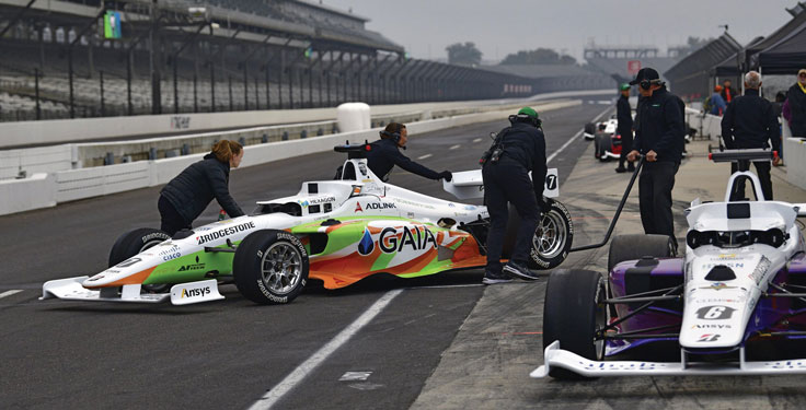
    Flipping the traditional scenario, in which car racers risk their lives on a racetrack, the Indy Autonomous Challenge (IAC) aimed to help save lives by improving collision avoidance systems, train future automotive engineers, and make the public more comfortable with autonomous cars. Held Oct. 23 at the Indianapolis Motor Speedway and organized by Energy Systems Network, the race saw 21 universities from nine countries forming nine teams to compete for a $1 million grand prize. Following in the footsteps of the DARPA Grand Challenge, first held in 2004 and later renamed the DARPA Urban Challenge, the IAC was the world’s first high-speed autonomous race. The winning team was TUM Autonomous Motorsport from the Technical University of Munich, Germany.

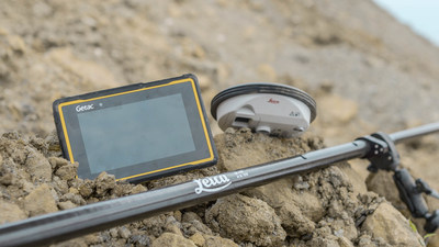
    All competing teams were given the same identical vehicle to work with, a Dallara AV-21, modified to carry no one in the cockpit and equipped with two Hexagon | NovAtel PwrPak7-Ds multi-frequency, multi-constellation GNSS receivers, six cameras (two of which faced backward), three lidar scanners and four radars. Each team had to develop its own autonomy-enabling software stack, including the algorithms and neural networks. All the components, except the computer, had to be commercial-off-the-shelf, available on the market. No sensors could be custom-made.

    Since 2001, Dallara has been the sole supplier of the Indy Lights series, a championship to prepare drivers for the NTT IndyCar Series. The Dallara AV-21 is a collaboration between Dallara’s Italian headquarters in Varano Melegari (Parma) and Dallara IndyCar Factory in Speedway, Indiana. The new car offers a modern, stylish appearance and provides the proper training required for drivers as the final step on the ladder to the NTT IndyCar Series.

    The process by which the automated vehicle sensors and computers were fused into a singular package and integrated into the AV-21 was led by Clemson University’s International Center for Automotive Research’s Deep Orange 12 (DO12) project. The Deep Orange process mirrors that of automotive original equipment manufacturers (OEMs), and the DO12 project scope allowed for engineering and innovation across multiple subsystems. Student groups within the DO12 team explored solutions within and across multiple subsystems, including:

    • vehicle-to-vehicle communications
    • perception systems
    • onboard computing
    • drive-by-wire chassis control systems
    • vehicle dynamics
    • vehicle-to-infrastructure communications
    • powertrain design and integration
    • vehicle demonstration based on high precision GPS.

    Hexagon’s Autonomy & Positioning division provided GNSS receivers and subject-matter experts to the Deep Orange 12 team. The team architected the sensor kit for the Dallara reference vehicle, which AutonomousStuff then replicated 10 times. The team did not compete in the IAC to avoid a conflict of interest and allow students to work closely with competitor teams from universities around the world. The PwrPak7-E1 contains a MEMS IMU to deliver Hexagon | NovAtel’s SPAN technology, a deeply coupled GNSS + inertial engine in a single-box solution. Each GNSS receiver has two antennas to provide heading. The Deep Orange 12 team used HxGN SmartNet RTK corrections, which brought the accuracy down to a few centimeters.

    Without developing a driverless decision-making algorithm, Clemson students tested the vehicle with the help of a high-precision positioning system. They developed a control algorithm that can track the optimal line around the Indianapolis Motor Speedway such that all vehicle systems could be validated in a simulated racing environment. Data from these tests were shared with the competition teams to aid in their development of driverless algorithms.

    Energy Systems Network will host a head-to-head, high-speed autonomous racecar passing competition at the Las Vegas Motor Speedway on Jan. 7, 2022, during the Consumer Electronics Show. Several of the teams that competed in the IAC, including the winner and finalists, will participate. The primary goal is to advance technology to speed commercialization of fully autonomous vehicles and deployments of advanced driver-assistance systems.

  • Hexagon offers new applications for HxGN SmartNet reference station

    Hexagon Geosystem’s Robert Martin discusses new applications for the company’s HxGN SmartNet reference station network at Intergeo 2018, which took place Oct. 16-18 in Frankfurt, Germany. The correction service enables GNSS-capable devices to quickly determine precise positions, and can be used in the machine control, GIS, precision farming, construction and surveying industries.

  • Getac tablet selected for Leica’s new survey package

    Getac tablet selected for Leica’s new survey package

    Leica Geosystems has selected Getac’s fully rugged ZX70 Android tablet for the new Leica Zeno GG04 Plus Tablet package, designed for utilities, public services, transportation and construction.

    The new partnership will allow Leica Geosystems to bring comprehensive geospatial data-collection capabilities to its customers in all terrains and weather conditions, according to a Getac news release.

    Leica Geosystems selects Getac's ZX70 tablet To power its new Zeno GG04 Plus tablet solution. (PRNewsfoto/Getac)
    Leica Geosystems selects Getac’s ZX70 tablet To power its new Zeno GG04 Plus Tablet solution. (PRNewsfoto/Getac)

    The Zeno Mobile data collection app and Zeno GG04 plus smart antenna are designed to help customers capture highly accurate geospatial data quickly and effectively in the field.

    By combining these products with Getac’s ZX70 Android tablet, Leica Geosystems has created a solution that offers measurement accuracy, connectivity and durability in a single, comprehensive package, Getac said.

    Compact and powerful, the Getac ZX70 is comfortable to use with one hand, making it suitable for demanding field surveying work.

    Its Android operating system supports Leica’s Zeno Mobile software, allowing for high-accuracy GNSS positions to be utilized and rich attribute data to be collected easily in the field.

    Any authorized Android app can also be installed on the device, depending on the required workflow or back office systems used, bringing a high level of usability and familiarity out of the box, Getac said.

    Additional key features include the 7-inch IPS display, which is easy to read in all environments, including direct sunlight. The LumiBond 2.0 touchscreen allows for full operation of the tablet in the rain and with gloves on, essential for outdoor surveying work.

    The Getac ZX70’s integrated 4G modem can transmit large data files quickly and easily, even from remote locations.

    The fast, stable and reliable data connection allows users to effectively utilize Hexagon Geosystems’ HxGN SmartNet correction service, enabling accurate GNSS measurement to within one centimeter.

    The ZX70 offers durability, connectivity and usability, and has been designed to withstand shocks, drops, rain and vibration, the company added.

  • HxGN SmartNet, AZGPS to expand GNSS correction services in US

    HxGN SmartNet has partnered with AZGPS LLC to expand access to quality network correction services for GNSS users in the southwestern United States.

    HxGN SmartNet, a high-precision, high-availability GNSS network correction service, is provided by Hexagon’s Geosystems division. AZGPS, based in Florence, Arizona, serves professionals across Southern California and Arizona who rely on high-precision GNSS with network correction services, professional support and training.

    The company will remain the local point of contact in the region and now has access to the infrastructure and resources of HxGN SmartNet, including HxGN SmartNet stations and a wide array of Hexagon services.

    “Our number-one goal is to help our customers succeed,” said Travis Thompson, AZGPS. “The ability to leverage the resources of HxGN SmartNet will enable AZGPS to provide even more benefits to GNSS users. We look forward to continuing the superior service our customers have come to rely on for more than 13 years while staying on the leading edge of technology.”

    HxGN SmartNet is fully open to all makes and models of GNSS equipment and is designed to provide the highest reliability and accuracy 24/7. Launched in 2010, HxGN SmartNet is a commercial GNSS network that offers a single connection point for coverage across North America.

    Built on the most advanced GNSS reference station software platform in the world, Leica Geosystems GNSS Spider, HxGN SmartNet provides high-precision, high availability network real-time kinematic (RTK) corrections for any application, the company said.

    A variety of different subscription plans are available at the state, regional and national level for any application requiring precision GNSS corrections. With more than 1,300 stations in 45 states and eight provinces, HxGN SmartNet North America offers extensive network coverage.

    “GNSS users across all applications know they can rely on HxGN SmartNet to make the investments and partnerships needed to provide the easiest, fastest and most precise positions in the industry,” said Wendy Watson, director of operations for HxGN SmartNet North America. “AZGPS has a long track record of providing excellent service to GNSS users in the Southwest through the AZGPS and CALVRS networks. This cooperation between two familiar names in the positioning services industry underscores HxGN SmartNet’s commitment to ‘any constellation, any application and open to all.’”