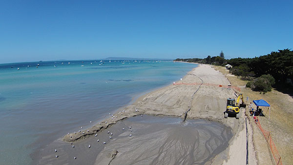
Shifting sands in Australia’s Port Phillip Bay left a popular beach without enough sand this past holiday season. As summer approached, the Mornington Peninsula Shire and Australian Department of Environment and Primary Industries (DEPI) decided to replenish Sorrento beach by dredging a nearby sandbank.
DEPI awarded the contract to Sandpiper Dredging because of its history of minimizing environmental impact. Sandpiper has a decade of dredging experience and builds its own precision dredgers in Tweed Heads, New South Wales.
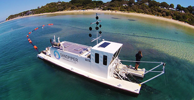
Erosion of Sorrento Beach required high-tech repairs. (Photo: Trimble)
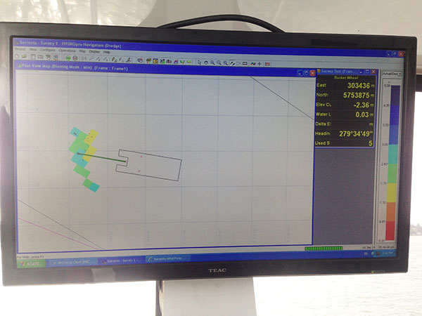
The contract specified the dredge ground extent and the minimum Australian Height Datum (AHD) height Sandpiper could dredge. To obtain precise 3D positions from the GPS receiver, GPS corrections were streamed in via cellular Internet from the Victorian government’s Continually Operating Reference System (CORS). Position and heading from the SPS461 receiver were interfaced into construction software to display dredge position. The inclinometer mounted on the dredge frame also interfaced with the software and allowed the AHD height of the cutter head to be displayed.
The dredge position displayed in the software allowed operators to stay within the dredge grounds and ensure no over-dredging occurred. The software was the central hub in the wheelhouse displaying and logging dredge positions and the AHD height of the dredge head.
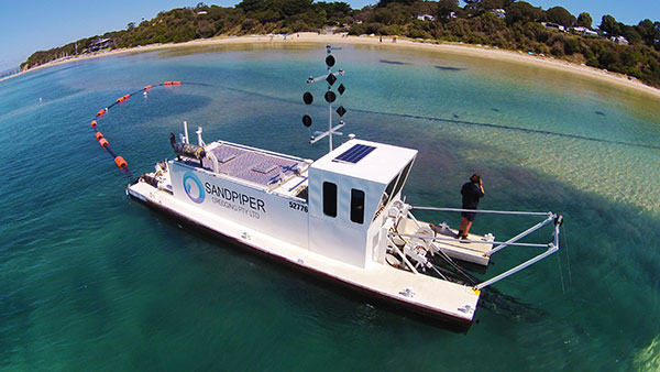
Machine-control positioning enabled Sandpiper to precisely place in 3D the cutter suction head on the dredge frame in real time. (Photo: Trimble)
The software also allowed the dredge operator to focus on controlling the dredge rather than trying to determine where to dredge. Using GPS and AUSGeoid09 removed the need for considering tide data because the software displayed the AHD height. The logged data could be delivered to the client as an as-built drawing.
The beach was replenished within budget and on time for the holiday season, and the community is now enjoying the restored beach.
Hydrographic Tech
To achieve the job specifications and efficient operation of their dredge, Sandpiper needed hydrographic survey technology on board. SITECH Construction Systems, a Trimble distributor, provided the company with:
Trimble SPS461 GPS heading and positioning receiver
Inclinometer to measure the angle of the cutter head frame
Trimble HYDROpro dredge software to display and log seabed levels. The software can be configured for a wide range of dredgers.
“After speaking about the challenges we had been facing, SITECH came back with the solution of the Trimble HYDROpro system, which meant we could dredge in exactly the right place and maintain coverage, all the while protecting the environment of the beach,” said Daniel Fristch, owner of Sandpiper.
HYDROPro at work on the Sorrento Beach project. (Photo Trimble)
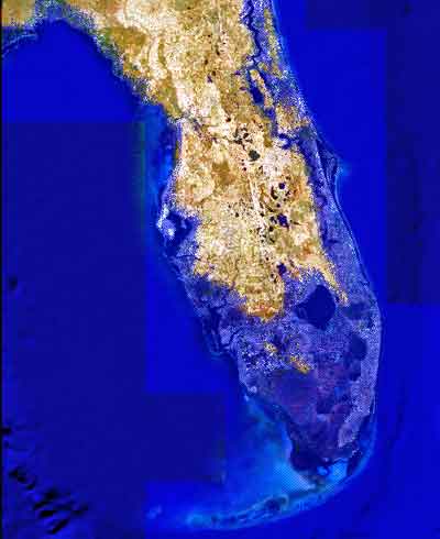
Image showing projected Florida flooding, from flood.firetree.net, using Google Earth with NASA data. Image from flood.firetree.net, using Google Earth.
Surveyors, prepare to get your feet wet. Global warming is about to hit you in the job list. By 2050, a majority of U.S. coastal areas are likely to be threatened by 30 or more days of flooding each year. This according to a December report in Earth’s Future, a journal of the American Geophysical Union.
[Parenthetically, the next issue of Survey Scene, in May, will be written by an actual geodesist. Until then, you have to put up with GPS World’s editor in chief — by no means a surveyor. Patience.]
The study used data from National Oceanic and Atmospheric Administration (NOAA) tide gauges to show the annual rate of coastal floods has accelerated in recent years. These are now five to 10 times more likely today than 50 years ago — and getting worse.
Mitigation decisions could range from retreating further inland to coastal fortification or to a combination of “green” infrastructure using both natural resources such as dunes and wetland, along with “gray” man-made infrastructure such as sea walls and redesigned storm water systems. And that’s not even mentioning such basics as redrawing property lines. Any way you look at it, surveyors are going to be involved.
“As communities across the country become increasingly vulnerable to water inundation and flooding, effective risk management is going to become more heavily reliant on environmental data and analysis,” said Holly Bamford, NOAA acting assistant secretary for conservation and management.
The recent U.S. Hydro 2015 conference in National Harbor, Maryland — an area particularly called out for vulnerability to the oncoming floods — naturally found a lot to talk about in this and related areas of interest for surveyors, with session tracks including: Effects of Climate Change on our Oceans and Waterways; Coastal and Ocean Mapping Initiatives; Advances in Unmanned System Technology, and several more.
Some of the papers presented that GPS World found of interest, and hopes to present or encapsulate in some form in the near future, include:
Resolving Systematic GPS Interference from Aeronautical Distance Measuring Equipment during Mission-Critical Shallow Water Multibeam Surveys
GPS Water-Level Buoy for Hydropgraphic Survey Operations
Examining the Uncertainty Associated with the Establishmenbt of an Ellipsoid to Chart Datum Separation Surface Using GNSS Buoys
Comparison of Horizontal and Vertical Resolvable Resolution between Repetitive Multibeam Surveys Using Different Kinematic GNSS Methods.
And those just came from the poster sessions. In the technical sessions, Jack Riley from the NOAA Coast Survey’s Hydrographic Systems and Technology Program presented a GPS Buoy Water Level Uncertainty Case Study.
Data from on High
Since you can’t get at a coastline from all angles — with any degree of stability, that is — data from overhead, sometimes far overhead, proves invaluable. Such as that provided by aerial digital imagery, LiDAR, and increasingly, satellites.
Because digital aerial images are already in electronic form, they can quickly be processed and made available to users. Most of the special cameras in use nowadays provide direct georeferencing capability, which allows camera position and orientation to be determined automatically using GPS and inertial measurement equipment. An entire mini-industry has grown up around integrating aerial data with that taken from ground surveys.
Light detection and ranging (LiDAR), a remote sensing system, became available for commercial topographic mapping in 1993. An airborne laser scanning system paired with a kinematic GPS receiver and an inertial navigation system can calculate and produce a highly accurate spot elevation. It is possible to obtain point densities that would likely take months to collect using traditional ground survey methods. The National Geodetic Survey (NGS) is currently implementing LiDAR into their shoreline mapping production process.
Our Record So Far
Coverage of these salty issues has been sparse in GPS World and associated newsletters, but not entirely absent. In 2006, the May issue featured “GPS Buoys Nautical Measurement.”
In 2008, Richard Langley edited an Innovation column on “Tsunami Detection by GPS,” featuring work for which co-author Attila Komjathy eventually won a GPS World Leadership Award in 2013. And in 2010, Langley brought forth an Innovation column on “Monitoring Water Level with GNSS.”
And way, way back in 2005, we published “Abreast of the Waves: Open-Sea Sensor to Measure Height and Direction.” This was prior to our digital era, so until we can scan a paper copy into here, we’ll simply give the abstract: “Accurate and timely information on open-sea wave conditions can help in preventing large-scale maritime disasters. This article describes a new, low-cost Global Positioning System (GPS)-based sensor that measures wave height with an accuracy of several centimeters and direction with an accuracy of 5 degrees. The receiver is mounted on a buoy, and a high-pass filter is used to extract the movement of the buoy and thus minimize GPS positioning errors. The data provided by the sensor is intended to improve wave prediction models. In addition, since this GPS-based sensor transmits only analyzed ocean wave data, it reduces the volume of data and leads to lower operating and acquisition costs. The article describes the concept of the GPS-based wave sensor, algorithms that are used for filtering and extracting wave data, as well as the results of open-sea trials.”
So there’s more to come. Watch this space. In the meantime, we leave you with Bob Dylan’s prophetic words, circa 1967.
Well, it’s sugar for sugar And salt for salt If you go down in the flood It’s gonna be your own fault.