Tag: ikeGPS

  • Esri releases Survey123 for ArcGIS with new Spike integration

    Esri releases Survey123 for ArcGIS with new Spike integration

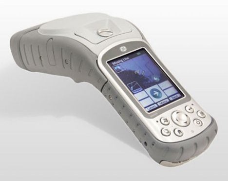
    The new software release of Survey123 for the ArcGIS mobile application now has Spike, a laser measurement solution by ikeGPS.

    The paired technology dramatically accelerates field data capture and asset inspection activities.

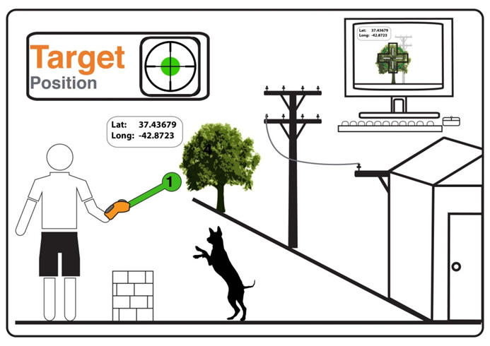
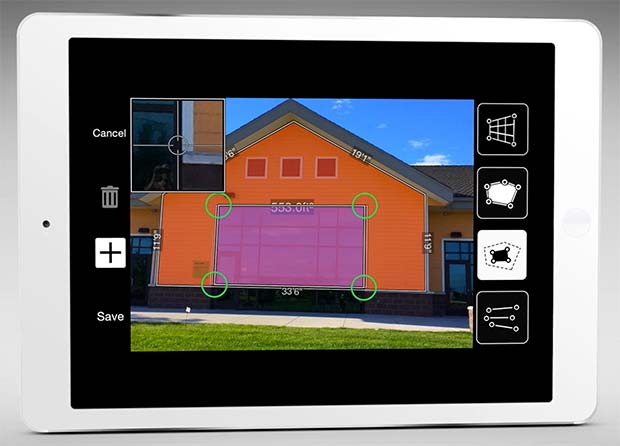
    Spike allows users to measure hard-to-reach objects from a distance by taking a photo with their smartphone or tablet. Users can then capture real-time measurements from that image, including areas, elevations, distances between two points, and GPS/GNSS location.

    Use of the Survey123 integration with Spike will be of interest to organizations that use mobile workflows for asset and facilities management, field asset inventories and inspections, damage assessments, and tactical operations including disaster response.

    Using Spike with Survey123 relieves fieldworkers of the burden of carrying paper maps to find the object of interest and lugging multiple pieces of specialized, expensive measuring equipment. Instead, with a single mobile device, fieldworkers can locate the correct asset, record measurement data, and report accurate data directly back to the office.

    “The new Spike integration with Survey123 is a game changer for many field data collection and inspection workflows where the dimension of physical objects needs to be captured. Spike and Survey123 provide quick return on investment,” said Ismael Chivite, Esri product management lead. “The simplicity of the solution enables it to be quickly deployed and with little training. Customers are very enthused about this low-cost solution that will streamline many of their critical workflows.”

    The ability to capture accurate measurements in the field is particularly useful when working in areas that don’t lend themselves to hands-on or close-up measurement. Spike’s laser can be used in ranges from 6 to 650 feet, with the option to select units of measurement in inches, feet, meters or centimeters. With it, a single fieldworker is able to more quickly and safely accomplish what may otherwise have taken multiple field staff and costly equipment.

    The Spike laser device mounts to smartphones and tablets and connects via Bluetooth with the mobile device’s camera.

    Survey123 with Spike runs on Apple iOS and Google Android smartphones and tablets.

  • ikeGPS describes Spike mobile solution at FedGIS 2016

    Ben Soliday of ikeGPS describes Spike, a remote data capture and measurement solution for the smartphone or tablet. He was interviewed by GeoIntelligence Insider columnist Art Kalinski for Geospatial Solutions at the Esri Federal GIS Conference, held Feb. 24-25 in Washington, D.C.

  • GE and ikeGPS Offer Mobile MapSight Device for Utility Workers

    GE and ikeGPS Offer Mobile MapSight Device for Utility Workers

    GE MapSight combines GPS, laser rangefinder, digital camera, and a digital compass into an all­-in-one field data collection device.
    GE MapSight combines GPS, laser rangefinder, digital camera, and a digital compass into an all­-in-one field data collection device.

    GE’s Digital Energy business is branding ikeGPS’ field measurement product as MapSight. The product integrates laser, camera and GPS technologies, enabling utilities to quickly and accurately collect measurement and location data on any of their joint-use utility poles or field assets, ikeGPS said in a statement announcing the partnership.

    The MapSight solution addresses many complexities of field data collection, the company said. It dramatically reduces the time required and cost incurred to collect joint-use pole data such as wire heights, widths, clearances, attachment points, diameters and span heights. The MapSight solution — which provides front-end remote measurement and data collection for utility assets — works seamlessly with GE’s SmallWorld Electric Office to provide an end-to-end data collection solution for utility workers. Once collected, the MapSight device can feed data directly into GE’s FieldSmart mobile applications and SmallWorld technology suite. Using the device, utility workers can greatly improve field data collection efficiency, typically reducing the time required to collect utility asset data by more than 50 percent, ikeGPS said.

    The MapSight handheld.
    The MapSight handheld.

    “ikeGPS is proud to announce that our solutions to the electric utilities segment have been integrated with GE’s software and branded as MapSight,” said Glenn Milnes, CEO, ikeGPS. “This agreement further validates the one-of-a-kind measurement capabilities that our solution offers GE and its utility customers.”

    MapSight enables field utility workers to remotely capture the location of their utility assets and every necessary measurement from a single photograph. This ability enables utility workers to measure the height of a span, the height of an object when the base is not visible and the distance between any two poles or points in the field and in real time. The geo-located photo provided by MapSight allows for further measurements to also be performed in the field. Another advantage of MapSight is that the unit provides field workers with consistent data, taking the guesswork out of measuring utility poles and assets. With the unit’s ability to geo-locate and time stamp photos, utility workers can easily verify when and where a measurement was made.

    “Together, GE and ikeGPS have created an end-to-end solution set for field utility data collection and analyzation,” said Bryan Friehauf, product line leader–software solutions, GE’s Digital Energy business. “Previously, data had to be collected manually using analog tools such as hot sticks, measuring wheels and a pen and paper. Our MapSight device streamlines the data collection and analyzation processes for field utility workers by enabling the collection of joint-use utility pole data quickly, digitally and remotely on a single, easy-to-use platform.”

  • Toolbox for GIS Location Data

    ikeGPS announced it has released its new toolbox, ikeTools, for rapidly capturing GIS location data and making measurements of complex objects from a remote location. Now you have the ability, right from your ikeGPS screen, to complete the most demanding field data capture jobs far more quickly and efficiently than ever before.

    ikeTools Data Capture Modes:

    Target Position: The work horse of ikeGPS mobile GIS data capture. Point ikeGPS at a remote object such as a tree, pole or building and capture its GPS location using the onboard GPS, laser range finder and compass. One shot and you’re on to the next object.

    Three Shot Height: Directly measure the height of an object, such as a pole, from a remote position, even when the base of the object is obscured.

    Missing Line: Calculate the horizontal distance between any two objects.

    Span Height: Calculate the vertical height above ground of a point on a span, for example the mid-span height of a cable or wire.

    Photo Only: Capture a high resolution photo of an object. Useful for documenting the conditions of located or measured objects, for identifying hazards for field crews and for including in assessments.

    True Size Poles: Capture a calibrated (TrueSize) photo of an utility or telecommunications pole with one shot, then transfer to a PC application for measuring the heights of the pole and its attachments.

    True Size PLS: Capture calibrated photos that are used on a PC to measure the heights of objects on electric utility poles. Exports directly to software products from Power Lines Systems, Inc.

    True Size UVM: A variety of measurements for utility vegetation management. Conduct Tree Assessments by measuring tree height, crown width, and trunk diameter at breast height (DBH).

  • ikeGPS Releases ikeTools

    ikeGPS announced it has released its new toolbox, ikeTools, for rapidly capturing GIS location data and making measurements of complex objects from a remote location. Now you have the ability, right from your ikeGPS screen, to complete the most demanding field data capture jobs far more quickly and efficiently than ever before.

    ikeTools Data Capture Modes:

    Target Position: The work horse of ikeGPS mobile GIS data capture. Point ikeGPS at a remote object such as a tree, pole or building and capture its GPS location using the onboard GPS, laser range finder and compass. One shot and you’re on to the next object.

    Photo: ikeGPS

    Three Shot Height: Directly measure the height of an object, such as a pole, from a remote position, even when the base of the object is obscured.

    Missing Line: Calculate the horizontal distance between any two objects.

    Span Height: Calculate the vertical height above ground of a point on a span, for example the mid-span height of a cable or wire.

    Photo Only: Capture a high resolution photo of an object. Useful for documenting the conditions of located or measured objects, for identifying hazards for field crews and for including in assessments.

    True Size Poles: Capture a calibrated (TrueSize) photo of an utility or telecommunications pole with one shot, then transfer to a PC application for measuring the heights of the pole and its attachments.

    True Size PLS: Capture calibrated photos that are used on a PC to measure the heights of objects on electric utility poles. Exports directly to software products from Power Lines Systems, Inc.

    True Size UVM: A variety of measurements for utility vegetation management. Conduct Tree Assessments by measuring tree height, crown width, and trunk diameter at breast height (DBH).