The Indian Space Research Organization (ISRO) and India’s Department of Space have signed a memorandum of understanding (MOU) with OPPO India to strengthen the research and development of the NavIC messaging service to provide a convenient and user-friendly platform.
The MoU will pave the way for future collaborations between ISRO and OPPO India to develop indigenous solutions by incorporating the NavIC short-messaging feature into smartphones released by OPPO India.
The MoU will enable ISRO and OPPO India to exchange technical information on the NavIC messaging services. This will enable the building of rapid, ready-to-use, end-to-end application-specific solutions that integrate the NavIC messaging service with OPPO’s mobile handset platform, with Indian end-users in mind.
The MOU also aims to help fulfill “Atmanirbhar Bharat,” which translates to “self-reliant India.” Atmanirbhar Bharat is a phrase used and popularized by Indian Prime Minister Narendra Modi and the Government of India in relation to the country’s economic development and vision.
Global mobile wireless standards body 3GPP has given its approval to the regional navigation system created by the Indian Space Research Organization (ISRO), known as NaVIC, reports The Times of India.
The approval was given for the system’s use in Rel-16 LTE and Rel-17 5G NR specifications, paving the way for wider commercial adoption of NaVIC and allowing it to be integrated with 4G, 5G and internet of things technology (IoT).
Once these specifications are adopted by Telecommunications Standards Development Society, India (TSDSI), IoT devices in India can make a switch from GPS to NaVIC.
Electronics companies can start designing and building integrated circuits and mass manufacture other products created to be compatible with NaVIC.
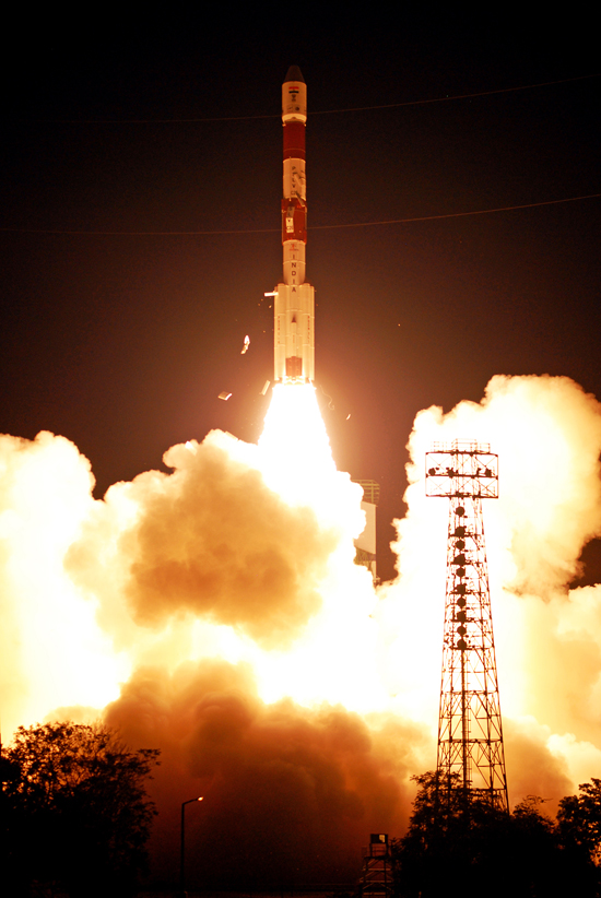
India is expected to launch into orbit its seventh and final navigation satellite on April 28, thus completing the Indian Regional Navigation Satellite System (IRNSS).
IRNSS-1G is expected to launch aboard a Polar Satellite Launch Vehicle (PSLV) rocket from India’s spaceport at Sriharikota in Andhra Pradesh at 12:50 local time.
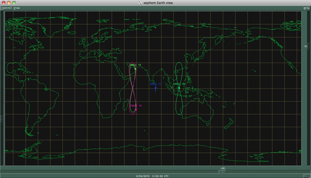
To date, India has launched six regional navigational satellites (IRNSS-1A, 1B, 1C, ID, 1E and 1F) as part of a constellation of seven satellites to provide accurate position information service to users across the country and the region, extending up to an area of 1,500 kilometers.
The full system comprises nine satellites — seven in orbit and two on the ground as stand-by.
The IRNSS will provide two types of services — standard positioning service and restricted service. The former is provided to all users and the latter is an encrypted service for authorized users.
Meanwhile, the Indian Space Research Organization (ISRO) is in the process of developing the front-end radio frequency chips for the satellite navigation system. The initial version is expected to be ready this year, ISRO chairman told the New Indian Express.
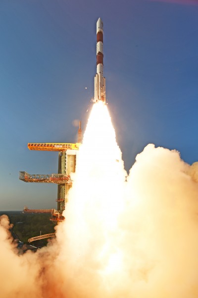
The fourth satellite in the Indian Regional Navigation Satellite System, launched on March 28, has arrived at its designated orbital slot.
Based on data supplied by the U.S. Joint Space Operations Center, IRNSS-1D is in an inclined geosynchronous orbit with an inclination of 30.5 degrees and a nodal longitude of 111.7 degrees east, within the allowed limits of the assigned longitude of 111.5 degrees east.
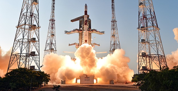
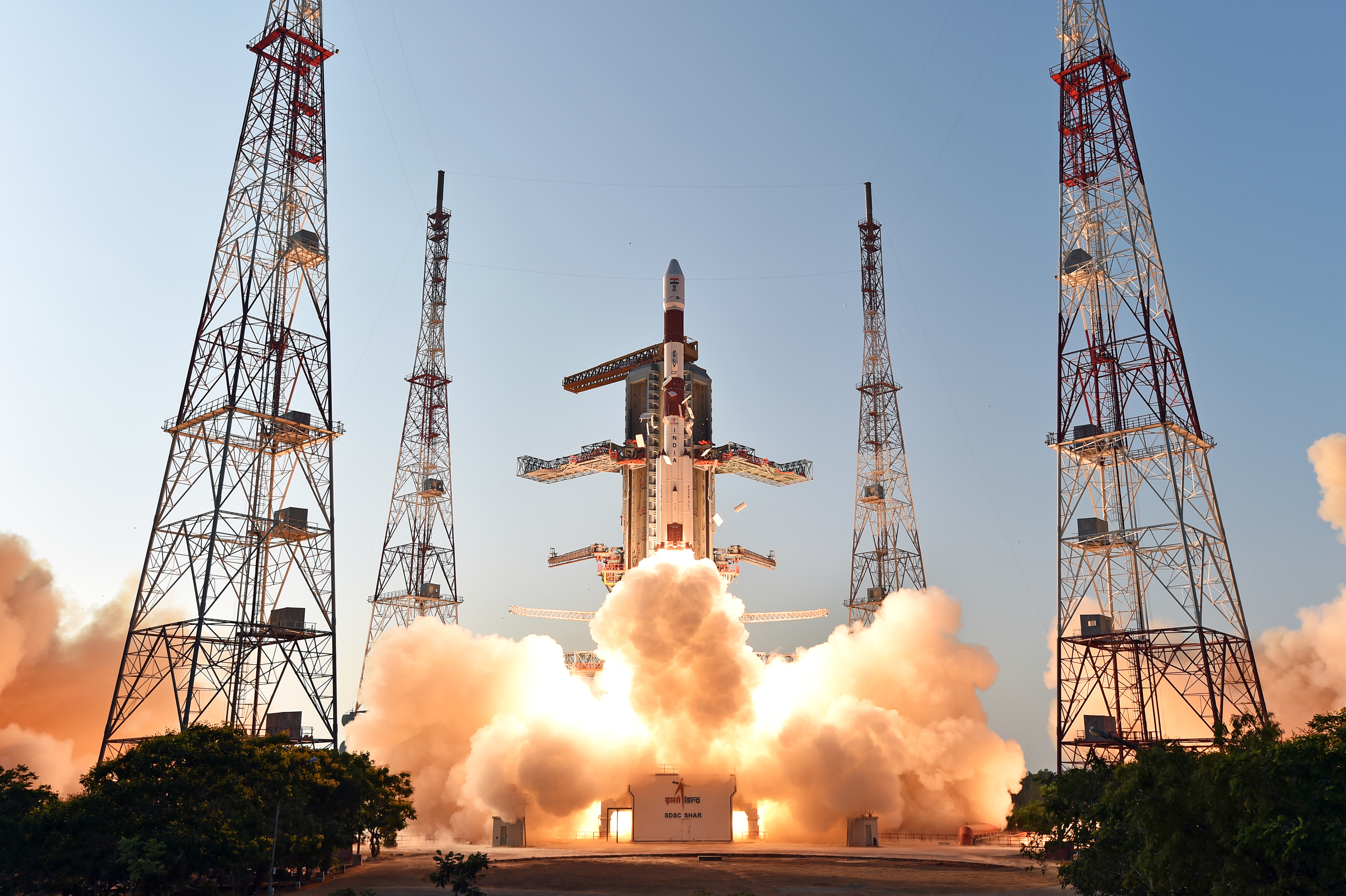
The fourth satellite of IRNSS satellite navigation constellation, IRNSS-1D, was launched onboard PSLV-C27 on Saturday, March 28, according to the Indian Space Research Organization (ISRO). The Polar Satellite Launch Vehicle blasted off at 11:49 GMT (7:49 a.m. EST), or 5:19 p.m. local time, at the Satish Dhawan Space Center on India’s east coast.
This is the fourth successful launch of a navigation satellite in less than a week, following GPS IIF-9 on Wednesday and Galileo 7 and 8 on Friday. A fifth navigation satellite, for the BeiDou constellation, is expected to launch tomorrow.
This is the 28th consecutively successful mission of the PSLV, the ISRO said. The “XL” configuration of PSLV was used for this mission. Previously, the same configuration of the vehicle was successfully used seven times.
After the PSLV-C27 lift-off with the ignition of the first stage, the subsequent important flight events took place as planned. After a flight of about 19 minutes, 25 seconds, the IRNSS-1D satellite was injected to an elliptical orbit of 282.52 km X 20,644 km, very close to the intended orbit, and successfully separated from the PSLV fourth stage.
After injection, the solar panels of IRNSS-1D were deployed automatically. ISRO’s Master Control Facility (at Hassan, Karnataka) took over the control of the satellite. In the coming days, four orbit maneuvers will be conducted from the Master Control Facility to position the satellite in geosynchronous orbit at 111.75 degrees East longitude with 30.5 degrees inclination.
IRNSS-D is the fourth of seven IRNSS satellites to be launched to provide navigational services to the region, according to the ISRO. The satellite was placed in geosynchronous orbit. Predecessors IRNSS-1A, 1B and 1C were launched by PSLV-C22, PSLV-C24 and PSLV-C26 in July 2013, April 2014 and October 2014 respectively. All the satellites are functioning satisfactorily from their designated orbital positions.
The IRNSS navigational system is regional, and targeted towards South Asia. The satellite will enable navigation, tracking and mapping services.
The next satellite, IRNSS-1E, is scheduled to be launched by PSLV. The entire IRNSS constellation of seven satellites is planned to be completed by 2016.
The launch of India’s fourth Navigation Satellite, IRNSS-1D, is now scheduled for 17:19 IST (11:49 UTC) on Saturday, March 28, from Satish Dhawan Space Centre, Sriharikota.
The launch was previously scheduled for March 9, then postponed until March 29 to replace a faulty telemetry transmitter on the satellite, according to the Indian Space Research Organization.
IRNSS-1D will be fourth in the seven-spacecraft Indian Regional Navigation Satellite System constellation. It will be flown into space in the Indian Polar Satellite Launch Vehicle-XL.
The space segment of the IRNSS consists of seven satellites: three in geostationary orbit and four in inclined geosynchronous orbit. The ground segment consists of infrastructure for controlling, tracking and other facilities. The entire IRNSS constellation of seven satellites is planned to be completed by 2015.
Both IRNSS-1A and 1B are functioning satisfactorily from their designated geosynchronous orbital positions. The first three satellites in the IRNSS series were launched from Sriharikota on July 1, 2013, April 4, 2014, and October 16, 2014. IRNSS-1E and IRNSS-1F satellites are expected to be launched before year end.
IRNSS is an independent regional navigation satellite system designed to provide position information in the Indian region and 1,500 kilometers around the Indian mainland. IRNSS will provide two types of service: Standard Positioning Services (SPS) — provided to all users — and Restricted Services (RS), provided to authorized users.
The launch of the fourth satellite for the Indian Regional Navigation Satellite System, previously scheduled for March 9, has been postponed until March 29 at 13:00 UTC. The delay is due to the replacement of a faulty telemetry transmitter on the satellite.
“We are targeting the last few days of March for the launch. A team is working on a new telemetry transmitter to replace the [faulty] one that failed in the satellite. After fixing it, all numerous tests that we conducted earlier must be repeated,” M.Y.S. Prasad, Director of the launch unit, Satish Dhawan Space Centre, Sriharikota, told The Hindu on Tuesday.
The launch, originally scheduled for March 9, was delayed March 4 when routine checks found a transmitter malfunctioning. The ISRO delayed the flight and removed the satellite from its launcher to put a new transmitter.
IRNSS-1D will be fourth in the seven-spacecraft IRNSS constellation.
— With information provided by the CANSPACE listserv.
During the integrated electrical checks on March 3 of the launch vehicle and satellite following closure of the heat shield, an anomaly was observed in one of the telemetry transmitters of the satellite, according to a post on the Indian Space Research Organization (ISRO)’s Facebook page.
“In order to resolve the technical anomaly through further test, simulation and analysis, the launch of PSLV-C27 with IRNSS-1D has been postponed,” the post states. IRNSS-1D will be flown into space in the Indian Polar Satellite Launch Vehicle-XL (PSLV-C27) from Satish Dhawan Space Centre, Sriharikota.
IRNSS-1D is the fourth navigation satellite in the Indian Regional Navigational Satellite System, and will make the constellation operable.
The Indian Space Research Organization (ISRO) is expected to launch IRNSS-1D on March 9, reports The Times of India. IRNSS-1D is the fourth navigation satellite in the Indian Regional Navigational Satellite System, and will make the constellation operable.
The launch is tentatively planned for March 9 around 6:35 p.m. However, final go for the launch will be given by the ISRO’s Launch Authorization Board, which will meet March 6.
IRNSS-1D will be flown into space in the Indian Polar Satellite Launch Vehicle-XL.
The space segment of the IRNSS consists of seven satellites: three in geostationary orbit and four in inclined geosynchronous orbit. The ground segment consists of infrastructure for controlling, tracking and other facilities. The entire IRNSS constellation of seven satellites is planned to be completed by 2015.
Both IRNSS-1A and 1B are functioning satisfactorily from their designated geosynchronous orbital positions. The first three satellites in the IRNSS series were launched from Sriharikota on July 1, 2013, April 4, 2014, and October 16, 2014. IRNSS-1E and IRNSS-1F satellites are expected to be launched before year end.
IRNSS is an independent regional navigation satellite system designed to provide position information in the Indian region and 1,500 kilometers around the Indian mainland. IRNSS will provide two types of service: Standard Positioning Services (SPS) — provided to all users — and Restricted Services (RS), provided to authorized users.
The Indian Space Research Organization (ISRO) will launch Google’s Skybox Imaging satellite by the end of this year, according to The Asian Age.
ISRO will launch its first U.S. satellite from the Satish Dhawan Space Center in Sriharikota, according to the news brief.
Google acquired Skybox Imaging in August of 2014 to develop advanced GPS mapping using its own network of satellites, according to the company’s blog. The Asian Age says Skybox had previously entered into an agreement with Antrix Corporation.
The article says the satellite will launch alongside a main payload this year.
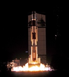
The third IRNSS satellite heads into orbit. Photo: ISRO
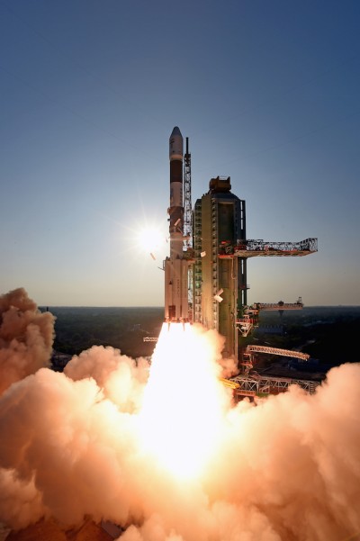
India has successfully launched IRNSS-1C, the third satellite in the Indian Regional Navigation Satellite System (IRNSS), early on October 16. The satellite was launched aboard the Polar Satellite Launch Vehicle (PSLV) C26 at 2002 GMT (4:02 p.m. EDT) from Satish Dhawan Space Centre, Sriharikota.
After the lift-off of PSLV-C26 with the ignition of the first stage, the important flight events — namely, stage and strap-on ignitions, heat-shield separation, stage and strap-on separations and satellite injection — took place as planned, according to the Indian Space Research Organization (ISRO). After a flight of about 20 minutes, 18 seconds, the IRNSS-1C satellite, weighing 1425 kg, was injected to an elliptical orbit of 282.56 km x 20,670 km, which is very close to the intended orbit.
After injection, the solar panels of IRNSS-1C were deployed automatically. ISRO’s Master Control Facility (at Hassan, Karnataka) assumed the control of the satellite. In the coming days, four orbit maneuvers will be conducted from the Master Control Facility to position the satellite in the geostationary orbit at 83 degrees East longitude.
IRNSS-1C is the third of the seven satellites constituting the space segment of the Indian Regional Navigation Satellite System. IRNSS-1A and IRNSS-1B, the first two satellites of the constellation, were successfully launched by PSLV on July 02, 2013, and April 04, 2014, respectively. Both IRNSS-1A and 1B are functioning satisfactorily from their designated geosynchronous orbital positions.
IRNSS is an independent regional navigation satellite system designed to provide position information in the Indian region and 1,500 kilometers around the Indian mainland. IRNSS will provide two types of services, namely, Standard Positioning Services (SPS) — provided to all users — and Restricted Services (RS), provided to authorized users.
A number of ground stations responsible for the generation and transmission of navigation parameters, satellite control, satellite ranging and monitoring, etc., have been established in as many as 15 locations across the country.
This is the 27th consecutively successful mission of the PSLV, which used the XL configuration of PSLV for the seventh time. Honorable Minister of State (Space) Jitendra Singh, witnessed the launch from the Mission Control Centre at SDSC, Sriharikota.
The next satellite of this constellation, IRNSS-1D, is scheduled to be launched by PSLV in the coming months. The entire IRNSS constellation of seven satellites is planned to be completed by 2015.
Below is a slideshow with images from the launch preparations and launch.
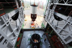
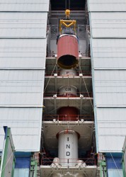
Nozzle end segment of PSLV-C26 being hoisted for assembly. Photo: ISRO
Nozzle end segment of PSLV-C26 being hoisted for assembly with launch pedestal. Photo: ISRO
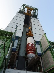
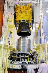
IRNSS-1C being assembled with PSLV-C26 in the mobile service tower. Photo: ISRO
PSLV-C26 inside the mobile service tower prior to satellite integration. Photo: ISRO
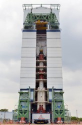
IRNSS-1C being assembled with PSLV-C26. Photo: ISRO
The PSLV-C26, carrying IRNSS-1C, lifts off. Photo: ISRO
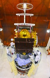
Assembly of PSLV-C26, third and fourth Stages. Photo: ISRO
The third IRNSS satellite heads into orbit. Photo: ISRO
 The Indian Space Research Organization (ISRO) and India’s Department of Space have signed a memorandum of understanding (MOU) with OPPO India to strengthen the research and development of the NavIC messaging service to provide a convenient and user-friendly platform.