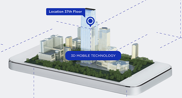
Phone users can now be located by emergency responders within one floor level inside multi-story buildings
Polaris Wireless, an innovator of high-accuracy software-based wireless location solutions, announces the company’s Z-axis location solution is commercially available nationwide.
The technology — demonstrated to meet the 3-meter vertical location accuracy requirement of the Federal Communications Commission (FCC) — is integrated into Schok Gear’s newly released flip phones.
Schok’s flip phones are typically used by consumers looking for a simple, yet powerful flip phone, that can now be accurately located in emergencies. Adding indoor and vertical location to these devices enables first responders to locate all wireless 911 callers with floor-level accuracy in multi-story buildings.
“This is a major milestone for the 911 industry to deliver FCC-compliant Z-axis emergency location technology for users of feature phones” said Manlio Allegra, CEO and Founder of Polaris Wireless. “Working with Schok and their partners has been straightforward and it’s exciting to see for the first time the complete Z-axis solution commercially available in a flip phone.”
“The Polaris Wireless location software was seamlessly integrated with our existing location and chipset vendors” said Samuel Gutiérrez, chairman and CEO, Schok, LLC. “Our Schok flip feature phone passed Tier I carrier acceptance testing, which for the first time included Z-axis location. Now our customers can be assured their accurate vertical location will enable first responders to find them faster in an emergency.”
The vertical component of wireless location is critical in today’s environment when most 911 calls are placed by mobile phones and increasingly indoors, where location determination is particularly challenging. Accurate indoor wireless location is a game-changer for first responders to quickly get to where they are needed, regardless of the phone being used by callers. The Polaris Wireless Z-axis service is available seamlessly nationwide for public safety and commercial deployments.
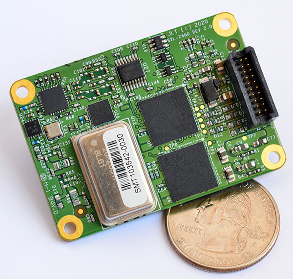
The STL-2600 STL-capable receiver provides a GNSS-independent low SWaP-C UTC-time and location capability
Jackson Labs Technologies Inc. (JLT), a designer and manufacturer of GNSS, timing and frequency equipment, has announced the availability of the STL-2600 Satellite Timing and Location (STL) receiver designed in partnership with Satelles Inc., the STL service provider.
The STL-2600 commercial receiver provides a completely GNSS-independent, low-cost capability to generate UTC nanosecond timing and meters-accurate positioning anywhere in the world. It operates in a way similar to GPS, but without GPS or GNSS. The STL signal has 30-db (1,000 times) higher power compared to GPS signals, allowing the receiver to operate deep indoors independent of any GPS/GNSS signal.
“Useful for non-GNSS-based E911 location and UTC(NIST) timing applications, the STL-2600 receiver is deployable today to fulfill critical infrastructure PNT objectives such as those outlined in Executive Order 13905 on the responsible use of PNT in the U.S. and the emerging mandates for a GNSS-independent backup solution in Europe,” said Said Jackson, president of JLT.
The STL-2600 receiver is also useful in marine applications where GNSS signals are regularly denied or manipulated and for stationary high-accuracy timing applications such as 5G.
The STL-2600 receiver can be directly connected to JLT’s GPS Transcoder products for glue-less retrofit capability of existing customer legacy GPS-only receiver systems to Galileo, GLONASS, BeiDou, QZSS and SBAS as well as adding the STL and optional atomic holdover capability to these legacy systems.
The receiver module combines a custom-designed STL L1 LEO receiver and a latest-generation concurrent-GNSS receiver with a disciplined high-stability reference oscillator sub-system on one circuit board.
Features and specifications of the STL-2600
Photo: JLT
Form factor: 1.4″ x 2.0″ x 0.5″ (36mm x 51 mm x 13mm)
Switching modes: User-selectable automatic and manual switching between GNSS and STL signal reception during jamming or manipulation events
Integration: Incorporates into user systems just like a legacy GNSS receiver would using NMEA and SCPI serial messages, with the use of standard NMEA messages for STL positioning and timing features making system integration trivially easy
Oscillator options and performance: Internal high-stability TXCO standard; capable of directly and gluelessly disciplining numerous optional DOCXO, CSAC and rubidium oscillators for holdover capability, with ultra-stable ADEV performance from 0.1s to infinity with better than 10E-12 stability when using a DOCXO or Rubidium as the holdover oscillator
Low-power consumption: Ranges between 0.7 W to 1.45 W (depending on configuration) allowing for long-term battery operation for use cases without AC power
Antenna support: One GNSS/STL combined standard; optional support of a second antenna for diversity
Interfaces: TTL serial port standard; optional USB serial port allow easy evaluation and design-in
Upgrades: One-button firmware updates performed in situ through any of the serial ports
The receiver includes JLT’s proven frequency and timing disciplining and holdover IP deeply embedded into the entire signal chain for ultra-low phase noise performance and high-stability 1PPS and 10 MHz operation, even when using only the built-in TCXO oscillator.
The unit operates fully autonomously from just a USB cable and is compatible with a customized version of the GPSCon software — offered at no cost to JLT customers — for monitoring and control.
The STL signal has been deployed worldwide since 2016 and can be evaluated and implemented SWaP-C-effectively today via this receiver module.
The STL-2600 is available now. Contact Jackson Labs Technologies for configuration and pricing information.
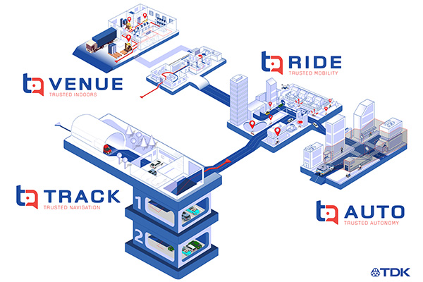
TDK Corp. has announced that Trusted Positioning Inc. (TPI), a TDK Group Company focused on creating and selling positioning software, has joined the New Business Promotion Center of TDK Corporation as an independent business unit.
With the expanding positioning and location tracking market, this move signals TDK’s commitment to developing TPI as an independent software solutions business, according to a TDK press release.
TPI has been developing integrated positioning solutions for decades, with software deployments in more than 50 million systems worldwide. The company’s innovation team is comprised of experts in inertial navigation, dynamic motion mechanics, geomagnetic positioning, GNSS, Bluetooth low energy, Wi-Fi and other wireless positioning techniques.
TPI’s inertial navigation solutions provide highly accurate positioning for the autonomous vehicle, automotive infotainment/telematics, robotics, two wheeled micro-mobility and indoor positioning markets.
VENUE (previously Coursa Venue) is TPI’s flagship indoor positioning solution based on inertial, geomagnetic and other wireless technology. The indoor positioning market is exploding with the now-ubiquitous GPS everywhere, except indoors. TPI’s indoor positioning requires minimal infrastructure investment, which reduces costs, and is well suited to scale for large venues.
RIDE is TPI’s two wheeled micro-mobility solution (previously called MML) for the burgeoning rental bike and electric scooter industry. This software solution enables the return and location identification of vehicles in urban areas where GPS is less accurate, and facilitates correct orientation of parked bikes to ensure city standards are met.
TPI’s TRACK product (previously named IPL), fuses GNSS and an IMU to provide accurate dead reckoning for automobile infotainment and telematics systems during GNSS outages in tunnels, underground parking and other sheltered areas.
TPI’s AUTO solution (previously known as Coursa Drive) improves reliability in autonomous vehicles and robots utilizing onboard radar and inertial sensors. AUTO provides all weather decimeter level positioning accuracy in urban areas with limited GPS signal availability.
With the introduction of TPI’s new structure and product names, today TPI also launches a new dedicated website: www.trustedpositioning.com.
“Relaunching our business and brand while leveraging a SaaS business model, partnering with major companies around the world and keeping them competitive, marks a strategic move for TPI”, says Chris Goodall, managing director and founder of TPI.
To prevent the further spread of COVID-19, the world is shifting to a “new normal” in which social distancing is practiced and contact between people is avoided. Due to early evidence suggesting the spread of COVID-19 is much more aggressive indoors than outdoors, many companies have begun efforts to monitor workers’ movements and trace contacts to keep offices and factories from becoming new epicenters of infection.
The Need to Monitor
Keeping a safe distance from others and avoiding contact is essential to prevent getting infected with COVID-19. However, there are many situations where avoiding contact with others at indoor locations such as offices and factories is difficult. Hence, there is a growing need for technologies that monitor contact between workers and their movement histories in real time.
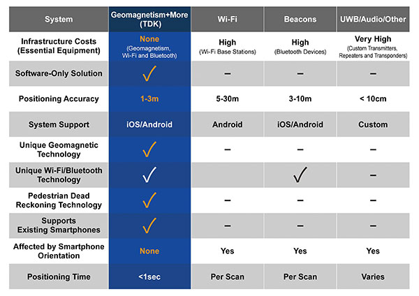
Indoor location information can be obtained using various wireless communication technologies including Wi-Fi, Bluetooth and ultra-wideband (UWB). For example, Bluetooth beacons have been deployed at commercial facilities to enable services that provide location-relevant information to customers with smartphones. The positioning accuracy of Bluetooth, however, is only around 3 to 10 meters and is dependent on infrastructure installation.
To be useful for contact tracing of infectious diseases, the number of beacons must be increased to achieve an adequate level of accuracy. UWB technology features high positioning accuracy, but deployment in a wide area would require installation of a large number of radio transceivers and repeaters, putting it at a cost disadvantage.
Solution Based on Geomagnetism
Given this background, a solution using geomagnetism is attracting attention. TDK has developed VENUE, which displays the real-time locations of people by utilizing geomagnetic sensors found in today’s smartphones. Each indoor location has a geomagnetic signature that can be used to ascertain the position of the phone.
There are several approaches to indoor positioning, but geomagnetism, tightly coupled with inertial navigation, optimally balances accuracy, reliability and cost of deployment and maintenance.
“The beauty of geomagnetic positioning is that it works in all large venues whose structures interfere with Earth’s magnetic field, making this an infrastructure-free approach to indoor positioning that is accurate to better than 2 meters,” said Chris Goodall, founder and managing director of Trusted Positioning Inc., a TDK Group Company based in Calgary, Alberta, Canada.
VENUE provides a position display with even higher accuracy by combining geomagnetic information with information from accelerometers and gyroscopic sensors inside smartphones.
VENUE requires only the creation of a geomagnetic map that combines an indoor layout map with the geomagnetic data of that particular location acquired through a survey, with no need to install new devices and terminals. This leads to low installation cost. The accuracy of positioning using geomagnetism is better than two meters (6 feet) — sufficient for tracing contact with infected persons. In addition, VENUE provides a position display with even higher accuracy by combining geomagnetic information with information from accelerometers and gyroscopic sensors inside smartphones.
“People may hold their smartphones while walking or put them in their pockets or bags,” Goodall said. “Since the orientation to the user changes constantly, the movements and pedestrian use cases need to be corrected using inertial sensors. Solving these issues was the greatest challenge for practical applications such as tracking, and took our team many years to create, perfect and protect.”
Comparison of indoor location information technologies. (Chart: Trusted Positioning)
Real-World Trial Under Way
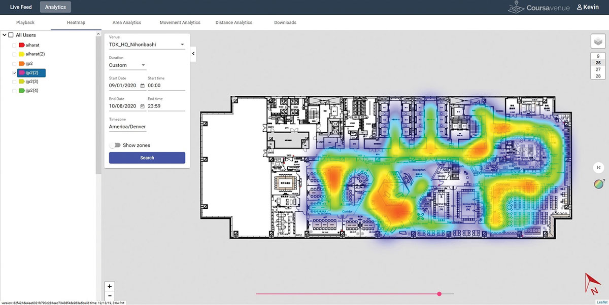
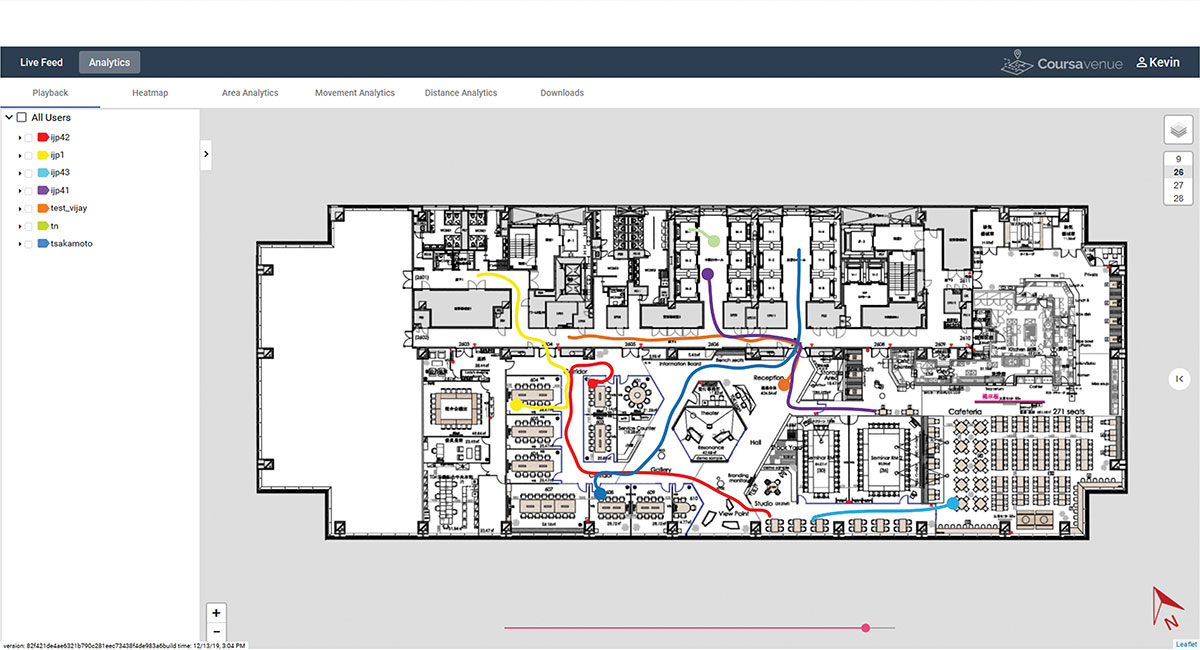
Beginning in August, a contact tracing trial among workers is being conducted at TDK’s headquarters in Nihonbashi, Tokyo, using VENUE. Employees carry smartphones with a special app installed, and their positions and movement histories on the floor are combined with anonymous identification information. If an employee is found to be infected, the data will be analyzed to identify people who had contact with that employee within the preceding two weeks, and measures such as stay-at-home instruction will be taken.
This solution not only can identify those who were in close contact with the infected person as primary contacts, but also trace those who stayed in areas where the infected person had been shortly before as potential “area contacts.” Analysis that combines location and elapsed time enables more effective contact tracing by improving primary contact tracing indoors and enabling area-based contact tracing over time.
Ongoing Trial at TDK Headquarters: VENUE displays an individual worker’s tracking data on the dashboard. (Conceptual illustration: Trusted Positioning)Ongoing Trial at TDK Headquarters: A worker’s durations of stay and positions can be visualized in the form of a heat map. (Conceptual illustration: Trusted Positioning)
New Possibilities Opened
Because VENUE can display the positions and histories of people and objects using not only workers’ smartphones but special tags containing geomagnetic and inertial sensors (under development), it can be deployed for a wide range of applications beyond contact-tracing of infectious diseases. Possible uses include monitoring the flow of employees to improve operational efficiency or tracking positions of equipment to manage their operational statuses. TDK is working with a number of companies on solutions to improve business efficiencies using location information.
Many offices have introduced open seating, so maintaining a “real-time seating chart” using VENUE is a real advantage so staff can more easily find one another in large office settings, encouraging more collaboration between staff and departments.
Companies have been using Bluetooth low-energy (BLE) beacons to manage the movement of workers, materials and equipment indoors in warehouses, factories and construction sites. VENUE can reduce the installation and maintenance costs of such systems, especially in large-scale facilities.
VENUE is also useful for other contact-tracing applications that do not focus on viral transmission, such as human-to-machine, human-to-vehicle and human-to-robot contacts. The future work environment will undoubtedly change with more automation, and the interaction of humans and machines poses safety concerns. VENUE’s designers hope it can improve safety in many types of contact-tracing applications.
Similar to the expansion of GPS for outdoor positioning applications, indoor positioning technologies will likely grow in our everyday lives. VENUE is one indoor location information solution that enables highly accurate location information to be obtained while keeping infrastructure costs down.
The European Space Agency (ESA) has launched a call for proposals to demonstrate the capabilities of new 5G cellular networks to support positioning and timing applications to complement satellite navigation.
5G will bring higher speed, larger traffic capacity and ultra low-latency (or signal delay) communications. 5G will also usher in a range of new possibilities for positioning, navigation and timing (PNT).
ESA is inviting proposals to implement pilot projects to demonstrate the viability of 5G PNT solutions in a number of use cases:
Indoor PNT for Industry 4.0, as needed to support the operations of smart warehouses and factories or smart city applications requiring transition from indoor to outdoor environments.
Outdoor applications where a robust back-up to satellite navigation is essential to meet safety requirements, such as autonomous driving or drone navigation.
Applications where robust time and frequency synchronization is necessary, both in outdoor as well as indoor environments, like smart energy grids or the 5G networks themselves.
5G networks will allow new types of measurements made possible by advanced antennas and by new positioning signals at higher frequencies, at both base stations and the user receivers. 5G networks will also bring enhanced connectivity to improve cloud-based positioning applications and value-added services.
While satellite navigation works optimally in outdoor environments with a wide view of the sky, 5G PNT has the potential to bring PNT to deep urban canyons in high-rise city centers and indoor warehouses, wherever 5G networks are deployed.
The combination of satellite navigation and 5G brings the promise of high performance, secure and resilient PNT services, as well as a seamless application of PNT applications from outdoor to indoor environments and from rural to urban areas, ESA said.
This call for ideas is supported through ESA’s Navigation Innovation and Support Programme (NAVISP), working with European industry and academia to develop innovative navigation technology.
Webinar on PNT 5G
To support the call, an information webinar is being held on 21 October, in which the various PNT 5G use cases will be presented by key speakers from each sector. Details of the call and how to apply will also be presented by ESA.
A networking platform has also been established to allow webinar participants and general stakeholders interested in the call to get in touch and discuss possible cooperation. This platform will be kept open during the entire period of the call’s duration.
For more information on the call and the agenda of the webinar visit ESA’s NAVISP website.
To register for the webinar and the networking platform, click here.
Indoor location platform provides municipalities with emergency response and public safety solutions on existing Wi-Fi networks
InnerSpace, a Toronto-based company, is offering its Wi-Fi-based indoor location intelligence platform to support all levels of government. The platform analyzes patterns and movement in public spaces using existing Wi-Fi networks.
The platform is suitable for understanding the movement of people inside public spaces and can support emergency response strategies, social distancing programs and help smart cities implement effective security and public safety measures.
“In response to the global COVID-19 pandemic, we have accelerated the delivery of our public safety solution inFORCE,” said James Wu, CEO, InnerSpace. “Our platform processes RSSI [received signal strength indication] data in real time and returns the industry’s most accurate location data available today. By using public Wi-Fi access points, municipalities have a way to quickly roll out new solutions at city-wide scale.”
InnerSpace inFORCE was selected in a competitive process by the U.S. Department of Homeland Security, for its ability to use Wi-Fi to locate citizens and track emergency responders in an active shooter scenario.
The same platform can be used in a wide variety of emergency situations such as the current COVID-19 pandemic. In addition to the company’s tracking capabilities, it’s analytics dashboard gives public safety offices an unprecedented view into how people leverage public spaces.
“In times of emergency, it is reasonable to prioritize safety and public health to minimize the loss of human life,” said Cerys Goodall, president and COO, InnerSpace. “By providing municipalities with a system that can deliver line-of-sight into how people move in public spaces, we can inform response strategies, improve rescue efforts, and create an infrastructure to support better outcomes.”
InnerSpace inFORCE ingests RSSI data and returns accurate anonymous indoor locations. The information can be connected directly into emergency response communications systems, building management and security systems, or analyzed by InnerSpace to identify critical patterns and trends in people’s movements.
Sewio — a UWB-based, real-time location system (RTLS) company — is offering companies free consulting and software licenses to help them install employee tracking technology.
Current quarantining and other enforced measures are designed to save lives by containing the spread of the virus. Once these restrictions are lifted, the pressure to restart manufacturing operations will increase.
Nevertheless, this brings the risk of a COVID-19-positive employee introducing the virus to the workplace, increasing the risk of infecting colleagues, endangering lives and placing the factory under quarantine again.
With its precise accuracy, ultra-wideband RTLS enables employee tracking and monitoring of any employee who has come into contact with a newly identified infected person. According to Sewio, it can help make sure exposed staff members are tested and receive the treatment they need as quickly as possible.
“UWB-RTLS-powered smarter, faster and selective quarantining helps save lives and keep mission-critical operations running at all times,” said Milan Simek, CEO at Sewio Networks.
The dashboard shows how Ubihere tracks with both camera and tag technology. (Screenshot: Ohio Development Services Agency)
Ubihere has introduced a new 2D and 3D tracking technology for indoor and outdoor positioning.
Ubihere’s patented technology provides real-time asset location and information without GPS, making it an alternative for GPS-denied environments.
From Space Walks to Retail Stores
The inventor of the technology is geoinformatics professor Alper Yilmaz of The Ohio State University (OSU), who researched how to geolocate undercover officers based on motion video information, as well as astronauts on space walks.
OSU urged Yilmaz to commercialize his technology, and Rev1 Ventures served as the incubator. Ubihere launched under Rev1’s portfolio in 2016 in Columbus, Ohio.
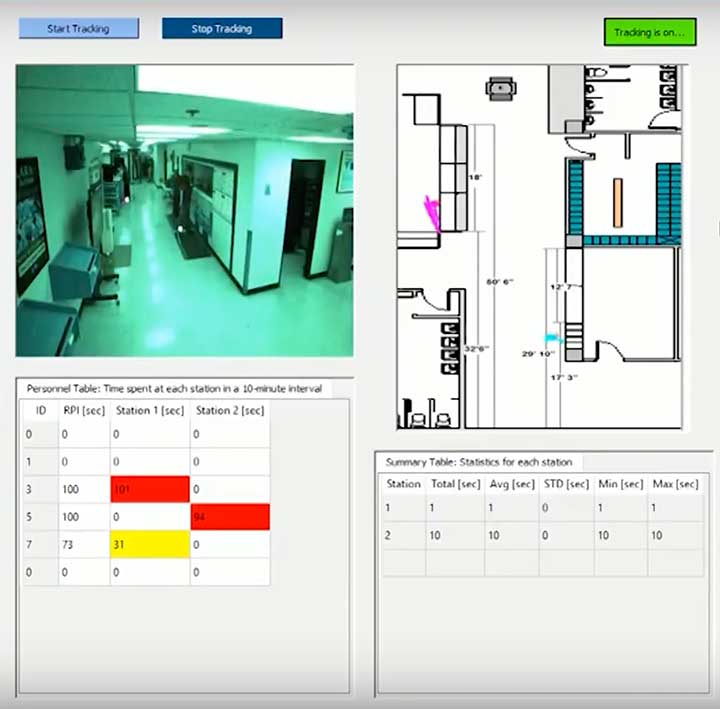
Ubihere’s system is based on anonymous video analysis positioning technology, which is patented from OSU, coupled with tag technology and advanced machine learning analytics. The system’s tags, cameras, and software track assets to the centimeter. The assets are monitored through an anonymous video feed or the tags themselves, which are about the size of a credit card, and non-RFID.
The map for indoor environments can be generated from a building information model (BIM). Based on the building’s architecture, movement is tracked. In milliseconds it can hone in on an exact location within a centimeter, explained Alice Hilliard, Ubihere’s vice president of business development.
The location data is transmitted to a server or the cloud, depending on the customer’s preference. It is then loaded into dashboards that can be accessed from any device the client requests.
If a tagged object leaves a building, it will continue to be tracked with or without GPS. If the object stays within the building, it will never use GPS. Using GPS shortens the battery life, which ranges from 18 to 24 months. Battery life is also affected by the number of floors, temperature and usage.
Launching in Hospitals and Retail Stores
The tag offers a way to calibrate location in places such as hospitals, where tracking food carts or devices through lead-lined walls enables hospitals to maximize their efficiency.
“Imagine how many times a nurse or other caregivers go back and forth,” Hilliard said. “By tracking how people and objects move around, we can help departments figure out opportunities to lay out the floor better to allow the staff to save time and steps.
“With a blueprint loaded into the software,” Hilliard said, “the system knows whether a (tagged) IV pump went down the hall, turned left or right, entered an elevator, or was left in a patient’s room.”
The cameras can be installed in locations such as retail stores, enabling Ubihere to anonymously track a customer’s journey. Used together, the tag and camera can help stores determine whether a display is working, showing how many customers came in to shop, or how many looked at or touched items in a particular display.
For ecommerce, customer behavior can be tracked automatically in real time with Google Analytics and other SEO tools.
Other possible uses include factories and emergency-response teams. “If you were in a factory or even a nuclear power plant, OSHA guidelines establish that you have to have two people in the control room at all times,” explained Hilliard.
“Periodically, OSHA is required to monitor if the power plant is following that protocol. Instead of having someone sit there and oversee the situation, we can use our camera technology to anonymously collect workers’ whereabouts, which can then be easily pulled from the cloud. For response teams, an equipment failure that makes it difficult to locate a team member could be overcome with the tag technology. “
Ubihere’s machine-based algorithms can learn locations based on various types of sensors, Yilmaz said, adding that detecting odors isn’t out of the question.
The startup is now exploring potential applications of its GPS-free tracking technology. While initially focusing on beta tests in hospital and retail environments, Ubihere also has three projects with the U.S. Department of Defense.
Orion Labs has released Advanced Location Services, a high-accuracy, carrier-independent 3D location platform delivered via Polaris Wireless.
The service provides enterprises and public safety agencies with pinpoint location, indoors and in high-rise buildings, with floor-level and room-level accuracy, a difficult challenge in such GPS-denied environments.
Orion indoor location example (Screenshot: Orion Labs)
The system enables customers to locate team members on the vertical axis accurate to three meters’ distance, to keep teams better-informed and better-connected, enhance team performance and improve worker safety. It works via Orion Sync, a standalone smart walkie-talkie, or as device as a service, in a smartphone form factor.
“For our hospitality and retail customers, this offers the opportunity to greatly improve guest services and the experience they deliver. For public safety and healthcare customers, the integration has the potential to save lives,” said Jesse Robbins, founder and CEO.
According to co-founder and CTO Greg Albrecht, “With 3D location tracking, hospitality teams can easily pinpoint where their guest service workers are located and identify the right team member for faster guest response for tasks like bringing up clean towels to a guest, fixing a TV or lightbulb in a guestroom, or clearing trays and carts,” he said.
The system also protects lone workers. “When lone workers call for help, security teams can rapidly dispatch assistance without the lone worker needing to explain their location,” Albrecht said. “This is the same kind of technology that first responders are now adopting to accurately and rapidly locate 911 callers facing life-threatening situations.”
Hotel workers suffer work-related incidents at a nearly 50% higher rate than other industries. (Photo: Dean Drobot/Shutterstock.com)
Hotel workers suffer work-related incidents, encompassing physical injuries, medical emergencies, theft and sexual harassment, nearly 50 percent more than is the average across all other industries. Large metropolitan hotels can approximate small cities, with as many as 5,000 rooms, 12,000 guests, and 8,000 employees. Even a moderate-sized hotel can have hundreds of employees scattered across many floors, some remote from central operations. Locating employees quickly is key to preventing or minimizing incidents.
Need maps. A fundamental challenge in developing 3D location awareness indoors is the need for accurate, detailed 3D renderings of the physical buildings themselves.
“For most buildings, this has never been done before and is often an arduous task to accomplish,” Albrecht added. “However, there is a mapping process to allow for precise data points to be leveraged within the Orion platform. It’s a very simple task that can be completed even by the hotel staff at the time of setup. After that, it’s extremely simple to set up teams within the Orion System with a 3D view of their property that they can use.”
The latest integration is undergoing tests at locations in Las Vegas and San Francisco, with more than 50 locations actively using the set-up.
Polaris Wireless, a provider of software-based wireless location solutions, announced the commercial availability of a high-accuracy carrier-independent 3D location platform for application developers. By integrating their applications to the new platform, developers can provide end users with pinpoint location, including indoors and in high-rise buildings with floor level accuracy, delivering enhanced situational awareness and improved operational efficiency, according to the company.
Polaris Wireless has integrated its new platform with Orion Labs, Inc., a San Francisco-based company delivering instant and secure voice and location communication.
The Polaris Wireless 3D location platform is cloud-based and is available to application developers via a standard Android and iOS SDK. It can locate devices on the vertical axis within 3 meters, floor level, utilizing all available signals and sensor measurements combined with the company’s patented algorithms. By operating independently, or “over the top,” of wireless carrier networks, the platform is “universal,” enabling applications to locate any device on any network.
“Orion’s customers in hospitality, retail, healthcare, and public safety require pinpoint accuracy on a person’s location inside a building. Polaris Wireless’ platform helps us deliver that location capability, both for teams to see which floor they’re on or room they’re in, as well as to integrate location awareness with Orion Voice Bots and advanced AI-driven services,” said Jesse Robbins, Founder and CEO of Orion Labs.
Orion will demonstrate its solution based on the Polaris Wireless 3D location platform at the International Wireless Communications Expo (IWCE) in Las Vegas March 4-8 in booth No. 3371.
Polaris Wireless CEO, Manlio Allegra, will be participating in an IWCE panel titled “Impact of Enhanced Location Accuracy on Public Safety and 911 Services” on Wednesday, March 6 at 11:45 a.m.
Bluetooth has added a new direction-finding feature to help meet the growing demands of the location services market.
The feature, which allows devices to determine the direction of a Bluetooth signal, was added to Bluetooth in version 5.1 of the Bluetooth Core Specification, released Jan. 28.
To make use of the direction-finding feature, Silicon Labs has released new software for the Wireless Gecko portfolio, a comprehensive connectivity solution for the internet of things (IoT).
Silicon Labs’ commercial, industrial and retail customers can enhance their location-based services — indoor navigation, asset tracking, space utilization and point-of-interest engagement — using the direction-finding feature, the company said.
The new feature supports multiple methods for determining signal direction including angle-of-arrival (AoA) and angle-of-departure (AoD).
Silicon Labs’ implementation of the new Bluetooth feature enables detection of signal direction within 5 degrees.
To date, Bluetooth asset tracking and indoor positioning solutions have typically provided location accuracy within a range of 3-4 meters. With the Silicon Labs Bluetooth 5.1 solution, developers can create products that improve location accuracy down to the sub-1-meter level, opening the door to applications previously not possible.
“The Silicon Labs Bluetooth direction finding solution provides a huge leap in location services accuracy for the industry,” said Matt Johnson, senior vice president and general manager of IoT products at Silicon Labs. “The combination of the Silicon Labs wireless solution and the new features added in Bluetooth 5.1 will help developers transform industries and improve people’s lives.”
In addition to improved location services, Bluetooth 5.1 also helps developers:
reduce power consumption with sleep clock accuracy updates.
improve smart home connection performance using GATT caching functionality.
optimize beaconing for Bluetooth mesh in crowded RF environments with the advertisement channel index feature.
“The Bluetooth community continues to find ways to meet evolving market needs and open new opportunities,” said Mark Powell, Bluetooth SIG executive director. “The addition of Bluetooth direction finding demonstrates this commitment to drive innovation and support the incredible growth opportunity within the location services market.”
Silicon Labs’ direction-finding software, including support for the AoA method, is available to customers through the Silicon Labs Simplicity Studio development kit.
Recent changes in hardware and standards make one-meter accuracy possible, in some cases as soon as this year. The transcript of a talk given to Android developers earlier this year, this article gives a short overview of location in smartphones, introduces Wi-Fi round-trip time technology and standards, and then explains the Wi-Fi application programming interfaces.
ByFrank van Diggelen, Roy Want and Wei Wang, Android Location, Google
Image: GPS World; outdoor, Andriy Solovyov/Shutterstock.com; indoor, Rade Kovac/Shutterstock.com
It’s a great time for location applications because technology hardware standards and Android application programming interfaces (APIs) are all evolving simultaneously to enable an improved location accuracy that has not previously been possible when using smartphones.
Eventually, this means high accuracy for everyone, but we want to take you under the hood of location because we want to give you the opportunity to get a head start on the future. We also want to highlight the need to protect and respect the user. The more people who use location, the more careful we and you have to be. We will highlight where you must get user permissions and we’ll close with some guidelines for making great location apps.
Where are we today with indoor location accuracy? If you’ve noticed that your phone seems to be more accurate when you’re inside shopping malls and office blocks than it was a few years ago, you’re not imagining it. With each release of the fused location provider, we have had steady improvement of the Android algorithms and machine learning for Wi-Fi locations.
There continues to be improvement, and you’ll see indoor accuracy of better than 10 meters, but round-trip time (RTT) is the technology that will take us to the one-meter level.
Meanwhile, what about GPS? In terms of GPS accuracy in the open sky, there has not been much change in the last few years. If you’re outside and can see the open sky, the GPS accuracy from your phone is about five meters, and that’s been constant for a while. But with raw GNSS measurements from the phones, this can now improve, and with changes in satellite and receiver hardware, the improvements can be dramatic.
Everyone’s familiar with the blue dot, but to get the blue dot you need a location provider, and to get location you need measurements — specifically, range measurements from Wi-Fi access points or from GPS satellites. We’ll show you how one-meter measurement accuracy can be made available in smartphones. The key technologies are Wi-Fi RTT, GPS dual-frequency and carrier phase measurements.
If you want to wait a year or two, this will find its way into the worldwide ecosystem and the Android fused location provider API, but we want to give you a chance for a one- to two-year lead by taking accurate measurements and turning them into accurate location. We want to work with you to accelerate development and bring the present closer to the future.
You might wonder, why do I need better location accuracy anyway? Let’s look at two instances where existing apps could use much better location accuracy.
For indoor routing or navigation of the kind that you’re used to in your cars, you need much better accuracy than you have outdoors: you need one-meter accuracy, because indoor features like cubes or aisles are only a few meters wide. Even for the most loved outdoor applications such as map directions and finding alternate routes in traffic, we could benefit from higher accuracy than we have now.
For example, when you came here this morning in a car, you probably had your arrival time estimated using the average speed of the traffic. What you really want is the traffic speed in the lane that you’re in, so that you could ask, how much faster would it be if I took the carpool lane instead? There are, of course, many other use cases and we’ll mention a few. But the important thing is that we are sure that you will have many more ideas than we have, and that’s the beauty of the open Android ecosystem.
Wi-Fi Round-Trip Time
Wi-Fi RTT ranging and indoor position estimation is based on making measurements of the time of flight of RF signals, and can be used to estimate your indoor position to an accuracy of one to two meters.
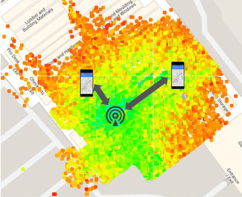
Before we get into the details of Wi-Fi RTT, we want to tell you how we currently calculate an indoor location. At this time, we use Wi-Fi received signal strength indication (RSSI). Basically, we can calculate distance as a function of signal strength. Figure 1, with the access point in the center, shows a heat map of the signal strength around a Wi-Fi access point (AP).
Figure 1. Wi-Fi receive signal strength indication (RSSI) non-isotropic signal propagation. (Image: Frank van Diggelen, Roy Want and Wei Wang)Figure 2. Wi-Fi RTT principles, basic concept.(Image: Frank van Diggelen, Roy Want and Wei Wang)Figure 3. Wi-Fi RTT principles in practice. (Image: authors)
The green is the strongest signal, near the AP and the red is the weakest, measured toward the edges. I’ve placed two phones on this diagram at the transition between the weak and the strong. Notice that the phone on the right is further away from the access point than the phone on the left. The signal strength can therefore vary at the same distance, which unfortunately makes it very hard to make accurate range measurements based on this type of measurement. There are lots of algorithms and tricks that can be used to improve this, but the greatest improvement can be achieved using a new Wi-Fi technology.
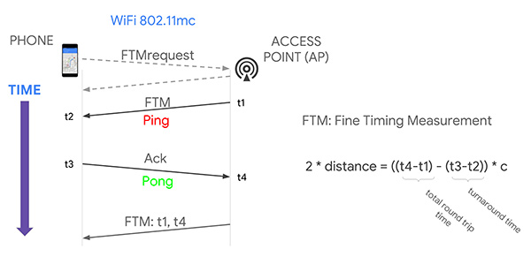
That’s where Wi-Fi RTT comes into play. It uses time-of-flight instead of signal strength. It measures the time it takes to send a Wi-Fi RF packet from an access point to a phone and back again. Because radio signals travel at the same speed as visible light, if we multiply the total round-trip time of a Wi-Fi packet by the speed of light and divide by two, we get distance, and therefore the range from the phone to the access point. That’s the basic principle.
If you want to use several ranges to nearby access points to calculate your position, we have to use a process called multi-lateration. The key thing to think about here is that the more ranges you have, the more accurate the position you can estimate. If you can use at least four ranges, then we think you can achieve a location accuracy of about one to two meters in most buildings.
Why are we telling you about Wi-Fi RTT today? Why not last year or before? Because 2018 is the year of Wi-Fi RTT in Android. We are releasing a public API in Android P based on the IEEE 802.11mc ranging protocol. Furthermore, we’re also integrating aspects of this protocol into the fused location provider, which is the main location API that developers use to put a blue dot on a map. So, in the near future, any time there are RTT access points in the vicinity of a phone, the estimated position accuracy will be greater.
History. The 802.11 standard was ratified in December 2016, and in early 2017 the Wi-Fi Alliance started an interop program for silicon vendors to make sure the chips followed the protocol. That’s when we started doing a lot of work to validate its operation and understand how it could be integrated into Android. By the fall of this year, we will release the public API so that you can all have access to this capability and can build your own applications around the technology.
Principles of Wi-Fi RTT Operation
The ranging process starts with a standard Wi-Fi scan. The phone discovers the access points that are nearby, and, based on certain bits in information elements (IEs) contained in the Wi-Fi beacons and the probe responses, we can figure out which of those access points are RTT-capable, and the phone can choose one of them to range to. It starts by making a request to the access point; as a result, the access point will start a ping-pong protocol in response. The ping sent to the phone is called a fine timing measurement (FTM) packet, and the pong sent back to the access point is an acknowledgment of that packet.
The arrival and departure time stamps are recorded at each end of the transaction, but for the phone to calculate the total round-trip time, it needs to have all four of those times. So the access point sends one more packet to the phone, and this third message contains the missing times. The phone then simply calculates the round-trip time by subtracting the time stamps from the AP, and subtracting its own packet turnaround timestamps. The difference between these times leaves just the packet time-of-flight. We multiply this by the speed of light to get distance, and divide by two to get the range that we are trying to measure.
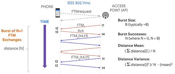
Now, it turns out if you execute this process multiple times, you will in fact get more accuracy, and so that’s what the protocol allows for, enabling a burst of FTM packets. We’re typically doing a burst of about eight of these of these transactions and, as a consequence, the system can calculate ranging statistics, such as the mean and the variance. This allows us to more accurately plot a position on a map, and knowing the accuracy also allows us to more easily calculate a trajectory.
Now that you have ranges, how do you get a position? One way, similar to GPS positioning, is you take four ranges to four separate access points; if those ranges were accurate, they would define four circles that would intersect at a single point. In practice, because of error in each range, a maximum likelihood position is calculated using a least squares multilateration algorithm.
You can then further refine this position by repeating the process, particularly as the phone moves, and then calculate trajectory using filtering techniques, such as Kalman filtering, to optimize the estimate.
Like any new technology, there are challenges, and we’ve experienced some of these early on. What we find is that sometimes there is a constant range calibration offset that may be as much as half a meter. Sometimes you also see multipath effects where a packet on the non-line-of-sight path from the access point to the phone is received rather than on the line-of-sight path, making the range appear longer. That problem can be solved by the vendor using something called antenna diversity, but all of these issues are related to algorithms, which the vendors are improving.
Basically, we need to go through a sort of teething process to get rid of these bugs, and Google can help in this process by providing reference platforms and reference applications. Vendors can then calibrate their own platforms before you guys even get to use them, which will be the ideal situation.
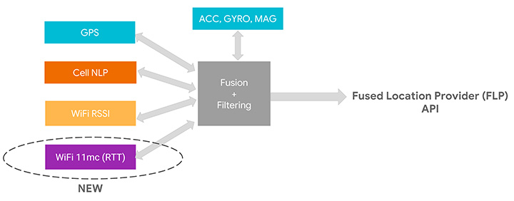
We’ve assumed that as early adopters you want to start using this API, but as we move into the relatively near future, we expect you to just use the Fused Location Provider because we’re going to be integrating the RTT capability into it. At the moment, the Fused Location Provider uses GPS (when it’s available), cell-tower signal strength and Wi-Fi RSSI, and fuses all this with the onboard sensors: inertial navigation from the accelerometer, gyro and compass. Now we’re adding Wi-Fi RTT into that mix, and it will increase the accuracy of the Fused Location Provider whenever RTT-capable access points are available nearby.
One other thing to remember is that if you are calculating the Wi-Fi RTT position yourself, you also had to know the position of the access points. In the Fused Location Provider, we will calculate those positions for you automatically: we’ll crowd-source those positions so you won’t have to worry about that, and it will make life a lot easier for you to write applications.
RTT APIs
Let’s walk you through the RTT APIs in P to see how you can add RTT in your own application. As we mentioned, RTT measures the round-trip time between two Wi-Fi devices so both your mobile phone and your access points need to support the 802.11mc protocol. As you saw, RTT can give you very fine location estimates down to one-meter accuracy, so your application needs to declare the ACCESS_FINE_LOCATION permission. Of course, both location and Wi-Fi scanning need to be enabled on the mobile device.
How do you know whether your mobile phone supports RTT? In P, we added a new system feature called FEATURE_WIFI_RTT so you can simply check whether this returns true on your mobile device. Our pixel phones running P DP2, and above, will support RTT. How do you know whether your access points support RTT? As usual, you will need to do a Wi-Fi scan and get a list of Wi-Fi scan results. Then iterate through the scan results and check for each scan result whether the method is80211mcRepsonder() returns true. This will tell you whether the access points support RTT.
After you get a list of RTT-enabled APs, simply add them to the ScanRequest Builder to build a scan request. RTT is carried out by the WiFiRTTManager, which you can get access to by getting the system service WIFI_RTT_RANGING_SERVICE. Now we’re ready to start RTT ranging by sending the RTT request to the RTTManager with a ranging result callback. Usually RTT takes only a few hundreds of milliseconds, and when it finishes, you will get a list of information including the status — an RTT may fail, the MAC address — which AP you have just ranged, and most importantly, the distance between the mobile phone and the access point.
Here is the list of information you can get from RTT ranging results: the distance, the distance standard deviation, which is the standard deviation from multiple ranges in multiple FTMs, and the number of attempted FTM measurements and number of successful measurements. The ratio of successful measurements over attempted measurements will give you an idea of how good the Wi-Fi environment is for RTT ranging.
We mentioned all Pixel devices support RTT. How about access points? We are beginning to see access points supporting the 11mc protocol in production. We are also very excited to let you know Google Wi-Fi will soon support the 11mc protocol. By the end of this year, off-the-shelf Google Wi-Fi will have RTT enabled by default. Worldwide, we’re also beginning to see the deployment of RTT APs. South Korea is actually leading the deployment of RTT APs.
Of course, this is just the beginning of the long journey. We’re very eager to see a larger penetration rate of RTT APs in the coming years.
Figure 4. Integrating RTT with Android location.(Image: Frank van Diggelen, Roy Want and Wei Wang)
GPS and the Great Outdoors
Carrier-phase precision has been in commercial GPS receivers since the 1980s. What is new is the availability of these carrier-phase measurements from phones and dual-frequency measurements in phones. Right now, all of your smart phones, all smart phones everywhere, have GPS or GNSS on one frequency band only. It’s known as L1. But there’s a new frequency in town called L5, and it’s supported by all these GNSS systems: GPS, Galileo, BeiDou QZSS and IRNSS. The availability of a second frequency means that you get much faster convergence to carrier-phase accuracy.
What about hardware? In the last few months, several companies that produce consumer GPS chips have announced the availability of dual-frequency L1/L5 GPS chips both for the automobile market and for the phone market. These chips are now being designed into cars and phones.
Let’s talk about the measurements themselves and the APIs. The phone must support the GNSS measurements API. Your app is going to need the ACCESS_FINE_LOCATION permission, and location needs to be on.
How do you know if a particular phone supports these measurements? At a high level, you can just go to a website that we maintain, g.co/GNSSTools, as part of the Android developer site. A table there lists phones that support the GNSS measurements and also which characteristics they support. It’ll tell you which phones support the measurements and which of those support the carrier-phase measurements.
Programmatically, you do this as follows: You call the method onStatusChanged and it will return an integer that tells you the capability of the phone, either if the phone just does not support the measurements at all or if it supports it but location is off, or if it supports it and location is on; in that case, you’re good to go.
Let’s get into some details of the APIs. The most relevant methods for what we’re talking about here are the following three:
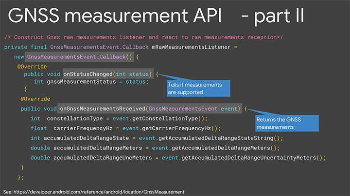
getConstellationType() tells you which of the different GNSS constellations a particular satellite belongs to.
getCarrierFrequencyHz() tells you whether you’re on the L1 or the L5 band for a particular signal.
Most importantly,
getAccumulatedDeltaRangeMeters() tells how far along that carrier wave the receiver has tracked you since it began tracking the signal.
There’s something else that we need to explain, which is duty cycling. Right now when you’re navigating with your phone and you see the blue dot moving along, you might think that the GPS is on continuously. It’s actually not. What’s happening in the phone is that GPS will, by default, be on for a fraction of a second and then off for the remaining fraction of a second, and then repeat. This is to save battery. You perceive that the GPS is on all the time because the blue dot will move along continually, but actually it’s duty cycling internally.
For this carrier-phase processing, you have to continually track the carrier wave because the carrier wave is like a finely graduated ruler or tape measure with no numbers on it. So if the GPS was on and your receiver measured your phase and you get the data from the reference station, you’d start processing. If the GPS then goes off for a fraction of a second, you’ve lost where you were. It’ll start again, you’ll reacquire, you’ll be at a different phase on the reacquisition, you’ll start again — well, you’ll never solve the problem. You need the tape measure to stay out and you need to process, and to do that you need to disable duty cycling. You can do that in Android P with a developer option.
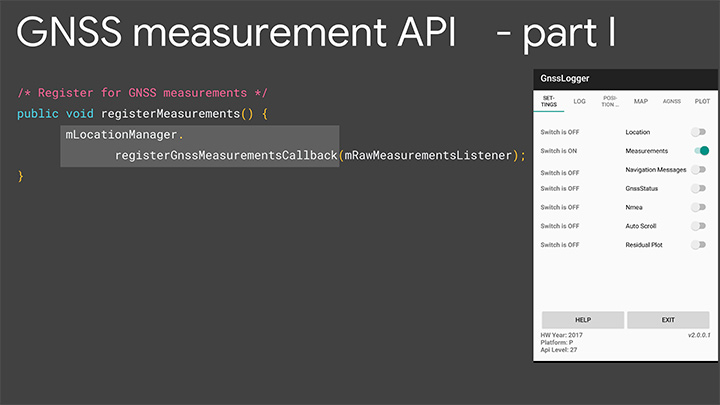
Details of the API. Figures 5 and 6 are screenshots of an application that we’ve put out called GNSS Logger. This enables you to log the raw measurements in the phone. The nice thing about this app is it’s a reference app: the code is open source and available to you on Github, so when you build your app, please make use of our code.
Figure 5. Screenshot of GNSS Logger. (Image: Frank van Diggelen, Roy Want and Wei Wang)Figure 6. Sample code for getting GNSS raw measurements. (Image: Frank van Diggelen, Roy Want and Wei Wang)
When you build an app that needs raw measurement, you will need the Android location manager API with the method registerGnssMeasurementsCallback. This method requires you to pass it a GnssMeasurementsEvent callback shown here. You construct this callback, and then override the method onStatusChanged, and that will give you the integer status that we discussed to tell you if measurements are supported.
If they are, you then override the method onGnssMeasurementsReceived, and this allows you to receive a GnssMeasurementEvent every epoch, for example, every second. This event gives you the values we’ve been talking about: constellation type, carrier frequency and accumulated Delta range. For duty cycling, that’s a developer option, so you access that through the developer page on your phone as you see there on P. This allows you to disable the duty cycling.
Keep in mind this introduces a trade-off between getting the continuous measurements and battery life. There will be an impact on battery life. How much? Well even when GPS is on continually, it will use less than 20% of the power that screen-on uses, so that gives you a feel for the magnitude. This is a developer option precisely because it’s a trade-off involving battery life, and we’re very concerned about maximizing battery life, but if you and our team together can prove that there’s value in this option and people want it, then it will be upgraded to a fully supported API in the future.
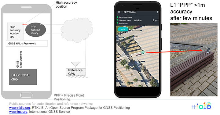
Figure 7 shows the basic architecture that we expect if you implement an app for high accuracy. On the bottom of the block diagram on the left you’ve got the GPS/GNSS chip. The GNSS measurements come up through the APIs we’ve just described, and then your app lives at the top in the application layer. You’re going to need access to a reference network to get the data that the reference stations are tracking. There are publicly available reference networks. I’ve listed one at the bottom: the International GNSS Service. You can get data from them free.
Figure 7. Apps for high-accuracy GPS.(Image: Frank van Diggelen, Roy Want and Wei Wang)
Then you need to process that data in some kind of position library, and that does all the carrier-phase processing, and that too is available as open-source code. RTKLib.com has an open-source package for precise positioning. Then you’re good to go.
We mentioned that dual frequency gives you much faster convergence to the high accuracy, but you don’t have to wait until the dual-frequency phones come out. You can start doing this with single-frequency phones. Here’s an example of someone who’s already done that. This is an app created by the French Space Agency, and they’re doing exactly what we show on the block diagram on the left and they’re achieving sub-meter accuracy after a few minutes of convergence.
Here’s some more external analysis that’s been done in a similar way. This is from a paper called “Positioning with Android GNSS.” This is using one of those chips that we showed you, the chip that goes in cell phones that does dual frequency. What’s been shown here is the cumulative results over many different starts of the GPS and what you see is that most of the time the accuracy is better than a meter. You see that on the vertical axis, which is 0 to 1 meters, the accuracy gets to better than a meter in less than one minute and then continues to converge as long as the phone continues to track that carrier phase continuously.
Here’s a another similar but different paper. This is using one of the chips that’s meant for cars. This was tested in a car driving around that track there, and what the plot here shows is the accuracy after the initial convergence while the car was driving. You see with GNSS alone the accuracy is 1 to 2 meters, and with this carrier-phase processing it’s at a couple of decimeters.
For you to build this, what are you going to need? Of course you need the device location to be enabled and your app has to have location permissions, so that’s going to come from the user. You need the basic GNSS measurements, that’s been available since Android N. You also need this continuous carrier phase I’ve been talking about and that’s available in P with the developer option. It would be nice to have dual frequency for fast convergence and that’s coming soon. You need a reference network such as the one we already mentioned; there are also commercial reference networks out there and commercially available software to do the same thing, but we recommend you start with the free stuff and go from there.
Finally there’s the app from you.
In summary, everything we’ve been showing you here is based on indoor and outdoor technology that’s been evolving kind of in parallel. In each case we have a new technology and Android P gives you a way to access it.
Indoors Again
The new technology is Wi-Fi RTT and round-trip time-enabled access points. We give you a public API to access these measurements, but you need access point infrastructure. This is where some of you can move ahead this year, because if you have a customer who owns or controls a venue, they can upgrade their access points — sometimes just a firmware upgrade — and then you have the infrastructure. Android P comes out later this year, and you can implement something and have indoor navigation, or create any other type of context-aware app.
For example, someone goes in a store: where’s the milk? You can make the world a better place for all of us by saving us from the tyranny of having to ask directions from strangers. And if you’re not one of those people who has access to this now, in a few years the infrastructure will naturally evolve as access points upgrade to RTT, and one-meter location will be automatically available from the Fused Location Provider.
Now Outdoors
For this carrier-phase process, it’s not just outdoors, but outdoors with open sky. What do you need? Dual frequency and continuous carrier phase. We give you the API and the developer option to make use of that. You will need reference-station access as we mentioned, and then applications.
What can you do outdoors with open sky? We already mentioned the traffic example. There are many others that readily come to mind where existing GPS accuracy doesn’t cut it. For example geocaching, where people look for treasures; it would be nice to have one-meter accuracy. Precision sports monitoring. Imagine a snowboarder who wants to measure her tracks very precisely after the fact. Five-meter location is not good enough. One meter would be great.
Speaking of sports, there are more and more drone apps where you have a kind of “follow me” capability, and the drone will fly along and video you. Well it would be nice if it videos you and not the person next to you. And so on. There are hundreds of apps, and you’re probably thinking of some right now, and that’s the whole point.
We want you to write those apps, and together we’ll bend the arc of technology history closer to the present. I’m really looking forward to next year to see you back here and see what you’ve created.
Finally, we want to leave you with a couple of pointers. When you build location apps, please build great location apps. You must have user trust. Please provide the user with transparency and control. You’re going to have to ask for location permissions for this. Explain to them what you’re doing, how it benefits them. When things go wrong, make your app recover gracefully. If these measurements are unavailable for some moment or something goes wrong, you can fall back to the Fused Location Provider location.
Think about that and, finally, respect the battery life trade-offs that we’ve discussed.
FRANK VAN DIGGELEN is a principal engineer in the Android location team, leading high-accuracy location including Wi-Fi and GPS. He holds more than 90 U.S. patents on GPS, and is the author of A-GPS, a textbook on Assisted-GPS. He has a Ph.D. from Cambridge University and teaches a GPS class at Stanford.
ROY WANT received his doctorate in computer science from Cambridge University and is a research scientist at Google. His interests include mobile and ubiquitous computing. He is an IEEE Fellow and secretary for IEEE Task Group 802.11az (Next-Generation Positioning). To date, he holds 100+ issued patents in this area.
WEI WANG s a software engineer in the Android location and context team. He works on the Fused Location Provider API. His main focus is reducing battery consumption of location, as well increasing location accuracy. He received a master’s degree in information security from Carnegie Mellon University and a master’s degree from Southeast University in China.
Featured image: Frank van Diggelen, Roy Want and Wei Wang