The Skyfish platform is controlled by the tiny SkyNode computer, which integrates with optical, thermal, navigational and lidar devices along with sensors, algorithms and robotics. (Photo: Skyfish)
UAV technology developer Skyfish has introduced a computing platform for commercial drones that fully automates crucial infrastructure inspection and measurement tasks.
The Skyfish platform was unveiled and is being demonstrated at Booth #133 at the Commercial UAV Expo Americas conference being held Oct. 1-3 in Las Vegas.
Skyfish supports DJI and PixHawk flight controllers and other popular drone architectures, as well as 3D modeling software from companies such as Bentley Systems Inc.
Skyfish provides a smarter platform so anyone can fly, inspect and model complex infrastructure with an easy-to-use interface, the company said. The platform also pre-processes the collected infrastructure data and metadata to help create impeccable 3D models.
Available now to selected early-adopter customers, the Skyfish platform comprises:
SkyNode. Application-specific, onboard microcomputer controls the Skyfish system (and any Pixhawk 2.1 or DJI A3-based airframe.)
SkyControl. Flight planning software that facilitates the creation and execution of complex flight plans in a few clicks.
SkyFish Smart Gimbal. Delivers precision angle measurement with encoded motors to capture deep, highly accurate metadata for 2D mapping and 3D modeling.
SkyFish M6 or a DJI Commercial Drone. An expandable and collapsible commercial-grade UAV.
“The Skyfish platform represents a sea change in commercial drone technology for infrastructure inspection, measurement and analysis,” said Mike Barkasi, project manager at Bentley Systems. “For our infrastructure customers that want to enable the benefits of drone sourced data — but need engineering grade accuracy for their 3D modeling — I believe leveraging both the Skyfish and Bentley platforms together is a good answer.”
“As a leader in the unmanned aerial system (UAS) industry since 2013, Vision Aerial’s been waiting for a well-designed, autonomous solution that provides both precision navigation and built-in sensor integration,” said Shane Beams, CEO at Vision Aerial. “Skyfish delivers exactly that.”
MAGNET Inspect is designed for UAV data collection. (Photo: Topcon)
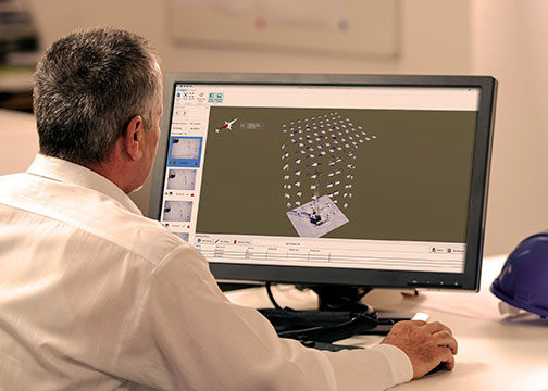
Topcon Positioning Group has introduced software to facilitate the data-processing workflow for UAV (unmanned aerial vehicle) infrastructure inspection.
MAGNET Inspect efficiently manages large UAV data sets to create inspection reports. It is designed to allow operators to easily visually navigate UAV photos, aligning 3D reality meshes with raw georeferenced images in one location and filtering them based on selected criteria including field of view.
“MAGNET Inspect will work with models from virtually any UAV,” said David Ahl, director of software product management. “When combined with Intel Falcon 8+ Drone – Topcon Edition and Topcon ContextCapture, powered by Bentley Systems, the software enables operators to efficiently navigate, annotate and create reports with inspection photos, effectively creating a very strong end-to-end inspection workflow.
MAGNET Inspect is now a key element of the Topcon end-to-end UAV and data processing workflow for inspection projects, Ahl said. It’s use aims to increase safety and speed data collection compared to traditional methods.
“The software allows operators to easily document the observations and report them. Images from the inspection can be flagged to indicate whether there are structural issues and annotated with built-in free-hand graphical tools. Data reports can then be created to include a preview image and link to high resolution annotated image,” Ahl said.
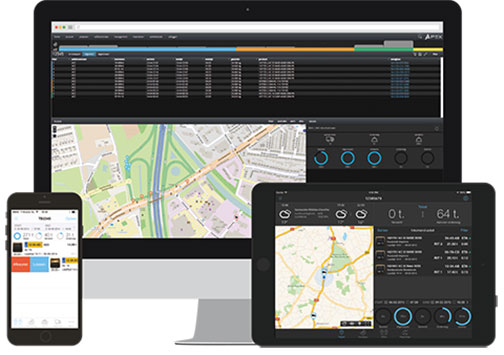
The ThunderBuild program. (Photo: Topcon/ThunderBuild)
Acquisition of ThunderBuild. In another announcement, Topcon announced the acquisition of ThunderBuild BV Group, expanding the portfolio of Topcon paving solutions. Based in Eindhoven, the Netherlands, ThunderBuild develops software related to logistics management with a primary focus in the asphalt market, as well as additional applications that pertain to the transport of bulk materials.
When I entered the civilian part of my GIS career as the GIS manager for the Atlanta Regional Commission, I tried to get first responders interested in GIS. Of course, in the early ’90s we were happy to be able to accurately draw points, lines and polygons on a piece of paper. Soon we had the luxury of ortho imagery as a backdrop for our GIS data, but I still couldn’t build a lot of enthusiasm among those first responders.
That changed completely when we started using metric oblique imagery provided by Pictometry. I realized that since we live in an oblique/3D world many non-GIS users had real difficulty visualizing objects or locations using two-dimension visualizations such as drawings, blueprints, maps or even ortho imagery.
By contrast, oblique views made visualization much easier for the vast majority of non-GIS users, and use of oblique imagery coupled with GIS tools exploded. Since then, many of us have been searching for faster, easier and cheaper ways to collect oblique imagery and video, and build 3D models.
For more than a decade, major defense contractors developed leading-edge systems to capture and exploit aerial imagery and video. Although effective, as one would expect of new custom technology, the systems were very expensive and out of reach for most local government agencies. Remote GeoSystems seems to have developed a system that leverages current technology to provide capabilities that may address some of those needs at a reasonable price.
Remote GeoSystems is in the business of capturing, displaying and managing “georeferenced” video and imagery. The company has designed and built high-end geospatial video recording systems for full motion video (FMV) and GIS mapping software primarily aimed at regulatory compliance of energy corridors, grids and critical infrastructure inspection applications.
Fortunately, my UAV is a DJI Inspire 1. I chose the Inspire because of its reputation, and because it seems to be the best combination of features needed for first-responder work at a prosumer price (about $3,500). The Inspire can record up to 4K video/12-mp stills, has a 94-degree field of view so there is no wide angle “fish-eye” distortion typical of an action camera, and has “Lightbridge” technology that permits positive control up to 3 miles and the ability to stream live 720p video (now 1080p) back to the ground controller.
The controller can feed large-screen video for command center group viewing via an HDMI output. Most important, the Inspire records GPS position data and altitude along with the video/imagery stream. (The DJI Phantom 3 Pro is a cheaper alternative that also records telemetry data, but if one upgrades to a 4K camera and the Lightbridge transmitter/receiver, the price approaches the integrated Inspire 1 price.)
An .srt file.
Since I’m always leery of marketing pieces and company demos, I wanted to try the system myself, and Remote Geo was happy to oblige. My first hands-on test was very satisfying. The LineVision software downloaded, unpacked and loaded quickly with no problems. I then recorded some aerial video of our condo building on Lake Guntersville near Huntsville, Alabama. I chose this building because it was convenient, safe to fly and a multi-story building in the open.
In addition to recording the video, one needs to turn on the DJI Inspire metadata recording to generate the .srt file. This is done in the DJI application “General Settings/Camera” by toggling “Video Caption” on. The .srt file was initially designed to provide altitude and location data as on-screen captions, but the data can be used as needed for other purposes.
When done with the flight and recording, transfer the video file and .srt file to your computer. Make sure the video file .mov/.mp4 and .srt file are in the same folder. Open LineVision and you will see an ArcGIS window. From the pull-down menu, load the video and you will instantly see the video play in a separate window with red position dots on the ArcMap view. As the video plays, the dot associated with the location of the UAV will turn yellow. If you click on any dot, the video will jump to that location/position on the video.
Here are screen captures of LineVision showing the ArcGIS view of an ortho image with red dots illustrating the path of the UAV:
One advantage of LineVision for first responders is that it is a complete package with ArcGIS embedded, all for a price well below $1,500. There is no need for a separate ArcMap license. Additionally, although LineVision Esri ArcGIS can display GIS data from online sources, if you have GIS data for your location loaded on your computer the system will operate in a disconnected remote environment. These sample screengrabs don’t do the system and video justice, since I recorded at 1080p rather than 4K. My laptop, this website and the reader’s playback equipment limit accurate playback of 4K content, so I did my work at 1080p.
I can envision a disaster-response scenario where the response team arrives on site, launches a UAV, and starts recording the scene. The captured video could then be loaded, viewed, indexed and cataloged with GIS data overlays on a laptop all in a matter of minutes, even in a disconnected environment. Hours, days or months later, finding the right video clip for analysis or forensics should be significantly easier and faster.
With the explosion of UAV hardware and software, it’s going to be an exciting year as new smaller, cheaper and more capable systems hit the market. Remote GeoSystems is working with UAV manufacturers to make LineVision capability available for many of the newcomers.
Leveraging UAV and LineVision capability, Skyline has worked with Remote GeoSystems to bring yet another capability: rapid 3D model creation. Taking appropriate geo-located frames of the video, Skyline uses its PhotoMesh software to build fully metric 3D models in short order. The full capability of this system and its 3D viewer TerraExplorer is so extensive that I will cover it in a future column, after this month’s ESRI Federal Users’ Conference. If you see me at the UC Feb. 24-25, please stop me and say hello.
Sentera LLC, a designer of sensors, software, and unmanned aerial vehicles (UAVs), has been granted a Section 333 exemption from the Federal Aviation Administration (FAA) to operate multiple types of commercially available UAVs. Applications for these systems include crop survey, infrastructure inspection, geospatial mapping and other aerial imaging missions.
“We are excited to receive the exemption,” said Sentera CEO, Eric Taipale. “While most exemption holders focus on providing revenue-generating flight services, Sentera flies primarily to demonstrate our products to customers and to gather and analyze aerial data which helps us enhance our OnTop Platform, a data management system designed specifically to support the thousands of images collected during a typical UAV flight.”
Sentera’s exemption for both fixed-wing and quadcopter UAVs ensures the company can capture a wide range of data types that are relevant to customer applications, including very high-resolution visual, multispectral, and thermal imagery, as well as specialized non-image information. Customers use Sentera input data to perform many tasks, such as developing planting and crop management advice for growers, building 3D models of buildings, structures, and terrain for asset owners, and monitoring environmental regulatory compliance for public agencies.
Comprehensive data management solutions are crucial to successful UAV inspections, asset audits, safety inspections, agriculture data collections, and point-cloud collection activities.
“Clients use a myriad of UAV-captured data types to increase safety, assess crop health, and boost ROI (return on investment),” explained Taipale. “Sentera already provides some of the most precise sensors and leading UAV solutions in the industry. Our Section 333 exemption allows us advance our OnTop Platform more rapidly, which ultimately helps our customers manage all of this data most efficiently.”
The FAA authorization allows Sentera to fly UAV platforms built by Lockheed Martin, DJI and Sentera.