Tag: Insitu

  • UAV Report: Growth trends & opportunities for 2019

    Special section, October 2018 GPS World.
    Special section, October 2018 GPS World. Cover photo: PrecisionHawk

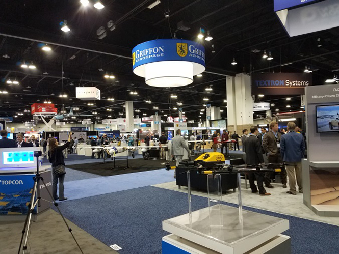
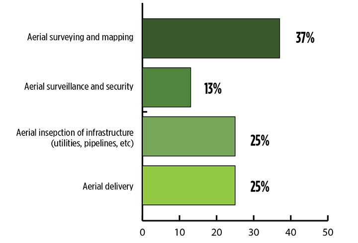
    If you blink, you might miss something! The examples here represent only a fraction of this booming field, but they show how diverse drone use has become. Interspersed among them, this article offers further insights on technology integration, the regulatory outlook and the economic future of this fast-moving industry.

    By Tony Murfin, Contributing Editor, UAV & Professional OEM

    Capturing where the drone industry has been this year and where it is headed in 2019 resembles trying to describe a Florida thunderstorm: how can there be so much rain so quickly, how long will it last, and what will the landscape look like afterwards? (I’m writing this during just such a deluge near Venice on the Gulf Coast.)

    The UAV/UAS industry has grown at such an amazing rate, it’s almost impossible to count or describe all the applications that have become normal practice, not to mention the number of companies involved in either making drone platforms or supplying drone integrators with sensors: GNSS, inertial, lidar, cameras photographic, thermal, infrared, video and more.

    From accident reporting to crop monitoring to infrastructure inspections, drones are, so to speak, on the rise. This year we have seen substantial increases in investments by equipment suppliers, continuing funding for military businesses, prototype systems for remotely identifying and even taking down drones, and vastly expanded use in mapping and survey.

    As precision guidance, autonomous operations, high-definition geocoded images and high-volume data processing all improve, drone usage will continue to increase. OEM receiver manufacturers, sensor suppliers and data-handling companies play key roles in development, and stand to profit thereby.

    The Delair Septentrio UX11 mapping UAV. (Image: Septentrio)
    The Delair Septentrio UX11 mapping UAV. (Image: Septentrio)

    In particular, use of drones is growing in land management, construction, mining and farming. An open-pit mine operation can be supported through detailed drone inspection producing high-resolution images. Processed images and data enable keeping tabs on inventory, site changes over time, identifying best areas for further extraction, and monitoring and managing vehicle movement. These tasks required huge amounts of time in the past. Drone overflight and processing tools condense all the effort as well as producing enhanced results to enable faster and clearer decision-making.

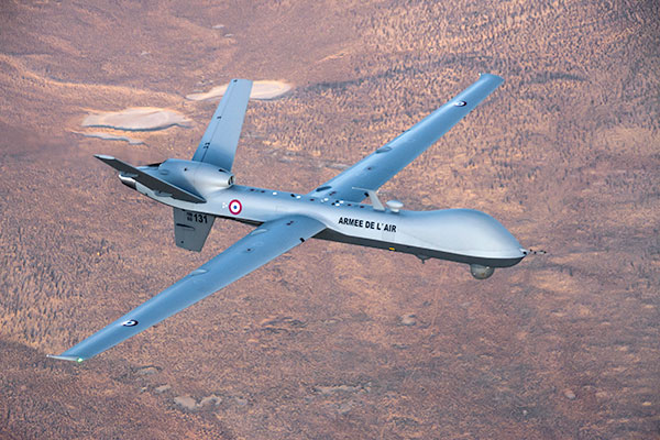
    Surveillance and reconnaissance are probably the biggest military drone applications. Carrying payloads that include color video cameras and infrared night vision cameras, more than 19,000 drones are now in the arsenal of the U.S. Army, Air Force, Marines and Special Ops, and more have gone to other nations’ militaries. Some fly at relatively low altitude, with limited range and powered by a single quiet electric motor; these drones have become essential in gathering forward-situation intelligence.

    The following examples represent only a small part of the industry. I selected them here to show how diverse drone use has become. Interspersed among them, I’ll offer further observations on technology integration, the regulatory outlook and the economic future of this fast-moving industry. If you blink, you might miss something!

    Accident Investigations

    In the past, when police arrived at a serious traffic accident, investigators had to use tape measures and roller wheels to construct an accurate physical record of the incident. More recently, police have used laser measuring tools but this still entails time-consuming procedures and produces traffic back-ups. Now police departments have started to collect highly accurate aerial images of traffic incidents using drones, and it’s proving quicker and more efficient.

    UAVs collect photos and videos, and software then stitches multiple high-resolution images together into a 2D or 3D map. With geolocation annotation provided by the drone, investigators can then take measurements directly from visual accident records.

    Previously, an investigation could take up to three hours gathering information manually, but with a drone overflying and documenting an accident this might be reduced to around 45 minutes. This clearly saves time and money for the police as well as drivers who suffer shorter traffic delays. With an investment of about $15,000 in drone hardware and training, payback can happen pretty quickly.

    Overall UAV Market Growth

    What is the killer app for drones? What professional UAV market sector will most powerfully drive adoption and influence new regulations for unmanned aerial vehicles? (Source: GPS World 2018 State of the GNSS Industry survey)
    What is the killer app for drones? What professional UAV market sector will most powerfully drive adoption and influence new regulations for unmanned aerial vehicles? (Source: GPS World 2018 State of the GNSS Industry survey)

    The drone logistics and transportation market was estimated to be valued at US $11.20 billion in 2022 and is projected to reach $29.06 billion by 2027, at a combined annual growth rate (CAGR) of 21.01%, according to India-based MarketsAndMarkets Research, in its May 2018 report.

    The logistics and transportation market was defined to include warehousing, shipping, infrastructure, software, military, freight, and even passenger and ambulance drones. “The increasing use of unmanned aerial vehicles in civil and commercial applications for faster delivery of goods is one of the most significant factors expected to drive the growth of the drone logistics market,” stated the report.

    The shipping segment is indeed projected to grow at the highest CAGR, as drones will see increasing use to transport a range of products from small packages to medical supplies and food. Venture capitalist investment in this market has been substantial as well as significant commitments by companies such as Amazon, Google, and Walmart in research and development to commercialize drone delivery services.

    Couple that with another report from the same company report on the drone analytics market, valued at $1.17 billion in 2016 and projected to reach $5.41 billion by 2022, at a CAGR of 28.11% from 2017 to 2022. The drone analytics market was considered to encompass agriculture and forestry, construction, insurance, mining, utilities, telecommunications, oil and gas, and scientific research.

    Both reports note that “The imposition of restrictions by various government agencies on the use of UAVs in civil and commercial applications is one of the major challenges faced by the drone logistics and transportation market.”

    In February of this year, MarketsandMarkets estimated that the overall UAV market was valued at $18.14 billion in 2017 and projected to reach $52.3 billion by 2025, at a CAGR of 14.15%.

    Agriculture

    Results of a survey of 269 farmers by Munich Reinsurance America indicate that three quarters of all farmers in the U.S.— from those with less than 100 acres to those with more than 5,000 — have either begun to use drones for precision agriculture, and monitoring crops, livestock and soil conditions, or are thinking about using drones. Roughly half of these farmers contract out the work to drone service suppliers and most use drones either daily or more than once a week.

    Sensor Integration

    What is the biggest challenge for the UAV industry? (Source: GPS World 2018 State of the GNSS Industry survey)
    What is the biggest challenge for the UAV industry? (Source: GPS World 2018 State of the GNSS Industry survey)

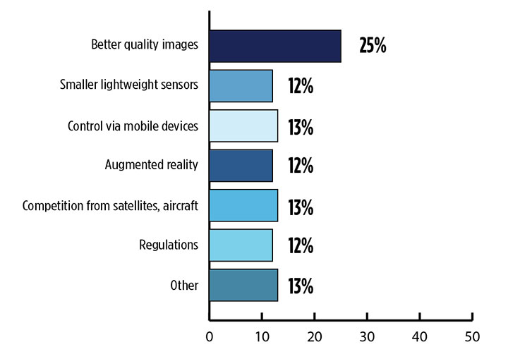
    As the size, weight and power (SWAP) and the accuracy of sensors continue to improve, drone use will continue increasing steadily. OEM receiver manufacturers, sensor suppliers and data-handling companies play key roles in this vital and ongoing development, and stand to profit thereby.

    Making it all work is a combination of sensor payloads gathering inertial and GNSS location, stills and video, lidar, thermal and hyperspectral data; the secret sauce lies in how the data is processed and presented to users. All these areas show significant growth. The following are only a few key examples.

    Lidar. Light detection and ranging (lidar) detects and measure the distance of an object or surface from an optical source, in this case a hovering or cruising UAV. GPS and inertial provide geo–referencing per each scan point.

    Lidar has seen increasing application in surveying and engineering, GIS mapping, accident scene reconstruction, topographic and coastline mapping, digital elevation model and digital surface model generation, mining and quarries, gas and oil pipelines, railroads and other infrastructure. As hardware costs decline, software begins to play more and more of a major role, becoming a larger part of the solution in every way.

    The M200 Snoopy series lidar package from LidarUSA is designed specifically for integration aboard the DJI M200 UAV. The laser scanning has a 100-meter maximum range, yielding 4-5 cm accuracy. It carries a tactical grade L1/L2 GPS/IMU unit and weighs 1.63 kg.

    Inertial Miniaturization. UAVs are driving even further size-downs of other navigation sensors as well.

    As just one example, the miniature μIMU from Inertial Sense incorporates a magnetometer, barometric pressure sensor, and L1 GPS (GNSS) receiver. Angular rate, linear acceleration, magnetic field, barometric altitude, and GPS location outputs are at 1 KHz with UTC time synchronization.

    ADS-B. Aerobits in Poland has developed a high-speed, miniaturized (23.0 x 18.0 x 2.5mm & weighing 2 grams) Automatic Dependent Surveillance-Broadcast (ADS-B) module which provides detect-and-avoid for small UAVs. The module accepts external GNSS position inputs and has high speed on-chip processing which enables processing of thousands of ADS-B signals/second from other aircraft/drones. Aerobits claims a reception range of over 200 miles due to a high-sensitivity RF front-end. With FAA-mandated equipage coming for aircraft in 2020, this potentially offers a detect-and-avoid option for even small drones.

    Regulatory Outlook

    The Association for Unmanned Vehicle Systems International has been an industry voice for more than 40 years. AUVSI president Brian Wynne recently told Congress what needs to be done to fully integrate UAS into the National Airspace System — a critical step in further drone development and growth.

    Initial regulations governing civil and commercial UAS operations are now in place. The FAA’s small UAS rule, known as Part 107, established a flexible, risk-based approach to regulating UAS and reduced many barriers to low-risk civil and commercial UAS operations. Since its enactment in 2016, however, demand for commercial UAS has exploded.

    “As of March 2018,” Wynne stated, “more than 150,000 platforms have been registered for commercial use. The FAA expects more than 450,000 UAS to be flying for commercial purposes over the next five years.” That’s three times as many as today!
    Waivers to Part 107 permit their holders to operate at night, as well as in certain restricted airspaces, beyond line of sight and over people. More than 1,700 operators across the U.S. have received these waivers.

    Continued adoption of unmanned flight will require an expanded regulatory framework that extends the waiver provisions much more widely. There are many challenges to this, particularly security concerns. A key step will be “implementing a remote ID system that identifies any UAS flying in the airspace, in real time.” according to Wynne.

    The FAA reauthorization bill recently passed by the House of Representatives calls for rulemaking concerning carriage of property, a necessary step for allowing UAS package deliveries — the next big thing.

    Military UAV Business Strong

    French MQ-9 Reaper. (Photo: DoD press release/UAS Vision)
    French MQ-9 Reaper. (Photo: DoD press release/UAS Vision)

    Military business remains a major source of revenue for the UAV/UAS industry, as demonstrated by the recent award of several contracts to various drone suppliers.

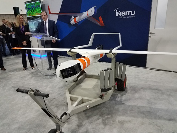
    U.S. Naval Air Systems Command recently awarded Insitu a ~$54 million fixed-price contract for four production RQ-21A Blackjack unmanned aircraft systems and eight attrition air vehicles: seven for the Marine Corps and one for the government of Poland.  The contract includes ground control stations, launch and recovery equipment, shipboard equipment kits as well as systems engineering and program management support.

    U.S. Army Contracting Command recently awarded General Atomics Aeronautical System Inc. (GA-ASI) a Grey Eagle engineering support contract worth ~$11m. Work will be undertaken at the GA-ASI facilities in Poway, CA and will run through to Sept 30, 2019.

    GA-ASI has also just won an FMS (Foreign Military Sales) contract worth $123 million for MQ-9 Reaper systems for France – deliveries are expected to be completed by May 2020. An FMS contract is normally how a foreign government procures U.S. government military equipment. The foreign government contracts with a U.S. agency, and the U.S. agency awards a back-to-back contract to the U.S. supplier. In this case, the U.S. contracting authority is the Air Force Life Cycle Management Center at Wright-Patterson Air Force Base.

    The U.S. Missile Defense Agency has awarded General Atomics Electromagnetic Systems (GA-EMS), San Diego, California, a contract worth up to ~$134 million to develop, integrate, and flight test an advanced sensor into the MQ-9 UAV. The work will be performed in San Diego, California from August 2018 through October 2021 with realistic flight testing scenarios taking place both within the U.S. and elsewhere.

    At the end of August, Boeing won the contest for the U.S. Navy’s unmanned refueling tanker with an $805 million contract award. The award covers the development and manufacturing of an initial four air vehicles. The future MQ-25 Stingray will be the first UAV to operate from U.S. aircraft carriers to refuel and extend the range of several combat aircraft.

    L3 Technologies has won a U.S. Army $454M contract to build, deliver and support an electro-optical infrared laser designator for the RQ-7Bv2 tactical UAS. The drone mounted payload will help the Army manage battlespace situational awareness, increase UAS survivability and obtain imagery for target/threat detection.

    Counter-UAS Systems

    DroneShield out of Australia markets a drone detection and mitigation system, known for its DroneGun, a point-and-shoot device able to disrupt multiple RF frequency bands simultaneously (433MHz, 915MHz, 2.4GHz & 5.8GHz), taking out the communication link to a drone operator — and also GNSS signals when so equipped — up to 1km away.

    The full DroneSentry detection system integrates a suite of sensors and countermeasures including radar, optical, RF listening, acoustic, thermal and an RF countermeasure transmitter with greater power/range than the portable DroneGun.

    Survey and Mapping

    SenseFly recently completed work on a three-year construction project in Northern Ireland to build the new A6 highway. A senseFly eBee Plus drone provided detailed aerial coverage and minimize interruptions with road traffic and ongoing quarry operations.

    Adopting an integrated aerial approach enabled the construction contractor to quickly obtain detailed, accurate, professional-grade data, and has helped save time and resources. Reducing the time required in the field and proximity to dangerous quarry sites optimized the mapping task

    High-Precision Survey Drone. The TRIUMPH-F1 UAV is built around the JAVAD GNSS TRIUMPH-1M receiver, the company’s high-precision geodetic GNSS receiver with 864 channels to track all current and future GNSS signals.
    When used on the ground, the TRIUMPH-F1 can function as a TRIUMPH-1M base or rover. The four motor arms (for eight motors) are detachable. Four screw inserts in the bottom to attach the TRIUMPH-F1 to a pole mount for field use.

    The TRIUMPH-F1 features user-friendly mission programming. The four lithium polymer batteries that power the eight propeller motors, arranged in a stacked quad formation.

    The TRIUMPH-F1 also has two micro-SD slots for image storage, a SIM card slot, a USB connector for uploading flight plans and downloading collected images, and indicators for satellite tracking and communications. Other indicators are dedicated to flight status and gyro.

    Vertical Landing. WingtraOne’s vertical landing technology enables touchdown in confined areas as small as 2 m x 2 m like boats or forest lanes. Combined with a flight range of up to 50 km, this makes large-coverage mapping missions feasible

    The vertical-take-off-and landing (VTOL) drone WingtraOne is designed to safeguard its valuable sensors and eliminate wear and tear of the equipment. Instead of broken wings or damaged cameras from belly landings and parachute touchdowns, the WingtraOne lands gently. During the vertical descent, laser sensor data enables the WingtraOne to sense the ground and land safely even on rocky or hilly hilly terrain.

    In case of a changing landing environment like a drifting boat or recently parked cars, the landing spot can be adjusted easily.

    The WingtraOne works truly autonomously during its entire mission, including take-off and landing. Instead of catapult or hand launches that can cause injuries or damage equipment, the WingtraOne takes off vertically without any human interaction.

    Shipping and Logistics

    Matternet, based in Switzerland, is testing deliveries using drones under a 3-year program run by the North Carolina Department of Transportation. The NC program is one of 10 authorized by the FAA to evaluate the commercial use of drones.

    The objective is to transport small items like blood samples, but initially vials of water will take the ride from a medical office building before landing on a hospital roof. In March, the company was authorized to operate drones over populated areas in Switzerland, carrying samples to hospitals in Lugano.

    Items can be securely deposited into the drone station for pick up or retrieved following delivery. A smartphone application is used to authorize pick up and delivery. The item is then scanned for pick up, the station automatically installs the item into the drone for transport, the drone then departs for the assigned destination and on arrival, scanning is required to retrieve the delivered item at the other end.

    Conclusion

    These examples just skim the surface of an exploding industry which just keeps on keeping on, constantly developing new solutions and applications. High-altitude pseudo satellite drones, drone delivery of goods within minutes of placing an internet order, automated drone facility inspections, power via wireless to keep drones airborne, parachute safety systems for drones….the list goes on and on.

    Clearly the UAV/UAS industry has only begun its journey. There are many unexpected places we can look forward to it visiting in coming months and years.

  • AUVSI Xponential: Major GNSS players exhibit new UAV products

    AUVSI Xponential: Major GNSS players exhibit new UAV products

    The Association for Unmanned Vehicle Systems International’s (AUVSI’s) Xponential 2018 show took place in Denver April 30-May 3. The event convenes the global community of commercial and defense leaders in intelligent robotics, drones and unmanned systems.

    AUVSI Xponential was a big show once again — 8,500 attendees, more than 600 exhibitors, 200 educational sessions and 400 speakers. The show floor was huge as usual, with virtually every kind of UAS product and service imaginable for inspection at small, large and larger booths or display areas.

    The morning kick-off presentation on Tuesday was enthusiastic about the coming large-scale adoption of drones and associated robotic technology, with a couple of real-time examples — driverless vehicles at Babcock Ranch in Florida and drone supply deliveries for humanitarian aid in Rwanda.

    A view of show floor.

    However, there still remain a number of barriers to wide-scale integration of drones into daily life from a regulation perspective, as Steven Bradbury, general counsel of the U.S. Department of Transportation, pointed out — while at the same time also indicating that the Federal Aviation Administration (FAA) has granted hundreds of waivers where the safety case has been adequate for lots of commercial UAS operations.

    Most of the major GNSS players were exhibiting at the show, so we focused on gathering their news while also collecting a flavor of the many drone system suppliers in attendance.

    U-blox introduced its new ZED-F9P multi-band, multi-constellation chip — with GPS, GLONASS, Galileo and BeiDou signal reception and processing and on-chip multi-band RTK with fast convergence times — promising centimeter-level accuracy and low 85 mA (4x GNSS) power consumption in a 17 mm x 22 mm package.

    ZED-F9P signals: coverage added in two stages. Option A – available now. Option B – available Q2/2020.

    Initial urban testing in Finland in challenging conditions has indicated RTK performance at 9 cm 94%, with high availability, short convergence times (<10 seconds) and fast reconvergence. This kind of performance is apparently initially targeted at automotive applications — u-blox is a member of the Sapcorda automotive group — and is forecasting samples for this July, with production beginning before the end of this year.

    The NovAtel tagline for the show was “Assured PNT,” which matches many U.S. and International agency objectives — this was accompanied by several announcements for both commercial and government agency products and applications.

    NovAtel’s new PwrPak7D.

    For UAV and other commercial applications, NovAtel has introduced several small-sized OEM7 based products, including the PwrPak7D (GNSS only) and PwrPak7DE1 (GNSS + Epson G320N MEMS IMU) — both dual-antenna heading capable, multi-frequency packages.

    The integrated E1 package includes NovAtel’s SPAN technology, which optimizes positioning and attitude performance during extended GNSS outages. Both new PwrPak enclosures come with the Interference Toolkit advanced interference detection and mitigation capability.

    With most UAVs, the electronics on the airframe can produce a disruptive internal interference environment, and can lead to potential problems for the integration of sensitive GNSS. To help overcome this issue, NovAtel has released the OEM7600 receiver board in an extremely small form factor, enclosed with protective shielding to reduce the effects of emissions from nearby electronics.

    The 7600 comes with 555 channels, multi-frequency/constellation positioning; L-band support for TerraStar corrections; serial, USB, CAN and Ethernet interfaces; advanced interference detection and mitigation features; RTK; GLIDE and Steadyline firmware options with 20-g vibration rating and the option to add integrated SPAN GNSS + inertial.

    NovAtel also announced Inertial Explorer Express, which provides the same core processing and utilities as Waypoint Inertial Explorer software for applications including unmanned aerial vehicles (UAVs) and smaller projects. Inertial Explorer Express will produce centimeter-level position and attitude solutions for lidar, camera and other sensor data with faster processing times and reduced complexity.

    On the government/agency business side of the house, NovAtel has been quite successful with the GAJT antenna, which includes integrated anti-jam technology. GAJT is in use operationally and has been shipped to 16 allied nations around the globe, with the latest success being with the artillery Observation Post Vehicles (OPV) for the Canadian Army.

    Canadian OPVs are used on the front-line of combat, so its essential that their location and timing information should not be compromised by enemy jammers. The NovAtel GAJT is readily retrofitted to existing vehicles to provide the necessary jamming defense needed by front-line forces.

    Previously, NovAtel also announced the selection of GAJT for the UK fleet of Type 26 Frigates – providing essential anti-jam protection for its onboard navigation system.

    MB-Two module by Trimble.

    Chris Wheeler and Omar Subra were good hosts when we visited them at the Trimble booth — Chris first made a YouTube video for GPS World (see below) and then gave me some insights into what’s new.

    Basically, the OEM line has rolled over new versions of almost all individual receiver boards, with the addition of the BeiDou B3 frequency, capability for RTX PPP (precise point positioning) corrections, the addition of new constellations and inertial integration options.

    An updated MB-Two receiver module can be configured for single frequency GPS through to dual frequency GPS, GLONASS, QZSS, Galileo and Beidou, uses RTX PPP and has an improved RTK engine for cm positioning from a base-station, or from over-the-air RTK corrections, or provides relative RTK against a moving base.

    A typical Trimble application could include capturing an Insitu ScanEagle UAV in a difficult shipboard multipath environment with integrated GNSS-inertial, UAV navigation and control, UAV payload stabilization, or providing a “truth-system” for autonomous unmanned ground vehicles.

    Since last year when Trimble introduced a “cell-phone” software receiver application, one useful application could have involved an insurance company using a “pocket-carried” antenna (with integrated RF) for field incident assessments. The cell-phone software license would be transferable to other assessors in the department, while a few pocket antennas are available for the whole assessment crew. This saves purchasing a whole load of hardware, and being limited to where the functionality can be moved or deployed. Everyone has a cell phone, and the relatively inexpensive antenna/RF can be available to all needing them.


    Watch this video to learn about Trimble’s latest products, including its BD990 and BD992 GNSS receiver boards.


    Trimble is also ramping up its OEM customer service and repair capabilities to improve turn around for multiple customers and applications in the field. Improved results are beginning to help customers and its OEM business, while increased R&D investment is expected to put new products into the field in the fall.

    This year Intel’s emphasis continued to be on how to manage the huge amount of data that high-precision visual and multi-spectral cameras are gathering by UAVs carrying out asset inspections for their customers. The Intel view is that this data is useless to an end-user unless it is interpreted and presented in a format that can be readily understood and used for the purpose it was intended.

    Let’s say a company operates 75 drones inspecting installations it owns or operates across several states, and that 50 GB of data is the nominal amount of data each drone collects on each mission. That means that nearly 4 TB of data could be collected daily if all 75 drones operate at once. More likely, over 1 TB daily shows up in a central location — a huge amount of unprocessed data.

    In a live demonstration, Intel showed how a typical installation inspection — by a drone taking high-resolution still photos at a remote location – could be collected and managed. Once in an Intel processing environment, the data quickly became visual format in 2D or 3D, and could be accessed remotely by an inspection team, saving significant travel costs and time to actionable results.

    Intel also promised to soon exceed its record at the Pyeongchang Winter Olympics for the number of drones flown at once — currently set at 1,218 drones. The company’s next target is for a light display using 1,500 multi-colored drones.

    Insitu CEO Esina Alic

    Insitu held a media event at the show to announce its ScanEagle-3 drone system. Esina Alic, the new Insitu CEO, led a team who introduced and then unveiled the new commercial-standard ScanEagle variant.

    This new variant has grown out of 20 years of experience and 15 years of working with the FAA to enable integration of drones into the U.S. National Airspace System (NAS). The ScanEagle-3 (SE-3) has been rebuilt with the objective of developing a certifiable vehicle with increased payload and endurance capability that is free of any ITAR restrictions — allowing export without restrictions to the rest of the world.

    Insitu unveils the ScanEagle-3 is at Xponential 2018.

    SE-3 features include:

    • Significantly increased (x2) payload
    • Still provides for full integration of all existing payloads
    • Commercial, non-ITAR product for the global market
    • Long-endurance platform
    • Service contracts available
    • Product release in Q2 2019
    • Fully compatible with existing launch and recovery systems
    • Around ~100 lb without payloads

    ScanEagle variants were used in emergency response to the California wildfires at Santa Rosa and Medicina, gathering real-time information for fire-line combatants.

    ScanEagle helped fight these wildfires using High Accuracy Photogrammetry (HAP) sensors. Military-grade electro-optical (EO) cameras during daylight and infrared (IR) cameras for night-time imaging extended the time available for tracking fire lines. Penetrating smoke or darkness, these UAVs gathered video and still images that were used to create geo-referenced, high-resolution digital fire progression and suppression maps to guide firefighting on the ground.

    ScanEagle helped firefighters battle blazes in California in September 2017. (Image: © Reuters)

    Summary

    This small overview of Xponential 2018 attempts to provide a flavor of the breadth of activity we saw at the show last week. A good portion of this has also been captured through short videos published on the GPS World website, along with news articles.

    There is more to come, with a report to follow from the show on Septentrio’s new product releases, Spirent’s GNSS simulation demo, DJI’s overview of drone products featured at the show, CyPhy Works tethered drones, Swift’s announcement of its Skylark correction service trials, Hemisphere’s new Vector Smart Heading Antenna, and Harxon’s antennas for drones.

    A big show to cover, that’s for sure! It’s a good sign that people were perhaps talking more business than in previous years and a sign that the UAS industry is perhaps moving into its next growth phase.

  • Insitu demos UAV/GIS system for fighting wildfires

    Following successful test flights, Insitu’s ScanEagle helps combat Oregon wildfire.

    UAV company Insitu and Esri have successfully completed test flights on a new way to support firefighting efforts using software for firefighters and first responders.

    The flights were held at the Warm Springs Federal Aviation Administration (FAA) Unmanned Aerial System (UAS) Test Range in Oregon. The test site is a Pan Pacific FAA UAS Test Site for commercial UAS testing. The national FAA test site program facilitates the UAS industry in meeting strict customer needs and qualifications.

    Insitu is a wholly-owned subsidiary of The Boeing Company.

    A week after successfully completing customer acceptance test flights, Insitu, which has more than one million operational UAS flight hours, deployed its INEXA Solutions professional aerial remote sensing teams to aid firefighters in suppressing the Eagle Creek fire in Oregon.

    Onlookers watch the fire burn in the Columbia Gorge on Sept. 4. (Photo: U.S. Forest Service)
    Onlookers watch the fire burn in the Columbia Gorge on Sept. 4. The fire is now contained. (Photo: U.S. Forest Service)

    Collaborating with customers to identify business challenges, INEXA Solutions professionals use a continually expanding suite of capabilities such as INEXA Control (ground-based command and control), INEXA Cloud, INEXA manned and unmanned air vehicles including ScanEagle, and INEXA sensors and analytics to provide custom solutions and answers to mitigate business challenges from seabed to space.

    Coordinating with the Oregon Department of Forestry and other governing entities, Insitu’s ScanEagle system provided optimal, near real-time data for firefighters and first responders, resulting in heightened emergency response efforts, increased situational awareness and safety, and supported planning and resource allocation.

    Equipped with electro-optical (EO) for daylight and infrared (IR) video for nighttime flights, along with mid-wave sensors, the ScanEagle surveyed fire lines at night over the Eagle Creek wildfire, which had spread to nearly 49,000 acres throughout the Columbia River Gorge region.

    The ScanEagle can supplement manned firefighting fleets by operating during dense smoke and at night, when manned aircraft typically cannot fly. Infrared camera technology can penetrate smoke and gather and disseminate georeferenced still images of points of interest. These images allow geographic information system (GIS) specialists to perform analysis using Esri’s ArcGIS software.

    “Throughout the difficult Eagle Creek wildfire, our thoughts have been with our friends and neighbors impacted by this unfortunate event,” said Mark Bauman, vice president and co-general manager, Insitu Commercial. “We stand prepared to assist local authorities with ongoing operations in any way we can, and we extend our gratitude to all of those working hard to contain the fire.”

    ScanEagle poised for launch at Eagle Creek, Oregon, fire.
    ScanEagle poised for launch at Eagle Creek, Oregon, fire.

    As the sole aviation overwatch within the temporary flight restriction, the ScanEagle provided persistent nighttime oversight and monitored the progression of the fire. Insitu coordinated manned and unmanned aviation assets and through data collection, analysis and integration capabilities, produced near real-time georeferenced spatial data (maps tied to specific known locations).

    In this way, incident commanders, firefighters, and first responders had data that delivered updated incident perimeter maps, identified spot fires, located fire lines and hotspots, and provided near real-time video feed and still images of critical infrastructure, historical structures and more.

    “Prior to pursuing any new effort, we consider the reasons we exist as a company — we call it our ‘why,’ explains Jon Damush, Insitu’s chief growth officer. “Insitu’s ‘why’ is to pioneer and innovate in all that we do to positively impact people’s lives and change the course of history,” he continues. “This statement guides our actions and investments, and is precisely why we are doing the things we are doing to help those in need with our unique technologies and professional approach to aviation.”

    (Based on an Insitu press release)

  • Insitu ScanEagle completes maritime search at Unmanned Warrior

    Insitu ScanEagle completes maritime search at Unmanned Warrior

    At the Royal Navy’s Unmanned Warrior demonstration, Insitu showcased its newest wide-area maritime surface search and identification technology for representatives from the Royal Navy as well as military and industry officials from across the globe.

    During the event, held in Benbecula, Scotland, the Insitu team was tasked to perform a range of maritime missions using ScanEagle equipped with the ViDAR payload. Developed in collaboration with Australia-based Sentient Vision Systems, ViDAR is a maritime surface search with automatic target finding capability on a group two unmanned platform.

    ScanEagle with ViDAR. (PRNewsFoto/Insitu)
    ScanEagle with ViDAR. (PRNewsFoto/Insitu)

    ScanEagle flew more than 55 hours, covering an area more than twice the size of Wales (41,500 km²) and using fewer than eight gallons of fuel.

    Despite sometimes challenging weather, ScanEagle with ViDAR autonomously detected hundreds of large and small objects in sea state six conditions. These included spotting and positively identifying two mine sweepers by number, spotting smaller objects such as stationary jet skis and buoys at 5 nm and locating 28 contacts from one sortie in fewer than two hours.

    ViDAR successfully and reliably detected objects through changing environmental conditions ranging from clear sun to wind, rain, haze and fog.

    ScanEagle flew more hours than any other participating platform.

    “During one flight our team spotted a target 19 nm away before the exercise began,” said Suzanne McNamara, vice president of business development for Insitu. “ScanEagle with ViDAR is a force multiplier that will establish a new standard for global navies. We are extremely proud of the successes we achieved during Unmanned Warrior and look forward to supporting our customers with this advanced capability.”

    In May, Sentient and Insitu confirmed the signing of an exclusive global distribution agreement for the ViDAR software for unmanned systems within the small UAS weight class. ScanEagle is the first and only unmanned platform to fly this payload.

  • Insitu awarded $71 million Blackjack UAS contract by NAVAIR

    Insitu awarded $71 million Blackjack UAS contract by NAVAIR

    Insitu has been awarded a US$71 million follow-on contract to produce six RQ-21A Blackjack unmanned aerial systems (UAS), with options for two more, from U.S. Navy Naval Air Systems Command (NAVAIR).

    The RQ-21A is recovered with the flight recovery apparatus cable aboard the San Antonio-class amphibious transport dock USS Mesa Verde after its first flight at sea. The tests were held in the Gulf of Mexico on Feb. 10, 2013.
    The RQ-21A is recovered with the flight recovery apparatus cable aboard the San Antonio-class amphibious transport dock USS Mesa Verde after its first flight at sea. The tests were held in the Gulf of Mexico on Feb. 10, 2013.

    The RQ-21A Blackjack has significantly larger payload mass, volume and power than other small UAS currently being used in theater, according to Insitu, a subsidiary of The Boeing Company. The system includes electro-optic and mid-wave infrared sensors with a laser rangefinder and infrared marker.

    The Low Rate Initial Production (LRIP) Lot V contract also includes an option year for nine Full Rate Production (FRP) systems. The FRP decision review is expected this fall.

    “This contract award paves the road for Blackjack’s continued and future fleet integration,” said Col. Eldon Metzger, program manager for the Navy and Marine Corps Small Tactical Unmanned Aircraft Systems Program Office. “It is at the tactical edge for Marine and Navy units and the foundation to support future system enhancements.”

    “Blackjack delivers an organic intelligence, surveillance and reconnaissance UAS that is runway-independent and founded on an open architecture that allows for implementation of innovative payloads to meet critical operational demands,” said Ryan M. Hartman, Insitu’s president and CEO. “We are proud to provide the sailors and marines with reliable, capable systems that support their warfighting needs.”

    NAVAIR awarded the STUAS Engineering Manufacturing Development contract to Insitu in 2010 to begin the development of RQ-21A Blackjack, a variant of the company’s Integrator unmanned system. The program achieved Milestone C in 2013, delivered the first LRIP system in 2014, and achieved initial operational capability in January.

  • Insitu and PrecisionHawk form commercial drone alliance

    Insitu and PrecisionHawk form commercial drone alliance

    Insitu and BNSF officials launch ScanEagle in support of the FAA's Pathfinder initiative. (Photo: Insitu)
    Insitu and BNSF officials launch ScanEagle in support of the FAA’s pathfinder initiative (Photo: Insitu)

    Insitu and PrecisionHawk have formed a strategic alliance to provide UAS solutions that help commercial enterprises achieve safe unmanned flight for extended and beyond-visual-line-of-sight operations. Insitu is a provider of information and unmanned aircraft systems (UAS) for commercial, civil and military operations, and PrecisionHawk is an aerial data provider.

    Both companies are exhibiting at this week’s AUVSI Xponential 2016 show in New Orleans.

    The alliance also leverages the extensive research and testing capabilities of two of the participants of the Federal Aviation Administration (FAA) Pathfinder Program, which is dedicated to expanding the use of UAS within the nation’s airspace.

    “While our businesses are diverse, the areas where we intersect have tremendous potential for creating new opportunities in the commercial industries we both serve,” said Ryan M. Hartman, Insitu President and CEO. “This alliance ensures that more businesses will explore what unmanned technology can offer.”

    Thanks to the integration of each company’s proprietary platforms, hardware and software, Insitu and PrecisionHawk plan to deliver even more data insights.

    “Our customers are always pushing us to bring more advanced and comprehensive solutions, and we go above and beyond to make sure we are developing tools that serve their specific needs,” said PrecisionHawk president Christopher Dean. “We believe this alliance with Insitu will help us deliver on our promise even more.”
    The emphasis of the U.S.-based alliance is on providing business intelligence support for commercial operations, including asset protection, property preservation, safety enhancement and environmental monitoring.

  • Insitu to focus on new commercial division at Xponential 2016

    Insitu is showcasing its new commercial business unit and platform of professional aviation products and services at the Association for Unmanned Vehicle Systems International’ Xponential 2016 May 3-5 in New Orleans.

    In booth 2213 in Hall 2, the company will highlight:

    • canEagle and RQ-21A Blackjack air vehicles.
    • Inexa | Control, a ITAR-free ground control station that gives operators professional aviation tools to safely operate unmanned systems while staying compliant with emerging Federal Aviation Administration (FAA) regulation.
    • FLARES, Insitu’s new Flying Launch and Recovery System that launches ScanEagle from the air and captures without ground equipment, expanding the environments where unmanned operations are possible to include jungles, courtyards and other small or restricted spaces.
    • The Insitu-Orbital Engine, an internal combustion propulsion system to be engineered from the ground up for small unmanned aerospace application. The engine is designed and tested to the FAA’s airworthiness standards for manned aircraft engines. In March, Insitu received a Commodity Jurisdiction from the U.S. Department of State placing its Multi-Fuel Direct Injection Engine under the export control purview of the U.S. Department of Commerce, Bureau of Industry and Security.
    • Microsoft HoloLens demonstrations. Microsoft’s high-definition hologram technology is integrated with Insitu’s Inexa | Control software to offer a new view of how decision makers and operators might manage unmanned systems in complex environments in the future.

    Insitu is a wholly owned subsidiary of The Boeing Company.

  • Insitu Blackjack UAS receives ‘go’ for Navy, Marine ops

    Insitu Blackjack UAS receives ‘go’ for Navy, Marine ops

    The Navy and Marine Corps’ RQ-21A Blackjack unmanned aircraft system (UAS) received the official green light for operation Jan. 13, marking a major milestone for the program.

    The program has achieved Initial Operational Capability (IOC), announced Marine Corps Deputy Commandant for Aviation Lt. Gen. Jon Davis. IOC confirms that the first Marine Unmanned Aerial Vehicle Squadron (VMU) squadron is sufficiently manned, trained and ready to deploy with the RQ-21A system.

    “We are ‘go for launch’,” said Col. Eldon Metzger, program manager for the Navy and Marine Corps Small Tactical Unmanned Aircraft Systems Program Office (PMA-263), whose team oversees the Blackjack program. “Achieving IOC designation means the fleet can now deploy using this critical piece of intelligence, surveillance, and reconnaissance architecture to enhance mission success.”

    Blackjack-insitu-O
    An RQ-21A Blackjack in flight during testing aboard USS Mesa Verde (LPD-19) in 2015. The Marines will deploy for the first time with the unmanned air system this summer. (U.S. Navy photo)

    In December 2015, builder Insitu delivered the first system from low-rate initial production (LRIP) lot 3 to VMU-2. The Blackjack system will support of the 22nd Marine Expeditionary Unit (MEU), based in Camp Legeune, North Carolina. The Marines will make their first shipboard deployment with the system this summer.

    “The Blackjack team has endured many long hours seeing this program to fruition and I am very proud to lead such a dedicated team of professionals,” Metzger said.

    A Blackjack system is comprised of five air vehicles, two ground control systems, and launch and recovery support equipment. At eight feet long and with a wingspan of 16 feet, the air vehicle’s open-architecture configuration is designed to seamlessly integrate sensor payloads, with an endurance of 10-12 hours.

    The expeditionary nature of the Blackjack, which does not require a runway for launch and recovery, makes it possible to deploy a multi-intelligence-capable UAS with minimal footprint from ships.

  • FAA Pathfinder test inspects rail tracks

    Launching at a tower site near Vaughn, New Mexico, Insitu accomplished a commercial beyond-visual-line-of-sight operation with an unmanned aerial system (UAS).

    The Oct. 25 event marked the beginning of a week-long series of flights with BNSF Railway designed to show how UAVs can enhance the safety of critical infrastructure by aiding with inspections.

    During the 14 hours of flyovers, the Insitu ScanEagle targeted problems such as washouts and bridge damage. The information gathered was then fed back to Insitu personnel on the ground in real time.

    Insitu and BNSF officials launch ScanEagle for the historic first flight. (Photo: Insitu Inc.)
    Insitu and BNSF officials launch ScanEagle for the historic first flight. (Photo: Insitu Inc.)

    The flights were part of the U.S. Federal Aviation Administration’s (FAA’s) Pathfinder program announced on May 6. For Pathfinder, the FAA selected three companies — CNN, PrecisionHawk and BNSF — to explore commercial use of drones beyond operations proposed in its draft UAS rule published in February.

    The FAA tasked BNSF Railway, the second-largest freight railroad network in North America, with inspecting rail infrastructure beyond visual line of sight. BNSF operates 32,500 miles of track.

    BNSF selected the Scan-Eagle because it carries an FAA certification for commercial applications. The UAV is capable of providing 3D rendering as well as high-resolution video magnification.

    In its first day of operations, the ScanEagle UAV provided real-time video covering 64 miles of the 132-mile stretch of track that BNSF has designated for the exercise. The ScanEagle is capable of flying for up to 24 hours at speeds of up to 80 knots.
    The exercise demonstrated how, in addition to a railway company’s traditional methods of track monitoring, unmanned aircraft can not only improve inspections, but keep employees out of harm’s way and harsh conditions.

    Insitu, a subsidiary of The Boeing Company, creates and supports unmanned systems and software technology for collecting, processing and understanding sensor data.

    Under Pathfinder, CNN is researching visual line of sight operations for newsgathering in urban areas, and working with Georgia Tech University to improve newsgathering for all organizations. PrecisionHawk is investigating agricultural operations for rural areas, flying outside line of sight.