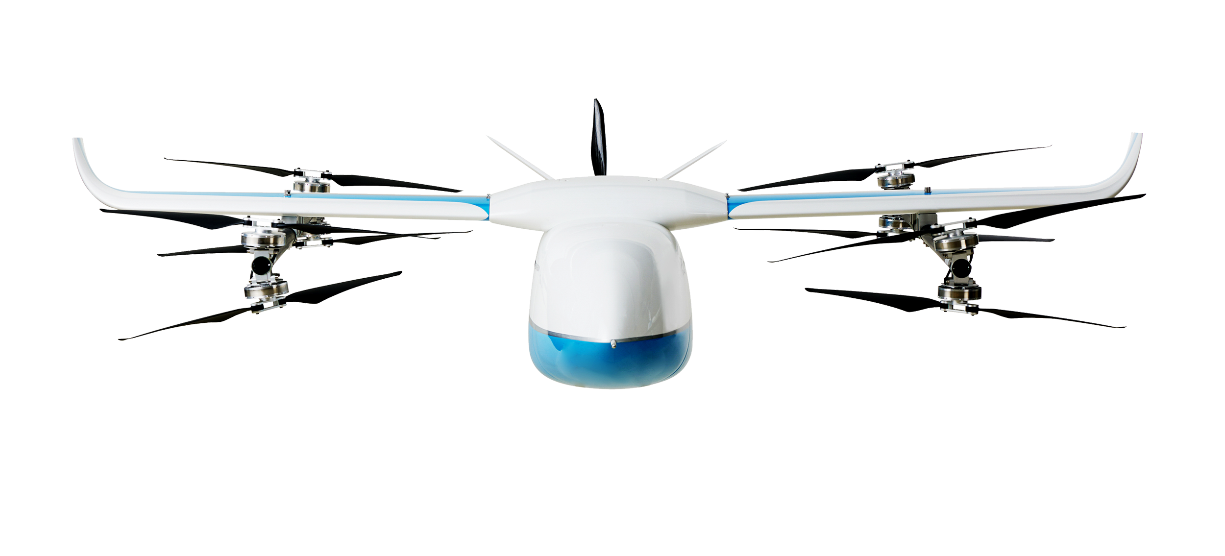
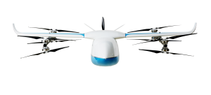
A2Z Drone Delivery, developer of commercial UAV delivery solutions, has released its delivery UAV, the RDSX Pelican. The Pelican leverages a hybrid vertical takeoff and landing (VTOL) airframe with no control surfaces to combine the reliability and flight stability of a multirotor platform, with the extended range of a fixed-wing craft.
With no ailerons, elevator, or rudder, the Pelican’s durable design eliminates common points of failure and extends operational time between maintenance overhauls. Designed to meet the 55 lb takeoff weight limitation for Federal Aviation Administration Part 107 compliance, the Pelican can carry payloads of 5 kg on missions up to 40 km, roundtrip.
The Pelican can be optimized for extended range operations or to deliver payloads from altitude with the company’s RDS2 UAV delivery winch.
Available in multiple configurations, the RDSX Pelican can be customized for an array of missions. The Pelican enables deliveries from altitude where spinning propellers are kept far from people and property, mitigating consumer privacy concerns of low-flying UAVs while abating intrusive rotor noise.
Alternatively, for missions in which the UAV can safely land at its destination, a simple servo-release mechanism can release payloads and expand the Pelican’s payload capacity.
Beyond logistics use cases such as residential deliveries, the Pelican is suitable for aerial mapping, UAV inspection, forestry services, search and rescue operations, water sample collection, offshore deliveries, mining, and more.
XTEND has acquired Performance Rotors, a Singapore-based UAV inspection company. This acquisition will improve XTEND’s ability to offer human-guided, remote interactive operations in a range of inspection scenarios.
“Performance Rotors’ mission has always been to develop UAVs and robotics solutions for data acquisition in GPS-denied and confined space environments, without the risk to human lives,” Keith Ng, co-founder and CEO of Performance Rotors, said. “We are confident that combining XTEND’s innovation XOS software with our world-class technology brings the best of the industry together in one powerful and easy to use solution that comprehensively addresses the critical challenges facing our customers today.”
XTEND provides human-guided autonomous machine systems that enable operators to perform accurate maneuvers and actions in any environment with minimal training. Its XOS operating system enables practical autonomy allowing professionals to control UAVs and smart machines that carry out complex tasks that require human interaction and decision-making safely and remotely.
Auterion, an open-source drone software platform provider, has partnered with C2 Group — a program, project and construction management firm — to power the use of drones for inspection, mapping and disaster response across the utilities and critical infrastructure industries.
The collaboration has been formed after C2 Group conducted extensive testing of the Vantage Robotics Vesper drone powered by Auterion to inspect power lines at its UAS testing ground and assess viability within the utilities space.
Auterion and C2 Group have seen a shift in the utility industry to move away from drones manufactured overseas to focus on the adoption of U.S.-made products such as the Vesper, a Blue sUAS-certified product used by the U.S. military.
Features on the Vesper that the utilities industry can use include high-quality sensors and thermal capabilities, while its stability and lightweight design make it rapidly deployable.
Utilizing the data security, quality and flexibility enabled by Auterion across multiple UAS manufacturers means C2 Group pilots can be trained on one flight platform but fly any drone associated with it; reducing the training time and increasing overall productivity. Further productivity measures are achieved with Auterion’s Suite used to identify pilot efficiencies and its Simulator to augment pilot training. At the same time C2, with its industry knowledge having worked with multiple major utilities in the US, is providing insight that is helping to shape Auterion’s roadmap for new sensors and airframes into the future.
Brandon Del Priore, CTO at C2 Group, said: “We are proud to partner with Auterion to bring some of the best technology developed in the US to our clients in the utilities and critical infrastructure industries. When safety, data security, and data quality matter most, C2 Group will be there to offer customers the same US-made hardware and software used by the DoD’s Defense Innovation Unit and the US military. The open source ecosystem is helping to drive a better footprint within the marketplace and a better level of compatibility for US made products.”
Cynthia Huang, VP Enterprise Business Development at Auterion, said: “With DJI added to the entity list, we’re seeing enterprise drone operators accelerate their search for alternatives. Auterion’s open source software ecosystem provides more options, more solutions, and faster development timelines to the needs being identified today and companies are embracing the power of our approach. We are excited to partner with C2 Group to bring US made solutions and the advantages of open source to their customers.”
For more information, visit www.auterion.com/enterprise
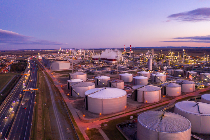
2,300-acre Shell Deer Park Refinery provides complex testbed for aerial inspections and incident response
Photo: SimonSkafar/E+/Getty Images
DJI is partnering with Shell Oil Company to create, test and deploy DJI drone technology at its Deer Park Manufacturing Complex to improve efficiency and worker safety during industrial inspections and emergency incident response.
The Shell Deer Park drone team adopted DJI drones in 2016 to reduce the need to work at height while improving safety and cutting the cost of inspections in the process. As a Solution Development Partner, Shell will work with DJI to develop and test advanced drone solutions, like the DJI Matrice 300 RTK, that allow workers to automate required inspections of critical infrastructure like flare tips and floating roof tanks whose condition and activity are difficult to assess from ground level.
“As one of the world’s largest energy companies, Shell has provided us with valuable insight into the unique challenges of conducting aerial inspections at one of its largest facilities where infrastructure exceeds the height of 250 feet off the ground,” said Cynthia Huang, until recently the director of business development at DJI. “Through our collaboration, DJI will receive valuable first-hand insight into the complexities of deploying drone technology at a world-class refinery, and co-develop new product features like AI Spot-Check that will allow Shell and other innovative energy companies to use drones to safely and easily conduct required inspections of critical infrastructure.”
“Shell Deer Park is excited to become a Solution Development Partner with DJI as we continue to adopt drone technology,” said Shell Deer Park’s Chief Drone Pilot John McClain. “Through this partnership, Shell Deer Park will have access to some of the most advanced drone technology from DJI to help elevate workplace safety and improve efficiency across our operations in the world’s largest industry.”
Phase One Industrial has expanded its RS and RSM lens offering with three new high performance lenses for high-altitude aerial photography and long-range aerial and ground inspection applications.
The 300mm AF, 180mm, and 150mm MK II lenses are designed to enhance the performance and flexibility of Phase One Industrial’s iXM-RS and iXM aerial camera series. Each offers precision imagery, taking advantage of the cameras’ ultra-high resolution backside-illuminated (BSI) CMOS sensors, to maintain a smaller ground sample distance (GSD) while flying at higher altitudes, the company said.
Phase One RSM 300mmAF. With the longest focal length in the line-up, this lens offers a 5 cm GSD from 13,000 feet. It fits both iXM and iXM-RS camera models and produces superb image quality by enhancing the cameras’ ultra-high resolution BSI CMOS sensors (3.76 µm pixels).
The lens is designed for both high-altitude 2D and 3D mapping and long-range ground inspection. The motorized lens offers a focus range of 10 m to infinity within which a predefined distance can be set remotely. A self-locking mechanism is built in to secure the focus position against vibrations.
5 cm GSD from 13,000 feet
10 m to infinity focusing range
f/8 – f/32 aperture range
1/2000 sec exposure time
RS Shutter reliability – 500,000 actuations
Rodenstock RS 180mm. Specified by Phase One and built by Rodenstock Photo Optics, Germany, this lens reaches a 5 cm GSD from 8,000 feet when used with the iXM-RS150F camera. The lens supports the camera’s ultra-high resolution BSI sensor for greater image quality and is integrated with a Phase One RS reliance shutter for speed and reliability. The RS 180mm enhances high-altitude aerial 2D and 3D mapping and improves efficiency in oblique configurations.
5 cm GSD from 8,000 feet
f/6.3 – f/22 aperture range
1/2000 sec exposure time
RS Shutter reliability – 500,000 actuations
Phase One RS 150mm MK II. A 5 cm GSD from 6,500 feet is achievable with the RS 150mm MK II lens. It complements the iXM-RS150F camera’s ultra-high 150-megapixel resolution BSI CMOS sensor for acquiring quality images for high-altitude aerial 2D and 3D mapping.
5 cm GSD from 6,500 feet
f/5.6 – f/22 aperture range
1/2500 sec exposure time
RS Shutter reliability – 500,000 actuations
Every Phase One Industrial lens is rigidly built for robustness against vibrations and shocks to meet RTCA DO160G standards, and is individually tested for performance and high-modulation across the whole image area.
Drone company PrecisionHawk has announced a partnership with EagleView, a provider of aerial imagery and data analytics for government, insurance and commercial sectors.
PrecisionHawk also announced that it has purchased both HAZON Inc. and InspecTools Inc., businesses that specialize in the delivery of inspection services and technology for the energy industry.
Both companies bring demonstrated expertise to enable tighter integration between the collection and the analysis of drone data, PrecisionHawk said. Paul Bingaman, CEO of InspecTools, and David Culler, CEO of HAZON, will join PrecisionHawk’s executive leadership team.
EagleView partnership for insurance claims
EagleView’s partnership with PrecisionHawk enables drone insurance inspections. (Photo: PrecisionHawk)
Through the partnership with PrecisionHawk, EagleView will collect at-scale insurance claims imagery via drones by leveraging PrecisionHawk’s global network of drone pilots, Droners.io.
The addition of PrecisionHawk’s drone pilot network will benefit EagleView OnSite Solutions for remote claims inspection. EagleView OnSite virtual desk adjustment combines imagery from multiple sources, including drones, with a variety of data analytics and reports to enable adjusters to efficiently triage claims, virtually inspect properties from their desk, and ultimately close property and casualty (P&C) claims faster.
“EagleView OnSite provides insurance customers with all the tools necessary to settle claims without ever going into the field,” said Rishi Daga, CEO of EagleView. “As drones transform the way the insurance industry operates, making inspections safer, easier and more cost effective, EagleView reinforces its commitment to drone technology to digitize manual workflows.”
Virtual drone inspections for insurance claims address a challenging trend in the P&C insurance industry. Over the past 20 years, the number of experienced insurance adjusters has dropped dramatically, causing labor shortages — especially after major storms hit. The demand for insurance adjusters is high, yet drone pilots add a new, untapped “labor force” to the equation.
Combining the EagleView OnSite virtual desk adjustment solution with PrecisionHawk will offer the insurance industry thousands of certified, trained drone pilots to perform high-quality insurance inspections at a competitive cost. With more than 25,000 claims processed by EagleView OnSite in the last 18 months, EagleView can help insurance carriers transform their property claim workflows and decrease cycle time by at least 40 percent to best serve their customers after a catastrophic natural disaster.
Drone technology and analytics for the energy market
HAZON brings extensive aviation experience, standards-based operating procedures, certified drone flight operations and inspection services, widely regarded as the best in the energy industry, to the PrecisionHawk team. The company has delivered more than 13,000 inspections totaling over 8,000 hours of flight time, with a majority focused in energy markets for Fortune 500 utilities.
InspecTools brings high-fidelity machine vision software and data analysis tools built for the renewable energy market. Their market-leading software for both solar-panel and wind-turbine inspection is utilized by some of the largest equipment manufacturers and service providers in the world. Customers like Vestas, PG&E and SMA Solar rely on InspecTools’ sophisticated reporting, analytics and machine learning capabilities.
“We’re very pleased to bring together the established technology and multi-market reputation of HAZON and InspecTools with PrecisionHawk’s experience, team and expanded portfolio,” said Michael Chasen, CEO of PrecisionHawk. “By combining these offerings, our customers will have access to extensive and leading-edge energy products and services, regulatory expertise and a record of safe, secure and compliant operations.”
Thanks to advances in technology and regulations, the energy market has quickly moved from experimenting with pilot projects to large scale deployment of drone solutions, PrecisionHawk said. Across distribution lines, transmission lines, solar panels, wind turbines, oil and gas and utility infrastructure, and emergency response, energy presents a current global market opportunity of $9.7 billion.
According to IDC, worldwide spending on robotics and drones will accelerate over the next four years reaching $201.3 billion in 2022. While the value is clear across time, safety improvements and operational efficiency, scaling and managing a drone program can be complex.
“HAZON is excited to bring our world-class best practices and reputation for standards-based operations and safety to the PrecisionHawk team,” said Culler. “By joining PrecisionHawk, our customers gain access to the next level of technological sophistication for more scalable, predictive and cost-efficient drone solutions that drive better business intelligence.”
“InspecTools brings years of experience, analytics tools and machine vision software for renewable energy that is an immediate value-add to PrecisionHawk’s software analytics platform,” Bingaman said. “This relationship further enhances the technologies and services that are fundamental to advancing the economic potential of drones in the energy market.”
The acquisition of HAZON and InspecTools underscores PrecisionHawk’s strategy to operate in high-growth markets and accelerate the adoption of commercial drones.
The acquisitions, which are subject to customary closing conditions, are expected to close later this month.
Sharper Shape, a provider of unmanned aerial utility inspection solutions, has released the Heliscope 2.0, an onboard payload system that expands the company’s aerial sensing portfolio into the manned helicopter industry.
According to the company, the Heliscope 2.0 integrates multiple sensor systems into a single, lightweight helicopter payload, capable of simultaneously collecting a range of data types required for utility maintenance and vegetation management inspections.
Deployment of the Heliscope 2.0 enables optimized inspection and maintenance schedules, offering potential cost savings in those operational activities by as much as 50 percent.
The Heliscope 2.0 also stands out with its flexible mounting configurations and ability to adapt for mounting on many different helicopter types.
For example, the system can be mounted on most Bell Jet/Long Ranger helicopters using its FAA-approved nose mount, or attached to numerous other typical helicopter models using its unique Glider aerodynamic sled.
The U.S. Federal Aviation Administration (FAA) permits mounting the Heliscope 2.0 to helicopters by using the cargo hook found on many helicopter models; this user-friendly method is approved by FAA under a classification for gliders.
“While drones are a very flexible and safe method for performing utility inspections, there are situations where manned helicopters are the preferred vehicle to host sensors during certain utility inspections,” said Mikko Saarisalo, Sharper Shape’s vice president of drones and project lead for the Heliscope 2.0 project. “The new Heliscope 2.0 provides a solution for those situations where we need to operate over greater distances or in harsher environments than the drones can easily accommodate. This system takes our data harvesting efficiency and productivity up to a level unprecedented in the industry.”
CORE includes algorithms to automatically analyze lidar point clouds and quickly generate utility vegetation management reports. Further, its unique automatic issue detection (AID) machine vision software uses artificial intelligence (AI) to eliminate the daunting task of performing frame-by-frame image data inspection, allowing personnel to focus on other aspects of inspection compliance.
CORE applications work equally well with either Sharper Shape’s proven unmanned aerial inspection services, or with the new Heliscope 2.0 manned aircraft solution.
“The fact that the Heliscope 2.0 integrates fully with our CORE software suite is a huge benefit,” said Sharper Shape CEO Ilkka Hiidenheimo. “We can collect all the key inspection assets and measurements in one high-speed pass, and then easily pass these files to our CORE suite for automatic processing. Sharper Shape is the only company on the market that offers this range of options for collecting aerial data and for processing this data automatically into a wide range of digital report formats.”
The Heliscope 2.0 system is now available for immediate contract services in the U.S., South America and Europe.
Pergam gas sensor aboard the Microdrones md4-1000 UAV.
The professional aerial methane detector mdTector1000 CH4 from Microdrones makes it easy to detect methane gas via a fully integrated aerial package for professionals responsible for methane gas infrastructure.
The mdTector1000 CH4 has a Pergam gas sensor, mounted and integrated with the Microdrones md4-1000 UAV. In real time, users can see aerial shots of detection with the laser sensor, the company said. The carbon-fiber built UAV goes into dangerous areas unsuitable for workers.
The mdTector1000 CH4 can be used for natural gas line surveys, tank inspections, gas well testing, plant safety and landfill emission monitoring.
The mdCockpit Android App allows users to maintain visualization in flight. A special mdTector app allows users to visualize and present all post-flight data on one map.
Drones could soon be inspecting powerlines in India, thanks to a partnership between Sharper Shape and Sterlite Power.
Sharper Shape, based in Palo-Alto, California, offers automated drone-based asset inspections. Sterlite Power is a power transmission company in India.
The Sharper Shape Sharper A6 drone is designed for beyond-visual-line-of-sight (BVLOS) flights.
Sharper Shape has already spearheaded the adoption of long-distance commercial drone flights for utilities in Europe. In the U.S., Sharper Shape is part of the EEI Sharper Utility partnership, an industry collaboration aimed at demonstrating and developing commercial long-distance drone flights for electric companies.
As part of the cooperation, Sterlite Power will make a minority investment in Sharper Shape to foster Indian market growth and continued technology development. The companies signed a partnership agreement during Make in India Week in Mumbai in February, an event held to spur innovation, design and sustainability.
Sterlite Power and Sharper Shape are awaiting approvals from India’s Directorate General of Civil Aviation for large-scale, long-distance inspection flights. Long-distance drone flights could provide significant benefits with safe, efficient and fast inspections compared to manned helicopter flights.
Utilities in India. The partnership also intends to provide services for other utilities in India. India has a power transmission network of more than a million circuit kilometers, which undergoes double-digit growth annually. The use of drones will increase the uptime of the grid, reduce transmission tariffs, avoid grid blackouts, and save the environment by reducing deforestation along the line corridors.
Sterlite Power has already introduced lidar for surveys and helicopters to avoid disturbances to farm activities and speed the process to commission much-needed infrastructure in India. Soon, it will deploy heli-cranes to erect transmission towers in the challenging terrains of Jammu and Kashmir.
In the United States…
In August, Sharper Shapesubmitted a waiver application to the U.S. Federal Aviation Administration (FAA), requesting approval to perform beyond-visual-line-of-sight (BVLOS) flights. The waiver would allow members of the Edison Electric Institute (EEI)-Sharper Shape partnership to demonstrate and develop commercial long-distance flights for electric company asset inspections.
BVLOS flights are able to travel 10–20 miles, compared to roughly one-third of a mile under visual-line-of-sight regulations.
The test flights will leverage Sharper Shape’s new Sharper A6 drone and Sharperscope 5.0 payload. The A6 is optimized for BVLOS asset inspections, using four redundant cellular networks to make it virtually impossible for the drone to lose communication with ground-control operators, the company said.
Sharper Shape leverages the LTE commercial multi-billion-dollar networks, while other vendors use point-to-point, which can’t communicate beyond line of sight, or satellite connection, which suffers from high costs and invariable latency that increases the response time and impedes a pilot’s ability to make quick adjustments during flight.