Congatec is offering a workload consolidation kit for vision-based situational awareness applications such as machine control and vision-based collaborative robotics.
The kit qualifies as an Intel internet of things (IoT) ready-for-production kit. It offers three virtual machines based on the hypervisor technology from Real-Time Systems.
One runs a vision-based artificial intelligence application based on the Intel OpenVino situational awareness software. The second is real-time capable and operates deterministic control software, and the third acts as an industrial IoT/Industry 4.0 gateway.
The U.S. Department of Transportation’s Federal Aviation Administration (FAA) announced the eight companies that will assist the federal government in establishing requirements for future suppliers of Remote Identification (Remote ID).
Remote ID will enable unmanned aircraft systems (UAS), commonly called drones, to provide identification and location information while operating in the nation’s airspace.
The FAA selected the following companies to develop technology requirements for future Remote ID UAS Service Suppliers (USS):
“The FAA will be able to advance the safe integration of drones into our nation’s airspace from these technology companies’ knowledge and expertise on remote identification,” said U.S. Transportation Secretary Elaine L. Chao.
This initial group will support the FAA in developing technology requirements for other companies to develop applications needed for Remote ID. The applications will provide drone identification and location information to safety and security authorities while in flight.
The technology is being developed simultaneously with the proposed Remote ID rule. Application requirements will be announced when the final rule is published. The FAA will then begin accepting applications for entities to become Remote ID suppliers. The FAA will provide updates when other entities can apply to become qualified Remote ID USS on FAA.gov.
Drones are a fast-growing segment of the transportation sector with nearly 1.5 million drones and 160,000 remote pilots now registered with the FAA. The agency’s ability to develop Remote ID technology simultaneously with the rule enables the FAA to continue to build on a UAS Traffic Management (UTM) system that has demonstrated global leadership through the small UAS rule and the implementation of the Low Altitude Authorization and Notification Capability (LAANC), which automates the application and approval process for most UAS operators to obtain airspace authorizations.
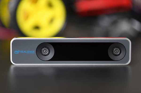
The RealSense camera uses two fisheye lenses and an IMU to construct location awareness. (Photo: Intel)
The Intel RealSense Tracking Camera T265, designed for positioning and maneuvering mobile robots and other portable systems, includes an inertial measurement unit (IMU) that enables developers to create solutions with advanced depth-sensing and tracking capabilities. Intel introduced the camera in Q1 of 2019. An earlier model, the D435i, also includes an IMU but is a depth camera, not a tracking camera.
As robots, drones and other autonomous mobile devices must — eventually — interact independently and intelligently with their environments, they must track their locations as they move, navigating unfamiliar spaces while discovering, monitoring and avoiding still and moving obstacles in real time.
Block diagram of camera components. (Image: Intel)
Moving toward that goal, the T265 includes two fisheye lens sensors, an IMU and an Intel Movidius Myriad 2 video processing unit (VPU), a system-on-chip component for image processing and computer vision at very high performance per watt.
Vision-based simultaneous localization and mapping (V‑SLAM) algorithms run directly on the VPU with very low latency. The T265 has demonstrated less than 1% closed-loop drift under intended use conditions. It also offers sub 6 ms latency between movement and reflection of movement in the pose.
The RealSense device measures 1 x 0.5 x 4 inches (108 mm x 24.5 mm x 12.5 mm), weighs around two ounces (55 g), and draws 1.5 watts to operate the entire system, including the cameras, IMU and VPU. Its spatial sensing and tracking capabilities are based on technology developed by RealityCap, acquired by Intel in 2015.
The camera performs inside-out tracking: it does not depend on external sensors to understand its environment. Tracking is based on information gathered from the two fisheye cameras, each with a 163-degree range of view (±5 degrees) and capturing images at 30 frames per second. The wide field of view from each sensor keeps points of reference visible to the system for a relatively long time, even if moving quickly.
Visual-Inertial Odometry. A key strength of visual-inertial odometry is that the sensors complement each other. The images from the camera are supplemented by data from the onboard IMU, which includes a gyroscope and accelerometer. The aggregated data from these sensors is fed into the SLAM algorithms.
The algorithm identifies sets of salient features in the environment, such as a corner of a room or object that can be recognized over time to infer the device’s changing position relative to those points.
The visual information prevents long-term drift from the inertial that degrades position accuracy. The IMU operates at a higher frequency than the cameras, allowing for quicker response and recognition by the algorithm to changes in the device’s position. A map of visual features and their positions is built up over time. In re-localization, the camera uses the features it has seen before to recognize when it has returned to a familiar place. The camera can locate its point of origin with an error margin of less than one percent.
Drone testing demonstrated that, in both cases, the tracking and position data generated by the peripheral was closely correlated with what was provided by GPS. This supports the viability of using it for navigation in areas where GPS is not available, such as under a bridge or inside an industrial structure.
Topcon Positioning Group’s Dave Henderson explains how Topcon’s products are integrated in Intel’s Sirius Pro fixed-wing UAV and Falcon 8+ drone at Xponential 2018 in Denver. Henderson also gives an overview of the new Topcon payloads that will be available for the Falcon 8+.
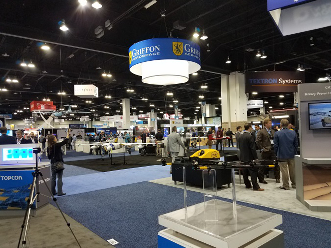
AUVSI Xponential was a big show once again — 8,500 attendees, more than 600 exhibitors, 200 educational sessions and 400 speakers. The show floor was huge as usual, with virtually every kind of UAS product and service imaginable for inspection at small, large and larger booths or display areas.
The morning kick-off presentation on Tuesday was enthusiastic about the coming large-scale adoption of drones and associated robotic technology, with a couple of real-time examples — driverless vehicles at Babcock Ranch in Florida and drone supply deliveries for humanitarian aid in Rwanda.
A view of show floor.
However, there still remain a number of barriers to wide-scale integration of drones into daily life from a regulation perspective, as Steven Bradbury, general counsel of the U.S. Department of Transportation, pointed out — while at the same time also indicating that the Federal Aviation Administration (FAA) has granted hundreds of waivers where the safety case has been adequate for lots of commercial UAS operations.
Most of the major GNSS players were exhibiting at the show, so we focused on gathering their news while also collecting a flavor of the many drone system suppliers in attendance.
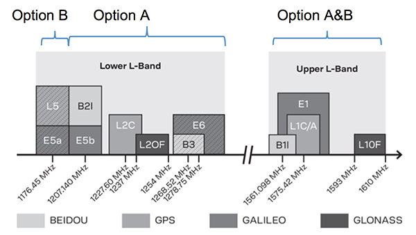
U-blox introduced its new ZED-F9P multi-band, multi-constellation chip — with GPS, GLONASS, Galileo and BeiDou signal reception and processing and on-chip multi-band RTK with fast convergence times — promising centimeter-level accuracy and low 85 mA (4x GNSS) power consumption in a 17 mm x 22 mm package.
ZED-F9P signals: coverage added in two stages. Option A – available now. Option B – available Q2/2020.
Initial urban testing in Finland in challenging conditions has indicated RTK performance at 9 cm 94%, with high availability, short convergence times (<10 seconds) and fast reconvergence. This kind of performance is apparently initially targeted at automotive applications — u-blox is a member of the Sapcorda automotive group — and is forecasting samples for this July, with production beginning before the end of this year.
The NovAtel tagline for the show was “Assured PNT,” which matches many U.S. and International agency objectives — this was accompanied by several announcements for both commercial and government agency products and applications.
The integrated E1 package includes NovAtel’s SPAN technology, which optimizes positioning and attitude performance during extended GNSS outages. Both new PwrPak enclosures come with the Interference Toolkit advanced interference detection and mitigation capability.
With most UAVs, the electronics on the airframe can produce a disruptive internal interference environment, and can lead to potential problems for the integration of sensitive GNSS. To help overcome this issue, NovAtel has released the OEM7600 receiver board in an extremely small form factor, enclosed with protective shielding to reduce the effects of emissions from nearby electronics.
The 7600 comes with 555 channels, multi-frequency/constellation positioning; L-band support for TerraStar corrections; serial, USB, CAN and Ethernet interfaces; advanced interference detection and mitigation features; RTK; GLIDE and Steadyline firmware options with 20-g vibration rating and the option to add integrated SPAN GNSS + inertial.
NovAtel also announced Inertial Explorer Express, which provides the same core processing and utilities as Waypoint Inertial Explorer software for applications including unmanned aerial vehicles (UAVs) and smaller projects. Inertial Explorer Express will produce centimeter-level position and attitude solutions for lidar, camera and other sensor data with faster processing times and reduced complexity.
On the government/agency business side of the house, NovAtel has been quite successful with the GAJT antenna, which includes integrated anti-jam technology. GAJT is in use operationally and has been shipped to 16 allied nations around the globe, with the latest success being with the artillery Observation Post Vehicles (OPV) for the Canadian Army.
The NovAtel GAJT-710ML GPS anti-jam antenna.
The Type 26 Frigate of the British Fleet will use NovAtel anti-jam technology. (Photo: BAE Systems)
Canadian OPVs are used on the front-line of combat, so its essential that their location and timing information should not be compromised by enemy jammers. The NovAtel GAJT is readily retrofitted to existing vehicles to provide the necessary jamming defense needed by front-line forces.
Previously, NovAtel also announced the selection of GAJT for the UK fleet of Type 26 Frigates – providing essential anti-jam protection for its onboard navigation system.
MB-Two module by Trimble.
Chris Wheeler and Omar Subra were good hosts when we visited them at the Trimble booth — Chris first made a YouTube video for GPS World (see below) and then gave me some insights into what’s new.
Basically, the OEM line has rolled over new versions of almost all individual receiver boards, with the addition of the BeiDou B3 frequency, capability for RTX PPP (precise point positioning) corrections, the addition of new constellations and inertial integration options.
An updated MB-Two receiver module can be configured for single frequency GPS through to dual frequency GPS, GLONASS, QZSS, Galileo and Beidou, uses RTX PPP and has an improved RTK engine for cm positioning from a base-station, or from over-the-air RTK corrections, or provides relative RTK against a moving base.
A typical Trimble application could include capturing an Insitu ScanEagle UAV in a difficult shipboard multipath environment with integrated GNSS-inertial, UAV navigation and control, UAV payload stabilization, or providing a “truth-system” for autonomous unmanned ground vehicles.
Since last year when Trimble introduced a “cell-phone” software receiver application, one useful application could have involved an insurance company using a “pocket-carried” antenna (with integrated RF) for field incident assessments. The cell-phone software license would be transferable to other assessors in the department, while a few pocket antennas are available for the whole assessment crew. This saves purchasing a whole load of hardware, and being limited to where the functionality can be moved or deployed. Everyone has a cell phone, and the relatively inexpensive antenna/RF can be available to all needing them.
Watch this video to learn about Trimble’s latest products, including its BD990 and BD992 GNSS receiver boards.
Trimble is also ramping up its OEM customer service and repair capabilities to improve turn around for multiple customers and applications in the field. Improved results are beginning to help customers and its OEM business, while increased R&D investment is expected to put new products into the field in the fall.
This year Intel’s emphasis continued to be on how to manage the huge amount of data that high-precision visual and multi-spectral cameras are gathering by UAVs carrying out asset inspections for their customers. The Intel view is that this data is useless to an end-user unless it is interpreted and presented in a format that can be readily understood and used for the purpose it was intended.
Let’s say a company operates 75 drones inspecting installations it owns or operates across several states, and that 50 GB of data is the nominal amount of data each drone collects on each mission. That means that nearly 4 TB of data could be collected daily if all 75 drones operate at once. More likely, over 1 TB daily shows up in a central location — a huge amount of unprocessed data.
In a live demonstration, Intel showed how a typical installation inspection — by a drone taking high-resolution still photos at a remote location – could be collected and managed. Once in an Intel processing environment, the data quickly became visual format in 2D or 3D, and could be accessed remotely by an inspection team, saving significant travel costs and time to actionable results.
Intel also promised to soon exceed its record at the Pyeongchang Winter Olympics for the number of drones flown at once — currently set at 1,218 drones. The company’s next target is for a light display using 1,500 multi-colored drones.
Insitu CEO Esina Alic
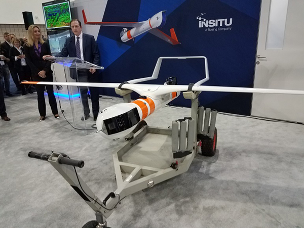
Insitu held a media event at the show to announce its ScanEagle-3 drone system. Esina Alic, the new Insitu CEO, led a team who introduced and then unveiled the new commercial-standard ScanEagle variant.
This new variant has grown out of 20 years of experience and 15 years of working with the FAA to enable integration of drones into the U.S. National Airspace System (NAS). The ScanEagle-3 (SE-3) has been rebuilt with the objective of developing a certifiable vehicle with increased payload and endurance capability that is free of any ITAR restrictions — allowing export without restrictions to the rest of the world.
Insitu unveils the ScanEagle-3 is at Xponential 2018.
SE-3 features include:
Significantly increased (x2) payload
Still provides for full integration of all existing payloads
Commercial, non-ITAR product for the global market
Long-endurance platform
Service contracts available
Product release in Q2 2019
Fully compatible with existing launch and recovery systems
Around ~100 lb without payloads
ScanEagle variants were used in emergency response to the California wildfires at Santa Rosa and Medicina, gathering real-time information for fire-line combatants.
ScanEagle helped fight these wildfires using High Accuracy Photogrammetry (HAP) sensors. Military-grade electro-optical (EO) cameras during daylight and infrared (IR) cameras for night-time imaging extended the time available for tracking fire lines. Penetrating smoke or darkness, these UAVs gathered video and still images that were used to create geo-referenced, high-resolution digital fire progression and suppression maps to guide firefighting on the ground.
This small overview of Xponential 2018 attempts to provide a flavor of the breadth of activity we saw at the show last week. A good portion of this has also been captured through short videos published on the GPS World website, along with news articles.
There is more to come, with a report to follow from the show on Septentrio’s new product releases, Spirent’s GNSS simulation demo, DJI’s overview of drone products featured at the show, CyPhy Works tethered drones, Swift’s announcement of its Skylark correction service trials, Hemisphere’s new Vector Smart Heading Antenna, and Harxon’santennas for drones.
A big show to cover, that’s for sure! It’s a good sign that people were perhaps talking more business than in previous years and a sign that the UAS industry is perhaps moving into its next growth phase.
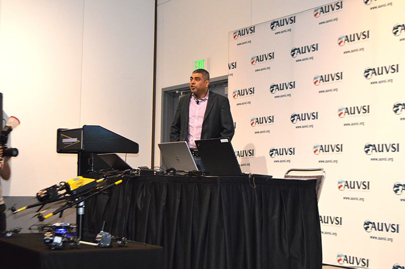
Intel’s Anil Naduri discussed some of the company’s updates at Xponential 2018. Photos by Allison Barwacz
Intel shared a number of updates at a presentation during AUVSI’s Xponential 2018, which took place April 30-May 3 in Denver. Among the company’s latest developments are its Insight Platform, Mission Control and Falcon 8+.
Intel Insight Platform
Intel’s Insight Platform is a digital asset management system that enables aerial data management and analysis. It allows customers to store, share and manage data that commercial drone systems collect. According to the company, the platform is designed to reduce costs, improve efficiency and fuel growth.
The Intel Insight platform takes the aerial data and can generate 2D and 3D models, take measurements and run data analytics.
“The asset-based approach allows you to tag repeated flights over the same location, and that provides a great foundation for you,” said Anil Nanduri, vice president and general manager of the Intel drone team.
Intel Mission Control
Intel’s Mission Control is the company’s next-generation flight planning software for its Falcon 8+ drone. According to the company, it is designed to increase workflow efficiency and enhance automation of drone flights for commercial missions.
Mission Control allows Falcon 8+ drone operators to create 2D and 3D flight plans for commercial surveying, mapping and inspection missions.
Intel Mission Control software is currently in beta testing with customers, Intel said.
Falcon 8+ drone
Intel revealed three new payloads for its Falcon 8+ at Xponential. Photo by Ryan Gerard
During the presentation, Intel revealed three new payloads, as well as distance hold and distance guard features, for its Falcon 8+ drone.
The three new payloads are designed for inspection, surveying and mapping applications. According to Intel, the Falcon 8+ also now boasts distance hold and distance guard features on the Intel Imaging and Duel Imaging payloads. The distance hold feature allows the drone to maintain and hold a set distance from certain obstacles during inspections, and distance guard is another obstacle avoidance feature.
The company also shared how the drone has assisted with natural disasters and safety inspections. The Falcon 8+ played a role in disaster relief for the Sonoma County fires, as well as data recovery following Hurricane Harvey in Houston.
The drone also assisted with a gas terminal inspection in Scotland, as well as with Arctic wildlife research.
“Drones are going to be the most transformative business technology in the coming generation,” Nanduri said.
Honeywell has launched its first commercial unmanned aerial vehicle (UAV) inspection service — the Honeywell InView inspection service — to help industrial customers improve critical structure inspections while helping increase employees’ safety from many of the risks associated with these often-dangerous working conditions.
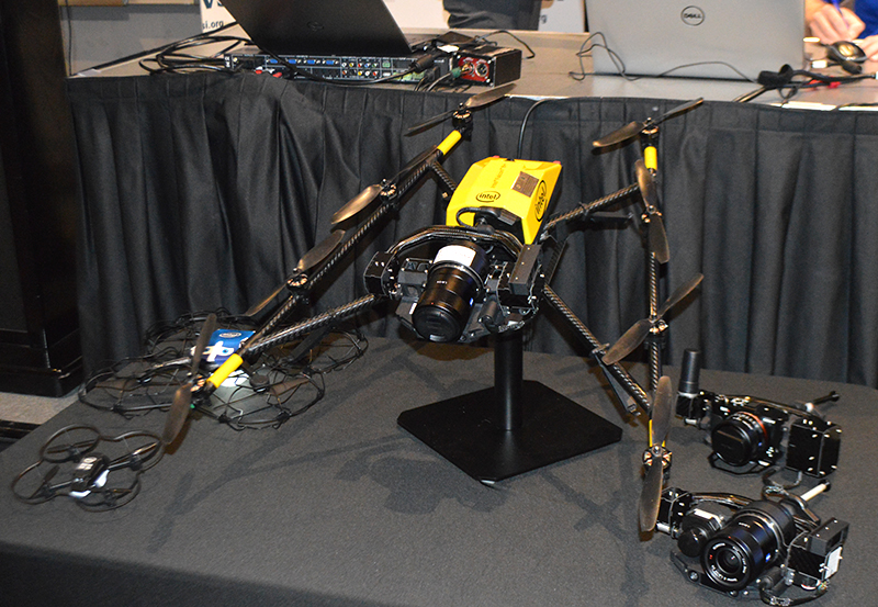
Intel Falcon 8+ octocopter drone.
The Honeywell InView inspection service will combine the proven performance of the Intel Falcon 8+ UAV system and Honeywell’s expertise in the aerospace and industrial industries with data-driven software customized to the needs of the utility, energy, infrastructure, and oil and gas industries, the company said.
The Honeywell InView inspection service package, which includes the components of the UAV, pilot app and customizable web portal, helps customers organize and create standards around their routine and crisis-response inspections.
For example, the Honeywell InView inspection service can help utility customers create routine inspections of transmission and distribution systems that generate data that can be stored, searched and accessed from in the office and out in the field on demand.
“This collaboration combines Intel’s advanced commercial Intel Falcon 8+ UAV system with Honeywell’s leadership in aerospace safety and connectivity to deliver solutions that deliver reliable, efficient and actionable information to utility and industrial customers,” said Carl Esposito, president, Electronic Solutions, Honeywell Aerospace. “Through our extensive industrial experience, our customers will also gain access to Honeywell’s customized software and data solutions that will help them log, analyze, and eventually predict or prevent outages and structural failures, while protecting the men and women called upon to complete these crucial but high-risk jobs.”
“We are incredibly pleased to collaborate with Honeywell on this exciting new business opportunity,” said Anil Nanduri, general manager for Intel’s UAV business group. “The safety, flight precision and robust performance of the Intel Falcon 8+ system are a perfect fit for the Honeywell InView inspection service and will allow its customers to inspect, collect and analyze valuable data in a whole new way.”
With Honeywell’s InView inspection service, customers tap into Honeywell’s experience across vertical segments such as utilities, aerospace, connected building management, and oil and gas technologies.
In collaboration with Intel, Honeywell will utilize the intelligence and experiences of its diverse set of businesses to give customers a comprehensive solution and experience unrivaled in the marketplace.
“Technology, along with the Internet of Things, is enabling utilities around the world to modernize the management of their energy grids,” said Nitin S. Kulkarni, president, Smart Energy, Honeywell Home and Building Technologies. ” Honeywell brings together the technology that allows utilities to transform how energy is consumed in homes and buildings with software-based systems that help safely and efficiently manage complex industrial facilities and utility grids. Honeywell also has more than 100 years of experience providing dependable products and services to a variety of industries, of which Honeywell InView inspection service is the latest entry.”
Inspection Service goals
Keeping workers safe. According to the U.S. Department of Labor, utility line workers have one of the top 10 most dangerous jobs in the United States, with 21.5 annual fatalities from high-voltage lines for every 100,000 workers.
By using the inspection service, utility companies can send a UAV to perform routine inspections of substations, transmission towers and power lines while keeping boots on the ground and workers safe.
For utilities, using a UAV for inspections offers safer and more cost-effective means than existing methods using helicopters, cherry pickers, ladders and walking inspections.
Improving efficiency. Historically, inspections are siloed by organization and by individuals within organizations. Honeywell’s InView inspection service aims to create standardized inspections where customers can create operational efficiencies in the office and out in the field.
Data capture and analysis. UAVs are being touted for their data-gathering capabilities, but without analytics, more data is simply more data. Honeywell’s service can synthesize vast quantities of data to identify only what is needed and actionable, translating workers’ tacit knowledge into valuable information that provides actionable insights for business.
Connected Freight
Honeywell and Intel also recently collaborated to create a Connected Freight platform that gives shippers and logistics companies the unprecedented ability to monitor shipments of high value and perishable goods, helping prevent costly damage and loss.
The new Honeywell InView inspection service continues the work these two companies are doing to help various industries use connected devices to be more efficient and safer, and harness data in new and meaningful ways.
GPS and GNSS have changed the world. Of that there can be no doubt. But in terms of sheer change, both qualitative and quantitative — we ain’t seen nothing yet.
We now witness the creation of an industry. This will be very disruptive. We’ve had change instituted by GNSS; we know what that looks like. We haven’t yet seen a true revolution.This is something entirely new, and there are many things about which we don’t yet have a clue .
What happens to that great American institution, the private car? The relationship between the individual and its four-wheeled extension?
And on the industrial side, do automakers disappear as OEMs — do they become Tier 1 suppliers to Google, Uber and Lyft?
Because of the massive impact of this particular rollout of GNSS-enabled capabilities, I am devoting this issue of the GNSS Design & Test e-newsletter to it, even though it is not in itself a system in space. It is the most radical transformation of life on Earth we have seen, driven by our systems in space.
The following are notes jotted during the Driverless Conference, March 23 in San Francisco.
“In the early 90s, when I was part of a government ride-sharing initiative, we used to talk about these new portable devices bringing data communication into … wherever we go. Now they’re here, and they’re well established. Very soon, this is going to change things, and enable many of the things we’ve only talked and dreamed about so far.” Thus spoke Steve Wollenberg of Automatiks, opening the conference.
“We’re at the confluence of great technological developments. We’re seeing great acceleration of all of them.”
Virtually all the speakers, all these driverless enthusiasts, really love cars. Some own up to collecting them, having multiples in their home garage(s). A bit wistfully, Wollenberg foresaw the new control technology taking over public roadways. “In ten years, racetracks may be the only place where you’re allowed to drive your own vehicle.”
Ride Share. “Four years is the entire lifetime of the ridesharing industry,” said Emily Castor of Lyft, who by virtue of her tenure there for that period, can be termed an industry veteran.
“We’ve seen a full-about turn in the regulatory environment. We see ride-sharing as the stepping stone to a world in which people no longer drive vehicles. Getting an autonomous vehicle on demand through a shared network will be much easier and cheaper than owning a private vehicle.”
Lyft talked with General Motors last year, and found a shared vision of shared use.
Amitai Bin-Nun from Securing America’s Future Energy (SAFE), a non-partisan advocacy organization with business leadership, introduced his organization’s broad mission: reducing U.S. petroleum dependence. Instability in parts of the world is fueled by petroleum dependence.
“This is a hard process. It takes a long time to overturn an established system.” A key obstacle is the lack of compelling new consumer experience, currently. Using connected and autonomous vehicles in a ride-sharing network is an opportunity to get this new experience, and drive the transformative process. Re-order the transportation system.
Mariel Devisa of Travelers Insurance announced that Travelers has launched a ride-share insurance product, live now in 16 states.
In two fairly conservative industries — automotive and insurance — with long-established partners and practices, the efforts to move and change are, frankly, surprising and faster than anticipated, according to moderator Wollenberg. “It’s a fun time.”
Freight and Fleets. Steve Boyd of Peloton made the case that trucking fleets can serve a critical role in pushing the technology forward, because some segments of the transportation industry move faster than others. Getting state approvals without having to go federal is the route pursued now, in terms of full-scale roadtesting of autonomous driving. That will enable early adoption heading into commercial pathways: freight-truck platooning and drafting. Volvo, Intel, Nokia, Denso, UPS and a number of other companies are closely involved.
Boyd announced a set of fleet trials this year, starting in Texas, “a very truck-friendly state.” Legislative approval for trials has passed or is pending in several other states, as many as a dozen. Prospective customers are already lined up in the freight space.
In Europe, an April 6 EU Platooning Challenge will take place in Rotterdam. The Netherlands is leading the EU in the current cycle to approve truck platooning by early 2018.
There’s “a platooning gap” developing between the U.S. and Europe, according to Boyd. Silicon Valley may lead on the technology, but if this is not matched by activity on the regulatory side, it will lose out to other areas that aggressively pursue approvals as well as technology.
Traditionally, the automotive and trucking OEM industries have been very competitive, but now they are seeing the necessity to collaborate to push the policy side forward. This is happening in the insurance industry, too. Competition will certainly still be there, but to enable vehicle-to-vehicle communication a broad measure of collaboration will be necessary.
The road environment today is very imperfect, with many thousands of fatalities and countless more serious injuries. Trucks drive too close together. Highway safety needs innovation and regulatory change in order to improve.
The Long Vision. An autonomous car can’t count on the ability of the driver to retake control of the vehicle in 5 or 10 seconds. So the vehicle needs to be able to take care of itself — fully. Therefore, an evolutionary approach to installing autonomous capabilities may not work.
Some initiatives, however, continue to bring services into the vehicle one by one, gradually. How engaged will the driver be, and in what timeframe? There’s debate, and a shift in thinking may currently be underway.
Traditionally, a 5- to 7-year product cycle in automotive starts when new features are introduced in upmarket vehicles. Examples: adaptive cruise control (to follow the car in front of you at a set distance), lane-keeping assistance. Gradually, these new features are installed in lower price-point models until they become standard throughout the line. With multiple products and product cycles, it will thus take multiple decades. 220 million vehicles are owned by households. An integrative approach to autonomy will take a long, long time.
There is a rising tide for autonomy may take a different approach: autonomy first, that is, full autonomy will take over the vehicle — and as many vehicles as possible.
(Something that no one has mentioned but I can’t help thinking: Given the longstanding and extremely virulent controversy in this country over private gun ownership… What does this bode for something shaping up as a massive social, structural change, not just a new technological wrinkle? What is more American than a gun? A car.
If you thought the Internet, or smartphones, or for heavensakes even GPS/GNSS have radically altered the world — again, we ain’t seen nothin’ yet.)
Intel CEO Brian Krzanich demonstrated the broad capabilities UAV technology during his keynote presentation at the 2016 Consumer Electronics Show Jan. 5, in Las Vegas. Krzanich showcased the Yuneec Typhoon H with Intel RealSense Technology. (Photo: Intel)
Intel has signed a definitive agreement to acquire Ascending Technologies, a drone company located in Krailing, Germany, that produces drone auto-pilot software and algorithms.
Intel has already partnered to combine Ascending Technologies’ sense-and-avoid algorithms with Intel RealSense technology’s real-time depth-sensing capability. These technologies can improve drone safety, helping them avoid obstacles and collisions.
With Ascending Technologies, Intel gains expertise and technology to accelerate the deployment of Intel RealSense technology into the fast-growing drone market segment. The Ascending Technologies team is expected to continue supporting its current customers while also collaborating with Intel’s Perceptual Computing team to develop unmanned aerial vehicle (UAV) technology that can help drones fly with more awareness of their environments.
“Drones are quickly emerging as an important computing platform of the future, writes Josh Walden on an Intel blog. “With practical applications ranging from disaster response, to infrastructure inspection, to delivery of goods, UAVs offer an incredible opportunity for innovation across a multitude of industries. As a result, Intel is positioning itself at the forefront of this opportunity to increasingly integrate the computing, communications, sensor and cloud technology required to make drones smarter and more connected.”
How the Internet of Things Now Drives Location Technology
The number of devices connecting to the Internet is growing fast. The applications running on them require location context to determine the most likely use case. These devices need continuous location — not necessarily noticed or activated by the user, but always on. The specification that becomes important is energy per day: the device must maintain its location without draining its battery — and increase location availability indoors. That creates new design requirements for hybrid capability.
By Greg Turetzky
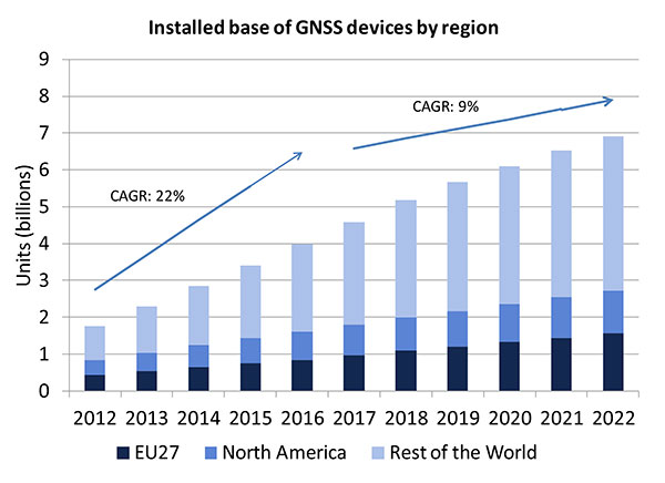
A lot of people have the opinion that the GNSS market is kind of flat. Actually, several different market studies would indicate that it’s not as flat as you would think. See FIGURE 2, taken from the European GNSS Agency’s (GSA’s) 2015 GNSS Market Report. The growth rate certainly is slowing, but any market that continues to grow at a 9 percent annual growth rate is a very nice target area. As you can see, the GSA expects that we’re going to have somewhere in the neighborhood of 7 billion devices within the next eight to ten years.
Figure 2. Installed base of GNSS devices by region; the GNSS market continues to grow at a rapid pace. Source: GSA GNSS Market Report.
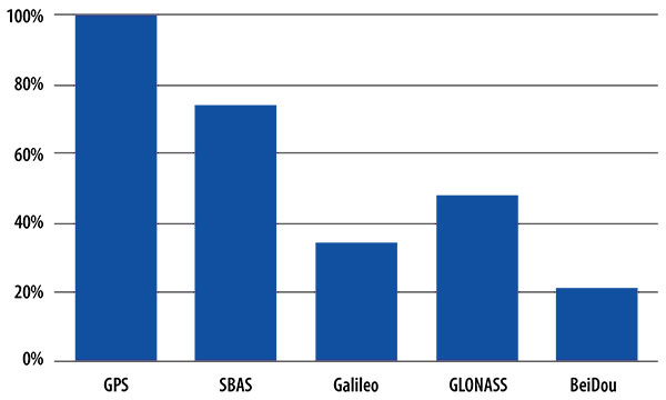
We’re getting to the point where the number of GNSS receivers exceeds the population of the planet, which makes for an interesting thought process as to where GNSS is going to end up, and how it’s going to have to end up in everything that we do. That makes for a nice market opportunity. A big reason for that is we’ve seen a lot of growth in demand for multi-constellation GNSS. Everything pretty much has GPS in it that everyone terms as GNSS, but the growth of these other constellations is happening relatively quickly.
FIGURE 3, in my opinion, is already significantly out of date, even though it is less than a year old. Other market estimates indicate that GLONASS penetration into receivers, especially in the mobile phone field, is closer to 70 or 80 percent today, and that is expected to grow. There’s really no technical or economic reason why GNSS receivers can’t support multiple constellations, even at the consumer mobile device level.
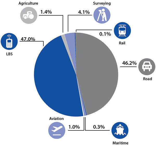
Once all those constellations are in place, let’s look at where those receivers are going from a market standpoint. FIGURE 4 is divided by revenue, which is an interesting way to do it because we all know if you divided it by actual units, then the location-based services (LBS) portions in phones would dominate everything; everything else would just be a sliver that wouldn’t be visible. But if you look at it from a revenue standpoint, there are still many revenue opportunities in the phone segment and in the automotive segment.
Another reason to expect continued market growth is, if you examine Figure 4, you’ll notice that the Internet of Things (IoT) category (see SIDEBAR) doesn’t even show up here. We’ll see going forward that there will be a new slice of pie showing a focus on that segment and those types of applications.
Intel and the Internet of Things
Intel’s mission is no longer only to build PCs. We’re about bringing smart, connected devices to everyone. That encompasses a range of products, and we’ve been expanding our portfolio appropriately.
We start with everything from big iron data centers (which are part of smart devices) to mobile clients and all the way down to the Internet of Things (IoT) and wearable devices. All those devices are part of this smart connected world. Our group’s job is to help on the connectivity side, which varies by product.
This whole idea expands beyond mobile phones and into the IoT, a big trend whose methodology is transforming business, starting at sensors all the way up to big data, to make interesting decisions. The number of devices that are being able to connect to the Internet is growing faster than anybody can keep up with, and that creates a really interesting opportunity. That gives you a bit of a picture as to why Intel is interested in this market and where you’re going to see us playing.
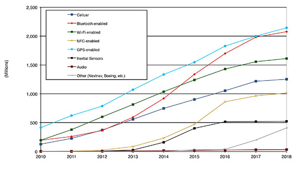
Looking at how we provide this location capability beyond just GNSS, how are people determining their location in these different platforms, and what are the different technologies available? FIGURE 5 shows that in 2014–2015 the most popular technology is still GPS, but there is a fast-growing trend in both Bluetooth-enabled and Wi-Fi-enabled penetration of location technology. Both of these are more suited to indoor operation, where the market is still in its early stages.
Figure 5. Alternative location technology shipments, world market forecast: 2010–2018. Source: ABI Location Technologies Market Data.
Although GNSS continues to grow with market growth, the growth of other technologies and the ability to incorporate them into location solutions is growing pretty quickly, and the radio versions of those are, in general, growing the fastest, followed by the inertial sensors. I think we’re going to see this combination of location technologies, jointly providing a single answer, becoming the norm in mobile products.
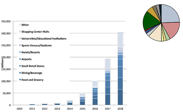
These technologies are going to end up, especially for indoors, in different areas. FIGURE 6 shows a huge growth, not only growth but segmentation among a bunch of different types of venues, all of which seem to be adopting an indoor location methodology. Not all of them will adopt the same one, but all these types of venues are looking at that market and are looking at potential different technologies to serve their needs. What might be most appropriate in a grocery store — geared towards finding a particular item — like a Bluetooth beacon might be less interesting in an airport, where there’s still a need for navigation from place to place, where proximity is not necessarily the right answer.
Figure 6. Indoor location technology installations by vertical market, world market forecast, 2010–2018. Source: ABI.
We see a large growth of a very disparate technology base; at the right of the figure is a pie chart where I had to remove all the callouts, the list of all the different technology suppliers addressing these particular indoor markets. What you see is a highly fragmented supplier base; that’s very consistent with an early market implementation. There’s a lot of different people attempting to get into this market with a lot of different solutions. This is pretty classic for an early-adopter scenario.
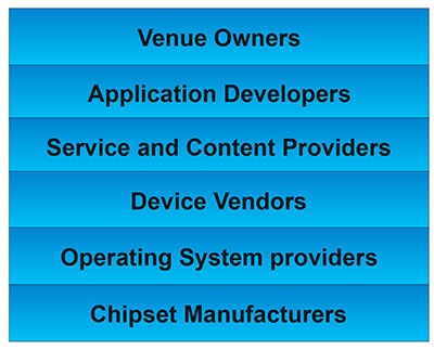
The Stack. Changing accuracy requirements will come up a bit later in this article. Once we’ve looked at where those different venues are from a requirements standpoint, we start to look at the types of companies that are trying to participate in the ecosystem required to do that (FIGURE 7). If you start from the bottom, where I live as a chipset manufacturer, and you move up the chain, you see seven different layers of people in the creation of a location to the end user, especially indoors. And every single person you see in this value chain is trying to make money.
Figure 7. LBS value chain: a highly complex ecosystem with each segment looking to differentiate and monetize indoor location. Source: GSA GNSS Market Report.
That’s the crux of the issue: a lot of people want a piece of that pie, and all of them have a relevant part to play, but when seven people in the stack are all trying to own the location result in order to monetize it, it becomes difficult to create a unified methodology. I live at the bottom of this complex ecosystem, in the technology implementation layer. Getting dollars to flow from the top to the bottom gets relatively difficult, so we are very driven to bring cost competitiveness into this market.
In summary, from a market standpoint, we see that the market opportunity is very big and still growing. This makes it interesting to a company like Intel, even though we aren’t a major player in the business today, to continue to invest in it. We see a trend going from GPS to GNSS and on to location, and now the big opportunity is indoor location. But this indoor-location market is not a stand-alone device opportunity. Indoor location requires this kind of technology inside other devices, inside phones and tablets and IoT types of things.
Context. Let’s look at indoor location as a feature in a larger portion of product. That idea comes from the requirement for location not just for the location itself, but in order to provide context. That’s critical because now these smart, mobile devices are not just used to make phone calls, but are used all the time. As a result, many applications running on them really require that location context to determine the most likely use case that the device is currently operating, making the consumer experience easier and more natural. This is evident throughout the entire value chain from phones and tablets to wearables. If you think about that from a requirement standpoint, you see the major places where GNSS has enabled trend changes in the market.
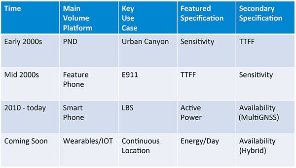
Let’s step back a bit in history to go through FIGURE 1, the opening figure, horizontally. In the early 2000s when I was at SiRF Technology, the main market drivers were personal navigation devices (PNDs). There were all these dashboard-mounted PNDs, and the main things we were trying to fix was the urban-canyon problem. GPS always worked well in the rural areas but always had trouble in urban canyons; to fix that, we had to improve the sensitivity. The solution in that timeframe was with multi-correlator designs and improved RF frontends; we were able to improve the sensitivity of the receivers by a good 5–10 dB, which enabled us to really keep the antennas inside the car so that there was no need for roof-mounted antennas. The PND could be mounted on the dash and work just fine. That was a big factor in improving the user experience. The secondary specification that enabled that market to grow quickly was time-to-first-fix; those devices had to power-up and work fast to prevent user frustration.
Within about five years, however, the PND market was overtaken by growth in the feature phone market. The reason for that was the FCC E911 mandate; everyone had to figure out a way to make sure that phones sold in the United States had the ability to meet that 911 mandate. GPS was one of the major methodologies in meeting that, and the main driver there was not around sensitivity, it was improving first-fix times. The mandate required a 30-second TTFF implementation in a very challenged environment to support emergency-services dispatch. This led us to the development of assisted GPS (AGPS) and further integration into phones. We had a secondary requirement of continuing to improve the sensitivity, because now we had to deal with an even worse antenna in a handset.
Once that was taken care of in the mid 2000s, the next thing we saw coming — and what’s coming now — is the change in GPS requirements for smartphone navigation. This comes from the huge growth of higher end smartphones that are running multiple applications driving the use-cases around LBS. How will the location be used to provide services, now that we can provide applications on that platform? Now the most important specification has become active power? Every time a GPS receiver is turned on for use in an LBS mode, you have to make sure that the power consumption is kept to a minimum, or no one will use those services. So the active power of the device became a very important specification that we were all trying to improve.
The secondary specification we had to improve was the availability. This is where the advantage of multi-GNSS started to show up — using handsets for car navigation on Google map types of implementations. So the performance of smartphone navigation in the urban canyon became a big driver recently as the main use case.
Impacts of New Requirements on Silicon Design
Standby power reduction impacts
SRAM is the leakiest component of typical design
Needs to be reduced or ideally eliminated
Non-continuous fix methods
Ability to quickly save and restore state information
Hybrid location solutions
Support measurements from multiple radios
Need to share radios, not duplicate chains
Increased integration of of multiple radios on single die
Need more interference rejection capability
Ability to support concurrent radio operation on single die
Next! What’s coming next is the idea that these wearables and IoT platforms are not just doing LBS on demand because of the currently active application. They are going to need continuous location. The device needs to provide location capability all the time, but it’s not necessarily going to be noticed by the user or activated by the user, so the specification that becomes important is energy per day. You want to make sure your device can maintain its location without draining its battery. Then we are also going to have to increase the availability of location into indoors to really fix this whole problem. And that will really move us into hybrid capability.
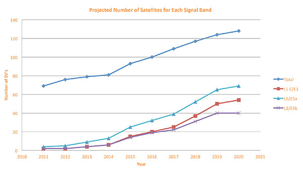
If we look at those changes in the market and we look at how they’re going to impact the GNSS architecture, the first thing we want to look at is: Where is GNSS? FIGURE 8 is a plot that I’m sure everybody has and is hard to keep up to date. It looks at the satellites coming from the different satellite constellations. The important thing here is that we are approaching a timeframe where a significant uptick in the growth of satellites can send the numbers over 100. That can really have an impact on receiver design, if you’re building a multi-GNSS receiver and you have to deal with a hundred satellites. How are you going to do that?
Figure 8. Projected number of satellites for each signal band.
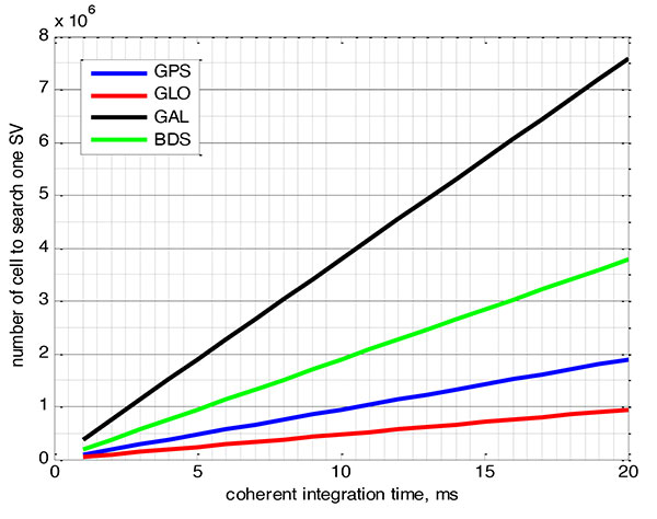
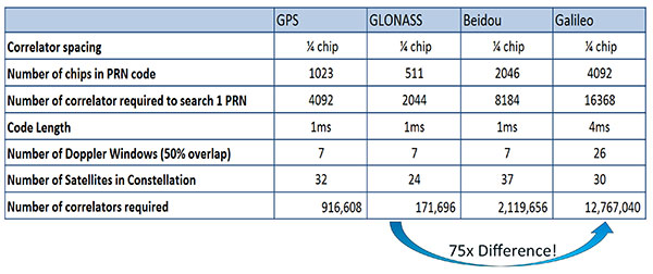
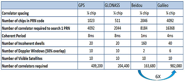
FIGURE 9 shows the relationship between the coherent period and the number of correlators required to search for one satellite in each constellation. We looked at particular scenarios — in this case, let’s say we are trying to do an outdoor location, so –130 dBm cold start test (FIGURE 10) with an initial frequency certainty of around 1 part per million (ppm). We wanted to look at the impact of the different constellations on doing that, and what it takes inside of the receiver to implement it. I’m not going to go into great detail here. But looking at those impacts in correlator counts, you can see the difference between building a GPS receiver that can do this and building a Galileo receiver that can do this. From the simplest one, that is, GLONASS, and from the most difficult one, which is Galileo, you see a 75x difference in the number of correlators required to do that, based on signal structure. This would indicate that, maybe from a cold start fix point of view, you might prefer a GLONASS implementation, and do GPS or Galileo later.
Figure 9. Relationship between the coherent period and number of correlators requried to search for one satellite in each constellation. ±1 ppm local oscillator frequency uncertainty; ±10 kHz Doppler shift range; 50 percent Doppler bin overlap; 1/4-chip correlator spacing.Figure 10. Test scenarios, cold start test.
If that specification was your primary concern, then you would look at how those requirements got implemented into those devices. In addition, you try to come down to these low levels of power consumption, maintain sufficient accuracy to support these applications, and be able to move this into a very small form factor. If we look at the relationship between the number of correlators required to search for each satellite and amount of silicon area that requires, we see a big difference in the growth of those, depending on which constellation you look at. But if you look at a hot start scenario (FIGURE 11) rather than a cold start and at a weaker signal level, which is the more common implementation in devices today, you see a different result. With an improved starting condition because we have better information on the oscillators and reduced other uncertainties producing a smaller search space, the silicon area impact is greatly reduced. Then we have to really look at reducing standby power. That means we need to look at static random-access memory (SRAM) because SRAMs are a horribly leaky component and create very large standby power, but they are what we’ve been using for years in the standalone GPS world.
Figure 11. Test scenarios, hot start test.
We also have to look at non-continuous fix methodologies: this idea of turning things on and off to save power, which relates back to the standby power issues. We also have to look at hybrids: How are we going to support measurements from multiple radios like Wi-Fi and Bluetooth that are becoming important for indoor location? How are we going to share those radios without just pasting them together? That involves integration onto single die, and looking at what happens on the silicon level, and at what happens when you try to run radios at the same time.
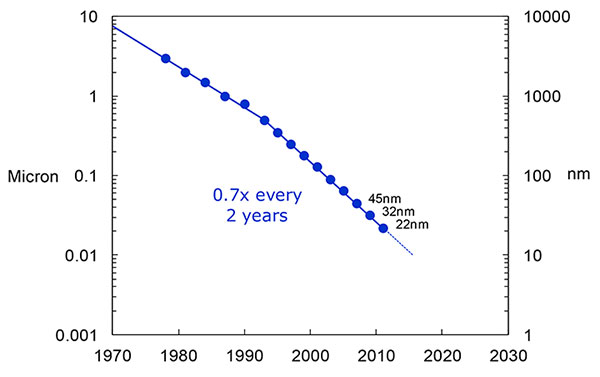
What we have to work with, especially here at Intel, the home of Gordon Moore, is Moore’s Law. It is still working 30 years after it was proposed. Recently, we see that we are tracking this progression of constantly reducing device sizes and moving forward. The dates in FIGURE 12 are for the process technology nodes associated with a classical digital process. We are not at the 22-nanometer level today on GPS receivers, but we are moving down that curve.
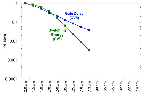
Figure 12. Moore’s Law in action: transistor scaling and improved performance. In GNSS terms, this means more gates and more memory for less cost, improved TTTF and sensitivity by allowing more search capability.Figure 13. Scaling also increases speed and reduces power. HIgher clock speed provides better search and more complex navigation algorithms.
Obviously, when you move down that curve, you greatly increase your ability to add more gates to improve TTFF and sensitivity. More correlators help you search out more uncertainty faster. The other thing this does is allow us to run faster, to up the central processor unit (CPU) clockspeed. This allows more software capability to do things like process more advanced navigation algorithms, bring in more satellites from multiple GNSS, run very expansive Kalman filters, and look at hybrid technologies. It has also driven down the power, so that reducing the active power requirement that we had was kind of coming along with Moore’s law without a whole lot of effort.
But now we’ve run into a problem: the parameter that we care more about, standby power, is actually going up. Although we are getting benefits out of Moore’s Law from speed and active power, we are actually having a problem. It’s increasing our standby power, which makes it difficult to go to these lower fix rates with faster restarts.
You see a trend here. As you move down in technology nodes, you find that the more advanced technology nodes are less applicable to the smaller multi-purpose devices. This is part of the reason why you don’t see the mobile phone devices coming down as fast as you see the desktop devices coming towards those new technology nodes.
This means some really significant silicon design challenges. We need to figure out how to take the advantages of Moore’s Law and maintain the benefits of smaller geometry, we need higher clock-speeds, and we need more memory for multi-constellation methodology and that gets lower active power and smaller size.
But we have to figure out a way to not give up our standby power when we start moving down into these very small geometries. That will require some new methodologies, both at the chip level in terms of how we build silicon, and at the system design level, in terms of how we put these things together inside a mobile phone.
What Intel Is Doing
I can’t tell you what we haven’t done yet, but we look at location as an opportunity where the strength of Intel comes into play. We have very advanced silicon processors and we are bringing those to bear on the location technology problem — just starting in the last few years. Our goal is to provide a GNSS and location silicon solution with best-in-class performance based on Intel technology. Once we’ve done that at the silicon level, we’ll look at bringing the platform-level integration capability together.
We have the ability to merge multiple location technologies. We have a platform-level capability to integrate hardware and software to solve the indoor location problem on a variety of platforms. To execute to Intel’s vision, we’re going to push this into a ubiquitous technology present in all these devices, so that we can improve the variants on these mobile products.
Multiple Radios. That’s part of what’s driving the whole industry towards the kind of consolidation that we’ve seen: stand-alone chipsets are not the only (or even the preferred) way to solve this problem. Without some access to the system design level, we’re not able to solve this problem for mobile phones and IoT type devices. We’re going to see this trend — that we all see coming — of putting multiple radios onto a single die, because that does reduce cost and size as we try to get into watches.
The 2015 Consumer Electronics Show brought out the new stuff. They’re talking about IoT buttons. We still have a ways to go; bringing that capability down to that size in a GNSS radio is a difficult problem. Once we start incorporating these different radios, such as Wi-Fi and Bluetooth, into this solution, we run back into the problem of the value chain: How to get everyone aligned in a device with these capabilities into a single unified solution?
One of the problems a lot of us see with these mobile products is that they have a lot of application and they require a lot of interaction. We’d all like these devices to become smarter and present the information that we want, when we want it. A big part of that is the location context, and so that’s what we’re planning on doing: integrating that location context into all these platforms so that these smart connected devices can be even smarter and provide a better user experience.
GREG TURETZKY is a principal engineer at Intel responsible for strategic business development in Intel’s Wireless Communication Group focusing on location. He has more than 25 years of experience in the GNSS industry at JHU-APL, Stanford Telecom, Trimble, SiRF and CSR. He is a member of GPS World’s Editorial Advisory Board.
The statements, views, and opinions presented in this article are those of the author and are not endorsed by, nor do they necessarily reflect, the opinions of the author’s present and/or former employers or any other organization with whom the author may be associated.
This article is based on a GPS World webinar, which sprang from a presentation at the Stanford PNT Symposium. Listener questions and Greg Turetzky’s answers during the webinar, which can be read here.
The author would like to acknowledge the contribution of Figures 9, 10 and 11 from the paper “Optimal search strategy in a multi-constellatoin environment” by Intel colleagues Anyaegbu et al, from ION GNSS+ 2015.
This year’s Mobile World Congress in Barcelona was the biggest ever, with 95,000 attendees and thousands of booths, conferences and people with sore feet walking a cavernous exhibition hall. While the Geneva Auto Show ran close to the same dates, connected vehicle companies and technology were prominently featured. What was interesting, however, was the rise of indoor positioning companies and mobile advertising agencies with interest in location.
BARCELONA — Joining the 95,000 or so Mobile World Congress attendees were about three dozen companies who are offering indoor location and location advertising services. These companies have exhibited at previous conferences, but not in the numbers this year.
At the huge Fira convention center where MWC was held March 2-5, Los Altos, Calif.-based Pole Star installed more than 600 beacons for indoor location. Visitors were able to be guided to booths and other areas through an interactive map. “Business was good in 2014, we sold 10,000 beacons. We are making money,” said Christian Carle, Pole Star CEO.
One analyst said that the big change at MWC wasn’t the number of indoor positioning companies and demos, but the maturity and breadth of the technology. “Intel announced indoor positioning capabilities in their Wi-Fi chip, and had a demo that was very impressive. Many smaller companies that in past years were showing raw technology were showing polished solutions this year, such as Quuppa, MTI and Sensewhere, said Bruce Krulwich, Grizzly Analytics president, who has authored a report identifying 150 indoor positioning companies. “I definitely see a shake-out coming up, but it won’t be one technology prevailing over another. Different technologies meet different needs in the industry, and different technologies fit different sites. There are technologies that deliver universal indoor positioning, without any infrastructure or preparation, such as Wi-Fi multilateration and sensor fusion.”
Krulwich said that there is a shake-out that’s already started because there are too many companies working on similar technologies. “Start-ups in the area that don’t have differentiating innovation, don’t have integration into retail or other back-end systems, and don’t have market penetration, are already finding themselves in a challenge. But companies with clear innovations and commercial deployments will do fine,” he said.
United Kingdom-based Sensewhere is using crowdsourcing in its indoor positioning software. The software uses radios to scan for Wi-Fi and Bluetooth to allow an IP location to reference the sources and form a location database.
“It’s what we call the universal indoor positioning versus venue specific indoor positioning, which can work anywhere — we just need a crowd of people. Our target partners are handset manufacturers, network operators, social media, social network providers, and also chipset guys as well,” said Rob Palfreyman, Sensewhere CEO. “So, there are obviously a lot of companies like Google looking at venues; there is Micello and TomTom looking at add-ins in the indoor location, which is great news, but it just needs to have a technology that can drive the blue dot on their map, and we feel that Sensewhere is the right place to provide that blue dot because of the crowdsourcing global nature of our approach.”
One company, which has developed a popular mobile game, is using its network to attract advertisers for its location-based ad platform. “We already have the infrastructure in place because of our mobile game. With our platform, we can allow advertisers to launch campaigns using our beacon signals and geofencing,” said Pedro Jahara, CEO of Brazil-based RevMob.
New location technology like the ability to track SIM cards was rolled out at MWC. W-Locate, which is partnering with Morpho in Thailand, is tracking SIM cards with its XimLoc product, which the company said is more accurate indoors than other technology.
Even such companies as Geotab, which is a strong player in the fleet market, are leveraging MWC to continue a foothold in the European market. The company displayed its IOX-CAN system that can send data from a mobile device to the MyGeotab system, which can be viewed an analyzed by fleet managers, said Maria Sotra, Geotab marketing manager.
Geotab also partnered with Telefonica in November 2014 to focus efforts in Spain, Germany and the United Kingdom, Sotra said.
At MWC, location-based advertising market is gaining traction as advertisers are seeing the benefit of locating and attracting customers. New York-based xAd said it has doubled its revenue for the second year. “We have billions of mobile ads processed and billions of ad impressions. The company is profitable,” said Dipanshu Sharma, xAd founder and CEO.
He said the company has expanded into France and Germany and added China to its global ad network.
Another company that is using location technology as a differentiator is Airpush, which had another big presence at MWC. The company’s Abstract Banners was a big draw to attendees. Location, particularly geofenced areas, have created a call to action for consumers, which is attractive to advertisers, said Cameron Peeples, Airpush vice president of marketing.
Connected Car Still Big Opportunity at MWC
Although the Geneva Auto Show was starting as the MWC was ending, there were still several big announcements by connected car companies in Barcelona. Even the well-publicized Samsung S6 and S6 Edge and HTC One M9 handset rollouts included Mirrorlink, the connected vehicle standard from the Connected Car Consortium.
In another big announcement, Audi and AT&T said that all 2016 model vehicles equipped with Audi connect will come with the carrier’s 4G LTE or 3G coverage. This increase in services is big because the auto giant just rolled out 4G AT&T service in Audi A3s last year.
AT&T selected Airbiquity to provide end-user registration and device management connected vehicle services for select customer programs. “Airbiquity will deliver these services to AT&T using our Choreo cloud-based connected vehicle services delivery platform and project management, engineering, and operations teams,” said David Jumpa, Airbiquity chief revenue officer. “This is a ‘white label’ agreement whereby AT&T will integrate Airbiquity’s service delivery capability into AT&T’s connected vehicle customer solutions.”
Another location company is making huge inroads in connected vehicle markets with its Glympse for Autos product. Glympse will be installed in select Volkswagen and Peugeot models through MirrorLink, said Bryan Trussel, company co-founder and CEO.
The app allows users to share location from their vehicle by setting the recipient and timer, and hitting send. The company has a similar app for Gogo inflight aviation networks to allow a person on the ground to know where an airplane is for picking up passengers.
In other connected car news, Accenture is providing Fiat Chrysler Automobiles the capability of in-car, Internet-based services. Starting with the new Fiat 500X, Uconnect Live services, which was co-developed by Accenture, will power an infotainment system that offers music and news services, social network access, the ability to monitor driving style and a range of diagnostic services.
Accenture also partnered with Visa for an IoT-based connected car commerce test. At MWC, the company tested a scenario where drivers could order food from the car using cellular, Bluetooth and beacon connectivity. Accenture deployed a similar system with BMW’s ConnectedDrive, which allows customers to choose services in real time for a vehicle.
Health Market Even Has Location Potential
Niche location applications are growing as Internet of Things, or IoT, markets start to grow. One company taking advantage of the mobile market is Annapolis, Md.-based TCS, which featured its VirtuMedix platform in its MWC booth.
The platform is tailored to emergency physicians as part of the growing market for video telemedicine products and mobile health, said Jay Whitehurst, TCS commercial software group president. “It’s already saving lives,” he said of the platform, which combines encryption, navigation, mapping and messaging.
While the product, now being rolled out in a North Carolina emergency medicine group, provides patients with an alternative to urgent care centers and emergency rooms, it also can be used for longer term cases such as assisted living and rehab centers, the company said.
Whitehurst said TCS has made several company acquisitions that have played a part in new product rollouts, which include the company’s Trusted Location. The application allows financial firms, online gaming companies and others to identify and prevent credit-card fraud. The application identifies and validates a device’s location worldwide.
In other Mobile World Congress news:
Spirent said its simulators have the capability to evaluate Wi-Fi Offload and Wi-Fi performance of mobile devices on its test framework. The new product allows companies to test multiple devices on a single unit to cover Wi-Fi/LTE mobility and interoperability. The testing is important in light of wireless carriers’ strategy to extend VoLTE in areas where cell coverage is limited, said Saul Einbinder, Spirent vice president, venture development.
Google Waze said its Google Mobile Service (GMS) will be available as a preinstall option on mobile devices. OEMs and carriers can preinstall the app on their handsets so consumers can use the service immediately, the company said.
Trimble’s ALK said its ALK Maps and route visualization software is now available in Europe. ALK Maps, launched in the United States in 2012, allows users to overlay routing, geocoding points, weather and other features, the company said.
Intel has commercially launched the XMM 6255 modem to provide a wireless solution for the billions of “smart” and connected devices that are expected in the coming years. At about 300 square millimeters, Intel says it is the world’s smallest standalone 3G modem, designed for networked sensors and other Internet of Things applications such as wearables, security devices and industrial equipment.
The XMM 6255 features the SMARTI UE2p transceiver, which is based on the new Intel Power Transceiver technology, a design that combines transmit and receive functionality with a fully integrated power amplifier and power management on a single chip. This design approach reduces XMM 6255’s component requirements, resulting in a smaller modem that helps manufacturers minimize their build of material costs. It also protects the radio from overheating, voltage peaks and damage under tough usage conditions, which is important for safety monitors and other critical IoT devices.
Additionally, the XMM 6255 modem features a radio architecture that enables it to perform exceptionally well in challenging real-world situations, including:
Low signal network coverage: The XMM 6255 modem provides reliable communication when it comes to transmitting information in low signal zones like a parking garage or a home basement.
Small-sized devices: Devices with a small form factor like a smartwatch or a sensor may not have enough space for a normal-sized 3G antenna, which can affect connectivity quality and reliability. The XMM 6255 modem is specially designed for such devices and delivers great 3G connectivity even with small volume antennas not meeting conventional mobile phone quality standards.
The integration of the power amplifier and transceiver in this modem simplifies the design and minimizes device development costs, which means developers can launch more products more quickly, and in a more cost-effective manner.
The XMM 6255 is available in the u-blox SARA-U2 module and Intel expects to have additional partnerships in the coming months.