“Seen & Heard” is a monthly feature of GPS World magazine, traveling the world to capture interesting and unusual news stories involving the GNSS/PNT industry.
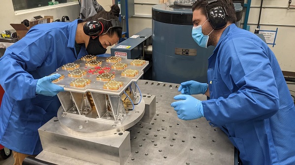
Xona’s first demonstration mission successfully completed testing at Experior Laboratories and prepares for launch on a Falcon 9 in May. (Photo: Xona)
TAKING GNSS PRIVATE
At press time, Xona Space Systems’ first in-space demonstrator satellite, named Huginn, was ready to launch on May 25 aboard Space X’s Transporter 5 mission. Xona said the launch is a significant step toward realizing its high-performance commercial navigation system, a constellation of small, powerful satellites in low Earth orbit that will meet the navigation and timing needs of intelligent systems.
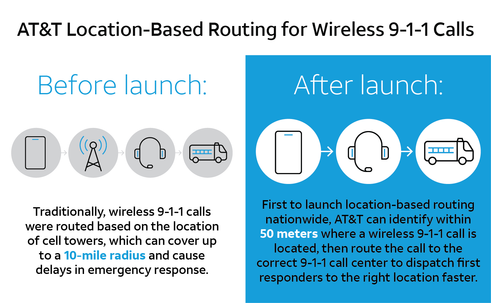
U.S. cellular carrier AT&T is rolling out location-based routing to automatically transmit wireless 9-1-1 calls to the appropriate call centers, rather than relying on which cell tower handles the call. Cell towers can cover a 10-mile radius, and overlap with more than one call-center boundary. With location-based routing, a device can be located and routed within 50 meters of the device location. The “Locate Before Route” feature from Intrado enables AT&T to use device GNSS and hybrid information to route the call to the right call center.
Russian jets have been found using GPS receivers, while ground vehicles use paper maps, according to the UK Express. The GPS receivers were found taped to the dashboards of Russian SU-34s downed in Ukraine because of “the poor quality of their own systems,” UK Defense Secretary Ben Wallace said in a speech. With many reports of maintenance and aging issues for the Russian military, most likely the jets did not have quality GNSS receivers rather than the fault lying with GLONASS.
A Russian short-range ballistic missile, believed to be an unexploded Iskander missile, was found near Kramatorsk, Ukraine, in this photo released March 9 by Ukrainian authorities. (Photo: National Guard of Ukraine handout via Reuters)
UNEXPLODED BOMBS MAPPED
The HALO Trust is partnering with Esri to map unexploded ordnance in an immediate humanitarian response to the war in Ukraine. More than 10 million Ukrainians have been displaced by the war and many are forced to move across a landscape littered with unexploded rockets, bombs and landmines. In response, Esri has committed its cutting-edge geographic information system (GIS) software resources, expertise and staffing in support of HALO’s mission in Ukraine. HALO already is using GIS to map the heaviest conflict zones, and the partnership with HALO will support planning for future clearance operations.
U.S. cellular carrier AT&T is rolling out location-based routing to automatically transmit wireless 9-1-1 calls to the appropriate call centers.
Traditionally, wireless 9-1-1 calls were routed based on the location of cell towers, which can cover up to a 10-mile radius. This can cause delays in emergency response, especially when a call is made where state, county or city boundaries overlap.
With location-based routing, a device can be located and routed within 50 meters of the device location. Through a new “Locate Before Route” feature from Intrado, AT&T can quickly and more accurately identify where a wireless 9-1-1 call is coming from using device GNSS and hybrid information to route the call to the correct 9-1-1 call center.
Graphic: 911
The nationwide rollout has started and is available in Alaska, Colorado, Hawaii, Idaho, Montana, Oregon, Washington, Wyoming, Kansas, Illinois, Iowa, Minnesota, North Dakota, Missouri, Nebraska, South Dakota and Guam. Additional regions will be rolled out over the next several weeks. The nationwide rollout is scheduled to be completed by the end of June.
Reasons Cited Include Privacy, Lack of Retail Support
Kevin Dennehy
Google Here, a proposed beacon-based location service operating within Google Maps, was reportedly cancelled due to a concern by Alphabet CEO Larry Page’s that it would be too invasive by the users of his mapping service. When the location industry has such a dominant player pull out of a nascent, and potentially lucrative, proximity service, does it mean that consumers will now have to wait for a full-scale rollout? Google will remain a major player with its Google Maps app, but where does it go from there?
Citing privacy issues and lack of retail partners for support, Google scraped its Google Here location service that would have used the company’s Maps technology to send notifications to users when they entered a specific location.
In a recent Fortune article, Alphabet CEO Larry Page said the company killed the project because it was too invasive to consumers, and the company was uncertain whether retail partners could have helped to roll out the service. Besides being in conflict with an existing location Here name (such as the former Nokia, and now German consortium, mapping service), the service included partnerships with retailers — and would have been available to more than 350 million Android users earlier this year.
Google makes money off of advertising through its Maps app, but the Fortune article said that the proposed Here location service would have made it even more valuable to advertisers.
So what does the location industry make of one of the largest players not rolling out a location service? To at least one analyst, it’s a “so what” report considering Google in July rolled out a new agnostic beacon service called Eddystone. “Somewhat curiously, the company appears to be moving forward with location-based advertising under the guise of the Eddystone project, so beacons and their use in location-based advertising seem still of interest — just not beacons combined with messaging that might make Google Maps an uncontrollable nag about shopping opportunities,” said Mike Dobson, Telemapics president.
Eddystone, a new format for Bluetooth Low Energy beacons, works with Google’s Android operating system along with Apple’s iOS and other platforms that connect through BLE.
Overall, Dobson believes that Google is approaching middle-age in terms of corporate development. “It is both developing a conscience about how its services really operate, as well as imposing economic constraints limiting how much the company is willing to spend to determine whether a potential market might be a big hit,” he said. “More specifically, it is my opinion that Google is slowly reining in the spending on new innovations for Google Maps, as well as the expenses associated with supporting the lakes in the data reservoir associated with their mapping product. Google may have finally realized that maintaining spatial data is expensive and a cost that is never going to decrease.”
Dobson also said that the Google Here program was going to be an expensive proposition. “My understanding of the Google Here program was that Google would provide the beacons and infrastructure and control delivery of the service through Google Maps. That’s a lot of beacons and associated support — in other words, more money,” he said. “Conversely, Eddystone appears to offer a standardized, industry-supported approach that is beneficial for Google and companies interested in testing the concept.”
Dobson said the name “Here” could have caused problems for Google. “Two other issues crossed my mind when I heard the news of the cancellation. First, who at Google forgot trademark law and thought they could combine the name of the well-known mapping company Here with Google?” he said. “Second, if I owned an application as successful as Google Maps is on mobile phones, I sure would not want to push my users to consider switching to a less-invasive mapping app. You know, that Larry Page guy sure seems to know his Alphabet.”
Big Competitors Getting into Beacons, with Huge Market Expected
Recent Allied Business Intelligence reports indicate that BLE beacon shipments will exceed 400 million units by 2020. While optimistic, and only five years away, ABI said that pure beacon shipment revenues will break $1 billion this year.
Google’s July entry into the location-beacon space is significant, if not surprising, to heat up the location market. However, competition is fierce as Apple, Facebook and Twitter now have dedicated BLE resources.
The location-beacon market is heating up as Gimbal, the Qualcomm spin-off company, installed approximately 1,300 BLE beacons in areas at South by Southwest. Gimbal said it was making its technology available to enable any BLE device to act as a dedicated location beacon.
Google plans to improve its own products and services through the Eddystone beacon technology, according to a company blog. Earlier this year, the company launched beacon-based transit notifications in Portland that enable users to get faster access to schedules for specific locations.
With rise in commercial location-based beacon technology comes a cross-over movement in public safety markets. TeleCommunication Systems, which bought Loctronix in July, is developing the indoor public safety and emergency market, along with Longmont, Colo.-based Intrado.
As detailed in last month’s Wireless LBS Insider column, beacons and Wi-Fi seem to be the lead technologies in use for emergency indoor location. Intrado installed 65 Apple iBeacons at the Washington Convention Center to showcase its developing indoor positioning technology at the APCO trade show.
It’s not all about beacons in this proximity/contextual location market. The analytical data derived from the beacon information will grow into a huge market. As we reported this summer, a new location analytics product is hitting the market in a more and more crowded indoor-positioning field.
Such companies as Cloud4Wi, with its Fogsense product, is tailored to retail outlets, coffee shops, restaurant chains and shopping malls with presence analytics and location-based services.
The device, which contains Broadcom’s WICED chip, features BLE technology in the new version in (the fourth quarter), said Elena Briola, Cloud4Wi’s chief marketing officer. The new BLE version will enable Apple iBeacon and location-aware mobile applications, the company said.