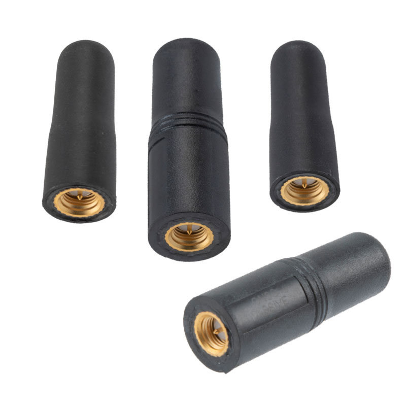
Pasternack has released a series of GNSS antennas that meet military specifications for use in several small form factor and mobile applications.
The mil-spec GNSS antennas are engineered for environmental performance according to the MIL-STD-810G standard and include multi-standard GPS L1, Galileo E1 and GLONASS options.
The MIL-STD-810G GNSS antennas are IP67 rated. They are available in passive and active versions and provide coverage from 1,597 MHz to 1,607 MHz. The GNSS antennas feature linear polarization for cross-polarized isolation, nominal gain options of -3 dBic and 10 dBic, and SMA mounts.
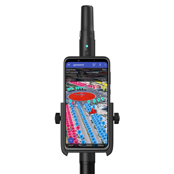
Geometer International, a Ukrainian developer of GNSS/RTK instruments and applications for satellite positioning, has introduced the Walker RTK, a dual-frequency L1, L2 RTK receiver in the compact form factor of a portable RTK device.
The Walker RTK is a lightweight, small-sized, affordable and full-featured device for collecting, storing and processing geo-referenced data on the survey site. According to the developer, a GNSS receiver in a convenient and affordable format will significantly expand the use of RTK technology. The new technology will be suited to most tasks requiring centimeter precision positioning and measurements in a 3D coordinate system.
Compact and lightweight, Walker RTK is the ideal solution for field workers working away from the office. The new device can be operated with just one hand, significantly improving the productivity of service personnel.
Possible applications for GNSS Walker RTK include surveying, utilities, solar power plant engineering, trenching and pipeline installation, drilling, forestry and municipal infrastructure control.
What’s under the bonnet of Walker RTK?
The Walker RTK is built around a 2-frequency L1/L2 184 channel board and a sensitive Helix antenna, satisfying up to 90% of basic user requirements. The tube-shaped housing geometry allows it to fit with any universal mount. The receiver weight is only 0.25g (0.470 with smartphone holder) due to the aluminum alloy housing with a protective coating. The Walker RTK has a built-in Li-Ion battery with enough power for 24 hours of continuous operation without additional recharging. The new energy-efficient architecture of the unit achieves this.
The GNSS receiver has the minimum amount of leading interfaces, resulting in high IP67 dust and waterproof rating. The device can be paired with a smartphone or tablet via Bluetooth, while connection via Bluetooth low energy is also planned for a future release.
Compatible with satellite systems
Walker RTK can track and determine geo-position using signals from all known existing satellite systems. This feature makes it possible to achieve the centimeter-level accuracy of an RTK solution within seconds.
GNSS signals processed by the Walker RTK GNSS receiver:
Thanks to NMEA messaging, the Walker RTK GNSS receiver is fully compatible with any professional or freeware geolocation software, providing high accuracy and reliable RTK-corrected positioning.
ComNav Technology Ltd. has released the N2 Palm RTK GNSS receiver. The release coincides with the company’s 10th anniversary. With its advanced technologies, the N2 is suitable for surveying, mapping and construction.
The N2 has a highly integrated main board and a three-in-one antenna, yet is extremely thin and portable, weighing about the same as a basketball (0.72 kg with battery) and measuring 48 mm, the thickness of AirPods.
Powered by ComNav’s SinoGNSS K8 high-precision module, the N2 can track 1,590 channels, including all existing and planned signals of GPS, BDS-2, BDS-3, GLONASS, Galileo, QZSS and SBAS. Its advanced satellite-tracking technology ensures it works well even in harsh environments, such as under heavy foliage or close to buildings.
A third-generation inertial measurement unit (IMU) makes the N2 immune to magnetic disturbance, which greatly improves its reliability. Pole-tilt compensation of up to 60° allows surveyors to locate difficult points precisely and easily while maintaining positioning accuracy within 2.5 cm. By using the company’s Quantum algorithm, the N2 achieves calibration-free operation — after 10 seconds of initialization, users can make tilt measurements with centimeter-level accuracy for an extended period, greatly improving efficiency.
With its integrated UHF modem, the N2 can reach a working range of up to 15 km. It can be used as either a base station or a rover.
The N2 features a 10,000 mAh intelligent Li-ion battery, along with ComNav’s patented low-power-consumption technology. It fully charges in five hours and works continuously in the field for 20 hours. The built-in USB-C port makes it convenient to charge with standard smartphone chargers or external power banks.
As with ComNav’s other products, the N2 meets ComNav’s high quality and durability standards; it is rated IP67 (dustproof and waterproof) and can work in temperatures from –35° C to +65° C. It can be used in a wider range of outdoor working conditions.
With near-field communication (NFC), the N2 can connect to other NFC-enabled devices, such as the R60 data collector. V5.0 dual-mode Bluetooth inside allows users to connect at ultra-long distances with low energy requirements.
The N2 Palm RTK GNSS receiver now is available through ComNav Technology authorized local distributors or directly from ComNav Technology.
Flanders uses Septentrio receivers to guide automated blasthole drills, such as at this South African mine run by AngloGold Ashanti. Photo: Anglogold Ashanti/Flanders
Flanders, a U.S.-based company with expertise in electrical machinery and control systems, has developed its proprietary ARDVARC advanced drill-rig control system to control mine-drilling machines, making them safer and more efficient. The drill rigs equipped with ARDVARC create holes with centimeter precision. This ensures optimal rock fragmentation, simplifying and expediting subsequent jobs such as stone extraction and removal.
Mines close to the poles or to the magnetic equator, such as those in the Amazon, are challenging for GNSS receivers because they tend to experience the most intense ionospheric scintillations, resulting from rapid fluctuations in the electron density in the ionosphere. These scintillations affect GNSS signals that travel from space to Earth, causing degradation of positioning accuracy or even positioning loss.
To address this challenge, ARDVARC uses Septentrio AsteRx-U GNSS receivers. They are housed in a tough IP67 enclosure and run Septentrio’s proprietary GNSS+ algorithms including IONO+, which ensures high-accuracy positioning even during ionospheric scintillations.
ARDVARC’s benefits include a faster drill cycle time, increased drill hole location precision, increased drill-rig component operating life, improved fragmentation and greater operator safety. The system is available in several levels.
The Intelli-rig manual control system also delivers data on the position of each blast hole, the machine operation and the drilling conditions; it incorporates mine-planning functionality using the mine’s existing or Flanders’ optional GPS equipment.
One-touch converts a manually operated machine to one operated with a single touch, increasing productivity. Once the machine operator positions the drill rig over the desired target, One-touch initiates the automated drilling process, which includes machine leveling, hole collaring, drilling to elevation and angle, rod handling, bit retraction and jack reset.
The fully autonomous drilling solution removes the operator from the cab, allowing one operator to monitor multiple drilling operations from a safe distance. The solution increases productivity by enabling drilling during blasting and shift changes. It uses Flanders’ HazCam to monitor the surroundings, preventing the drill from operating in unsafe conditions.
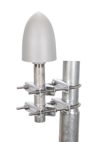
The GP-L1-32-T-MNT GPS timing antenna with mount included, RHCP polarized, 1.571 to 1.61 GHz. (Photo: RadioWaves)
RadioWaves, an Infinite Electronics brand and a manufacturer of high-quality microwave antennas and accessories, has released a new series of GPS/GNSS timing antennas that cover L1 and L5 GPS bands.
The new series of GPS/GNSS timing antennas provide axial ratio and higher accuracy for the reception of satellite timing signals and reference frequencies for enhanced phase synchronization in precision network deployments.
The high gain, low noise figure of 2 dB and high out-of-band rejection provided by these antennas allows for the use of longer and cost-effective cables for easy and flexible installs. They also feature a VSWR less than 1.8:1 and are compatible with several existing mounting brackets. In addition, thee fully ruggedized, weather-sealed antennas are IP67 compliant for use in outdoor and marine environments.
The antennas come equipped with built-in surge protection and support a wide range of GNSS including GPS, GLONASS, BeiDou and Galileo, as well as Iridium. Increased position accuracy in densely populated urban areas, flexible installation, and improved system security make RadioWaves’ latest antenna offering a valuable system component, the company said.
Models include
GP-L1-L5-40-N, an L1+L5 GPS timing antenna, 1.166 to 1.218 GHz and 1.559 to 1.606 GHz
GP-L1-32-T, a L1 GPS timing antenna, RHCP polarized, 1.574 to 1.61 GHz
GP-L1-32-T-MNT, an L1 GPS timing antenna with mount included, RHCP Polarized, 1.571 to 1.61 GHz.
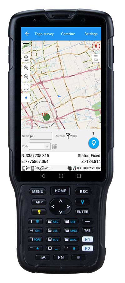
ComNav Technology has released the new-generation data collector R550.
With its new industrial-level design and new hardware platform, the R550 is designed to ensure efficiency and productivity in the field.
The IP67 dust-and-waterproof rating protects the R550 from most harsh environments. Equipping it with 7,000 mA Li-ion battery allows more than 14 hours of continuous operation, while fast-charging technology means it only takes four hours to fully charge the collector via the type-C interface port.
The 5-inch-wide sunlight-readable, high-resolution screen provides a smooth experience for any operation. The integrated autofocusing camera helps enhance job documentation by taking photos on site and sharing job information with colleagues.
Survey Master field software available on the R550 controller ensures efficient surveys in the field, including topographic surveys, stakeouts, coordinate geometry (COGO) and more.
Powered by the Android 8.1 operating system and designed with 4G RAM, 64GB ROM and 4G/BT/Wi-Fi on board, users can run other third-party apps based on their specific requirements.
The R550 data collector now is available through ComNav Technology authorized local distributors or ComNav Technology directly.
Sokkia has unveiled a new radio modem designed to offer advanced radio connectivity with GNSS receivers. The R4S-BT UHF radio provides an external option for use with the Sokkia GCX receiver line.
The UHF multichannel radio modem has a tuning range of up to 70 MHz. Additionally, the radio features an IP67 certified housing with internal batteries that is designed to be easy to carry with versatile mounting options.
“The R4S-BT makes the GCX GNSS receiver into an even more scalable and modular solution,” said Jason Hallett, vice president of global product management at Sokkia. “It is perfect in situations without a network connection or when long-range Bluetooth technology is not enough on its own. Survey and mapping professionals can simply add on this external UHF and extend the range between the base and rover.”
Connectivity options include wireless data transfer and USB connections.
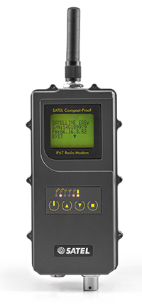
Satel’s new UHF radio data modem Compact-Proof, designed for outdoor measurement applications, features autonomous rechargeable battery power and a robust housing with IP67 protection.
Compact-Proof from Satel gives users double advantages with a powerful lithium-ion battery and the EASy radio data technology including a display and a robust housing with IP67 protection, the company said. With transmitting power of 1,000 mW, it can be operated fully autonomously as a repeater station in the field for more than 15 hours. The power can also be supplied parallel via an external rechargeable battery with a solar panel; alternatively, the Compact-Proof can be recharged overnight, and within five hours it is ready for the next work day.
The user-friendly installation, robust IP67 housing and 4-pin and 8-pin ODU connections make the new radio data modem Compact-Proof attractive for measurement applications, Satel said. The device features all functions of the Satel radio data modems EASy and 3AS and is 100 percent compatible with these solutions.
In addition, it supports the radio protocols of Pacific Crest, Trimble and other GNSS providers, which expands the areas of application.
Whether in the rainforests of Vietnam or in the Arctic, the temperature range of -30°C to +65°C and the frequency ranges of 330 MHz…420 MHz and 403 MHz…473 MHz make the Compact-Proof a reliable partner for all outdoor applications, Satel said. The housing features a robust, compact design with a display and foil keyboard.
As a light version — without an internal battery — the device offers numerous advantages for outdoor applications and even withstands the harsh conditions of machine control environments, for example.
In Germany, radio data transmission solutions from Satel are distributed exclusively by systems provider Welotec.
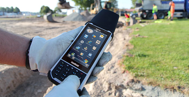
Handheld Group is offering expansion pack features for its Nautiz X8 rugged field computer. The new functionalities will make the Nautiz X8 more versatile for field workers in a number of market segments, including forestry, surveying, construction, field services, warehouse projects and logistics.
The Nautiz X8 was built to enable efficient and reliable data collection in the toughest of environments. Ultra-rugged with superior processing power, screen size and sunlight visibility, the X8 is used in the GIS, land surveying, public safety, forestry and military sectors.
Handheld now offers three expansion packs for the Nautiz X8:
Nautiz X8 Long Range Bluetooth (LRBT) Expansion Pack features a LRBT u-blox module, which allows long-range communication up to 300 meters. This option is especially well-suited for advanced forestry solutions, surveying and construction work.
Nautiz X8 Barcode Expansion Pack features an imager module (Zebra SE4750SR) with an LED aimer, which allows for competitive scanning performance without sacrificing design, ruggedness or user experience. This option is ideal for workers in field service, warehouse projects and logistics.
Nautiz X8 Basic Expansion Pack is an empty add-on cap for an extension of your choice. It increases the Nautiz X8’s customizability and flexibility for specific customer requirements. It also allows users to install custom accessories under the cap using the proprietary interface.
The new Nautiz X8 expansion packs will be available in September. All cap versions are designed to retain the Nautiz X8 IP67 classification.
“The Nautiz X8 is the world’s best rugged handheld computer, with an outstanding screen and exceptional durability, connectivity, processing power and battery life — without compromising ergonomics or design,” said Jerker Hellström, CEO of Handheld Group. “These new expansions will make it even more versatile, customizable and attractive for field users in a number of industry segments. We take pride in always working with our partners and customers to understand their specific needs and create solutions they actually want and will benefit from.”
The Nautiz X8 has an IP67 ingress protection rating and is protected against dust, sand and water immersion. It also meets MIL-STD-810G military test standards for overall durability and resistance to humidity, shock, vibrations, drops, salt and extreme temperatures.