U.S. Air Force photo by Airman 1st Class Josie Kemp
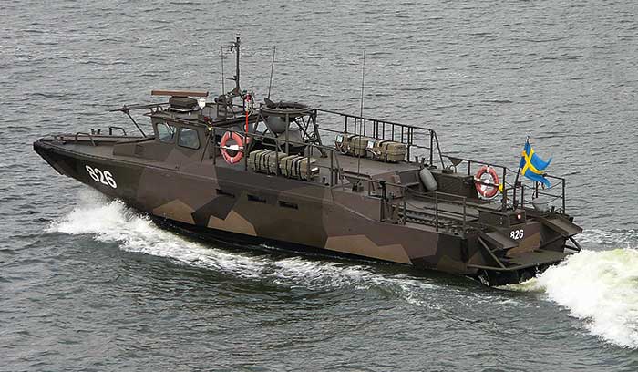
The Swedish Defence Materiel Administration (FMV) signed a contract with navigation company iXblue for up to 172 FOG-based Quadrans gyrocompasses. The Quadrans navigation systems will be delivered over four years and will equip the Swedish Navy’s fleet of high speed crafts, mainly combat boats CB90.
“The FMV was seeking new maintenance-free and high-performance gyrocompasses for the retrofit of their fleet of high speed crafts,” said David Cunningham, commercial director at iXblue. “The CB90 vessels are indeed very fast boats and need the most reliable and accurate heading and attitude data to navigate safely. With our Marins Series Inertial Navigation Systems being already in service on the Gotland-class submarines and Koster Class MCMV’s, and our Quadrans gyrocompasses equipping other surface boats in the Swedish Navy fleet, the FMV was familiar with the high-performance delivered by our systems and knew the Quadrans met the specific requirements needed for the CB90.”
The Quadrans gyrocompasses are build around iXblue’s Fiber-Optic Gyroscope technology. According to the company, the gyrocompasses provide highly accurate heading and attitude data and are perfectly suited for high performance at high speeds and in challenging environments such as GNSS-denied settings.
In addition, the Quadrans Gyrocompasses are compact, lightweight and with low power consumption. They’re easy to install on small-sized crafts, while their open architecture guarantees seamless interfacing with all major GNSS systems and third-party navigation software, iXblue added.
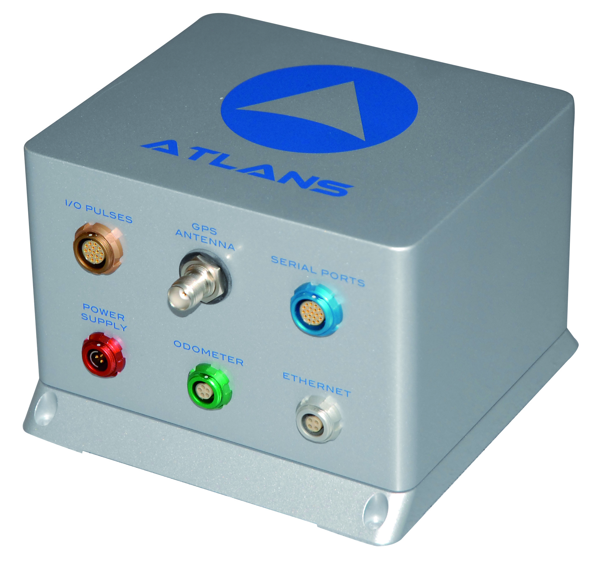
Oceanographic & Geophysical Instruments (OGI) has selected iXblue’s Atlans INS to provide robust and uninterrupted data georeferencing to its newly unveiled mobile-mapping lidar solution dedicated to road assessment surveys.
A fully integrated mobile mapping solution, this new vehicle-based system integrates advanced systems to provide highly detailed georeferenced survey data to transportation departments throughout the United States.
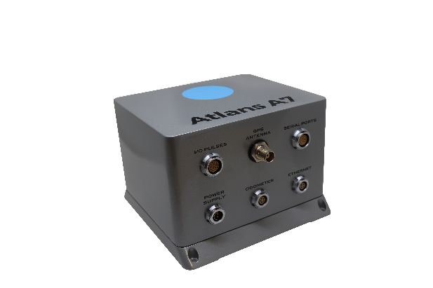
“Highly accurate and reliable georeferencing of the collected data being crucial for road assessment operations, we were seeking a compact and robust navigation solution for our mobile scanner project,” said Darren Moss, program manager at OGI. “We tested other inertial navigation systems (INS) during mobile surveys in New York City and Boston with poor results, as those INS units relied mainly on GPS signals. Maintaining good GPS signals in the urban canyons of large cities proved to be impossible. This deeply impacted the georeferencing of the acquired lidar data, leading to highly inefficient operations. This is the reason we turned to iXblue’s Atlans A7 INS.”
Based on fiber-optic gyroscope (FOG) technology, the Atlans A7 north-seeking INS offers highly accurate and robust data georeferencing. Resistant to GPS outages, it enables continuous acquisition operations within environments lacking continuous GPS signals. The Atlans A7 is a valuable system for high-accuracy data acquisition without interruption.
“Working with iXblue in other markets, we were familiar with the high-quality instrumentation they are known for. We were confident their FOG-based INS systems would perform even during GPS outages,” Darren said. “By choosing the Atlans A7, we are assured to get robust and uninterrupted georeferenced data in urban environments, tunnels, forests, and mountainous areas, which is crucial for our customer’s operations. With this INS, iXblue brings high-end FOG performance to the mobile-mapping industry at a very affordable price.”
“The Atlans A7 integrates very well within our new mobile lidar solution and, combined with Teledyne Optech Polaris high-resolution lidar scanner and QPS Qinsy display and acquisition software, it brings high-accuracy and efficiency to the core of our Mobile lidar solution,” Darren said.
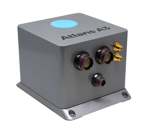
iXBlue has launched a new range of FOG-based inertial navigation system (INS) dedicated to land and air mobile mapping applications, the Atlans Series. iXBlue is high-tech company specializing in the design and manufacturing of advanced navigation and georeferencing solutions.
Based on iXBlue’s fiber-optic gyroscope (FOG) technology, the Atlans Series is a scalable range of north-seeking and north-keeping inertial navigation systems. They provide FOG performance to the full spectrum of land and air mobile-mapping applications and offer highly accurate positioning (up to 0.01 meter) in all conditions, including within GNSS-denied environments such as urban canyons, mountainous or forests areas.
“Our existing high-grade Atlans A7 INS had already been adopted as the preferred georeferencing solution by leading U.S. companies operating in the pavement condition survey industry,” explained Marine Slingue, vice president, iXBlue. “Having identified the high potential of our technology for other land and mobile mapping applications, we decided to develop a complete range of scalable INS that each meet the specific requirements of every applications. With our new Atlans Series INS, we are now bringing the unrivaled georeferencing accuracy performance offered by the FOG technology to all land and air mapping applications, enabling robust and uninterrupted data-acquisition operations.”
Quick and simple to install on all platforms, the new Atlans Series INS offers efficient “set-and-forget” operations for a wide range of land and air applications including asset inventory, pavement condition survey, vehicle automation, HD mapping, automotive testing, ground-truth, airborne surveys (UAVs, planes, helicopters), as well as precision pointing.
iXBlue, a navigation and positioning company, is providing 70 Marins M7 to equip 35 Royal Navy major surface ships and submarines as part of the Navigation Compass Programme.
The decisions to equip both the Queen Elizabeth-Class Aircraft Carriers and the fourth Astute-Class nuclear-power submarine with iXBlue’s Marins inertial navigation system (INS) were the first steps made by the UK Ministry of Defense toward the adoption of iXBlue fiber-optic gyroscope technology.
The ministry awarded a five-year contract awarded to Lockheed Martin UK, iXBlue’s strategic partner, for iXBlue’s inertial technology.
The 70 Marins M7 INS will replace the obsolete gyro systems on board the Royal Navy ships which include Type 23 Frigates, Hunt and Sandown Class mine countermeasure vessels and submarines. They will be integrated by Lockheed Martin UK within the compass system installed on board.
“We conducted a detailed assessment of all available possible partners along with their proposed technologies,” said Robert Kramer, vice president of Lockheed Martin UK – Integrated Systems. “By precisely understanding the Royal Navy expectations and assessing their views on the industry leading suppliers, it clearly appeared that iXBlue’s solutions best fitted the needs in terms of performance, capability and cost.”
The Marins family of military-grade FOG INS (M3, M5 and M7 models) are the latest additions to iXBlue range of naval products. They offer performances and reliability that meet the requirements of the demanding navies. Marins M7 model offers a drift of less than 1 nautical mile in 72 hours of surface GNSS-denied or submarine-dived navigation.
“We are very grateful to the Royal Navy for such a decision that demonstrates through a fair and open competition iXBlue’s INS excellence in terms of performance, reliability, lifecycle costs and versatility. This success relies on iXBlue core values: innovation, excellence and a strong commitment to the user,” said Olivier Cervantes, iXBlue vice president for sales and marketing.
Such a milestone contract opens up bright prospects for iXBlue in the field of military inertial solutions, Cervantes said.
iXBlue — a subsea navigation, positioning and imaging systems company — is offering two new positioning sensors.
Fifth-generation Octans
iXBlue is offering its customers the opportunity to upgrade their fourth-generation Octans positioning reference system to the fifth-generation system. The fourth-generation Octans was manufactured beginning in January 2014.
Built on iXBlue’s high-performance fiber-optic gyroscope technology, the Octans is an all-in-one gyro compass and motion sensor (attitude and heading reference system) with features such as IMO/IMO-HSC certification. The upgraded system provides extremely accurate real-time output for roll, pitch, heading and heave, as well as acceleration and rate of turns under challenging GNSS-denied environment.
Heading measurement accuracy has been doubled over the fourth-generation Octans: with still 0.1° Seclat in stand-alone, the system can now provide 0.05° Seclat with GNSS.
Moreover, the fifth-generation Octans now offers the ability to align on transit and the extended capability to deliver, in real time, accurate heave for swells up to 30 seconds.
The offer from iXBlue includes both the upgrade and calibration, backed by a five-year warranty.
Rovins Nano for remotely operated underwater vehicles (ROVs)
iXBlue has also launched a new inertial navigation system for the offshore industry, the Rovins Nano.
Based on iXBlue’s fiber-optic gyroscope technology, the Rovins Nano has been designed for ROV pilots performing maintenance and construction operations. It offers the stability and accuracy of the inertial position, outputting true north, roll, pitch and rotation rates.
“Rovins Nano is able to directly transmit the ROV’s position with extreme accuracy thanks to its integrated INS algorithm capable of collecting acoustic data,” said Paul Wysocki, iXBlue Rovins Nano product manager. “This is now possible regardless of the depth at which it is located: it is therefore not just an evolution, but rather a revolution for the middle water station keeping.”
Where the Doppler Velocity Log (DVL) has limitations, especially when operating in middle water, Rovins Nano is now there to guarantee optimal navigation safety.
“In the future, it will no longer be necessary to use a DVL,” Wysocki said. “Even in ‘sparse array’ LBL fields, with the presence of only one or two beacons, the combination between Rovins Nano and our Ramses acoustic system enables us to reach extremely accurate positioning data.”
A science ROV being retrieved by an oceanographic research vessel.
iXBlue provides more flexibility to its customers: by avoiding the use of DVL, operators reduce their operational and associated calibration costs.
Besides its high level of performance, Rovins Nano adapts itself to the user: the configuration, installation and product’s use have been considerably facilitated, while incorporating a system as complex as the inertial navigation system (INS). The ultimate goal is for the pilot to forget the existence of the product when maneuvering. Moreover, thanks to its compactness, lightness and open architecture with all third-party sensors, Rovins Nano is easy to integrate.
The French high technology company iXBlue is now offering an expanded range of subsea navigation systems, from ROV navigation to survey applications.
iXBlue, a provider of navigation, positioning, and mapping solutions, has launched its new ATLANS-C position and orientation system, developed in close cooperation with Septentrio Satellite Navigation. The system is designed to provide continuous and accurate positioning in urban environments, where GNSS signals are obscured, intermittent, or possibly distorted by reflective surfaces.
ATLANS-C benefits from the optimized integration of iXBlue’s fiber-optic gyroscope (FOG) based inertial navigation system (INS) and Septentrio’s multi-constellation GNSS receiver technologies. Experts from iXBlue and Septentrio worked closely to develop a “smart” coupling method that combines the advantages of the two companies’ technologies. The result is an easy-to-use, easy-to-integrate, and highly reliable INS-GNSS mobile mapping solution, the companies said.
“The ATLANS-C development was a real team effort,” said Jan Van Hees, head of sales and business development at Septentrio. “Technical trials with leading customers have already demonstrated superior accuracy, continuity, and reliability of positioning and attitude data, even in the most challenging urban environment.”
“The new system’s robustness, compact size, and improved urban-area performance uniquely address more complex mobile mapping market requirements. The ease of use, quick integration, and zero maintenance features are excellent values recognized by original equipment manufacturers (OEM) or mobile mapping system integrators,” explained Xavier Montazel, head of iXBlue inertial products division. “One of ATLANS-C’s many other advantages is its versatility, allowing the same equipment to be used for land and air applications. Configuration of the system is achieved through the use of iXBlue’s innovative web interface, utilized across the complete range of products.”
ATLANS-C has no ITAR components inside, allowing fast and easy global export. Customers will benefit from the industry exclusive five-year warranty and a 24/7 support line. ATLANS-C is available today with a six-week lead time.