Tag: J. David Grossman

  • GPSIA supports bipartisan RETAIN Act

    GPSIA supports bipartisan RETAIN Act

    J. David Grossman, executive director, GPSIA
    J. David Grossman, executive director, GPSIA

    Guided by the leadership of the U.S. Air Force, and now the Space Force, for four decades GPS has supported all aspects of military operations, from precision guided munitions to search and rescue missions. GPS, however, is also ingrained in our economy, enabling a wide range of civil and consumer applications, including aviation, precision agriculture, construction, banking and public safety.

    It’s easy to take GPS for granted, because we use it every day and it works so well. But what if someone interfered with the reliability and accuracy of GPS on which we depend? A 2019 study sponsored by the National Institute of Standards and Technology (NIST) estimated a $1 billion-a-day impact to our economy if GPS were lost.

    Regrettably, the Federal Communications Commission (FCC) rolled the dice on this scenario in 2020, when it approved an application from Ligado Networks, a satellite communications company, to repurpose satellite spectrum in the L-band for high-power terrestrial use.*

    Ignoring the warnings of a broad coalition of stakeholders, including U.S. federal agencies, congressional leaders and businesses, the FCC moved to open the traditionally “quiet neighborhood” used by satellite-based navigation services like GPS to ground-based signals that are billions of times more powerful.

    The FCC itself was clear on the risks when it issued the order, and so it’s no surprise they explicitly required Ligado to “repair or replace as needed any U.S. government GPS devices that experience harmful interference from Ligado’s operations.” At the time, however, a key constituency was excluded from these protections: the millions of U.S. consumers and businesses who rely on accurate, reliable GPS signals.

    In fact, 99% of the more than 900 million GPS devices found in the United States are used by the private sector, consumers, as well as state and local governments. Under the FCC’s order, first responders, pilots, municipal governments, farmers and countless other GPS users have been left on the hook for costs associated with Ligado’s disruptions.

    On June 22, a bipartisan group of senators, led by Sen. Jim Inhofe (R-OK), took a critical step toward addressing this inequality by introducing the Recognizing and Ensuring Taxpayer Access to Infrastructure Necessary for GPS and Satellite Communications Act (RETAIN Act). A bipartisan House companion bill was subsequently introduced on July 22. This carefully balanced proposal ensures that Ligado, as the license holder and source of interference, is the one responsible for paying the costs to upgrade or replace affected GPS receivers used by consumers and businesses.

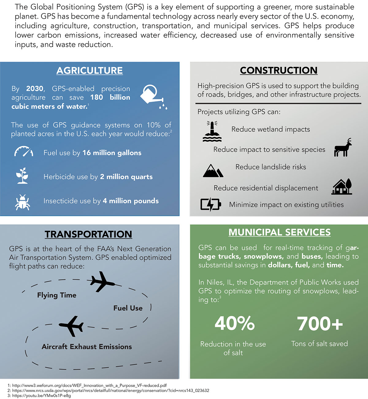
    Across the country, GPS is woven into the fabric of the economy and people’s everyday lives. More than 100 million vehicles are equipped with a GPS receiver, and trains and aircraft use GPS to move people and goods. Our farms depend on GPS to increase crop yields and reduce waste. Similarly, with accurate and reliable GPS,

    America’s bridges, and roads are being built more accurately, improving safety, and reducing construction times.
    The RETAIN Act also protects municipal fire crews that depend on GPS for improved situational awareness and to speed response times to people in danger. In the critical moments between a 911 call and the arrival of firefighters, seconds matter. An unexpected loss of GPS could therefore be catastrophic. This is why GPSIA and more than 100 industry organizations and companies are supporting the RETAIN Act.

    The RETAIN Act also considers the thousands of businesses that are showcasing their grit and ingenuity to bounce back from the COVID pandemic. Many of these companies are implementing GPS-enabled solutions, including app-based delivery and contact-tracing tools to increase efficiency and protect the safety of their employees.

    The GPS Innovation Alliance, an organization committed to furthering GPS innovation, creativity and entrepreneurship, is grateful to these leaders in Congress who are standing up in support of GPS users.


    • Consistent with the terms of their litigation settlements with Ligado, Garmin International Inc. and Deere & Company do not affirmatively endorse or oppose the deployment of Ligado’s proposed mobile communications network. To the extent this op-ed discusses Ligado’s deployment of its proposed 5G mobile communications network (or any interference therefrom), GPSIA is not authorized, and does not purport, to speak for Garmin and Deere.
  • GPS: The environment’s unsung hero

    GPS: The environment’s unsung hero

    J. David Grossman
    J. David Grossman

    Can GPS support a greener, more sustainable planet? The answer is an emphatic “yes,” and it is already doing so today.

    GPS has become a fundamental technology across nearly every sector of the U.S. economy, including agriculture, transportation, construction and municipal services. In each of these industries, the use of GPS has produced substantial environmental benefits, such as lowered carbon emissions, increased water efficiency, decreased use of environmentally sensitive inputs, and reduced waste.

    Agriculture

    Let’s take a closer look at how GPS is protecting our nation’s critical environmental resources. We begin with agriculture where it is estimated that the absence of GPS during peak planting season could result in an economic loss of more than $15 billion, according to a National Institute of Standards and Technology report.
    During the past two decades, GPS has transformed American farming, enabling increased crop yields, cost efficiencies, and environmental sustainability through the precise application of seed, water, fertilizers and pesticides and the efficient use of fuel. In sum, precision agriculture lets farmers do more with less wasted seed, less fertilizer, less fuel, less pesticide, and more crop yield.

    GPS Innovation Alliance (GPSIA) founding member Deere & Company reports that precision agriculture technologies can have a huge impact on resource efficiency and sustainability. By 2030, GPS-enabled precision agriculture implemented globally could save 180 billion cubic meters of water, says the World Economic Forum.
    Similarly, according to the U.S. Department of Agriculture’s Natural Resources Conservation Service (NRCS), if “[GPS] guidance systems were used on 10 percent of the planted acres in the United States, fuel use would be cut by 16 million gallons, herbicide use by two million quarts, and insecticide use by four million pounds per year.” For a single Midwest row crop farmer, with 6,500 acres using precision agriculture techniques, Deere & Company estimates that more than 1,600 gallons of fuel could be saved, and more than 400,000 kg CO2 equivalent emissions could be avoided, over the course of a production cycle — the equivalent of nearly a million (992,000) passenger car miles driven per year.

    Infographic: GPS Innovation Alliance
    Infographic: GPS Innovation Alliance

    Construction

    Construction is another industry that has been revolutionized by GPS. Today, high-precision GPS is used to support the building of roads, bridges and other significant infrastructure projects. In 2019, testimony before the U.S. House Small Business Committee, an executive of GPSIA founding member Trimble described several examples of how digital construction technologies, including GPS, can more efficiently plan and execute complex construction projects.

    In one such example from Southern California, the improvements “reduced the wetland impact by 58 acres; reduced the impact to sensitive species; reduced landslide risk; reduced residential displacement; and minimized the impact on existing utilities (resulting in few utility relocations to undisturbed areas).”
    GPS receivers are also embedded in many bulldozers, excavators and graders, resulting in reduced waste and lower fuel consumption. They can reduce greenhouse gas emissions, with an estimate from Trimble suggesting that the use of machine control technologies can cut more than one billion pounds of CO2 usage per year.

    NextGen Air

    GPS is also at the heart of the Next Generation Air Transportation System, or NextGen, of the Federal Aviation Administration (FAA). Capt. Sully Sullenberger, during a 2020 GPSIA-sponsored event, described air traffic control modernization as depending “massively on the ubiquity and reliability of GPS.”

    Along with the safety benefits of knowing the precise location of an aircraft, GPS enables optimized flight paths that the FAA says can reduce “flying time, fuel use, and aircraft exhaust emissions.” These efficiencies have already resulted in $1.2 billion in fuel savings, according to the FAA.

    During a 2010 test flight over Puget Sound, Washington, Alaska Airlines found that the use of GPS-aided flight procedures reduced emissions by 35% compared to a conventional landing. Other airlines have also quantified these benefits, finding substantial savings in fuel consumption simply by cutting a single minute from each flight.

    Weather and Disaster Forecasts

    No one can argue the fact that weather events like hurricanes, floods and droughts have a huge impact on the environment and public safety. According to the National Oceanographic and Atmospheric Administration (NOAA), in 2020 such events cost $95 billion in damages. You may not realize, however, that NOAA uses GPS signals to support three-dimensional meteorology, space weather and geophysical applications throughout the United States.

    Even NOAA’s Geostationary Operational Environmental Satellites (GOES) use GPS signals to enhance their ability to provide the data we all receive in each morning’s TV weather forecast, improving weather predictions and our own storm situational awareness. GPSIA member Lockheed Martin manufactures both the GOES-R series of weather satellites and the U.S. Space Force’s more powerful, next-generation GPS III satellites that are now being launched to modernize the GPS constellation.

    Municipalities

    Lastly, we examine the environmental benefits for municipalities that use GPS for key government services, including the real-time tracking of garbage trucks, snowplows and buses. Throughout the country, towns and cities have seen substantial savings in dollars, fuel and time from implementing GPS-enabled technologies.
    In Niles, Illinois, for example, the Department of Public Works partnered with GPSIA founding member Garmin to optimize the routing of snowplows. Using GPS technology, drivers reduced the use of salt by as much as 40%, resulting in more than 700 tons saved. In 2020, in recognition of its innovative use of GPS, the department received the Management Innovation Award from the American Public Works Association. Similarly, GPSIA member CalAmp found that GPS use for vehicle tracking can result in fuel savings of $90 per vehicle per month.

    Ensuring GPS

    Ensuring these environmental benefits can continue to be realized requires that the spectrum used by GPS be protected from harmful interference. It will also depend on continued funding by Congress to modernize the GPS constellation and ground control. Additionally, as Congress considers a major infrastructure bill, including funding for states and localities, we would encourage projects to make use of GPS and other innovative technologies that can drive down costs, reduce carbon emissions, and eliminate waste — including advanced digital-construction management systems that use GPS data to reduce project costs and speed project delivery.
    GPS has changed our everyday lives for the better, and as our dependence on this technology continues to grow, so will its impact on environmental sustainability efforts.


    J. David Grossman is Executive Director of the GPS Innovation Alliance.

  • GPS coalition asks White House to fix Ligado/5G chaos

    GPS coalition asks White House to fix Ligado/5G chaos

    GPSIA logoThe GPS Innovation Alliance (GPSIA) sent a letter on Feb. 16 to the White House National Economic Council, asking it solve the issues with Ligado interfering with GPS spectrum.

    “Strong and unified leadership by the U.S. government is needed to preserve and advance GPS — leadership that recognizes the inherently unique functional and technical attributes of GPS,” wrote J. David Grossman, GPSIA executive director, in the letter.


    Panel on risks to sat services

    GPSIA’s J. David Grossman will be speaking Feb. 17 at 2 p.m. ET, in a panel discussion entitled “Satellite-Based Services at Risk?” Other speakers include former FCC Commissioner Robert McDowell; Capt. Steve Jangelis, representing the Air Line Pilots Association (ALPA); and Susan Avery, former president of the Woods Hole Oceanographic Institution. Register here.


    The coalition, which counts Garmin, Apple and John Deere among its members, was ensnared in the dispute between Trump executive branch agencies and the Federal Communications Commission (FCC) over whether the commission’s Ligado approval decision in 2020 would affect GPS.

    In the letter to NEC Director Brian Deese, the group argues that these squabbles “are not unique to GPS” and “reflect a continued pattern by which shared decision-making is replaced by the FCC acting with exclusive authority as the final arbiter.”

    GPSIA recommends that the council

    • update a memorandum of understanding between the FCC and Commerce Department to help ease decision-making;
    • install a detailee from federal agencies managing GPS in the FCC’s engineering office; and
    • have each FCC commissioner add a technical adviser to its staff.

    The letter concludes, “GPSIA and its members stand ready to be a resource to the NEC and others in the Administration seeking to more efficiently allocate spectrum, while protecting critical incumbent systems and services.”

  • L3Harris joins advocacy group GPS Innovation Alliance

    L3Harris joins advocacy group GPS Innovation Alliance

    Logo: GPS Innovation AllianceAlliance membership has tripled in past 13 months as the organization grows advocacy for ever-increasing importance of GPS technologies to the global economy.

    The GPS Innovation Alliance (GPSIA) has announced L3Harris Technologies as the newest member of the organization.

    L3Harris Technologies, a global aerospace and defense technology innovator, joins a core of companies committed to furthering GPS innovation, creativity and entrepreneurship.

    As the newest member, L3Harris Technologies will work with GPSIA to promote the modernization of GPS and its impact on military operations, economic growth and technological innovation.

    J. David Grossman
    J. David Grossman

    “With the addition of L3Harris, the alliance welcomes a company recognized globally for developing and advancing innovative uses of GPS to protect our nation’s national security,” said GPSIA Executive Director J. David Grossman. “Having now tripled membership over the last 13 months, GPSIA is in a position of strength to continue leading advocacy for the promotion, protection and enhancement of GPS, both in the U.S. and around the globe. L3Harris Technologies is an integral part of the deployment of next-generation GPS III satellites and we look forward to working with them to ensure this technology remains the gold standard for delivering positioning, navigation and timing functions to our military as well as a wide range of other sectors, including transportation, agriculture, electricity and finance.”

    L3Harris Technologies has played an integral part in the story of GPS, as it has provided navigation technology for every U.S. GPS satellite ever launched. L3Harris Technologies is developing 10 GPS III satellite navigation payloads for the U.S. Air Force’s GPS III satellite program, four of which are already operational.

    The company will also provide navigation payloads with fully digital Mission Data Units (MDU) for the U.S. Air Force’s GPS III Follow-On, known as GPS IIIF, satellites. The MDU will provide even more powerful signals and ensure flawless atomic clock operations.

    “GPS technology is an important part of the modern world and critical for the warfighter,” said Joseph Rolli, L3Harris Technologies Positioning, Navigation and Timing.

    “With more than 40 years of experience developing GPS technologies, L3Harris aims to continue to improve the system with a more powerful, reliable, and flexible signal. We look forward to joining GPSIA and its other industry leading members as we advocate for continued support of this incredible system,” Rolli said.

  • First Fix: New year, new opportunities for GNSS industry

    First Fix: New year, new opportunities for GNSS industry

    Headshot: J. David Grossman
    J. David Grossman

    By J. David Grossman
    Executive Director
    GPS Innovation Alliance

    As we embark on a new year, 2021 ushers in a new administration and the start of the 117th Congress. With these changes comes a litany of opportunities, as well as challenges, for the nearly four-decade-old GPS industry.

    Next month, the GPS Innovation Alliance (GPSIA) will mark its eighth anniversary as the voice of the GPS industry, educating policymakers and regulators about the GPS success story of innovation, economic growth and job creation. It is a uniquely American story made possible because of bipartisan support for protecting the spectrum used by GPS and maintaining funding to enable the modernization of the GPS constellation, ground control and military ground user equipment.

    Congressional Support. This commitment was evident in the last Congress through broad support from both parties for two Congressional resolutions, H.Res.219 and S.Res.216, that affirmed the importance of continuous availability, accuracy, efficiency, robustness, reliability and resiliency of the GPS constellation.

    Innovation and modernization of the GPS constellation are well underway. Last year, under the emerging leadership of the U.S. Space Force, two new Lockheed Martin-built GPS III satellites were launched into space. This new generation of GPS satellites offers three times greater accuracy, up to eight times improved anti-jamming capability for military users, and the addition of the L1C signal to enable interoperability with other navigation systems, such as Europe’s Galileo.

    GPS modernization also has led to the introduction of M-code, an advanced, new signal designed to improve anti-jamming and anti-spoofing, as well as to increase secure access to military GPS signals for U.S. and allied armed forces. In GPS-denied environments, M-code reduces the jamming radius, giving military planners and targeteers options to minimize or avoid collateral strike damage.

    With at least two additional GPS III satellites set to launch this year and a new ground control segment known as the Next Generation Operational Control System (OCX), the continued success of the GPS program remains bright.

    Ligado Still Looms

    As GPSIA continues to urge Congress to allocate the funding needed to support the modernization of GPS, we also are fighting to ensure uninterrupted operation of the estimated 900 million GPS devices in the United States ranging from precision agriculture to consumer gadgets.

    Last year, we were deeply disappointed by the Federal Communications Commission’s (FCC) decision approving the applications of Ligado Networks, despite the well-documented objections of the expert agencies charged with preserving the integrity of GPS, specifically, on the critical issue of what constitutes harmful interference to users of GNSS.

    Regrettably, the FCC chose to ignore the established “1-dB Standard,” which has a long history of protecting GPS operations from harmful interference in both international and domestic regulatory proceedings.


    “All Americans benefit from a competitive 5G landscape.”


    At the same time, Ligado and its supporters continue to argue that their proposal is the fastest way to bring 5G to all Americans. In actuality, millions of Americans already have access to 5G services and, thanks to the efforts of the FCC, hundreds of megahertz of 5G spectrum in low-, mid- and high-band frequencies have been or will soon be made available for commercial use. GPSIA believes all Americans benefit from a competitive 5G landscape.

    5G without compromise. However, that goal can be achieved without undermining GPS receivers and devices that are foundational to wireless technology in general, including 5G. We remain hopeful that a new administration and congress will commit to protecting GPS receivers from harmful interference using the appropriate standard for determining such interference to ensure that the more than $1 billion per day in U.S. economic impact created by GPS continues to flourish.

    2020 also brought the issue of GPS resiliency into the national forefront. In February, the president signed an Executive Order aimed at fostering greater resiliency for positioning, navigation and timing (PNT)-based systems, including GPS.

    GPSIA supported this order and outlined in subsequent regulatory filings why GPS remains the gold standard for delivering PNT functions to our military as well as a wide range of other sectors, including transportation, agriculture, electricity and finance.

    Complementing GPS. As the federal government considers alternative PNT solutions, it is critical that they be complementary to GPS, able to easily integrate into current or future devices, and based on a recognition that each PNT application has unique requirements driven by its intended function, environment and design factors. In sum, there is no one-size-fits-all solution.

    Protecting Consumer Privacy. Looking ahead, GPSIA expects 2021 will bring a robust discussion around consumer privacy protections. While GPS satellite broadcasts are one-directional and cannot track a user’s location, we recognize that GPS is one of many data points that can contribute to application-specific location tracking. As such, GPSIA would urge Congress to ensure that geolocation data is appropriately addressed as part of any U.S. federal privacy legislation. In doing so, we believe protections for precise geolocation information will empower consumer choice, enhance transparency, and strengthen security.

    On the surface, infrastructure modernization, protecting GPS spectrum, PNT resiliency, and consumer privacy may seem like distinctly different issues. What they have in common, though, is an ability to garner bipartisan support, deliver substantial consumer benefits, and strengthen our nation’s economy. GPSIA stands ready as a resource and looks forward to working with the Biden-Harris Administration and leaders in the House and Senate to promote, protect and enhance GPS.

  • Maintaining the 1-dB standard

    Maintaining the 1-dB standard

    How do we ensure that GPS is protected from harmful interference?

    By J. David Grossman, guest columnist

    J. David Grossman
    J. David Grossman

    Debates in Washington over harmful interference and the coexistence of divergent services are raging. Nowhere are the differences more apparent than when comparing radio navigation services such as GPS to radio communications systems used in wireless communications networks.

    How do we ensure that a satellite-based radionavigation service like GPS, which by design operates below the ambient noise floor, is protected from harmful interference? The International Telecommunications Union’s (ITU) definition of harmful interference provides a starting point, by defining harmful interference as a level that “endangers the functioning of a radionavigation service.”

    With this foundational definition, the internationally established criterion of a 1-decibel (dB) increase in the noise floor, otherwise known as the 1-dB standard, provides the answer, offering a readily identifiable, objective and predictable metric.

    The 1-dB standard uses a 1-dB increase in the noise floor as the distinction between the onset of interference that can be detected by a GPS receiver and harmful interference. (This can be reliably measured by a 1-dB decrease in the carrier-to-noise ratio, C/N0, reported by the receiver). Thus, the 1-dB standard provides a definitive way to protect GPS receivers from harmful interference. Adherence to this standard helps ensure that systems operating in an adjacent spectrum band do not interfere with GPS.

    Why use the 1-dB standard instead of other metrics? The 1-dB standard is based upon well-understood GNSS engineering considerations and is associated with quantifiable changes in the overall noise to which GNSS receivers are subject, with equally well-understood effects on receiver operation. (The 1-dB standard enables system designers and spectrum regulators to carefully assess interference from various sources and analyze their net effect on GNSS receivers).

    It also has been adopted internationally and has a long and well-established proven history of protecting GPS operations from harmful interference in both international and domestic regulatory proceedings.

    So-called “alternatives” to 1 dB, which may be appropriate in the context of radio communications systems, fail to recognize that the accuracy, integrity and reception (availability) of GPS signals used by a receiver can be degraded by interfering noise in ways not immediately apparent to an end user. This means that the effects of degraded service of GPS signals can still be detrimental well before the user loses position accuracy or experiences complete loss of position.

    Additionally, C/N0 is computed at the entry point of a GPS receiver, such that a 1-dB decrease serves as an early warning of interference potentially becoming harmful. Other metrics, computed further downstream, may be indicative of harmful interference already occurring.

    GPS has become a fundamental part of our lives and is an integral engine of the U.S. economy, creating new jobs, and unlocking innovation. Maintaining the 1-dB standard ensures that the GPS success story and American innovation will continue for decades to come.


    J. David Grossman is executive director of the GPS Innovation Alliance.

  • Collins Aerospace joins GPS Innovation Alliance

    Collins Aerospace joins GPS Innovation Alliance

    GPS Innovation AllianceCollins Aerospace has joined the GPS Innovation Alliance (GPSIA).

    Collins Aerospace is one of the world’s largest suppliers of aerospace and defense products, and joins founding-member companies John Deere, Garmin and Trimble as well as 11 national organizations who make up GPSIA’s affiliates program.

    Collins will further bolster the Alliance’s goal of enhancing GPS innovation, creativity and entrepreneurship.

    “We are excited to welcome Collins Aerospace as the newest member of the GPS Innovation Alliance,” said GPSIA Executive Director J. David Grossman. “As one of the leading aerospace companies in the world, Collins has a long and deep history with GPS technology, beginning with the first GPS signal ever received from the roof of their facilities in Cedar Rapids, Iowa. We look forward to working with Collins Aerospace as the newest member of GPSIA and are confident that they will be a valuable addition in our efforts to heighten awareness of the economic importance and societal benefits of GPS.”

    “GPS technology is vital to Collins Aerospace, enabling us to achieve innovative solutions for the aerospace and defense industries,” said Frank Zane, associate director of Business Development, Position, Navigation, Timing (PNT), Collins Aerospace. “We are thrilled to join the GPS Innovation Alliance in their long-standing efforts to ensure the continuous availability, accuracy, reliability, and resiliency of the GPS constellation.”

    ​The GPS Innovation Alliance was founded by Deere & Company, Garmin International, Inc. and Trimble Inc. The alliance recognizes the ever-increasing importance of  GPS  and other GNSS technologies to the global economy and infrastructure and is firmly committed to furthering GPS innovation, creativity and entrepreneurship.

  • Freedom to innovate promotes GPS resiliency

    Photo: Tomáš Hustoles/ Unsplash
    Photo: Tomáš Hustoles/Unsplash

    Ensuring the freedom to continue innovating is vital to our global economy, job creation and ultimately to empowering the next generation of GPS-enabled applications.

    By J. David Grossman, Executive Director,
    GPS Innovation Alliance

    GPS — it’s a household name and has come to benefit so many aspects of our day-to-day lives. Today across the globe, it is estimated that there are more than 3 billion GPS receivers in the marketplace. Included in this total are GPS receivers found in mobile phones, automobiles, airplanes, tractors, boats and high-precision surveying equipment, to name just a few examples. In the past decade alone, GPS applications like these have helped generate more than $1.2 trillion for the U.S. economy and millions of jobs.

    So how did GPS become so ubiquitous? Thanks to the leadership of the United States Air Force, which maintains and operates the GPS constellation, and long-standing U.S. policy, which makes GPS available as a vital public resource, any private sector company can design and build a receiver capable of listening for these GPS signals, without seeking the government’s approval or paying user fees. This freedom to innovate is at the heart of why GPS has been so successful and continues to drive innovation across our economy.

    With the freedom to innovate, GPS receiver manufacturers have developed a range of advanced technologies to address market needs from the simple to the highly complex. These technologies reflect the inherent functional and technical differences between radio communications services and a navigation service like GPS.

    Huge range of technologies. GPS receiver innovations enable a receiver to listen for a GPS signal that is less than a millionth of a billionth of a watt, while simultaneously resisting interference that is 10,000 times greater. Whether the GPS receiver is found in a tiny smartwatch or a 20-ton tractor, what they have in common is the ability to convert a faint radio signal into what we most commonly recognize as our current location displayed as a blue dot. They do this remarkably well.

    Today’s regulatory landscape also correctly recognizes that every GPS-enabled application has unique requirements driven by intended function, environment and design factors. For example, a GPS receiver used for synchronizing financial transactions has different demands from a GPS receiver found in an autonomous vehicle. The former focuses on timing while the latter needs precise positioning to help maintain lane-level guidance.

    Similarly, high-precision surveying equipment capable of delivering centimeter-level accuracy will no doubt have different receiver and antenna requirements than those found in a typical smartphone. The freedom to innovate enables GPS receiver manufacturers to support this market differentiation.

    GPS resiliency. With many of our nation’s key critical infrastructure sectors dependent on GPS, there has been increasing discussion in Washington about the resiliency of GPS. Some have specifically expressed concern that a GPS jamming or spoofing attack could disrupt these key services and have advocated for new requirements on GPS receivers.

    To be clear, GPS jammers and spoofers are illegal devices, designed specifically to interfere with GPS signals, either blocking the signal outright or emitting a fake signal in order to falsify one’s location. In either scenario, this interference occurs within a localized area from a detectable source. So, the reality is that mandates won’t stop a malicious actor intent on illegally interfering with GPS or another wireless technology, but vigorous enforcement of U.S. federal law can.

    It is also important to remember that the GPS satellites are a multi-use U.S. military-civilian asset, supporting the mission of our armed forces, and have therefore been built with the highest levels of security and redundancy. Any attempts to attack the GPS constellation risks impacting not just civil services but the military signal as well.

    Mission-critical applications. When it comes to resiliency, open innovation enables GPS receiver manufacturers to work with mission-critical application providers to develop products designed to meet their specific requirements. Different categories of users can and should define and specify performance and resiliency requirements appropriate for their applications.

    For example, the requirements for a military GPS receiver are much more demanding than those for the receiver in an IoT device that reports its position hourly or daily. A military GPS receiver will, therefore, be significantly more expensive than an IoT receiver. Conversely, those who deploy internet of things (IoT) receivers will require low price points to support ubiquitous applications.

    GPS manufacturers and applications developers have responded to market requirements by providing new and innovative techniques for increasing resilience, including designing receivers capable of receiving signals from multiple GNSS systems. This is the best way to ensure resilience — via application-specific requirements that are driven by customers who are most knowledgeable about their needs, not by general regulations or government fiat.

    Preserving signal access. At the same time, the government does have a responsibility to investigate and take the necessary enforcement action to preserve unhindered reception of GPS signals. Vigorous enforcement of federal law by the Federal Communications Commission (FCC) and other government agencies — which already prohibits the manufacture, importation, marketing, sale and operation of GPS jammers — can keep these illegal devices out of the hands of those seeking to disrupt GPS operations. Such enforcement is critical to protecting our military operations, aviation and other safety-of-life applications.

    Over the past three decades, worldwide adoption of robust, innovative GPS receivers attests to the trust users have placed in GPS as the gold standard for availability, accuracy, reliability and resiliency. Ensuring the freedom to continue innovating is vital to our global economy, job creation and ultimately to empowering the next generation of GPS-enabled applications.

    About the GPS Innovation Alliance

    The GPS Innovation Alliance was founded by Deere & Company, Garmin International Inc. and Trimble Inc. The Alliance recognizes the ever-increasing importance of GPS and other GNSS technologies to the global economy and infrastructure and is firmly committed to furthering GPS innovation, creativity and entrepreneurship. The GPS Innovation Alliance seeks to protect, promote and enhance the use of GPS. For more information, visit www.gpsalliance.org or follow @GPS4Life.


    J. David Grossman serves as executive director of the GPS Innovation Alliance (GPSIA), an organization dedicated to protecting, promoting and enhancing the use of GPS. Prior to joining GPSIA, Grossman spent nearly a decade in public service, including as chief of staff to FCC Commissioner Mignon Clyburn; legislative director and senior advisor for technology policy to Rep. Anna Eshoo of Silicon Valley; and as technology counsel to the U.S. House Small Business Committee under the leadership of Rep. Nydia Velázquez.

    Grossman holds a Master’s Degree in Public Policy from George Mason University and a B.A. in Political Communication from George Washington University’s School of Media and Public Affairs.