Tag: Kongsberg Maritime

  • Seen & Heard: Autonomous sea vessel completes trial, car tracking leads to arrest and more

    Seen & Heard: Autonomous sea vessel completes trial, car tracking leads to arrest and more

    “Seen & Heard” is a monthly feature of GPS World magazine, traveling the world to capture interesting and unusual news stories involving the GNSS/PNT industry.


    Autonomous vessel completes sea trials in Norway

    Photo: Kongsberg Maritime
    Photo: Kongsberg Maritime

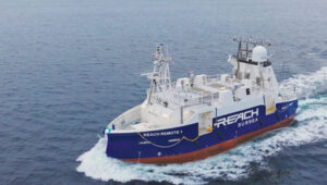
    The Reach Remote 1, an uncrewed surface vessel developed by Reach Subsea in partnership with Kongsberg Maritime and Massterly, has been officially delivered after extensive sea trials overseen by Det Norske Veritas and the Norwegian Maritime Authority. This 24 m vessel is equipped with advanced hull-mounted survey sensors and a Work Class Electric ROV, designed to enhance subsea operations by improving efficiency, safety and environmental sustainability.

    ESA in search of very low-Earth orbit technologies

    Photo: VLEO
    Photo: VLEO

    The European Space Agency (ESA) is seeking innovative space application ideas for very low-Earth orbit (VLEO), an orbital region between 100 km and 450 km. This initiative aims to explore new frontiers in space technology by soliciting creative solutions from researchers and innovators. ESA said VLEO presents several advantages, including reduced launch costs, enhanced Earth observation capabilities and a more harmless radiation environment. ESA is particularly interested in proposals addressing technological challenges specific to this orbital regime, such as atmospheric drag mitigation, advanced propulsion techniques and specialized satellite designs.

    Car tracking leads to successful arrest

    Photo: StarChase
    Photo: StarChase

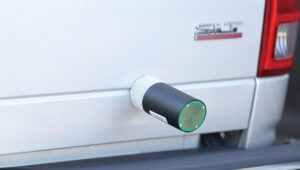
    The Pinole, Calif., Police Department utilized the StarChase GPS-based tracking system to safely apprehend suspects in a stolen vehicle. Instead of engaging in a dangerous high-speed chase, officers launched a GPS-enabled tracker that stuck to the vehicle, offering real-time location tracking. The Pinhole Police Department told The Richmond Standard, “This operation highlights how technology and collaboration keep our community safe — by reducing the dangers of high-speed pursuits while ensuring accountability and swift action.”

    3D mapping of New Zealand coastline

    Photo: nazar_ab / E+ / Getty Images
    Photo: nazar_ab / E+ / Getty Images

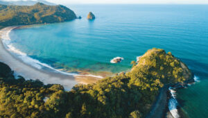
    New Zealand has launched a coastal mapping project to help communities understand and mitigate climate change impacts. Led by Toitū Te Whenua Land Information New Zealand, the initiative will use lidar technology to create detailed 3D maps of up to 40% of the country’s coastline throughout three years. The $30.2 million project involves mapping 4,780 square km of coastal and seafloor terrain using specially equipped planes with high-resolution scanning equipment. Two suppliers, Woolpert NZ and NV5 Geospatial, will conduct the mapping across the North and South Islands, beginning in regions such as the Bay of Plenty and Invercargill.

  • Seabed 2030 and Kongsberg Maritime to map ocean floor

    Seabed 2030 and Kongsberg Maritime to map ocean floor

    Seabed 2030 logoThe Nippon Foundation-GEBCO Seabed 2030 Project and Kongsberg Maritime have entered a memorandum of understanding (MOU) in support of the global initiative to produce the complete map of the ocean floor. Under the terms of the MOU, the two parties will work together to advance understanding of ocean bathymetry. The effort complements the goals of the United Nations Decade of Ocean Science for Sustainable Development.

    Seabed 2030 is a collaborative project between The Nippon Foundation and GEBCO to inspire the complete mapping of the world’s ocean by 2030 and to compile all bathymetric data into the freely available GEBCO Ocean Map. GEBCO is a joint project of the International Hydrographic Organization (IHO) and the Intergovernmental Oceanographic Commission (IOC) and is the only organization with a mandate to map the entire ocean floor.

    Kongsberg Maritime provides solutions for safe, efficient, and sustainable maritime operations. The solutions are suitable for offshore energies, seaborne transportation, hydrography, science, navy, coastal marine, aquaculture, training services and more. Kongsberg Maritime is the largest business area within Kongsberg Gruppen ASA. The Group has an integrated portfolio of solutions for businesses, partners and nations operating from the depths of the sea to outer space and to the digital frontier.

    All data collected and shared with the Seabed 2030 Project is included in the GEBCO global grid, which is free and publicly available.

    The Nippon Foundation-GEBCO Seabed 2030 Project is a collaborative project between The Nippon Foundation and GEBCO. The Seabed 2030 Project, launched at the United Nations Ocean Conference in 2017 by Chairman Sasakawa of The Nippon Foundation, coordinates and oversees the sourcing and compilation of bathymetric data from different parts of the world’s ocean through its five centers into the freely-available GEBCO Grid.

    Kongsberg Maritime is a global marine technology company providing technology solutions for all marine industry sectors including merchant, offshore, cruise, subsea and naval.

  • 2G Robotics laser systems aid in Norwegian mine countermeasures

    The first of four ULS-500 PRO laser scanning systems from 2G Robotics has been shipped to Kongsberg Maritime for integration into the Norwegian Defence Materiel Agency’s (NDMA) newly purchased Hugin autonomous underwater vehicles (AUVs).

    The acquisition signifies the Royal Norwegian Navy’s transition to autonomous systems for mine countermeasures. During operations, Hugin AUVs will be used to complete surveys of subsea environments focused specifically on locating and identifying mines.

    The Hugin systems enable users to conduct fast and efficient operations with zero surface visibility while additionally improving safety conditions by allowing personnel to remain outside the minefield. In peacetime, the AUVs contribute to hydrographic operations.

    The ULS-500 PRO dynamic underwater laser scanner system will contribute to the detection, classification and assessment of mines. 2G’s system acquires data in real time and provides users with 3D models of targets and environments accurate to the sub-centimeter.

    The complete laser scanning system also includes the 2G Observer, an ultra-sensitive stills camera able to capture images at 12 fps, and the 2G Nova, an LED panel designed specifically for AUV integration providing almost 1,000,000 lumens.