The commercially available L5-only GNSS solution includes machine-learning algorithms to leverage increased L5 signal-ranging precision in challenging signal conditions.
OneNav has announced performance results from field testing its latest pureL5 customer evaluation system (CES) software in both open-sky and challenging signal environments.
The patent-pending oneNav GNSS system, including a custom array processor and a library of machine-learning algorithms, demonstrated consistent sub-meter accuracy and rapid time-to-first-fix (<2 sec) in open-sky testing.
In very challenging urban and deep urban canyon environments, the pureL5 CES field-test equipment outperformed the commercial precision L1 GNSS unit against which it was compared, demonstrating tracking of satellite signals as weak as –160 dBm.
The oneNav system was able to acquire directly and track L5 signals in all environments with no L1 receiver present, greatly simplifying the RF front end and antenna subsystem and making the pureL5 solution suitable for space- and power-constrained mobile and internet of things (IoT) devices requiring reliable high performance.
Results of a representative urban drive test route are shown below (the map describes the route driven). During this test, the CES and the commercial precision L1 receiver were both connected to a common antenna, fixes were taken once/second, and the results were compared to a common ground truth position. On average, the oneNav system demonstrated a 55% improvement in accuracy over the precision.
Image: oneNav
OneNav’s family of algorithms improves pureL5 system performance by predicting whether the received signal is line of sight (LOS) and correcting non-line-of-sight (NLOS) signals to increase the number of measurements available for accurate positioning.
The pureL5 algorithms characterize signal and multipath environments. Accordingly, algorithms developed in one deep urban area can be used to mitigate multipath in areas geographically different, but that present similar multipath signatures. This obviates the need for field-test teams to collect data in thousands of urban areas around the globe.
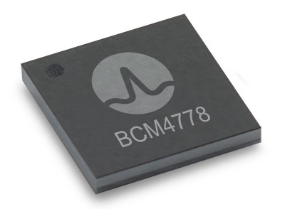
The BCM4778’s third-generation dual-frequency GNSS receiver features advanced multipath mitigation, L5 acquisition capability, LTE filtering and jamming protection
Broadcom Inc. has launched the BCM4778, its lowest power L1/L5 GNSS receiver chip optimized for mobile and wearable applications. Equipped with the latest GNSS innovations, the third-generation chip is 35% smaller and consumes five times less power than the previous generation.
Broadcom will be presenting further information on the chip in the Session B5, Panel: GNSS Chipset Technology – Trends, Opportunities and Challenges panel at the ION GNSS+ 2021 on Sept. 24.
Dual-frequency GNSS continues to be an important location feature for modern mobile and wearable devices, providing greater positioning accuracy for location-based applications. The advanced L5 signal enables sidewalk-level accuracy for pedestrian navigation in urban environments, as well as lane-level accuracy for vehicle navigation.
Reduction in GNSS power consumption is crucial to extending the battery life of a mobile or wearable device. Compared to GNSS receivers used in integrated platforms, Broadcom’s single-chip BCM4778 delivers significantly lower power consumption and higher performance while offering more advanced GNSS features, such as the next-generation Grid Tracking urban multipath mitigation technology.
“We are excited to see this impressive power reduction, combined with the L5 Grid Tracking technology in the new Broadcom GNSS chip. This will increase the impact of Google’s 3DMA ray-tracing for urban multipath mitigation,” said Frank van Diggelen, principal software engineer at Google.
Longer battery life. The BCM4778 increases the GNSS always-on battery life on a smartwatch by 30 hours compared to the previous generation chip operating on a 300-mAh battery. The extended battery life helps drive new experiences in smartwatches and phones, including keeping the GNSS always-on for fitness applications for multiple days on a single battery charge.
In addition, the BCM4778 features fully integrated LNAs for L1 and L5 bands, which reduces RF front-end BOM costs and footprint requirements, suitable for space-constrained applications. The chip offers increased flexibility to smartwatch and phone designers with its small size. Having the ability to place the BCM4778 closer to the antenna helps improve signal reception and enhances overall GNSS performance.
The BCM4778 dual-frequency chip is designed for small mobile and wearables. (Photo: Broadcom)
Product Highlights
7nm CMOS technology
Typical power consumption
4mW L1 band only
6mW L1+L5 simultaneous
FCBGA package
New Grid Tracking technology
Advanced multipath mitigation
Continuously tracks the full L5 channel
Capable of L5 acquisition
Increased processing capability and throughput
Advanced LTE filtering and jamming mitigation
Enhanced LTE Band 13 and Band 14 filtering
Spoofing and jamming detector
Jamming mitigation through multiband and multi constellation
Reduced BOM cost and footprint
Flexibility in using internal LNAs
Optional operation without interstage SAW filters
Integrated switching regulator with direct connect to battery
“With the launch of this third generation dual-frequency GNSS receiver chip, Broadcom continues the tradition of raising the bar for mobile GNSS,” said Vijay Nagarajan, vice president of marketing for the Wireless Communications and Connectivity Division at Broadcom. “Always-on dual frequency GNSS is a key request from mobile and wearable OEMs, and we are thrilled to deliver it.”
“Consumer electronic companies have been faced with the challenge of managing power consumption versus performance, often having to choose one over the other. Broadcom’s innovative approach to the BCM4778 allows their customers to realize improvements on both fronts,” said Ramon T. Llamas, research director for mobile devices at IDC. “The result: device manufacturers can enable new experiences and run applications over a sustained period of time. In addition, by reducing its BOM cost and its physical footprint, Broadcom is enabling further benefits from cost savings and design configurability.”
Broadcom is currently sampling the BCM4778 to its early access partners and customers. Please contact your local Broadcom sales representative for samples and pricing.
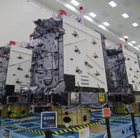
The U.S. Space Force’s Space Systems Command recently declared GPS III SV06, SV07 and SV08 satellites “Available for Launch.” Here, the space vehicles await official call up for launch in Lockheed Martin’s GPS III Processing Facility in Waterton, Colorado. (Photo: Lockheed Martin)
The U.S. Space Force’s Space Systems Command has declared the eighth GPS III satellite “Available for Launch.” This milestone marks the third space vehicle within the GPS III program to be declared available for launch in the past three months.
The next three GPS III satellites — SV06, SV07 and SV08 — are now awaiting official call up for launch in Lockheed Martin’s GPS III Processing Facility in Waterton, Colorado.
“SV06, SV07, and SV08 AFL milestones in just three months prove that GPS III production continues to benefit from efficiencies with each satellite delivery,” said Col. Edward Byrne, chief of SSC’s Space Production Corps’ Medium Earth Orbit Space Systems Division.
The first of the three recently completed satellites, SV06, is scheduled to launch in 2022 and will join the operational constellation of 31 GPS satellites.
GPS III satellites deliver enhanced performance and accuracy through a variety of improvements, including increased signal protection and improved accuracy.
GPS III also expands the civilian L5 signal, dubbed the “safety-of-life” signal, currently broadcast by the 12 GPS IIF satellites, but not yet operational, and delivers a new L1C signal designed to grant interoperability to similar international space-based position, navigation and timing (PNT) systems around the world.
As a crucial technological foundation for internet, financial, transportation and agricultural operations, GPS delivers the gold standard in positioning, navigation, and timing services supporting U.S. and allied operations worldwide.
Space Systems Command, located at Los Angeles Air Force Base in El Segundo, California, is the U.S. Space Force’s Center of Excellence for acquiring and developing military space systems. SSC’s portfolio includes space launch, global positioning systems, military satellite communications, a defense meteorological satellite control network, range systems, space-based infrared systems, and space domain awareness capabilities.
New modules enable users to develop high-precision solutions for heavy machinery, ground robotics, and unmanned aerial vehicles (UAVs).
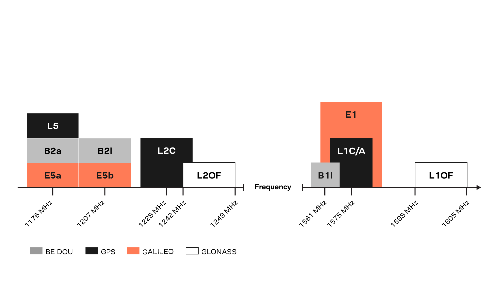
U-blox’s latest multi-band high-accuracy timing modules concurrently support L1 and L5 GNSS signals. The ZED-F9T-10B and LEA-F9T-10B timing modules, and the RCB-F9T-1 timing card, deliver nanosecond-level timing accuracies required to synchronize cellular network base stations and smart power grids. The ANN MB1 L1/L5 multi-band antenna completes the offering.
The multiband capability compensates for ionosphere error from all GNSS satellite constellations and reduces the timing error under clear skies to less than 5 ns without the need for an external GNSS correction service. To achieve maximum performance, the modules track signals from as many satellites as possible.
Image: u-blox
With satellite constellations transmitting signals on the L5 band nearing completion, the L1/L5 signal combination is becoming a viable option to complement products based on L1 and L2 signals. Modernized L5 signals are expected to deliver improved performance, especially in difficult urban conditions. Because L5 signals fall within the protected aeronautical radionavigation service (ARNS ) frequency band, they are also less subject to RF interference.
The LEA-F9T-10B provides a temperature range extended to –40 to +105° C. Both timing modules include a suite of advanced security features, including:
Improved anti-jamming and anti-spoofing technologies detect and flag malicious RF interference.
Secure boot ensures that the modules can only boot with authentic firmware.
Secure interfaces prevent intruders from tampering with the messages between the receiver and the host system.t
The ANN-MB1 L1/L5 multi-band antenna supports the GPS, GLONASS, Galileo and BeiDou, and addresses the scarcity of options in the nascent L1/L5 high-precision antenna mass-market, simplifying testing and deployment of L1/L5 multi-band GNSS solutions. Magnetic and fixed mounting options help meet diverse installation needs.
The new products targets developers in industrial navigation and robotics interested in high-precision positioning technology to locate UAVs, ground robots and agricultural equipment accurately and in real time.
Engineering samples of the u-blox ZED-F9T-10B, RCB-F9T-1 and ANN-MB1 will be available in May, followed by the LEA-F9T.