Tag: LAANC

  • Skyward collaborates with Pix4D mapping and modeling

    Screenshot: Skyward
    Screenshot: Skyward

    Skyward, a Verizon company, has announced its integration with Pix4D, a photogrammetry software suite for drone mapping. The partnership gives customers the ability to turn drone data into 2D maps and 3D models.

    Enterprises and drone pilots can now plan flights, receive approval to fly in controlled airspace with LAANC, fly with Skyward’s InFlight ground control station, and process data using Pix4D — all from within the Skyward platform.

    “Skyward has been bringing our customers tools to access airspace, plan and fly — now they can produce business-ready data deliverables without leaving Skyward,” said Mariah Scott, Skyward president. “Enterprises in construction, energy and utilities, and the public sector can get even more ROI out of their drone programs when combining Skyward’s drone management platform with Pix4D’s market-leading photogrammetry tools.”

    Skyward Mapping & Modeling, powered by Pix4D, enables customers to create, view, measure, and export 2D orthomosaic maps and 3D photogrammetric models right from Skyward’s web app. With the processing power of Pix4D, Skyward customers can get business-ready data sets through a seamless plan, fly, process workflow.

    “Enterprises are seeking to scale their drone operations and transform their businesses with better data and faster time to insight. Skyward’s platform, along with the power of Pix4D, delivers a powerful, comprehensive solution,” said Christopher Cressy, Pix4D managing director for North America.

    To learn more about Skyward’s mapping and modeling features, join a webinar on June 8 at 2 p.m. ET. Enterprises and commercial operators can try Skyward Mapping & Modeling powered by Pix4D free for 30 days.

  • FAA: Access to controlled airspaces advances drone, aviation safety

    FAA: Access to controlled airspaces advances drone, aviation safety

    Photo: RyanKing999/iStock / Getty Images Plus/Getty Images
    Photo: RyanKing999/iStock / Getty Images Plus/Getty Images

    The U.S. Federal Aviation Administration (FAA) has made it easier for drone pilots to quickly and safely access controlled airspace by adding 133 air traffic facilities to the Low Altitude Authorization and Notification Capability (LAANC) system. The expansion is based on feedback from the drone community.

    LAANC is an automated application and approval system for drone pilots requesting to fly below 400 feet in controlled airspace.

    As the FAA continues to modernize the national airspace to accommodate more users, the agency made LAANC accessible for 726 airports and 537 facilities, covering 81% of eligible airspace.

    LAANC is a collaboration between the FAA and the unmanned aircraft systems (UAS) industry which directly supports the safe integration of drones into the nation’s airspace. The service is accessible to all pilots who operate under the FAA’s small drone rule.

  • Skyward InFlight adds operations planning, LAANC to UAV app

    Skyward has updated its InFlight mobile ground control system app. It now offers operation planning and mobile LAANC requests.

    In October, Skyward released a major update to its airspace intelligence map on both web and mobile platforms. The update included a new airspace design, clear LAANC grids, and a redesigned user experience.

    It also integrated essential ground intelligence, including information on transmission lines, pedestrian walking paths, and 1 million vertical obstacles, as well as 3D views of key structures.

    The new features announced this month include the ability to create and plan flights from mobile device. Users can now plan flight areas, check airspace and deploy without leaving InFlight, directly from the airspace intelligence map.

    Users can now also make LAANC requests in the field to give users faster, greater access to controlled airspace. With LAANC, users can request access to airspace around airports and receive authorizations in near real time.

  • Skyward releases airspace maps, access for drone pilots

    Skyward releases airspace maps, access for drone pilots

    The drone operations management platform provides information on 3D vertical structures and obstacles, and access to digital airspace, to improve drone flight safety.

    Skyward, a Verizon company, has introduced Advanced Airspace Intelligence for drone pilots.

    Skyward’s drone airspace maps provide airspace data combined with essential ground intelligence including 3D views of key structures, transmission lines, and more than a million vertical obstacles.

    The platform also provides access to LAANC, the Low Altitude Authorization and Notification Capability program provided by the U.S. Federal Aviation Administration.

    Drone pilots in the field need to know how the surrounding area, including infrastructure, could affect flight, and Skyward offers this critical safety data to all users.

    Skyward introduces Advanced Airspace Intelligence from SkywardIO on Vimeo.

    “Showing airspace is important, but it’s only part of the picture. The more intelligence that is available to understand how an area will affect the flight, the less risk a pilot has in the field,” said Mariah Scott, president of Skyward. “Skyward Airspace Intelligence is the only solution that provides easy-to-understand data for things like transmission lines, runways, over a million vertical obstacles, and a 3D view of key structures. It’s the next best thing to physically being in the field.”

    In addition to comprehensive airspace information, the following data is now available for situational awareness:

    • Vertical structure obstacles (over one million structures identified from the FAA and FCC databases)
    • Major power transmission lines
    • Airports
    • Runways
    • Heliports
    • U.S. and Canadian National Parks
    • Stadiums
    • Hospitals
    • Schools
    • Pedestrian walking paths

    Skyward Airspace Intelligence is part of a complete workflow that enables pilots mitigate weather, environment and business-specific risks.

    Image: Skyward
    Image: Skyward
  • FAA provides more access to airspace to fly drones

    More than 100 control towers and airports have been added to the hundreds of Federal Aviation Administration (FAA) air traffic facilities and airports that currently use the Low Altitude Authorization and Capability (LAANC) system.

    LAANC is a collaboration between the FAA and industry that directly supports the safe integration of unmanned aircraft systems (UAS) into the nation’s airspace.

    LAANC expedites the time it takes for a drone pilot to receive authorization to fly under 400 feet in controlled airspace. By adding contract towers to the number of LAANC-enabled facilities, drone pilots will have access to more than 400 towers covering nearly 600 airports.

    In less than two years, LAANC has provided fast access to controlled airspace for more than 100,000 flights, according to Matt Fanelli, director of strategy at Skyward.

    Image: Skyward
    Image: Skyward

    “People have been asking the FAA to add more airports and today, 109 contract towers have now been added to LAANC.” Skyward has updated its 2019 LAANC Facilities Guide so that UAV pilots can easily reference airports near them that will be adding this service.

    Contract towers are air traffic control towers that are staffed by employees of private companies rather than by FAA employees. LAANC provides air traffic professionals with visibility into where and when authorized drones are flying near airports and helps ensure that everyone can safely operate within the airspace.

    The expansion to more than 100 contract towers means the FAA has further increased drone pilots’ access to controlled airspace safely and efficiently.

    LAANC is used by commercial pilots who operate under the FAA’s small drone rule (PDF) (Part 107). The FAA is upgrading LAANC to allow recreational flyers to use the system and in the future, recreational flyers will be able to obtain authorization from the FAA to fly in controlled airspace.

    For now, recreational flyers who want to operate in controlled airspace may only do so at fixed sites.


    Featured image: iStock.com/valio 84sl, via FAA

  • FAA process 50,000+ LAANC applications for UAVs

    FAA process 50,000+ LAANC applications for UAVs

    Photo: iStock.com/valio 84sl, via FAA
    Photo: iStock.com/valio 84sl, via FAA

    The Federal Aviation Administration’s (FAA) nationwide deployment of the Low Altitude Authorization and Notification Capability (LAANC) has exceeded all of the program’s original objectives.

    Since the program began with a prototype system in November 2017, LAANC has processed more than 50,000 applications from drone operators for authorization to fly in controlled airspace. The system now covers almost 300 air traffic facilities serving approximately 500 airports, providing near-instantaneous approvals and allowing operators to quickly plan their flights. View a list of the participating facilities.

    LAANC helps support the safe integration of drones into the nation’s airspace. The system uses airspace data provided through temporary flight restrictions, Notices to Airmen (NOTAMs) and unmanned aircraft system (UAS) facility maps that show the maximum altitude ceiling around airports where the FAA may authorize operations under Part 107, the small drone rule for commercial and public agency operators.

    LAANC Service Suppliers

    The FAA has approved 14 LAANC service suppliers. Instructions on how to apply are provided by each supplier:

    Aeronyde
    Airbus
    AirMap
    AiRXOS
    Altitude Angel
    Converge
    DJI
    Harris Corporation
    Kittyhawk
    Project Wing (X, The Moonshot Factory)
    Skyward
    Thales Group
    UASidekick
    Unifly

    Drone operators also can file for airspace authorizations using the FAA DroneZone, including for areas not covered by LAANC or when the operator holds a Part 107 waiver.

  • FAA approves 9 new LAANC service providers

    FAA approves 9 new LAANC service providers

    FAA also warns about drones interfering with public safety.

    The Federal Aviation Administration (FAA) has announced nine new partners to its Low Altitude Authorization and Notification Capability (LAANC) initiative, a collaboration between the FAA and the drone industry that provides near real-time processing of airspace authorizations for Part 107 drone operators nationwide who fly in controlled airspace.

    Following the FAA’s successful prototype, the initiative was simultaneously opened to additional air traffic control facilities and to new industry partners. The five-month onboarding process that began in April resulted in nine new LAANC partners — Aeronyde, Airbus, AiRXOS, Altitude Angel, Converge, DJI, KittyHawk, UASidekick and Unifly.

    The nine join five companies — AirMap, Harris Corp., Project Wing, Skyward and Thales Group — that have already met the technical and legal requirements to provide LAANC Services.

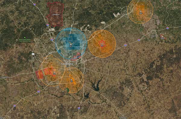
    LAANC uses airspace data, including UAS facility maps, which shows the maximum altitude around airports where the FAA may authorize operations under Part 107 in controlled airspace. The program gives drone operators the ability to interact with industry developed applications and obtain near real-time authorization from the FAA.

    LAANC, a foundation for developing the Unmanned Aircraft Systems Traffic Management System (UTM), is now available at nearly 300 FAA air traffic facilities across the country, covering approximately 500 airports.

    The FAA next year will accept applications from parties interested in becoming LAANC service providers from Jan. 7 to Feb. 8 and from July 8 to Aug. 9. This is not a standard government acquisition; there is no Screening Information Request (SIR) or Request for Proposal (RFP) related to this effort.

    Interested parties can find information on the application process here.

    FAA targets UAS violators for enforcement

    In a different announcement, the FAA said that drone pilots who interfere with fighting wildfires, law enforcement efforts, or other first responders such as medical flights  now are more likely to face serious civil penalties, even for first-time offenses.

    Deterring interference with first responders is critical as drone use expands exponentially. Firefighting aircraft trying to contain a wildfire have to suspend flights when a drone enters the area to avoid a possible mid-air collision. A drone flying over a crime scene or accident site can hamper police or medical aircraft operations.

    Ultimately, interference by a drone can cost lives.

    The FAA has provided guidance for agency personnel who handle possible drone violations to refer all cases involving interference with first responders to the FAA Chief Counsel’s office for possible enforcement action.

    In July 2016, Congress authorized the FAA to impose a civil penalty of not more than $20,000 for anyone who operates a drone and deliberately or recklessly interferes with wildfire suppression, law enforcement, or emergency response efforts.

    Under FAA guidance, inspectors generally use non-enforcement methods, including education, for correcting unintentional violations that arise from factors such as flawed systems, simple mistakes, or lack of understanding.

    However, given the potential for direct and immediate interference with potentially life-saving operations where minutes matter, offenders will immediately be considered for enforcement actions. Enforcement actions can include revocation or suspension of a pilot certificate, and up to a $20,000 civil penalty per violation.