The U.S. Department of Transportation (DOT) has approved $2.5 billion worth of bonds to help fund the Brightline West high-speed rail project connecting Las Vegas, Nevada, and Southern California.
The 218-mile line, estimated to cost $12 billion in total, will run along the I-15 median with electric trains capable of running at 186 mph.
The DOT previously approved private activity bonds of $1 billion for the project in 2020. The second tranche of private activity bonds brings the total to $3.5 billion. In December 2023, the DOT also awarded a $3 billion grant from President Biden’s infrastructure law to the Nevada DOT for the project.
In June 2023, DOT awarded a $25 million grant to San Bernardino County Transportation Authority (SBCTA) through the Rebuilding American Infrastructure with Sustainability and Equity (RAISE) Program to be used for the construction of the Brightline West stations in Hesperia and Victor Valley, California.
Brightline West is expected to break ground in early 2024.
Point One Navigation has been selected by the Indy Autonomous Challenge (IAC) to provide real-time kinematic (RTK) corrections technology to all autonomous racing cars at the Consumer Electronics Show (CES) in Las Vegas.
The Polaris RTK network offers centimeter-accurate location services, which makes autonomous racing at high speeds possible. IAC race cars often exceed 180 mph and require precise location data for safe high-performance racing. The IAC chose Point One Navigation based on the company’s proven record in delivering precise location data to users through its RTK technology.
Point One Navigation’s RTK technology is now available for a wide range of autonomous applications — including UAVs, robots, construction and farm equipment, and autonomous cars and trucks.
The race takes place on Thursday, Jan. 11 at the Las Vegas Motor Speedway. For more information, visit the IAC website.
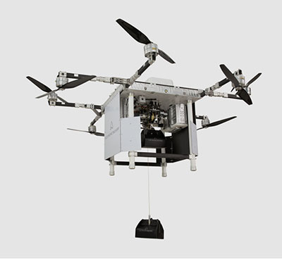
A2Z Drone Delivery LLC, developer of a patented tethered freefall drone delivery mechanism, has launched its RDSX commercial delivery UAV.
The company delivered the UAV in collaboration with a global logistics provider to deliver dual payloads per flight, helping drone service providers streamline deliveries while mitigating consumer concerns with residential drone delivery. The RDSX integrates A2Z Drone Delivery’s proprietary tethered freefall Rapid Delivery System capable of quickly and safely delivering payloads from altitudes as high as 150 feet. By keeping spinning rotors far from people and property, the RDSX helps mitigate consumer concerns with drone deliveries—such as the potential for property damage and intrusive rotor noise—and assuages some of the privacy concerns with low-flying unmanned aerial vehicles.
A2Z Drone Delivery will be showcasing the new RDSX at the Commercial UAV Expo (September 7-9, 2021 in Las Vegas, NV).
The RDSX is a flexible drone delivery platform capable of carrying dual payloads each weighing up to two kilograms on a round trip of up to 18 kilometers. Alternatively, it can be configured with a single tether to expand its range out to 30 kilometers. The controlled-freefall delivery method it employs allows UAV service providers to reduce time-on-station to a minimum by delivering the package to the ground in seconds and eliminating the need for the drone to touch down. By maintaining its altitude throughout the delivery, the RDSX keeps spinning rotors away from people and property, mitigating consumer concerns and enabling it to deposit payloads into areas congested by trees, wires, or other dangerous obstructions.
The integrated A2Z Drone Delivery app combines manual control system operations with an onboard computer and sensor array to manage the package’s controlled-freefall and gentle stop before the ground. With the package delivered, the RDSX’s Kevlar tether and auto-release mechanism releases the payload before being reeled back up for reuse.
A2Z Drone Delivery’s freefall delivery technology has previously been leveraged for residential drone delivery trials, deployment and retrieval of ground sensors for energy exploration, as well as for shore-to-ship port delivery. The technology is equally applicable for first responders delivering life-saving medicine, for search and rescue professionals quickly deploying equipment to remote areas, or for rapidly collecting samples throughout an expansive mining facility.
The RDSX leverages a proven UAV flight platform equipped with a pair of cameras allowing pilots to navigate beyond visual line of sight (BVLOS). Additionally, the system features an independent downward-facing LiDAR sensing system to stream continuous data to the onboard firmware which controls the payload’s rapid descent and allows the pilot to visually monitor payloads through flight and delivery. Featuring quick-swap bucket-style batteries to limit downtime between flights, the RDSX can operate in diverse conditions including temperatures ranging from -20 to 45 Celsius, in up to 95% humidity, and from elevations up to 4,800 feet. Additionally, the RDSX’s eight rotor arms, fitted with durable carbon fiber propellers, can fold away for easy transport of the drone.
With its patented delivery system, A2Z Drone Delivery, LLC is developing innovative solutions to enable safe, accurate and low-noise drone deliveries. Its flagship delivery system, the RDS1 (Rapid Delivery System) enables payload delivery and retrieval to locations where most UAVs are unable to land, and its RDSX is a commercial multi-payload delivery system designed to meet the needs of the growing drone delivery industry. Based in Los Angeles, A2Z Drone Delivery originated as a drone delivery project at Brown University in 2016.
“Seen & Heard” is a monthly feature of GPS World magazine, traveling the world to capture interesting and unusual news stories involving the GNSS/PNT industry.
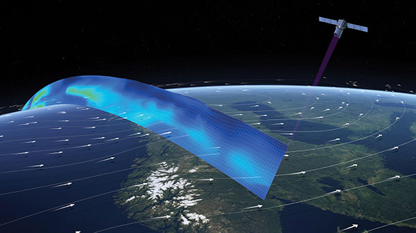
Image: ESA
Caught in a vortex
This winter’s polar vortex blasted the northern hemisphere. Understanding the vortex is the mission of the European Space Agency’s Aeolus satellite. Sudden stratospheric warming can disrupt the vortex, as it did this winter, causing the strong wind around the edge of the polar vortex to weaken or reverse (the processes involved are not fully understood). Aeolus emits short, powerful pulses of ultraviolet light from a laser and measures the Doppler shift from the light scattered back to the instrument from molecules and particles to deliver profiles of the horizontal speed of the world’s winds.
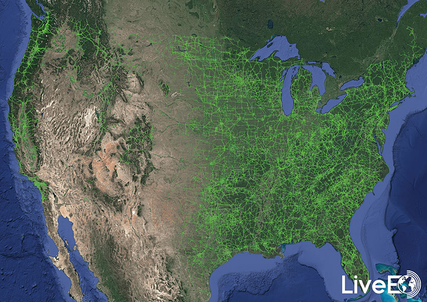
Image: LiveEO
Encroaching vegetation
For the first time in history, according to Berlin-based start-up LiveEO, vegetation encroachment risk to the U.S. transmission grid has been analyzed from space. LiveEO used more than 15,000 satellite images to evaluate risk to 574,000 miles of electricity lines. The analysis covers the detection of vegetation along transmission corridors, as well as identification of grid segments exposed at dangerously close distances. Globally, vegetation causes up to 56% of externally triggered power interruptions.
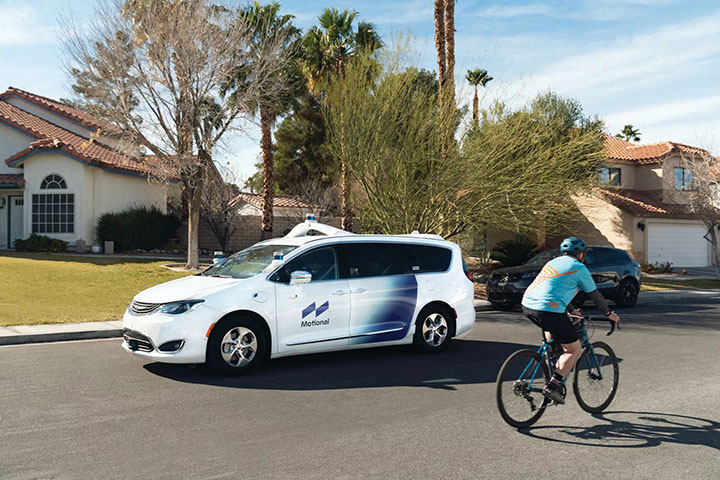
Photo: Motional
What happens in Vegas
The Hyundai-Aptiv joint venture Motional in February tested its vehicles without safety drivers in Las Vegas. The tests came less than three months after the company received the green light from the state of Nevada to test its vehicles without a human safety driver. The vehicles navigated intersections, unprotected turns and interactions with pedestrians and cyclists. A Motional employee rode in the passenger seat and was capable of stopping the vehicle if needed.
On April 2, a new museum exhibit will open that focuses on the U.S. Air Force’s role in the management of GPS satellite systems.
The National Museum of the United States Air Force is holding a grand opening event for the new GPS Exhibit from 2-3:30 p.m., with remarks by U.S. Air Force personnel involved with the exhibit followed by light refreshments.
The museum is located at 1100 Spaatz Street, Wright-Patterson Air Force Base, Riverside, Ohio.
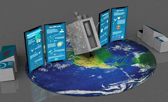
On April 2, 2020 a new exhibit will open focusing on the U.S. Air Force role in the management of GPS satellite systems. (Artist’s concept: USAF)
History and Benefits. GPS began as a military navigation tool in the early 1960s. Later, the U.S. Air Force became the lead organization for developing the system. It manages the system, providing highly accurate position, navigation and timing information to users worldwide, for free.
The exhibit describes what GPS is and how it works by outlining satellite and ground systems and their historical development. It explains how atomic clocks and GPS satellites enable all kinds of important activities.
These include mapping and navigation for everyday users and the military, commerce, farming, construction, cell phone systems, the power grid, and climate research.
The exhibit also explains how satellite orbits work, and it outlines the problem of “space junk.”
Hands-on. Interactives and videos help all ages better understand GPS, learn how to find their location on the Earth, and see how orbits and satellites work.
The museum will be open late on opening day, allowing guests to tour the museum until 8 p.m., with an opportunity to walk inside an AC-130A. The Lockheed AC-130 gunship is a heavily armed, long-endurance, ground-attack variant of the C-130 Hercules transport, fixed-wing aircraft.
The exhibit opening will take place in the Space Gallery (fourth building).
Regulus Cyber is showcasing its anti-spoofing GNSS receiver at the Consumer Electronics Show, being held Jan. 8-11 in Las Vegas.
Previously introduced in our Launchpad feature, the Regulus Cyber solves GNSS spoofing attacks that threaten the automotive, aviation, maritime and mobile industries with a unique technology applicable both as a fortified GNSS receiver, capable of detecting spoofing attacks, and at the chip level, allowing mobile phones, cars and internet of things (IoT) devices to receive GNSS spoofing protection for the first time, the company said.
The company was able to miniaturize its technology into a form factor that provides customers more flexibility with integration.
The Regulus Pyramid GNSS Receiver is a fully functional GNSS receiver, fortified with the spoofing detection capability. The receiver contains patented technology that enables it to differentiate between real GNSS signals and fake ones generated by an attacker.
The Pyramid GNSS receiver is a direct replacement to any automotive GNSS receiver. The upcoming chip-level technology offers both spoofing detection and spoofing mitigation to any GNSS-based device, including mobile phones, the company added.
The Spoofing Problem. Any vehicle guided by a GNSS system can be spoofed using open-source software and a software defined radio (SDR) legally purchased from Amazon for under $300. A spoofer can generate and transmit fake GNSS signals that can be used by the vehicle’s navigation system to calculate a false destination, directing the vehicle to an entirely different location, a potentially life-threatening hazard.
In addition, spoofing is a growing concern to any application or device that uses satellite positioning, navigation or time. While real attacks are expanding, anti-spoofing solutions remain a luxury that only high-end, defense markets can afford.
While current solutions are big, heavy and expensive, Pyramid GNSS offers industry-standard size and price. Industries such as automotive, aviation, maritime, and mobile phones can defend themselves against this sophisticated emerging threat, at an affordable price and relevant size, power consumption and weight, the company said.
“We designed our product to be a fraction of the size that is currently available on the market so that all types of companies – whether it is a car manufacturer or telecom provider relying on GNSS – can integrate it seamlessly,” said Yonatan Zur, CEO of Regulus Cyber. “GNSS spoofing will need to be a major security focus during 2019 since it leaves so many industries vulnerable to attacks.”
To meet Regulus Cyber at CES, visit booth #2602 at the Westgate.
UPDATE: Denis Villeneuve’s Blade Runner 2049 took home the Oscar for Achievement in Visual Effects on March 4. Visual effects supervisors John Nelson, Paul Lambert, and Richard R. Hoover, plus special effects supervisor Gerd Nefzer, took the stage to accept the award.
Framestore, a visual arts studio in Montréal, Québec, has received an Oscar nomination for Best Visual Effects made possible, in part, by Esri CityEngine.
Designers at Framestore used the software to create a detailed futuristic city based on present-day Las Vegas for the movie Blade Runner 2049.
“We were tasked in creating a futuristic Las Vegas for the year 2049. We had to fly over the main strip of Vegas on a long sequence shot,” said Didier Muanza, lead environment TD, Framestore. “CityEngine seemed to be the best choice to help us generate a modern-day model of Vegas, which was used as the base for the futuristic version.”
Esri CityEngine is a sophisticated 3D modeling software used in professions such as urban planning and architecture as well as film and other entertainment industries. Esri is a global spatial analytics company.
Framestore designers used CityEngine for only one month, yet generated a set that was 6.759 kilometers long and 4 kilometers wide and included more than 1,400 buildings. Realistic textures were based on aerial and oblique photos of the Las Vegas main strip.
Blade Runner 2049 has already received the BAFTA award for Special Visual Effects. The 2018 Academy Awards ceremony takes place Sunday.