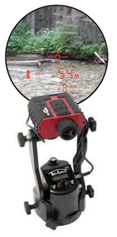
Laser Technology Inc. (LTI), manufacturer of professional-grade laser rangefinders, has released its improved TruPulse 360 laser, which features LTI’s TruVector 360° Compass Technology.
The rangefinder has numerous measurement capabilities. According to the company, it can measure slope distance, inclination and azimuth; instantly calculate horizontal and vertical distances; and calculate 3D missing line values.
The enhanced device offers 33 percent increased distance accuracy, 25 percent better target acquisition and a higher azimuth accuracy of 0.5° root mean squared (RMS).
“Given its limitless angle and tilt capabilities, the TruPulse 360 is extremely popular for GPS/GNSS offset mapping processes,” said Eric Miller, president of Laser Technology Inc. “The laser’s flexibility enables users to record offsets and attribute data of multiple features from a single location, making data collection quicker, easier and even safer in potentially hazardous situations.”
The new TruPulse 360 continues LTI’s mission of providing cutting-edge laser measurement solutions in an easy-to-use way, and this model represents an accumulation of more than a decade of work.
In 2007, the TruPulse 360 integrated LTI’s exclusive TruVector 360° Compass Technology, which was developed from the company’s stand-alone MapStar compass module. The combination of an integrated compass, inclinometer and distance laser gave measurement professionals the best possible azimuth accuracy — and mapping-grade precision — no matter the angle it was shot in, the company said.
Features
Photo: LTI
This latest version of the TruPulse 360, with an even more accurate electronic compass integrated into the laser, continues to deliver added value for the modern measurement professional. Uses include forestry, utilities, construction and GIS mapping.
In addition to its increased range and azimuth accuracy and Bluetooth-enabled communication, the TruPulse 360 features:
Reflectorless technology that enables data capture to any surface type;
advanced targeting modes to achieve accurate, repeatable results of the intended target;
seven-power superior optics technology that displays all measured and calculated solutions; and
Smart technology that recognizes adverse measurement conditions and prompts recalibration.
“By integrating our great compass technology into this already groundbreaking device, no other laser on the market can match the performance of the TruPulse 360,” Miller said. “And with our continuous commitment to making user-driven enhancements, the TruPulse 360 stands on its own as the best measurement and mapping laser rangefinder out there.”
Using lasers in conjunction with GPS can collect richer data, faster, and streamline survey and mapping projects across many disciplines that draw on mapping and geospatial information systems.
To learn more about the exact processes involved in Integrating a professional measurement and mapping laser to your GIS toolbox, both saving time and enabling collection of additional attribute data attend GPS World’s free webinar on Thursday, Aug. 16: LaserGIS: Your Gateway to Collect More GIS Data in Less Time.
The webinar will be available for download 24 hours after broadcast time, for those unable to attend live.
The applicable fields for this enabling technology include surveying, construction, ecosystem management, watershed analysis, geological mapping, environmental impact assessments and more.
Photo: Laser Technology Inc.
A natural resources ecosystem manager said, “I map areas that are either impossible to occupy or simply can’t be disturbed, so using laser-based reflectorless measurement technology is ideal for wildlife habitat research. When performing soil surveys, I can easily calculate the grade of a slope by using the missing line routine. I even used the Laser Technology TruPulse once to track the progress of a wildfire. This technology is a must-have for our crews because it’s highly portable and produces reliable data.”
A land conservation specialist performing watershed analysis added, “Stream channel surveying tools have come a long way since I graduated college. I’m now able to mark a stream’s course, calculate the gradient and measure the width of the riparian zone, all with a simple point-and-shoot TruPulse laser. For wetland delineation projects, being able to shoot directly to the bank saves a huge amount of time and keeps me and my crew as dry as possible.”
A geologist performing mapping as part of his work routine said, “I need to accurately track geological structures in mines and outcrops, and would really struggle with collecting measurements if it wasn’t for my TruPulse 360. With the laser, I can get a measurement to any type of surface and don’t have to stand in dangerous areas, so I can be extremely productive and safe. When I have to verify the volume of our biomass stockpile, I just integrate my laser with MapSmart and get reliable calculations in minutes, right in the field.”
Finally, an archaeologist performing an environmental impact assessment stated, “Conserving archaeology sites is just as important as researching and analyzing them. Integrating the TruPulse with GPS allows me to make better planning decisions with all types of resource considerations without compromising data integrity or delicate areas. The TruPulse’s onboard solutions for height and 3D missing line make my job so much easier and far more productive than conventional measurement tools.”
From left: Esri Program Manager Doug Morgenthaler, Laser Technology Sr. Product Manger Derrick Reish and Eos CTO Jean-Yves Lauture. (Photo: Eos Positioning)
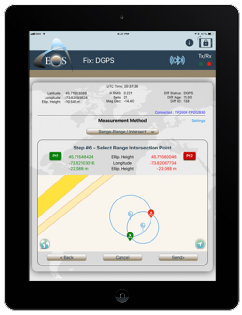
The three-way partnership will enable field crews to collect centimeter-accurate 3D data in GNSS-impaired environments.
When combined with Laser Technology Inc.’s (LTI’s) laser rangefinders, the solution will allow field crews to capture centimeter-accurate 3D locations of hard-to-reach assets and in GNSS-impaired environments.
“By combining the high-accuracy of the Eos Arrow Series GNSS receivers and the laser capabilities of LTI, we can empower field crews to capture highly accurate XYZ coordinates from a safe distance,” LTI Senior Product Manager Derrick Reish said. “This eliminates the need for physically occupying every point. It also provides more accurate location data, with a more affordable mobile asset-management workflows.”
The Arrow Gold. (Photo: Eos Positioning)
The solution has been in the works for months, as demand has grown for hard-to-reach, high-accuracy mapping within the Collector workflow.
“Eos is extremely grateful to be a part of this initial release in high-accuracy asset location data with LTI’s laser rangefinders and Esri’s Collector mobile app,” Eos CTO Jean-Yves Lauture said. “Enabling this kind of accuracy means even the most budget-conscious field crews will be able to access the location of their hard-to-reach assets.”
All three teams have been working closely to ensure a seamless integration with Collector and ArcGIS Online. When using an LTI laser rangefinder and an Eos Arrow Series receiver with Collector, a field worker can easily shoot, capture and share high-accuracy 3D location data that is streamed into ArcGIS Online in real-time.
Image: Eos Positioning
The solution is expected to be particularly useful in urban corridors, highway settings, forested (or wetlands) areas, and other areas where assets are hard or dangerous to occupy. This will both increase accuracy and efficiency, as well as decrease safety liabilities in dangerous situations, the companies said.
“Esri is extremely pleased that Collector can now support the capture of high-accuracy asset locations from afar, leveraging our unique partnership with both Eos and LTI,” Esri Product Manager Jeff Shaner said. “This is a game changer for asset management.”
Prior to this release, field crews challenged with capturing high-accuracy 3D locations for hard-to-reach assets would need to use a total station with a different software workflow and then mesh the data back in the office, a clumsy and inefficient workflow requiring lots of additional training and expertise. With the new workflow, field crews can operate in GNSS-impaired environments at a high-accuracy level without leaving the Collector/AGOL environment, creating a highly efficient workflow.
The solution has been designed to provide several offset-mapping methods.
“The implementation of several measurement methods gives users the freedom of choice, so they can pick the right laser option which meets their accuracy needs,” Reish said.
Eos will unveil its offset measurement solution for Collector at the upcoming Esri User Conference in San Diego. For a field demonstration of how the solution works, attendees can visit Eos at booth #1019 during the conference, and attend the session “LaserGIS for Everyone: How to Combat Costly and Tedious Data Collection Workflows” at 10 a.m. on Wednesday.
Over the past two years, I’ve been sharing my view on land surveying over a variety of topics. One of the constant themes I try to maintain is technological improvements and how surveyors need to continue to embrace new applications and equipment.
While I will also argue that we cannot forget our surveying roots (see GPS World, March 2017), we still need to keep an eye on future technologies, means and methods to increase our productivity and profitability as well.
With this idea of peeking at the road ahead, I traveled to Berlin, Germany, to cover Intergeo 2017, an international trade show for everything geospatial.
Held every year at different venues around Germany, Intergeo is the world’s largest conference and exhibition for geodesy, geoinformation and land management. The theme of the conference this year was “We are bringing worlds together,” and based upon the number of vendors, new equipment and applications, and record breaking attendance, it was quite evident they hit their mark.
The numbers were astounding: 580 vendors from 37 countries, 18,000+ visitors from 100+ countries, all packed in six interlinking halls covering more than 325,000 square feet (7.5+ acres). When I spoke with several contemporaries who previously attended Intergeo, all warned me to be ready for the size and scale of the facility, the number of vendors, and the large spaces occupied by the big survey players. Truly thinking this rhetoric was hyperbole, I went with guarded expectations. Boy, was I in for big surprise.
Walking up to the entrance, one could sense immediately the size and enormous presence of this conference. The registration lines were easy and efficient, with plenty of entry gates and attendants to help with any information. When I entered the first hall for my initial visit, the prior warnings about the size and scale were quite true. This conference was three days long, and I knew I was going to need every minute to cover all the bases.
My account here is broken into four sections — one hall per day. Leica, NovAtel, Laser Technology and Septentrio were among the first booths I encountered on day one. Javad, ComNav, Hemisphere and Emlid were in the next hall over, and can be found below “Behind Door Number Two.” Day three found me hobnobbing with CHC Navigation, EOS and Swift Navigation; look for them under “I’ll Take Hall Three for $200, Alex.” I topped off my Intergeo experience interviewing NavCom, Tersus and Trimble in “The Big Finish (Or Is It?)”
ENTERING ANOTHER DIMENSION…
Coming into Hall 1.1, the first thing that catches one’s eye besides the vastness of the entire space is the size and depth of the Hexagon exhibit. Hexagon is the parent company of Leica, NovAtel, and several others, and all were there displaying new products and software for a multitude of geospatial needs.
I was introduced to the new Leica GS18T GNSS RTK rover (Leica Geosystems debuts GNSS RTK rover at Intergeo 2017) with many new upgrades, including being able to measure a point while the unit is not being held plumb. Yes, you read that right; the unit has an inertial measurement unit (IMU) built in that compensates for any rod tilt and corrects the location back to the bottom of the rod. Now it is possible to collect a GNSS location to places and objects no longer thought possible.
This feature has been available with the “J-Tip” from Javad for the past year: now Leica has added the capability to the GS18T.
While the demonstration took care of my skepticism of the unit, it raised different concerns with the field personnel using it. This method of “no bubble” is fine for this unit, but I can envision crews getting sloppy with conventional GNSS and total station prism rods when mixed with this new technology. This will increase the need for proper training and trust that the all rod-based equipment is used in its intended manner and procedure.
NovAtel was on hand with presentation of a full line of GPS receivers, boards and peripherals, including its GAJT line of anti-jamming receivers as well as an “interference” toolkit of analyzing software modules. With the solid product line and software, the company motto of “assured positioning” bodes well for its users.
Laser Technology Inc. has provided many measurement breakthroughs over the past few decades, and its introduction of the TruPoint 200h is no exception (see Laser Technology highlights TruPoint 200h at Intergeo 2017). The company has taken the TruPoint 200 line of measuring devices and expanded its capability with phase shift and pulse diode measurements, which means the unit will determine the most accurate method based upon reflectivity. This is also paired with a data collection and reporting application on your Android smartphone to greatly expand your ability to share your data.
Also at Intergeo introducing a new GNSS receiver was Septentrio, a navigation systems developer from Belgium. Septentrio was showing the Altus NR3, a lightweight multi-constellation receiver aimed at the surveying and mapping community. This new unit boasts an AIM+ system designed to monitor and protect the user’s data from jamming and spoofing so the collected data is confidently accurate.
Carlson displayed its new BRx6 multi-GNSS receiver along with the RT3 tablet data collector. The BRx6 receiver expands the Carlson family of GNSS products to include connection to most RTN systems worldwide as well as the Atlas L-band correction service that is beginning to gain many followers. Paired with the new RT3 tablet, these products continue the look, feel and service that Carlson users have enjoyed for many years.
Sokkia was there with a full complement of surveying and monitoring equipment, with the GCX3 GNSS receiver being the main focus of their new products. This unit sets the bar even higher for light and efficient GNSS receivers as it weighs only 440 grams with the batteries, yet is more capable than many similar systems on the market.
Another new GNSS receiver introduction was from Hi-Target, the iRTK-5. This new model is the one of the first units to have an OLED touchscreen on the receiver. It supports reception from all major GNSS constellations as well as the L-band correction service. Hi-Target prides itself on a new proprietary differential correction technology that analyzes the integrity of data from all sources before providing a position. This model also has a 4G LTE chipset that will communicate with almost all cellular systems worldwide.
One thing that stood out to me that differs greatly from surveying in the U.S. is the proliferation of monuments and monitoring points/devices used by surveyors throughout the world. So, the multitude of vendors offering varying kinds of targets, prisms, and survey point markets should not have shocked me, but it still did. It was quite impressive with the walls of targets and prism assemblies for many different applications along with the tables of nails, tablets, monuments and vault systems used by surveyors worldwide. Among the notables were Rothburcher Systeme and Bohnenstingl, who both offer a complete line of products beyond most surveyor’s imaginations.
The Juniper Systems booth showcased the Mesa2 rugged tablet and the Geode sub-meter GNSS receiver, both designed with efficient mapping collection in mind at an affordable price point, yet rugged enough to take on most environments. They were also highlighting their CT5 rugged smartphone and CT7G rugged tablet as solid products for any surveying and mapping data collection need.
BEHIND DOOR NUMBER TWO
After navigating the first of four conference areas, I wondered if all the remaining halls would be just as impressive. Hall 2 did not disappoint, as the exhibit spaces were just as big and remarkable as the first one.
Already a major entity within the GNSS community, Javad came to Intergeo 2017 to introduce its entry into the UAV market, the Triumph F-1. Unlike other UAVs, this unit was designed starting with the GNSS engines Javad is known for; engineers then built the flying craft around the brains of the system. It utilizes the same DNA of the Triumph-LS receiver along with ease of Javad software, all on a multi-rotor platform with hot-swappable batteries.
Aimed for more agricultural users, ComNav introduced a lightweight GNSS receiver, the T30, and a new software guidance system compatible with most tractor configurations. This system is designed to be more efficient and precise than OEM tractor guidance as well as more customizable for the user.
The company behind the new Atlas L-band correction service, Hemisphere GNSS, also provided introductions to several new products at Intergeo. In addition to several navigation chipsets for OEM use, they also introduced the 321+ GNSS Smart Antenna. This new receiver is multi-frequency and multi-GNSS with an Athena RTK engine and Atlas L-band global corrections to cover most positional needs. With hot-swappable batteries, this unit will run over 12 hours on two sets that are provided.
EMLID may be a newcomer to the GNSS environment but they are making noise by offering new products and technology at price points for more consumers. At Intergeo, they were demonstrating the Reach RS GNSS receiver with RTK capability, the Reach GNSS module for UAV systems and the Edge module, an advanced drone controller with HDMI video input and 5.8 GHz data link. These guys are my sleeper pick for becoming a bigger player in the very near future.
Topcon’s space, which included industry partner Intel included an interactive dome using their “Immersive Point Cloud Workspace” software and 3D point cloud data to give attendees a virtual reality tour of sites previously mapped with Topcon equipment and software. This four-meter dome was a popular stop with visitors, as was the product introductions of their SmoothRide software and the MAGNET Collage desktop mass data processing software. In addition, another product showcased in conjunction with Intel was their UAV systems, led by the Sirius Pro fixed wing vehicle and the Falcon 8 multi-rotor vehicle.
The main presentation from Bentley to the surveying/GNSS community was the increased capability of their ContextCapture software module. With 3D point clouds and virtual reality systems become the norm, Bentley has upped their game with visualization tools and features within this module not found in many point cloud software packages. The biggest improvement is the ability for survey-grade data acquired through laser scanning, LiDAR and photogrammetry to be easily input and manipulated for many different uses. From BIM to roadway corridor modeling and asset management, these improvements are making the utilization of 3D data more seamless.
Something that caught my eye initially as a novelty was TinyMobileRobots, a Danish company producing a small unmanned cart for marking surfaces. They currently have three products: the TinySurveyor, the TinyLineMarker, and the TinyPreMarker. All have GNSS receivers that operate autonomously on a predetermined route and carry a paint can for marking specific points. From marking athletic fields to paint striping, they might be on to something quite unique but very cool.
I’LL TAKE HALL THREE FOR $200, ALEX
Hall 3 brought us to CHC Navigation and their full range of surveying and mapping products. Highlighted during our discussions with them was the M6, i70 and i80 GNSS receivers and the Apache 5 USV boat for hydrographic applications. It was quite evident how large of a company CHC is and how vast their global presence is so don’t be surprised to see them in North America soon.
EOS Positioning Systems is another smaller GNSS receiver producer that is targeting the mapping community with the lower entry pricing and smartphone application interfacing. From the basic L1 receiver for mapping to the multi-constellation, triple-frequency model including Atlas L-band corrections, EOS is providing an easy to use package at an affordable price point.
Another entry in the OEM board/system provider of centimeter-level accuracy systems is Swift Navigation and their Piksi line of products. From agricultural applications to autonomous vehicle positioning, they are providing navigational systems that will guide our future. As the surveying community expands its use of unmanned vehicles, I would not be surprised to see Swift at the forefront of this effort.
Another member of the Hexagon family, the Geomax display was loaded with everything imaginable for measuring and remote sensing. The main introduction for Intergeo 2017 was X-PAD Office Fusion, an all-in-one software package that allows the data from various sources to come together in one place for creating and manipulating 3D models. While I was not familiar with Geomax, it was quite evident that their customer base, while European-centric, was big and quite loyal to the brand.
A newcomer to the surveying world is Pix4D and their photo processing software. Used by many UAV enthusiasts and now surveyors, Pix4D has quickly become one of the largest providers of software for creating orthometric photos that are georeferenced to known coordinate systems and GIS databases. Most of their success has been because of ease of use and affordability versus the leading surveying software packages. They are also industry partners with Esri and DJI, so having big friends in popular places has helped their cause. Look for more great stuff from them for surveying applications in the near future.
THE BIG FINISH
As I entered Hall 4, I began to wonder if I was done with the major attractions and getting into the bit players. I was wrong.
The first stop was Geozone, who was introducing a new receiver, Falcon SF, through a collaboration with NavCom. This new unit features multi-constellation and multi-frequency collection, but also includes Starfire, a global system designed and maintained by NavCom that is a satellite-based correction signal and provides accuracy of 5 CM anywhere in the world. This correction system comes standard with a subscription when you purchase the receiver, which is unheard of in most surveying environments. This is another product I predict that will be making more of a global presence in short time.
Tersus GNSS was at Intergeo to introduce many OEM navigation boards and an RTK system for surveyors and autonomous control systems. The Tersus David RTK system is designed to turn your smartphone into a high accuracy GNSS data collector. This system is highly durable and compact so it will accommodate many different mapping needs.
Another company that has global reach but not much exposure to U.S. business, South Surveying & Mapping Instruments, wouldn’t give an attendee the impression that they are a small player in the surveying world. Their exhibit space was impressive, ranging from simple theodolites to high accuracy robotic total stations, RTK GNSS receivers and fixed-wing/multi-rotor UAVs.
As lidar technology becomes more available and affordable, a stop at the Riegl booth was a must. They were introducing many new products at the Intergeo 2017 show, including the miniVUX-1DL UAV laser scanner for multi-rotor and fixed-wing aircraft. This little beauty weighs under 3 kg and fits on most scalable UAV platforms.
Another fun item on display was the VMX-2HA Dual Scanner Mobile Laser Scanner, which looks like a high-tech octopus on top of your vehicle. This unit collects 2 million measurements per second as well as 9 x 12MP camera images at various angles. As the miniaturization of technology continues, I see RIEGL continuing to lead the lidar segment well into the future.
Just when I thought I was almost done, I realized that there was one major player left that I had not seen: Trimble. They were in the back of Hall 4 across almost the entire width of the conference space. Everything geomatics, remote sensing, and navigation; it was here in one of the biggest exhibition spaces at Intergeo 2017.
All the latest surveying instruments were here, including the R10 GNSS receiver and SX10 scanning total station. The new items for surveying at this show were numerous; the C3 and C5 mechanical total stations with autofocus, Catalyst software with GNSS receiver for smartphones, the T10 rugged tablet for survey and GIS applications, and OEM receiver boards (BD940-INS, BD992-INS and BD990).
Also included within the Trimble space were Nikon and Spectra Precision branded instruments as well as the latest acquisition, Applanix GNSS-aided inertial movement systems. While Trimble has grown considerably in the past decade, it seems as nothing will slow them down. If they continue to introduce great products and technology, I wouldn’t bet against them.
BUT WAIT, THERE’S MORE…
There were three more halls, with two of them being organizations and information booths. Hall 6, however, has grown into a standalone space as “Interaerial Solutions,” Europe’s biggest UAV show. All the main players were in here (including DJI, DroneDeploy and over 150 more) so almost everything imaginable with UAVs can be found here.
During the conference, the adjacent courtyard was utilized for UAV demonstrations and product introductions. It will be interesting to see in the coming years if this segment of measurement and remote sensing will continue to expand with number of vendors/suppliers or if it will get absorbed by many of the bigger players within the geomatics community.
INTERGEO 2017, IN RETROSPECT
The common theme/message through this gathering was digitalization, “smart cities” and the evolution of the occupations that work within these environments. Intergeo is an impressive gathering of likeminded people discussing how to manage the increasing waves of data through technology, analyzation and thought processing.
While I can’t say that these types of gathering do not happen in the U.S., it is not as obvious as the annual assembly of Intergeo in Germany. The surveying community in the United States needs to hold a similar “summit” to help guide the profession toward its future goals. The one thing I have always appreciated about surveying is how it does embrace technology and forward thinking yet must rely on the past to tell us where we have been.
Digitalization is here and cities will get smarter with or without us, so it’s up to us as surveyors to keep looking forward with the times. Global measurement and navigation will be a big part of that, so let’s put our thinking caps on to see what we learn next.
Until next time, guten tag und gute gesundheit.
A big thank you also goes out to my fellow Intergeo members Ryan Gerard, Mike Joyce, and Allison Barwacz for making this a wonderful experience.
New features are now available for TerraGo Magic, including laser-rangefinder integration, offset data capture, Apple and Google turn-by-turn navigation, and proximity alerts. Also new is extended waypoint guidance for finding off-road assets and infrastructure.
TerraGo Magic is a zero-code platform-as-a-service that enables customers to build their own custom mobile apps without writing any code by choosing from a menu of available, field-tested features.
TerraGo Magic is also the underlying platform used to build TerraGo Edge, which includes these latest features in version 4.1, available for download from the iTunes App Store and Google Play.
“With the addition of laser positioning and offsets for remote data collection, TerraGo helps us rapidly capture high-accuracy data for more assets and infrastructure, even those in difficult to reach locations,” said Fernando Mutia, IS supervisor for San Jose Water Company.
Partnership with Laser Technology
TerraGo is now partnering with Laser Technology Inc. (LTI) to enable all custom apps built by TerraGo Magic to seamlessly utilize LTI’s professional-grade laser rangefinders.
TerraGo Magic partners and customers can now add TruPulse rangefinder support to their custom iOS and Android apps with the click of a button using the TerraGo Magic zero-code app platform.
Also, Seiler Instrument – Geospatial, a partner of both LTI and TerraGo, will now add TruPulse support to its new Field2GIS app, which was built using TerraGo Magic and is now available from iTunes and Google Play.
“We’re very happy to launch this partnership that we feel responds directly to our customers’ goals and the industry’s demand for improving the quality and productivity of their field data collection work,” said Derrick Reish, senior product manager at LTI. “By leveraging laser precision and cloud-based mobility, we can help our joint customers collect the accurate data they need at a level of efficiency that wasn’t possible just a few years ago.”
“With TerraGo Magic, we totally change the traditional way of thinking about how custom mobile app versions get built, released and upgraded,” said Dave Basil, vice president of product development at TerraGo. “When we publish a new feature in Magic, it’s immediately available to all customer apps but doesn’t force it on all customers or require an upgrade beyond their control.”
“With TerraGo Magic’s platform-as-a-service, customers can evaluate and include features based on their priorities, timeline, business requirements and users’ needs, giving them the flexibility and control of a custom solution without the cost of custom app development,” Basil said.
Webinars
TerraGo is hosting a webinar on Aug. 15 at 12 p.m. ET with a live demonstration of the latest features in TerraGo Magic Apps and TerraGo Edge.
To learn more about the technical details and operational benefits, join TerraGo and LTI in the webinarAdvanced Mobile Data Collection Finds the Range with Laser-Precision, on Aug. 22 at 12 p.m. ET.
Laser Technology Inc. introduced its handheld TruPoint 200h hybrid laser measurement system at Intergeo 2016, which waqs held Oct. 11-13 in Hamburg, Germany. TruPoint 200h combines phase and pulse technology in indoor and outdoor environments.
Laser Technology Inc. (LTI) is offering a close-up look at its new geospatial information systems (GIS) technology at the 2016 Esri User Conference, which is being held June 27 to July 1 in San Diego, California.
Attendees are invited to stop by booth #2525 to discover how LTI can help professionals stay connected and map smarter by using its lasers and a personal smart device. The company will be handing out vouchers for a complete mapping solution, which could save GIS professionals hundreds of dollars.
The New TruPoint 300 with MapSmart on Android, by LTI.
The company’s MapSmart on Android software combines all of the sophisticated technology that is typically required to collect field data and puts it into a straightforward app for smart devices. The software simplifies the mapping process by allowing users to establish an origin quickly and begin mapping in minutes, LTI said.
With MapSmart now available on Android, users gain an improved workflow that includes wireless data transfer, a larger display and built-in help support. Users also have the ability to integrate location data by utilizing the GPS from a smart device or improve accuracy with an external antenna.
LTI is redefining the traditional total station with its brand-new TruPoint 300. A lightweight, compact, simple point-and-shoot laser with survey-grade accuracy, the TruPoint 300 costs a fraction of alternative technology. The unit measures the distance between two remote points and has onboard solutions for volume, heights and 2D and 3D areas.
Users can collect 3D measurements from a single location using a personal smart device and capture a photo of every shot taken. With the ability to collect on-site, extremely precise data in half the time, the modern total station is a go-to tool for collecting measurements quickly, easily and safely, LTI said.
“Achieving survey-grade accuracy with a compact and affordable unit is very exciting,” says Derrick Reish, senior product manager for Laser Technology’s Professional Measurement division. “Having the TruPoint 300 and our flagship TruPulse laser products communicate with MapSmart on Android allows us to offer a complete solution for field measurement and mapping.”
Imagine if you didn’t have to occupy the location you needed to map. LTI has made this possible with LaserGIS for Esri’s ArcPad data-collection software. This software allows users to fully maximize field work productivity. Working seamlessly with the current ArcPad platform, LaserGIS improves the data-collection process by making laser integration faster and easier. Users can now cover more ground in less time and measure the slope distance, inclination, azimuth and position remote features with one, simple shot.
Laser Technology Inc. is a Colorado-based designer and manufacturer of reflectorless laser measurement devices for GIS, forestry, natural resource management, general construction, utilities, mining and telecommunication applications.