Laser Technology Senior Project Manager Derrick Reish discusses the company’s legacy TruPulse Laser Rangefinder line with upgraded accuracy at Intergeo 2018, which took place Oct. 16-18 in Frankfurt, Germany. The laser rangefinders can be integrated with GNSS receivers, which flows into the Esri Collector for ArcGIS workflow.
Tag: laser technology
-
Laser rangefinder speeds up faltering survey project

Photo: Laser Technology A survey consulting firm accustomed to using drones to capture data in the field recently found that data gathering was taking too long, and after just one day, the field manager knew the project wasn’t going to meet budget.
“Some of the areas were more congested than we originally planned, and we had to consider other tools to do it better and faster,” said Mike George of Downtown Design Services Inc. (DDSI).
The company turned to an laser rangefinder and got the job back on track.
To learn more about the exact processes involved in Integrating a professional measurement and mapping laser to your GIS toolbox, both saving time and enabling collection of additional attribute data attend GPS World’s free webinar on Thursday, Aug. 16: LaserGIS: Your Gateway to Collect More GIS Data in Less Time.
George used the Laser Technology TruPulse 360 rangefinder as a first walk-around to obtain site data for the company’s drone, identifying the peak above ground level, establishing ground control points, and setting the pre-programmed grid for the flight. The laser rangefinder significantly sped up the process without sacrificing any measurement accuracy.
“As the project went along and we started processing data,” George added, “we realized that the drone didn’t capture everything, and that some data wasn’t as high-quality as we had hoped.” Many of the smaller trees in the area were difficult for the drone camera to pick up. “We needed to know they were there. We could shoot them using the LTI laser, mark them in the field notes, and have the drafters add them in later when creating the plats for review.”
After the drone mission, the field team used the laser to quickly survey the remaining landscape. With the appropriate heights and widths, DDSI could use the missing line routine with the built-in compass as well as the height routine to get the additional measurements they needed.
“The laser rangefinder was a huge time-saver because some of these sites had up to 100 trees, and trying to identify some of these smaller ones from the drone imagery proved very tough.”
The company also saved time from not having to make a second trip to each site. “You don’t know what you’re going to get until you get back to the office. It often takes four to six hours to process the drone imagery. But after processing and analyzing data for this project, we didn’t have to go back and fill in the gaps, because we knew we had what we needed.”
After surveying only 1.5 sites on the first day, switching to a laser rangefinder brought the team up to four sites a day, and the project was completed on time and on budget. DDSI also delivered comprehensive, high-quality documentation to its client, an architectural and engineering firm.
“When we turned our imagery over to the A&E team, they had high-resolution ortho-imagery instead of only the typical black-and-white deliverables,” George said. “The team found that invaluable.”
-

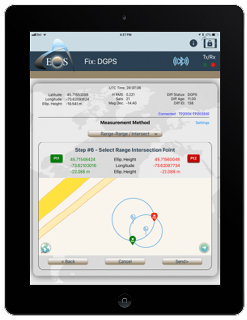
Eos, Laser Technology and Esri Introduce Laser Mapping Workflow for Esri’s Collector for ArcGIS
From left: Esri Program Manager Doug Morgenthaler, Laser Technology Sr. Product Manger Derrick Reish and Eos CTO Jean-Yves Lauture. (Photo: Eos Positioning) The three-way partnership will enable field crews to collect centimeter-accurate 3D data in GNSS-impaired environments.
GNSS receiver maker Eos Positioning Systems has released a laser offset solution within the Esri Collector for ArcGIS workflow.
When combined with Laser Technology Inc.’s (LTI’s) laser rangefinders, the solution will allow field crews to capture centimeter-accurate 3D locations of hard-to-reach assets and in GNSS-impaired environments.
“By combining the high-accuracy of the Eos Arrow Series GNSS receivers and the laser capabilities of LTI, we can empower field crews to capture highly accurate XYZ coordinates from a safe distance,” LTI Senior Product Manager Derrick Reish said. “This eliminates the need for physically occupying every point. It also provides more accurate location data, with a more affordable mobile asset-management workflows.”
The Arrow Gold. (Photo: Eos Positioning) The solution has been in the works for months, as demand has grown for hard-to-reach, high-accuracy mapping within the Collector workflow.
“Eos is extremely grateful to be a part of this initial release in high-accuracy asset location data with LTI’s laser rangefinders and Esri’s Collector mobile app,” Eos CTO Jean-Yves Lauture said. “Enabling this kind of accuracy means even the most budget-conscious field crews will be able to access the location of their hard-to-reach assets.”
All three teams have been working closely to ensure a seamless integration with Collector and ArcGIS Online. When using an LTI laser rangefinder and an Eos Arrow Series receiver with Collector, a field worker can easily shoot, capture and share high-accuracy 3D location data that is streamed into ArcGIS Online in real-time.
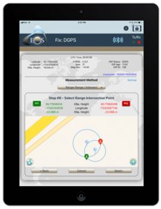
Image: Eos Positioning The solution is expected to be particularly useful in urban corridors, highway settings, forested (or wetlands) areas, and other areas where assets are hard or dangerous to occupy. This will both increase accuracy and efficiency, as well as decrease safety liabilities in dangerous situations, the companies said.
“Esri is extremely pleased that Collector can now support the capture of high-accuracy asset locations from afar, leveraging our unique partnership with both Eos and LTI,” Esri Product Manager Jeff Shaner said. “This is a game changer for asset management.”
Prior to this release, field crews challenged with capturing high-accuracy 3D locations for hard-to-reach assets would need to use a total station with a different software workflow and then mesh the data back in the office, a clumsy and inefficient workflow requiring lots of additional training and expertise. With the new workflow, field crews can operate in GNSS-impaired environments at a high-accuracy level without leaving the Collector/AGOL environment, creating a highly efficient workflow.
The solution has been designed to provide several offset-mapping methods.
“The implementation of several measurement methods gives users the freedom of choice, so they can pick the right laser option which meets their accuracy needs,” Reish said.
Eos will unveil its offset measurement solution for Collector at the upcoming Esri User Conference in San Diego. For a field demonstration of how the solution works, attendees can visit Eos at booth #1019 during the conference, and attend the session “LaserGIS for Everyone: How to Combat Costly and Tedious Data Collection Workflows” at 10 a.m. on Wednesday.
-
Laser Technology showcases laser range finder at Xponential 2018
Laser Technology Inc.’s Clint Cowan offers GPS World a rundown on the company’s laser range finder at Xponential 2018, which took place April 30-May 3 in Denver.
-
Laser Technology highlights TruPoint 200h at Intergeo 2017
Laser Technology’s Nick Ackerson discusses the company’s TruPoint 200h at Intergeo 2017, which took place Sept. 26-28 in Berlin, Germany. According to the company, the TruPoint 200h laser is unique in that it features hybrid measurement technology.
-
Nearmap expert joins Aug. 31 mapping and UAV webinar
Tony Agresta of Nearmap has joined the panel of speakers on the Aug. 31 webinar, “Integrated Technologies for Industrial Positioning.”

Tony Agresta, Nearmap The webinar is free (register here) and focuses on applications in the electric utility/telecom sector, such as site inspections, drones and geographic information systems (GIS) mapping in general. Participants will learn how to maximize reach and capabilities using various sensors and technologies integrated with GPS aboard unmanned autonomous vehicle (UAV) platforms.
Agresta leads the U.S. marketing effort including customer use cases for Nearmap across industries.
Nearmap provides instant access to high resolution aerial imagery including ortho, oblique and now 3D — at scale. Today, this imagery is used for site locate analysis, planning and tracking change over time. The webinar presentation will review the different forms of imagery, how they are captured, managed and delivered in the cloud and used inside ESRI and AutoDesk.
Nearmap provides cloud-based subscription access to up-to-date 2-D orthomosaic aerial imagery. Using its patented HyperCamera2 technology, Nearmap is applying the same access model to the oblique aerial imagery market.

Screen capture from a Nearmap 3D fly-through of Austin, Texas, rendered from Nearmap oblique Imagery. Because this new camera system provides a high degree of overlap from different angles, Nearmap can reconstruct the real world in stunning detail, producing not only high-resolution orthomosaic and oblique imagery, but also surface and terrain models, natural-color point clouds and textured 3-D meshes.
Other Speakers on the Panel

Jeff Fagerman, Lidar USA Jeff Fagerman. Fagerman, a professional surveyor and certified photogrammetrist, is founder and owner of Lidar USA. He holds a master’s degree in photogrammetry from Purdue University. During his tenure with Intergraph from 1985 to 1999, he worked as a photogrammetric software developer on that company’s innovative photogrammetric workstations. In 1999, he started Fagerman Technologies, now known as Lidar USA. In 2010, the main corporate focus became mobile lidar aboard UAVs.
Lidar USA provides solutions for GIS, surveying, civil engineering, agriculture, forensics, BIM, heritage mapping — all things 3D and beyond. In addition to UAV-based mapping and surveying, the company has developed ground—based lidar, building an economical mobile mapping system called ScanLook, incorporating scanning, imaging, and navigation. The company has provided client services in survey/mapping, agriculture, law enforcement, military, archaeology, and education.

Chris Lund, Honeywell Chris Lund, Honeywell Corporation. Lund will focus on inertial sensors as the centerpiece of any robust industrial positioning solution. Given they can’t be interfered with, inertial sensors are the glue that binds the information from all the other sensors together to reveal the desired insights and maximize operator uptime/efficiency.
Lund is a senior director of product marketing for Honeywell’s Navigation and Sensor business. He has experience running product lines for inertial measurement units as well as for surface and marine navigators. Previously, he had engineering roles as a researcher, project lead and technical manager. Lund has an M.S. in the management of technology. He has been working on navigation-related technologies since the late 90s, holds multiple patents, and has co-authored several conference papers and presentations.

Derrick Reish, LTI Derrick Reish, Laser Technology Inc. (LTI). (LTI) started working with the U.S. government more than 30 years ago by designing lasers that measured distances between two planes in-flight for a de-icing exercise. The company then won a contract with NASA to build a custom laser that could measure both distances and speeds for space docking missions. Its first professional measurement device was a hand-held reflector-less total station launched the GPS laser offset sector.
LTI addresses real world needs and applications, including forestry, mining, utilities and surveying, among others. The company focuses on facilitating data collection and GPS/GNSS mapping for professionals, with innovative solutions aboard Android and UAV platforms.
Register here for the free Aug. 31 webinar.
-
Lidar/UAV and inertial experts join panel on free webinar: Integrated tech

Jeff Fagerman, Lidar USA Jeff Fagerman, a professional surveyor and certified photogrammetrist, has joined the panel of speakers on the Aug. 31 webinar, “Integrated Technologies for Industrial Positioning.” The webinar is free (register here) and focuses on applications in the electric utility/telecom sector, such as site inspections, drones and geographic information systems (GIS) mapping in general. Participants will learn how to maximize reach and capabilities using various sensors and technologies integrated with GPS aboard unmanned autonomous vehicle (UAV) platforms.
Also joining the panel for the Aug. 31 webinar is Chris Lund from Honeywell Corporation. He will focus on inertial sensors as the centerpiece of any robust industrial positioning solution. Given they can’t be interfered with, inertial sensors are the glue that binds the information from all the other sensors together to reveal the desired insights and maximize operator uptime/efficiency.
The two new speakers join Derrick Reish of Laser Technology, Inc., for the webinar.
Fagerman is founder and owner of Lidar USA. He holds a Master’s degree in photogrammetry from Purdue University. During his tenure with Intergraph from 1985 to 1999, he worked as a photogrammetric software developer on that company’s innovative photogrammetric workstations. In 1999, he started Fagerman Technologies, now known as Lidar USA. In 2010, the main corporate focus became mobile lidar aboard UAVs.

Chris Lund, Honeywell Chris Lund is a senior director of product marketing for Honeywell’s Navigation and Sensor business. He has experience running product lines for inertial measurement units as well as for surface and marine navigators. Previously, he had engineering roles as a researcher, project lead and technical manager. Lund has an M.S. in the management of technology. He has been working on navigation-related technologies since the late 90s, holds multiple patents, and has co-authored several conference papers and presentations.
Lidar USA provides solutions for GIS, surveying, civil engineering, agriculture, forensics, BIM, heritage mapping — all things 3D and beyond. In addition to UAV-based mapping and surveying, the company has developed ground—based lidar, building an economical mobile mapping system called ScanLook, incorporating scanning, imaging, and navigation. The company has provided client services in survey/mapping, agriculture, law enforcement, military, archaeology, and education.

Derrick Reish, Laser Technology, Inc. Laser Technology Inc. (LTI) started working with the US government more than 30 years ago by designing lasers that measured distances between two planes in-flight for a de-icing exercise. The company then won a contract with NASA to build a custom laser that could measure both distances and speeds for space docking missions. Its first professional measurement device was a hand-held reflector-less total station launched the GPS laser offset sector. LTI addresses real world needs and applications, including forestry, mining, utilities and surveying, among others. The company focuses on facilitating data collection and GPS/GNSS mapping for professionals, with innovative solutions aboard Android and UAV platforms.
Register here for the free August 31 webinar. A final speaker expert in aerial photography will be announced soon.
-
MapSmart app hits the field
Laser Technology’s MapSmart app for Android is a tool for expert field data collection without complicated equipment, the company said.
The software is designed for quick and accurate mapping of anything, including stockpile volumes, with or without GPS coordinates for every data point.
The survey-quality mapping app, using the smart device’s internal GPS or the user’s own external GPS, integrates with LTI TruPulse lasers and enables users to establish an origin and begin capturing field data in minutes.
MapSmart:
- offers four mapping methods to accommodate user preferences
- provides an intuitive interface with icons and buttons
- organizes and classifies data to ease the process of decrypting field measurements in the office
- enables real-time addition of height and missing line values to mapped features
- delivers advanced image capabilities, including tablet photo association with data points and TruPoint 300 image integration
- supports a variety of report formats and wireless data transfer.
The smart features and remote-fire capabilities are especially useful for stockpiles, where users can measure and calculate the volume and tonnage of any material from a safe location.
-
Laser Technology demonstrates laser sensor at Xponential 2017
Laser Technology’s Clint Cowan gives GPS World a rundown on the company’s latest laser sensor, which weighs 2.7 ounces, at AUVSI’s Xponential 2017.
-

Laser Technology offers TruPoint 300 total station

The TruPoint 300 total station by Laser Technology. Laser Technology Inc. (LTI) has released its TruPoint 300 for field data collection and mapping, as well as producing +/–1 millimeter range accuracy. It is a fully integrated laser with vertical and horizontal angle encoders capable of producing 3D, survey-grade measurements.
The TruPoint 300 is LTI’s first phase-technology product with a laser diode that emits light pulses with a distinct wavelength and pulse repetition frequency that obtains millimeter accuracy.
The fully integrated MapStar Angle Technology make the Trupoint 300 suitable for GIS, incident mapping, crush analysis, surveying, electric utilities, architecture and construction.
It will measure the distance between two remote points and has onboard solutions for volume, height, and 2D and 3D area, the company said. Professionals can navigate through measured data, routines, and menus with a full-color touchscreen.
In addition, the laser features an integrated red-dot visual indicator and crosshair with four-power zoom camera, which makes taking measurements easier, especially indoors, LTI said. The unit will also capture a photo of every shot taken that includes raw measurement values and onboard calculations.
Both photos and data can be stored in a CAD-friendly format for professional documentation. With Bluetooth and WLAN, professionals can communicate with apps and transfer X-, Y-, Z-point data files with images.
Several measurement and mapping apps designed by LTI are expected to be released in the coming months. Besides professional-grade lasers for mapping, LTI also provides a line of recreational rangefinders by Bushnell for golfing and hunting.
-
Laser Tech highlights S200 line of sensors at AUVSI’s Xponential 2016
Nick Ackerson, director of global marketing for Laser Technology, shows off the company’s S200 line of sensors at the Association of Unmanned Vehicles International‘s Xponential 2016 show, held May 2-5 in New Orleans. The sensors are used in UAVs for distance measurements and object or collision avoidance.
-
INTERGEO 2015: Laser Technology Unveils TruPoint 300
Eric Miller, president and COO of Laser Technology Inc., introduces the company’s new TruPoint 300 laser measurement product at INTERGEO 2015, which was held Sept. 15-17 in Stuttgart, Germany.
The TruPoint 300 acts as a compact total station. It offers onboard data storage and calculations and includes a small tripod that allows for horizontal and vertical angle measurements. The TruPoint 300 will be available in February 2016, according to Laser Technology.