Laser Technology Inc.’s Clint Cowan offers GPS World a rundown on the company’s laser range finder at Xponential 2018, which took place April 30-May 3 in Denver.
Tag: laser
-
Topcon’s new laser designed for construction projects
 Topcon Positioning Group has added a new laser series to its RL-H line of self-leveling rotating lasers.
The RL-H5 series is designed for high-accuracy and long working range in laser applications for grading, excavating and general construction projects. The new offering includes instruments to support diverse jobsite demands.
Lasers in the series include options in working range of up to 800 meters and up to 100 hours of battery life. The RL-H5A with ±1.5 mm at 30 m horizontal accuracy will be available in the Americas, Europe and Oceania. An additional option, the RL-H5B, with ±3 mm at 30-m horizontal accuracy, will be available in the United States and Oceania.
 “The RL-H5 builds on what Topcon has been bringing to the market for years and pushes the contractor’s productivity capabilities to the next level. It is another example of our commitment to The Intersection of Infrastructure and Technology, the point at which construction productivity can be improved by applying advanced positioning technology,” he said.
The series is covered by the five-year guarantee on Topcon manufactured lasers.
-
High-power microwaves and lasers defeat drones in U.S. Army exercise
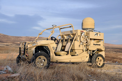
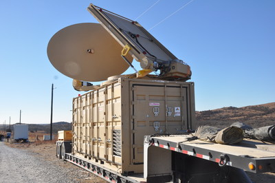
Forty-five unmanned aerial vehicles and drones fell out of the sky during a U.S. Army exercise after Raytheon’s advanced high-power microwave and laser dune buggy engaged and destroyed them.
These common threats were knocked down during a Maneuver Fires Integrated Experiment (MFIX), held in December at the Fires Center of Excellence at Fort Sill, Oklahoma.
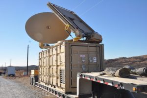
The directed energy system emits an adjustable energy beam that renders drones unable to fly. (Photo: U.S. Army) The directed energy system emits an adjustable energy beam that, when aimed at airborne targets such as drones, renders them unable to fly.
The MFIX event brought military and industry leaders together to demonstrate ways to bridge the Army’s capability gaps in long-range fires and maneuver short-range air defense.
Raytheon’s high-power microwave system engaged multiple UAV swarms, downing 33 drones, two and three at a time.
Raytheon’s high-energy laser, or HEL, system identified, tracked, engaged and killed 12 airborne, maneuvering Class I and II UAVs, and destroyed six stationary mortar projectiles.
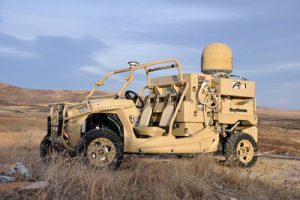
The vehicle-mounted laser is installed on an all-terrain Polaris militarized vehicle. (Photo: U.S. Army) The vehicle-mounted laser combined a solid state laser with an advanced variant of the company’s Multi-Spectral Targeting System and installed them on a small, all-terrain Polaris militarized vehicle.
The system delivers 300 seconds of invisible, precise and instantaneous energy and five hours of intelligence, surveillance and reconnaissance from a single charge, Raytheon said.
Coupled with a generator, the HEL weapon system provides military members with counter-UAV capabilities and a virtually unlimited magazine.
“The speed and low cost per engagement of directed energy is revolutionary in protecting our troops against drones,” said Thomas Bussing, Raytheon Advanced Missile Systems vice president. “We have spent decades perfecting the high-power microwave system, which may soon give our military a significant advantage against this proliferating threat.”
Raytheon and the U.S. Air Force Research Laboratory worked together under a $2 million contract to test and demonstrate high-power microwave, counter-UAV capabilities.
“Our customer needed a solution, and they needed it fast,” said Ben Allison, director of Raytheon’s HEL product line. “So, we took what we’ve learned and combined it with combat-proven components to rapidly deliver a small, self-contained and easily deployed counter-UAV system.”
-
Laser Technology highlights TruPoint 200h at Intergeo 2017
Laser Technology’s Nick Ackerson discusses the company’s TruPoint 200h at Intergeo 2017, which took place Sept. 26-28 in Berlin, Germany. According to the company, the TruPoint 200h laser is unique in that it features hybrid measurement technology.
-
LizardTech granted US patent for lidar point-cloud compression
LizardTech, a provider of software solutions for managing and distributing geospatial content, has been awarded a U.S. patent for the compression of lidar point clouds (US 9753124).
The patented technology provides lossless compression of point clouds captured by airborne lidar sensors or terrestrial laser scanners for easy and cost-effective processing, storage and transmission of data sets.

Point cloud data goes from staggering to manageable when lidar files are compressed to the MrSID format. “Lidar systems capture terabytes of data containing rich information that can be difficult to exploit due to the difficulty processing such massive files,” said John Hayes, the LizardTech senior engineer who received the patent. “Our lidar compression technique allows users to maximize their return on investment in point cloud data collection.”
LizardTech developed the lidar compression technology in 2009 by leveraging the wavelet transformation algorithms used to compress satellite and aerial image data sets into MrSID formats. The point cloud compression technique was first released as a stand-alone LizardTech product called LiDAR Compressor and then integrated into GeoExpress in 2015.
GeoExpress is LizardTech’s flagship software product originally created to enable geospatial professionals to manipulate digital satellite/aerial image and losslessly compress them to industry-standard MrSID or JPEG2000 files. The addition of lidar handling gave GeoExpress the ability to natively compress lidar data to MrSID and LAZ formats with no loss of data content, saving up to 75% on storage, and time in processing files.
Lidar systems are flown extensively on aircraft and unmanned aerial vehicles to collect highly accurate measurements of terrain elevations for a variety of mapping applications.
Another form of lidar, known as terrestrial laser scanning, captures point clouds at ground level — both inside and outside of building structures — for visualization of crime scenes, re-creation of accident sites, and 3D modeling of building interiors.
“Lasers are even being mounted on earth-moving equipment at construction sites for real-time capture of grading progress so that engineering managers can make on-the-spot decisions,” said Toby Martin, vice president of development and strategy at Extensis. “Lidar compression makes this possible and is revolutionizing workflows in the architecture, engineering and construction (AEC) industry.”
The lidar compression algorithms can be licensed via the LizardTech SDK to incorporate the technology into third-party geospatial software solutions. Already, LizardTech is seeing interest in this technology from hardware sensor developers who want to place data compression capabilities at the source of collection.
-
Nearmap expert joins Aug. 31 mapping and UAV webinar
Tony Agresta of Nearmap has joined the panel of speakers on the Aug. 31 webinar, “Integrated Technologies for Industrial Positioning.”

Tony Agresta, Nearmap The webinar is free (register here) and focuses on applications in the electric utility/telecom sector, such as site inspections, drones and geographic information systems (GIS) mapping in general. Participants will learn how to maximize reach and capabilities using various sensors and technologies integrated with GPS aboard unmanned autonomous vehicle (UAV) platforms.
Agresta leads the U.S. marketing effort including customer use cases for Nearmap across industries.
Nearmap provides instant access to high resolution aerial imagery including ortho, oblique and now 3D — at scale. Today, this imagery is used for site locate analysis, planning and tracking change over time. The webinar presentation will review the different forms of imagery, how they are captured, managed and delivered in the cloud and used inside ESRI and AutoDesk.
Nearmap provides cloud-based subscription access to up-to-date 2-D orthomosaic aerial imagery. Using its patented HyperCamera2 technology, Nearmap is applying the same access model to the oblique aerial imagery market.

Screen capture from a Nearmap 3D fly-through of Austin, Texas, rendered from Nearmap oblique Imagery. Because this new camera system provides a high degree of overlap from different angles, Nearmap can reconstruct the real world in stunning detail, producing not only high-resolution orthomosaic and oblique imagery, but also surface and terrain models, natural-color point clouds and textured 3-D meshes.
Other Speakers on the Panel

Jeff Fagerman, Lidar USA Jeff Fagerman. Fagerman, a professional surveyor and certified photogrammetrist, is founder and owner of Lidar USA. He holds a master’s degree in photogrammetry from Purdue University. During his tenure with Intergraph from 1985 to 1999, he worked as a photogrammetric software developer on that company’s innovative photogrammetric workstations. In 1999, he started Fagerman Technologies, now known as Lidar USA. In 2010, the main corporate focus became mobile lidar aboard UAVs.
Lidar USA provides solutions for GIS, surveying, civil engineering, agriculture, forensics, BIM, heritage mapping — all things 3D and beyond. In addition to UAV-based mapping and surveying, the company has developed ground—based lidar, building an economical mobile mapping system called ScanLook, incorporating scanning, imaging, and navigation. The company has provided client services in survey/mapping, agriculture, law enforcement, military, archaeology, and education.

Chris Lund, Honeywell Chris Lund, Honeywell Corporation. Lund will focus on inertial sensors as the centerpiece of any robust industrial positioning solution. Given they can’t be interfered with, inertial sensors are the glue that binds the information from all the other sensors together to reveal the desired insights and maximize operator uptime/efficiency.
Lund is a senior director of product marketing for Honeywell’s Navigation and Sensor business. He has experience running product lines for inertial measurement units as well as for surface and marine navigators. Previously, he had engineering roles as a researcher, project lead and technical manager. Lund has an M.S. in the management of technology. He has been working on navigation-related technologies since the late 90s, holds multiple patents, and has co-authored several conference papers and presentations.

Derrick Reish, LTI Derrick Reish, Laser Technology Inc. (LTI). (LTI) started working with the U.S. government more than 30 years ago by designing lasers that measured distances between two planes in-flight for a de-icing exercise. The company then won a contract with NASA to build a custom laser that could measure both distances and speeds for space docking missions. Its first professional measurement device was a hand-held reflector-less total station launched the GPS laser offset sector.
LTI addresses real world needs and applications, including forestry, mining, utilities and surveying, among others. The company focuses on facilitating data collection and GPS/GNSS mapping for professionals, with innovative solutions aboard Android and UAV platforms.
Register here for the free Aug. 31 webinar.
-
Lidar/UAV and inertial experts join panel on free webinar: Integrated tech

Jeff Fagerman, Lidar USA Jeff Fagerman, a professional surveyor and certified photogrammetrist, has joined the panel of speakers on the Aug. 31 webinar, “Integrated Technologies for Industrial Positioning.” The webinar is free (register here) and focuses on applications in the electric utility/telecom sector, such as site inspections, drones and geographic information systems (GIS) mapping in general. Participants will learn how to maximize reach and capabilities using various sensors and technologies integrated with GPS aboard unmanned autonomous vehicle (UAV) platforms.
Also joining the panel for the Aug. 31 webinar is Chris Lund from Honeywell Corporation. He will focus on inertial sensors as the centerpiece of any robust industrial positioning solution. Given they can’t be interfered with, inertial sensors are the glue that binds the information from all the other sensors together to reveal the desired insights and maximize operator uptime/efficiency.
The two new speakers join Derrick Reish of Laser Technology, Inc., for the webinar.
Fagerman is founder and owner of Lidar USA. He holds a Master’s degree in photogrammetry from Purdue University. During his tenure with Intergraph from 1985 to 1999, he worked as a photogrammetric software developer on that company’s innovative photogrammetric workstations. In 1999, he started Fagerman Technologies, now known as Lidar USA. In 2010, the main corporate focus became mobile lidar aboard UAVs.

Chris Lund, Honeywell Chris Lund is a senior director of product marketing for Honeywell’s Navigation and Sensor business. He has experience running product lines for inertial measurement units as well as for surface and marine navigators. Previously, he had engineering roles as a researcher, project lead and technical manager. Lund has an M.S. in the management of technology. He has been working on navigation-related technologies since the late 90s, holds multiple patents, and has co-authored several conference papers and presentations.
Lidar USA provides solutions for GIS, surveying, civil engineering, agriculture, forensics, BIM, heritage mapping — all things 3D and beyond. In addition to UAV-based mapping and surveying, the company has developed ground—based lidar, building an economical mobile mapping system called ScanLook, incorporating scanning, imaging, and navigation. The company has provided client services in survey/mapping, agriculture, law enforcement, military, archaeology, and education.
Derrick Reish, Laser Technology, Inc. Laser Technology Inc. (LTI) started working with the US government more than 30 years ago by designing lasers that measured distances between two planes in-flight for a de-icing exercise. The company then won a contract with NASA to build a custom laser that could measure both distances and speeds for space docking missions. Its first professional measurement device was a hand-held reflector-less total station launched the GPS laser offset sector. LTI addresses real world needs and applications, including forestry, mining, utilities and surveying, among others. The company focuses on facilitating data collection and GPS/GNSS mapping for professionals, with innovative solutions aboard Android and UAV platforms.
Register here for the free August 31 webinar. A final speaker expert in aerial photography will be announced soon.
-

L3 system selected by Airbus Helicopters for militaries
L3 Technologies’ WESCAM division has received an order from Airbus Helicopters to provide 37 MX-15 electro-optical and infrared (EO/IR) imaging systems for installation on multiple fleets of H225M Caracal helicopters.The systems will be installed in France before being delivered to two foreign governments for military deployment.
“This order expands L3’s international business base while creating a new market opportunity for our leading WESCAM products,” said Michael T. Strianese, L3 chairman and chief executive officer.
“L3 WESCAM is proud to have been chosen to supply its MX-15 systems, as it highlights our role as a trusted global supplier of advanced imaging technologies to the OEM marketplace,” added Mike Greenley, president of L3 WESCAM. “Additionally, it confirms that the highly specialized optics and leading technologies in L3’s systems continue to meet the needs of emerging mission portfolios, ranging from combative military to time-sensitive response and recovery operations.”
The first delivery of 19 units will support a variety of missions, including search and rescue, aeromedical evacuation and assistance and disaster relief.
The second delivery will provide a highly detailed, multispectral view of combat search and rescue, naval operations, medical evacuation and military transportation efforts to mission operators.
L3’s MX-15 can be configured with up to six imaging and laser payloads, each of which shares the highest level of stabilization. It incorporates a GPS receiver and antenna, with options available for a GPS time sync interface and GPS data interface.

Sensor options include a high-definition (HD) thermal imager, color low-light continuous zoom, daylight step zoom spotter, day/night spotter, laser rangefinder and a laser illuminator. L3’s MX-15 can be found on additional models of Airbus helicopters, including the H125 and UH-72A.
L3 WESCAM serves all segments of the airborne, land and maritime markets with advanced EO/IR imaging and targeting systems (MX-Series) and modular system solution kits (MatriX).
MX-Series turrets are operational across 74 countries and on more than 137 different types of platforms, and are supported by more than 14 globally deployed authorized service centers and a team of field service technicians who are available for dispatch 24/7 to anywhere in the world. L3 WESCAM is a unit of L3’s Sensor Systems business segment.