The Federal Aviation Administration on Jan. 16 issued a warning to pilots to “exercise caution” when flying over the Pacific Ocean in parts of Latin America due to potential military activities. Areas cited include the eastern Pacific Ocean near Mexico, Central America and parts of South America.
A series of Notices to Airmen (NOTAMs) issued by the FAA state, “Potential risks exist for aircraft at all altitudes, including during overflight and the arrival and departure phases of flight.” The alerts are in effect for 60 days. NOTAMs are issued routinely in any region where there are hostilities nearby.
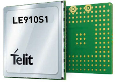
Telit, a global enabler of the internet of things (IoT), has launched the LE910S1-ELG, a new LTE Cat 1 module designed for IoT applications in Latin America (LATAM) that need a combination of performance, affordability, voice support and 2G fallback in a compact form factor.
With an embedded GNSS receiver, the cost-optimized LE910S1-ELG is suitable for tracking applications such as fleet management, stolen-vehicle tracking and recovery, and other mobile IoT applications that need to maintain a reliable connection when moving around in a country, region or multiple regions.
The LE910S1-ELG is the latest member of Telit’s flagship xE910 module family, whose unified form factor and electrical and programming interfaces spanning 2G, 3G and 4G products enables developers to implement a “design once, use anywhere” strategy. The module supports LTE Cat 1 with single-antenna reception, providing downlink speeds of up to 10 Mbps and uplink speeds up to 5 Mbps. Its streamlined configuration, compared to LTE Cat 1 devices with two antennas, helps significantly reduce cost and complexity.
Supporting 2G fallback, the LE910S1-ELG is suitable for applications that require full mobility throughout the LATAM regions, including areas that have not upgraded to 4G yet. It also supports both circuit-switched voice and VoLTE for those applications that require making phone calls, such as healthcare mobile personal emergency response systems (mPERS), connected elevators, alarm systems and more. The power-saving embedded GNSS receiver enables the use of GNSS positioning even when the cellular modem is switched off.
“The LE910S1-ELG is a great option for migrating customers that use legacy 2G and 3G modules in Latin America, especially where nationwide LTE-M and NB-IoT coverage does not yet exist,” said Marco Stracuzzi, head of product marketing, Telit. “Our all-in-one cellular and GNSS module covers all LATAM 4G and 2G bands, as well as mainstream bands used in Europe and Asia, which makes it well-suited particularly for high-performance tracking across intercontinental deployments.”
The LE910S1-ELG is sampling now, and will be commercially available during the first quarter of 2022.
Telit GE310-GNSS IoT Module fills European demand for GSM/GPRS compact form factors, and is part of Telit’s migration-support program that helps customers leverage 2G’s low cost and broad coverage while preparing for 4G and 5G.
The GE310-GNSS module. (Image: Telit)
Telit has released the GE310-GNSS, an internet of things (IoT) module with GSM/GPRS, multi-constellation satellite positioning and Bluetooth functionality in a 270-millimeter-squared form factor.
The GE310-GNSS enables original equipment manufacturers (OEMs) and system integrators in application areas such as asset management, utilities and telematics, meet strong demand for low-cost, highly compact devices without tradeoffs in performance, reliability and functionality, particularly in regional markets such as Europe, where 2G is forecast to remain in strong growth in number of IoT connections for many years.
The GE310-GNSS features a miniature form factor packaged in an LGA 94-round-pad format. It is designed to meet the robust demand in Europe, Latin America and other regional markets for compact devices such as health and wellness monitors, smart residential and commercial thermostats, commercial fleets and IoT-connected grid equipment for smart utilities.
With support for Europe’s Galileo as well as other satellite positioning constellations, the GE310-GNSS is suitable for IoT applications that require location awareness throughout Europe and the rest of the world. The module’s Bluetooth 4.0 capability makes it easy for OEMs to add connectivity to proximal area network devices, Telit said.
The GE310-GNSS is part of Telit’s future-proofing program, which helps customers leverage 2G’s low cost and gapless European coverage immediately while retaining absolute control of when they switch to a compatible 4G module in the Telit family lineup.
The lineup includes multiple roadmap paths to upgrade to 4G and later to 5G based on the customer business strategies and specific market conditions.
Research firm ABI Research estimated in its “ABI IoT Market Tracker – Worldwide – October 2018” that 2G cellular IoT connections will continue to grow in Europe from 100 million in 2018, reaching a peak of 148 million connected devices in 2022 before slowly dropping to about 89 million in 2026.
“The GE310-GNSS is the newest in our lineup of updated 2G modules for markets like Europe and Latin America which still show a sustained pull for over half a decade,” said Yossi Moscovitz, president products and solutions, Telit. “This svelte module combines proven, reliable 2G connectivity with the latest satellite positioning and Bluetooth technologies, all backed by Telit’s decades-enduring migration-support program. Telit has helped thousands of customers through cellular generational transitions and is now helping 2G customers in Europe, Latin America and other regions develop business-enhancing roadmaps to 4G and 5G.”
For more information about the GE310-GNSS and other Telit IoT solutions, visit booth A.b80 at European Utility Week, Nov. 6-8 in Vienna, Austria.
Two weeks ago I helped a colleague with a trade show in Miami called eMerge Americas. This was a general-interest trade show focused on U.S. and Latin American trade and economic development. It wasn’t GEOINT or an ESRI users conference, so I didn’t expect any significant geospatial exhibitors, but I was wrong.
In fact, there were so many geospatial-related displays, I decided to build my column around it — not because there were new developments, but to give you a feel for how business in general is being exposed to and shaped by our geospatial technology.
I found so much visual content that under the “picture is worth a thousand words” philosophy, I shot video clips of exhibitors so that you could quickly hear and see their stories. I discovered a number of true start-up businesses, as well as a large area devoted to showing robotics from local school programs. You may not have the time to view each clip, so the following are brief descriptions of each exhibitor that caught my attention:
Introduction to eMerge Americas
Esri. Because Latin America is a large and growing market, Jack Dangermond had his team there.
Indra. A large Spanish firm demonstrating their end to end solutions including building 3D models overlaid on Google.
Cisco. Cisco had a very large display showing city management of transportation/utilities/ planning using geospatial tools and management systems.
Fish. A company that tracks people and assets using RFID tags and indoor location technology.
Florida International University. FIU had numerous technology displays but their autonomous catamaran doing bathymetry data collection and mapping was impressive.
CartoData. This was a Mexican firm doing some very impressive end-to-end solutions including the use of Pix4D to build 3D models from UAV data.
ImPlaces. A small start-up that builds Smartphone GPS location enabled applications for self guided tours such as museums, parks, real estate, etc.
Baptist Health. Baptist Health demonstrated its 3D remote surgery system that was dimensionally scalable. These systems permit a surgeon to work at a macro level while the surgical tools operate a at microscopic level.
ICONICS. A company that can zoom from a country or regional map down to the detail of an individual valve in a specific plant using CAD/BIM data.
RangeVideo. A UAV company with a very flexible platform and 3D operator viewing goggles.
ALTA Systems. An alternative to powered UAVs.
SnowLizard Products. A small start up building durable waterproof Smartphone cases with Bad Elf GPS and solar panel recharging.
Catbird. A data system security oversight system.
VSN 360. There was a lot of interest in this product. VSN was showing a new 4K HD quality 360-degree video camera a little bigger than a coffee mug with many features. My video of a video didn’t do it justice, so here is a link to the demo video.
For fun, view these non-geospatial exhibitors:
Holography Box USA. A portable, rear projection, point-of-sale video display that looks like a 3D hologram.
TeamSandTastic. A company that provides sand sculptors for trade shows or other events. Doesn’t sound exciting, but just like a Zamboni clearing the ice, you can’t stop watching as an artist turns a pile of sand into a sculpture.
Robotics. Local students show off their robotic construction efforts and operational talents.
Because eMerge has been so well received, I’m happy to see plans are in place to make this an annual event. Latin America is a large and growing market with many talented individuals, some of whom I met at this conference. As a country, we seem to take Latin America for granted, but this a region that shares our values. We need to nurture our relationships and work to prevent the kind of attitudes found in areas hostile to American values.
Topcon Positioning Group is expanding the TopNETlive GNSS reference station network into Latin America. In conjunction with hosting partners, new service will be provided in Mexico, Peru, the Dominican Republic, Bolivia, Guatemala, Colombia and Panama.
TopNETlive is designed to deliver high-accuracy GNSS correction data to rovers for surveying, construction, GIS mapping and agricultural applications.
Partners in the Latin America expansion include TTQ of Monterrey, Geomatic Instruments Corporation, Caribbean Positioning System, Mertind, GYFSA and GeoSystem.
“The growth of the network into Latin America through these strong partnerships clearly demonstrates the Topcon commitment to grow TopNETlive and provide quality service to more positioning professionals globally,” said Jonathan Ball, senior manager for the Topcon network business. “Our hosting partners provide outstanding support, training and service to their customers and the addition of the TopNETlive reference stations will allow them to expand their operations by offering real-time network correction data.”
Topcon dealers will host TopNETlive throughout the various regions, which include: TTQ of Monterrey for Mexico, Geomatic Instruments Corporation in the Peruvian market, Caribbean Positioning System in the Dominican Republic area, Mertind Ltda in Bolivia, GYFSA in Guatemala, and Columbia-based GeoSystem will host the network throughout Colombia and Panama.
Trimble announced today that its high-accuracy, satellite-delivered CenterPoint RTX correction service is now available for farmers in Latin America.
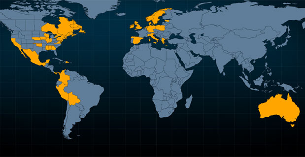
Trimble CenterPoint RTX can deliver better than 3.8-centimeter (1.5-inch) accuracies in real time without the use of traditional reference station RTK infrastructure, the company said. Initially, the CenterPoint RTX satellite-delivered correction service covered approximately a 1.8 billion-acre swath of central North America, extending from Canada into northern Mexico. The new coverage area has been expanded to include all of Mexico, Central America, and South America, where farmers can use the GNSS correction service for cultivating, planting, pest and nutrient management, harvesting and water management.
"The expanded coverage of Trimble's satellite-delivered CenterPoint RTX service into Latin America further extends our broad portfolio of correction services, which also includes OmniSTAR VBS, HP, XP and G2; Trimble CenterPoint VRS; and the CenterPoint RTX service delivered via cellular communications," said Patricia Boothe, general manager of Trimble's Positioning Services Division. "By offering a suite of correction technologies and services, we can satisfy a variety of accuracy, delivery and budget requirements."
"We're committed to expanding the services and software applications that we provide to the global farming community. Increasing the coverage area for high-accuracy GNSS correction services for Trimble's agriculture customers around the world is an example," said Erik Arvesen, vice president of Trimble's Agriculture Division. "In 2011, we offered real-time, satellite-delivered corrections over a central swath of North America where it was well received. Now, farmers in Latin America can also benefit from CenterPoint RTX services to perform precision agriculture operations. Our customers want a broad range of solutions and with CenterPoint RTX, we're delivering those options."
Trimble CenterPoint RTX real-time corrections are satellite delivered directly to the GNSS receiver, so there are no additional costs for mobile data plans or hardware such as radios and antennas. The CenterPoint RTX service is compatible with the Trimble CFX-750 display, FmX integrated display, and the AG-372 GNSS receiver. The service is expected to be available by mid-July. For more information, visit www.trimble.com/agcorrectionservices.


 Two weeks ago I helped a colleague with a trade show in Miami called