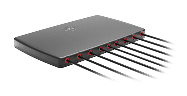
2J Antennas has introduced the Stellar series, antennas designed for a large suite of devices with a focus on GNSS, sub-6 GHz, 5G NR, 4G LTE, 3G, 2G and WiFi-6E technologies.
The Stellar Series is suitable for law enforcement, medical transportation, fire rescue and other applications where mission-critical communication is a requirement. The antennas are designed to reliably provide real-time connectivity in a small size.
This series includes single or up to 9-in-1 configuration choices within the range of 617 MHz to 7125 MHz frequency bands.
The patent-pending technology reduces the antenna footprint by 55% while implementing a new double trifilar design and longitudinal resonances for MIMO/ARRAY configurations that traditionally have more complex size restrictions (such as B71 band/600 MHz).
Each antenna configuration uses symmetrical or asymmetrical resonators for negative sections of the antenna, resulting in maximum performance at low and mid frequencies. The Stellar series offers magnetic and adhesive mounting choices, making them suitable for temporary installations.
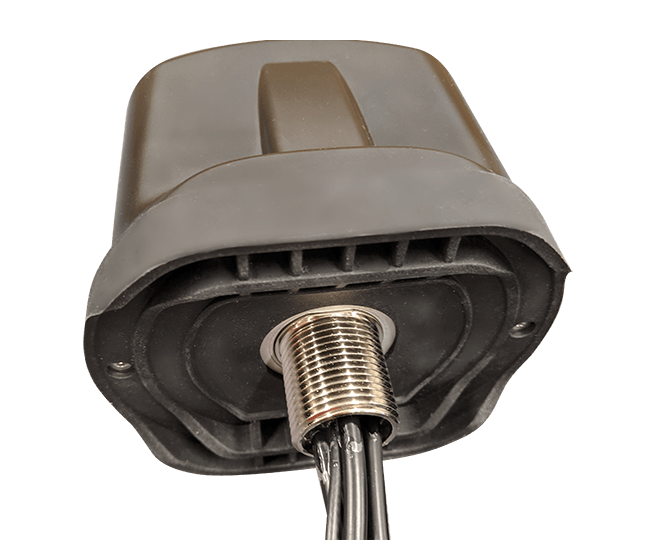
For permanent installation, 2J Antennas also offers the screw mount option in its roof series. The low-profile and lightweight housing introduces a new design that offers a more cost-effective solution for suppliers and distributors.
“We are excited to reinvent antenna designs to meet the fast-growing global markets and offer antenna solutions with the highest quality while reducing antenna sizes as much as possible,” said Ruben Cuadras, director of engineering. “We are proud to continue to bring antenna solutions to customers that require small device integration, reliability and new designs.”
PCTEL has launched its Trooper TRP-20INT platform, featuring models with a purpose-designed footprint to allow seamless installation on the leading 2020 police sports utility vehicles.
Photo: PCTEL
The Trooper TRP-20INT antenna platform supports the high-speed requirements of complex RF communication systems used for critical communications in FirstNet public safety and intelligent transportation systems (ITS).
These antennas feature two 5G elements compatible with leading cellular routers supporting 600-MHz to 6-GHz frequencies. In addition, PCTEL’s proprietary high-rejection multi-GNSS technology is included for high-precision tracking and asset management.
“In order to meet the communication demands of law enforcement, our Trooper TRP-20INT platform was specifically designed for installation on the raised ridges of police vehicle roofs. This method makes installation easier and optimizes RF performance,” said Rishi Bharadwaj, PCTEL’s chief operating officer.
“PCTEL brings strong RF and mechanical design capabilities to develop high-performance antenna systems for deployments in harsh environments in mission critical applications,” added Bharadwaj.
PCTEL also announced its new and improved PCTWSLMR-2 full-spectrum LMR mobile antenna, designed to support the leading OEM multi-band land mobile radios that enable interoperability among emergency management and response personnel. The new antenna incorporates a strong and ultra-flexible spring structure designed for maximum impact shock absorption, providing solid installation integrity even in low overhead-clearance situations.
PCTEL will showcase its new antenna platforms at IWCE, Aug. 24-28, at the Las Vegas Convention Center, Las Vegas, Nevada, booth 1215. Contact PCTEL for more details on product specifications and availability.
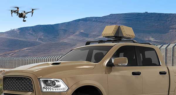
DroneShield has released a vehicle-mounted drone detection and defeat product, DroneSentry-X.
Lightweight at about 10 kilograms, it can be easily mounted on most vehicles. DroneShield expects the product to be of interest to military, law enforcement, security and VIP the markets. The product is suitable for both vehicle/convoy and fixed site installations. The product was developed in response to substantial customer interest, according to the company.
“Vehicle market for counterdrone protection is rapidly rising,” said DroneShield’s CEO Oleg Vornik. “In addition to catering for that segment, DroneSentry-X provides a more affordable detect-and-defeat solution for price-sensitive customers as an alternative to purchasing full-functionality DroneSentry product from us. DroneShield offers a complete suite of detection and defeat solutions to our customers, and this new product covers the customer need which we identified in our recent engagements.”
Law enforcement agencies have been quick to adopt GPS monitoring of offenders on parole or awaiting trial. An estimated 300,000 people in the U.S. are wearing ankle bracelets. Proponents say the systems enhance public safety, reduce prison costs and provide social benefits.
However, technology is only as good as the people who use it, as a tragic case from Ohio illustrates. In February 2017, 21-year-old Reagan Tokes was kidnapped and murdered after leaving work in Columbus. The man convicted of killing her had been recently released from prison. Yes, he was wearing a GPS monitor, but no one was tracking his movements until after he robbed six people and killed Tokes.
In response, Ohio lawmakers introduced a bill to improve real-time monitoring of parolees by shrinking the workload for parole officers, who now are responsible for 90 to 100 offenders at one time.
In cases in Florida and New York, the system worked as intended and alerts were sent, but authorities took no action. In the Florida case, no one was on duty, despite the suspect having triggered more than 100 alarms.
An offender in Syracuse, New York, was able to remove and reassemble his ankle bracelet in less than a minute, using techniques he learned when he watched the officers put the bracelet on him. Because of numerous false alarms, the monitoring company had set a five-minute limit before officers were notified, at the police department’s request. Having beat the monitoring system, the offender committed a murder.
A nationwide investigation by ABC’s “20/20” news magazine program found at least 50 murders allegedly committed since 2012 by people ordered to wear monitored ankle bracelets.
“Public safety is only as good as the supervising entity we provide our products to,” Jennifer White of monitoring company BI Analytics commented on “20/20.” Criminal justice experts say the monitoring system should not be used for anyone who is a risk to the public.
While policymakers and law-enforcement authorities determine the most effective use of such systems —and how to address issues of monitoring response, overtaxed officers and tight budgets — the monitoring industry continues to improve the “tamper-resistant” devices as well as the services offered.
After all, no one wants to live with a false sense of security.
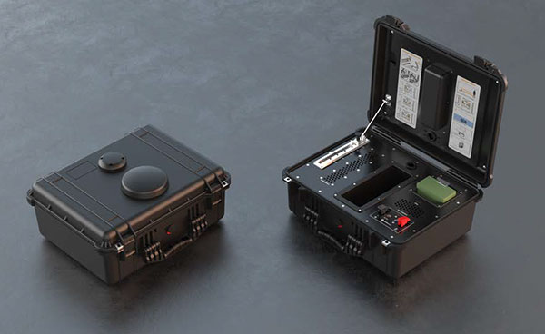
DroneShield has launched DroneNode in response to end-user requirements.
DroneNode is an evolution of the company’s DroneCannon product. It is a portable, compact and inconspicuous counter-drone jamming device that law enforcement can use at large outdoor events without raising public concern.
DroneNode comes in a portable case approximately 50 x 50 centimeters square. It can be set up in seconds and requires very little training to operate, the company said.
It can simultaneously jam 2.4 GHz, 5.8 GHz and GNSS L1 and L2 bands up to one kilometer, causing drones to return to their point of origin or land. DroneNode is also effective against swarm attacks. Emergency broadcasts, cellphone communication and other dedicated channels will not be affected.
According to the company, DroneNode’s covert design makes it a suitable counter-drone solution for public events where protection from drone threats is a priority. Designed within a rugged carry case, DroneNode is easy to transport and is protected from the elements.
DroneNode is powered by a NATO-approved self contained battery with room for a second battery stored in the accessories tray.
“The release of DroneNode continues DroneShield’s leadership in drone security for public events,” said Oleg Vornik, DroneShield’s CEO. “DroneShield’s recent credentials in the area include the 2018 Olympics, the 2018 Commonwealth Games, 2018 ASEAN-Australia Special Summit, the 2017 Hawaii Ironman World Championship, and the 2015 to 2017 Boston Marathons. The company’s products are well positioned to protect large public gatherings globally.”
According to DroneShield, the product is particularly relevant given the recent drone attack on the Venezuelan president and the high-profile mail bomb terrorist attacks in the United States, heightening the awareness of law enforcement globally to potential threats to high-profile political targets.
A Venezuela soldier received head injuries in a the drone attack against the president. (Photo: Released by Xinhua News Agency)
FCC Authorization Pending. DroneNode and DroneCannon have not been authorized as required by the U.S. Federal Communications Commission (FCC). The devices are not, and may not be, offered for sale or lease, or sold or leased, in the United States, other than to the U.S. government and its agencies, until authorization is obtained.
The use of such devices in the United States by other persons or entities, including state or local government agencies, is prohibited by federal law. Laws limiting the availability of such devices of certain types of users may apply in other jurisdictions, and any sales will be conducted only in compliance with the applicable laws.
Nearmap aerial imagery in ArcMap. (Screenshot: Nearmap)
The Shelby County, Tennessee, Emergency Communications District has implemented Nearmap high-resolution aerial imagery to geocode and plot new addresses and developments into its 911 mapping systems.
The mapping systems help fire and rescue, emergency medical services and law enforcement get instant access to updated maps needed to get to the right locations as soon as possible.
The Emergency Communications District is responsible for establishing local emergency telephone service, providing the network call-handling equipment, and updating the geographic information systems (GIS) data for each Public Safety Answering Point within Shelby County.
Nearmap provides frequently updated, high-quality aerial captures to ensure that the district’s GIS data, geocoding and the 911 mapping systems are up to date, providing public safety and law enforcement the most accurate information, the company said.
Benefits of Nearmap aerial imagery for the Emergency Communications District include:
The imagery is delivered through the cloud as a subscription service, making it accessible to all team members via mobile and desktop.
Nearmap imagery is taken at least twice a year, both leaf-on and leaf-off to provide different views of locations in different seasons.
Aerial captures integrate directly into Esri ArcMap, ArcPro and ArcGIS Online applications, so GIS information can overlay directly onto the high-resolution imagery.
Before Nearmap, Shelby County’s aerial image process required a contracted flight to photograph the county areas. Because of the high cost of capturing those images, the county purchased images once every two years, after pooling resources from various county entities.
“With our old aerial imagery provider, there were issues with mosaicking separate images together, and since the imagery was taken every two years, many rural and unincorporated areas were out of date,” said Timothy Zimmer, GIS administrator for Shelby County’s Emergency Communications District.
With out of date images, the county had to develop alternate methods to locate addresses for the 911 systems. Now, the combined impact of data services, base maps, Nearmap imagery and third-party data are improving all aspects of public safety, including law enforcement, fire and emergency medical services, Nearmap said. Even other agencies are using the district’s imagery and GIS data.
“There’s a certain context and currency you can get from Nearmap imagery that you simply can’t get from any other imagery products,” Zimmer said. “Other agencies, such as the County Clerk and the Utility Company, are using our addressing data because Nearmap has helped enable us to be much more current.”
As Hurricane Florence rattles along the coastlines of the Carolinas and Georgia creating havoc, everything that flies is grounded. Right now the hurricane has slowed to a tropical storm, but flooding is extensive and people have died.
As soon as the high winds subside, expect almost all first response groups to put up UAVs to begin damage assessment. Digital images gathered by these drones will assist forward personnel to direct recovery and rescue operations. FEMA and other search and rescue teams, already in place along the track of the storm, have begun to rescue people by boat and are expected to fly drones over other inaccessible areas to find survivors.
And, of course, a significant part of the coverage we will see over the next week or so will come from drone-borne TV cameras and links to network uplink vans. We should also expect drones to be used for significant data gathering to map affected areas for damage to homes and infrastructure — including powerlines, radio and cellphone towers and distribution centers, waterways, roads and railways.
Let’s hope that the lessons learned and experience gathered during the major storms of last year will help everyone operating drones assist in minimizing the time to rescue people and to speed recovery from this latest hurricane. Later, expect the insurance companies to arrive with UAVs to assess damage and verify claims.
Police forces are using drones…
The law enforcement office in Dauphin County, Pennsylvania, has been using a drone for several months. With more than 13 investigations completed, the drone has helped locate one lost individual and has also supported crime-fighting.
Rather than calling out a manned helicopter for assistance, the police are able to get a drone in the air within 20 minutes at much less cost.
FAA regulations govern how Dauphin County law enforcement officials fly their drone, including a waiver granted to allow night-time operations.
…while Colombia is testing drones to destroy coca plants.
Recent growth in Colombian coca cultivation to 516,000 acres during 2012-2017 came as a consequence of the end of a government program to fumigate coca fields. Crop-duster planes spraying glyphosate had previously reduced Colombia’s coca fields from 470,000 to 193,000 acres during 2001-2012, according to U.S. figures.
Meanwhile, U.S overdose deaths from cocaine are continuing to increase, while rebels and drug traffickers have apparently shot down several crop-dusters.
Lawsuits against the use of the chemical glyphosate have also been successful. Over-spray is alleged to have killed other, legal crops, and opponents also cited a recent ruling in California that awarded $289 million in damages to a groundskeeper who said glyphosate-based weed killers had caused his non-Hodgkin lymphoma.
Because of concerns, Columbian police have been testing drones — flying a couple of feet above the plants to mitigate over-spraying of defoliants — to kill coca crops and reduce the supply of cocaine. Apparently, 10 remotely guided drones, each weighing 50 pounds fully loaded, destroyed hundreds of acres of coca in the first phase of tests. Though common in agriculture for the monitoring of crop growth, it’s thought that drones have never before been used to kill illegal crops. The fumigation appears to be about 90% effective to date.
Nevertheless, in Colombia’s drug zones, soldiers will be needed to partition swaths of coca-producing land and to defend operators from angry farmers and drug traffickers. There are also land mines which will need to be overcome from Colombia’s long rebel conflict and which pose a danger to drone operators.
Counter UAS (C-UAS) systems are on the rise.
The Drone Dome system uses Laser, RF and Radar. (Photo: Rafael)
As fast as drone technology is developing, counter UAS (C-UAS) systems are also being put in place to prevent unwanted drones from penetrating the air above sensitive facilities — by detecting and disabling them. There are purportedly more than 60 such C-UAS systems available in the U.S., with more in other countries including China and Russia.
Systems use various technologies for detection — such as radar, laser, optical/IR, RF “sniffer,” and acoustic. Drones can be disabled by RF and GNSS jammers, by spoofing of both the GNSS navigation or the control link, and can be brought down physically by high-power lasers, nets deployed by other drones, collisions by attack drones, by regular or specialized anti-drone gun systems and even by high-pressure water cannons for very close-in defense. Anti-drone systems include detection and take-down dome-based systems and man-portable drone guns.
SpotterRF C-UAV radar. (Photo: UAS Vision)
The UK government has acquired the Drone Dome C-UAS (counter-UAS), manufactured by Rafael, Israel. Detection is provided by an S-band radar (four radars provide all-round coverage), an electro-optical/infrared (EO/IR) surveillance suite, and a wideband RF sensor.
Drones can be disabled by a high-power laser, an RF jammer, or when very close-in by a high-pressure water gun. The UK system is expected to use jamming to bring down drones and doesn’t include the high power “hard-kill” laser option.
Depending on the size of the intruder drone, the radar detection range is around 3.5-10 kilometers, and the radar may also disable a UAV when integrated with the RF jammer. With an active electronically scanned array antenna, the radar is relatively small and light-weight for both fixed and mobile installations.
The DroneGun. (Photo: DroneShield)
Another C-UAV offering, from SpotterRF, claims to solve the problem of requiring multiple radar elements to achieve 360-degree “dome” coverage. The 3D-500 radar enables full “dome-drone” detection from 0 to 90 degrees vertical and 360 degrees horizontal using a single radar with a 500-meter detection radius, yet weighs only 12 pounds.
Latitude, longitude and altitude of intruder targets are measured within a 1-kilometer diameter hemisphere dome. Following radar detection of an unauthorized drone, the system may be augmented by a slew-to-cue optical/IR camera providing a visual display to an operator — a directional RF jammer on a pan/tilt turret can then be activated to take-down the intruder. The system operates automatically to both detect and disable the drone, or manual control is possible to enable initial operator confirmation of the target before take-down is activated.
DroneShield out of Australia markets a drone detection and mitigation system probably best known for its DroneGun. The DroneGun is a point and shoot device able to disrupt multiple RF frequency bands simultaneously (433 MHz, 915 MHz, 2.4 GHz and 5.8 GHz), taking out the communication link to a drone operator — and also GNSS signals when so equipped — up to 1 kilometer away.
The full DroneSentry detection system integrates a suite of sensors and countermeasures including radar, optical, RF listening, acoustic, thermal and an RF countermeasure transmitter with greater power and range than the portable DroneGun.
Another example is the Rex-1 drone gun. Operating in the 2.4 GHz and 5.8 GHz bands, the Rex-1 rifle-like drone-disabling device is a man-portable jammer developed by Russian Kalashnikov Group subsidiary ZALA Aero Group.
https://youtu.be/Px56KtpZ004
Mapping and survey are becoming a major application for drones.
One such example is 3D mapping of a copper mine in only three days using a fixed-wing UAS.
At an altitude of 1,400 meters, the Erdenet open-pit mine in Mongolia extends 5 x 2 kilometers and is more than 200 meters deep in places. Despite strong winds and even some snow in May this year, one UAS quickly captured geospatial data that enabled three-dimensional modeling of the large, complex site.
Site management is expected to use this initial model as a baseline against which future drone-maps will be compared, and to plan future mine operations.
However, extensive preparations over a two-week period were still required, including the installation of 21 ground control points, positioned using GPS RTK measurements. Re-verification of these points was also required from time to time before the survey, due to changes in the mine from ongoing mine operations, including dynamite blasting.
A MAVinci Sirius UAV was used to gather almost 7,000 aerial photographs which were processed through Agrisoft Photoscan Pro software to produce a detailed digital surface model. All the data collected will be used to create various internal views of the mine for continued mining operations. The mine produces about 26 million tons of ore each year, leading to approximately 530,000 tons of copper and 4,500 tons of molybdenum derivatives.
UAVs make medical deliveries.
Some U.S. medical facilities will soon be participating in a Department of Transportation test program to transport medical samples and supplies by UAV — the object being to obtain test results and medical supplies much quicker than at present. Matternet, Zipline and Flytrex — UAV companies already involved in deliveries by drone — will use several different UAVs in the program, which also aims to set up a number of medical distribution centers.
Matternet has been delivering medical supplies by drone in Switzerland, and Flytrex is focusing on food and package deliveries.
Delivery drone in Kasungu, Malawi. (Photo: AFP)
Meanwhile, Zipline and UNICEF have established an “air corridor” in the city of Kasungu in Malawi to test the transport of medical supplies by drone. Rwanda had previously used UAVs to deliver medication in Africa. Other underdeveloped countries without good ground infrastructure could well benefit by using life-saving drone deliveries for urgently needed medication.
Supporting police investigations, mapping of mines, and coca crop destruction all seem to be good examples of newer uses for unmanned air vehicles. And when policing of drone intrusion is required, looks like there are many new options to detect, disable and even take down unwanted drones. I’d say we seem to be making good progress towards better acceptance and that the industry is starting to grow up.
And let’s all hope that the efforts of all first responders in the Carolinas and Georgia continue through the many weeks of recovery from flooding and damage that are still to come, and that people can soon get back into their homes.
The U.S. Supreme Court ruled June 22 that the government needs a warrant to access a person’s cellphone location history.
In the case Carpenter v. United States, the American Civil Liberties Union represented a man who had months of his cellphone location information turned over to law enforcement without a warrant. Investigators received the cell tower records with a court order that requires a lower standard than the “probable cause” needed to obtain a warrant.
The court found in a 5-to-4 decision that obtaining such information is a search under the Fourth Amendment and that a warrant from a judge based on probable cause is required.
“This is a groundbreaking victory for Americans’ privacy rights in the digital age,” said ACLU attorney Nathan Freed Wessler, who argued the case before the court last November. “The Supreme Court has given privacy law an update that it has badly needed for many years, finally bringing it in line with the realities of modern life.
“The government can no longer claim that the mere act of using technology eliminates the Fourth Amendment’s protections. Today’s decision rightly recognizes the need to protect the highly sensitive location data from our cell phones, but it also provides a path forward for safeguarding other sensitive digital information in future cases — from our emails, smart home appliances, and technology that is yet to be invented.”
Case background
In 2011, without getting a probable cause warrant, the government obtained from cell service companies months’ worth of phone location records for suspects in a robbery investigation in Detroit. For one suspect, Timothy Carpenter, the records covered 127 days and revealed 12,898 separate points of location data. Police seek these kinds of cellphone location records from phone companies tens of thousands of times each year.
After Carpenter was convicted at trial, based in part on the cellphone location evidence, he appealed to the Sixth Circuit Court of Appeals, which ruled 2–1 that no warrant is required under the Fourth Amendment.
The Supreme Court said in its opinion today, “We decline to grant the state unrestricted access to a wireless carrier’s database of physical location information. In light of the deeply revealing nature of CSLI, its depth, breadth and comprehensive reach, and the inescapable and automatic nature of its collection, the fact that such information is gathered by a third party does not make it any less deserving of Fourth Amendment protection. The government’s acquisition of the cell-site records here was a search under that amendment.”
Tech companies and media weigh in
Among the many friend-of-the-court briefs filed in the case is the one from technology companies, which was signed by Google, Facebook, Apple, Verizon, Twitter, Cisco, Microsoft and others. They echoed the ACLU’s arguments, writing that “Fourth Amendment doctrine must adapt to the changing realities of the digital era” and that “Rigid analog-era rules should yield to consideration of reasonable expectations of privacy in the digital age.”
In another friend-of-the-court brief, the Reporters Committee for Freedom of the Press and 19 other media organizations warned of the chilling effect on First Amendment freedoms that can result from easy law enforcement access to the location information of reporters and their sources.
Third-party doctrine
The government’s argument was based on the “third-party doctrine,” which the government reads to provide that by sharing information or records with a “third party” such as a business, a person gives up any reasonable expectation that the information will remain private. The doctrine was established in Supreme Court cases from the 1970s, which reasoned that without an expectation of privacy, there is no Fourth Amendment protection for certain records voluntarily shared with businesses, such as canceled checks sent to a bank or phone numbers dialed on a phone and transmitted over a phone company’s equipment. The government has extended that principle to cover various kinds of digital records, such as cell phone location data.
“The court’s decision is a vindication of the arguments we have persistently made on behalf of Timothy Carpenter throughout this litigation — that the Constitution’s privacy protections fully apply to the digital location data created by using cell phones,” said attorney Harold Gurewitz, who represents Carpenter alongside the ACLU. “The ruling also affirms that prosecutors are required to get a search warrant in order to seize this kind of sensitive personal information.”
The data acquired by police in the case provides a stark demonstration of how location data can reveal extraordinarily private details about people’s lives, from where they sleep to where they pray.
For example, the location data showed that in the early afternoon on a number of Sundays, Carpenter made or received calls from the cell tower sectors nearest to his church. His cellphone records do not routinely show him in that area on other days of the week, implying that he was worshipping at those times. The data also shows which nights he slept at or near his home, and which nights he spent elsewhere.
Carpenter is represented at the Supreme Court by the ACLU, the ACLU of Michigan, defense attorney Gurewitz of Gurewitz & Raben PLC, and Jeffrey Fisher, co-director of the Stanford Law School Supreme Court Litigation Clinic.
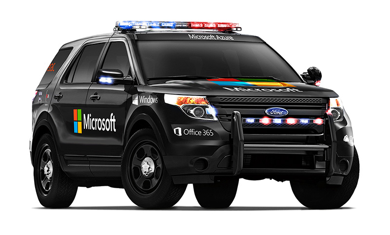
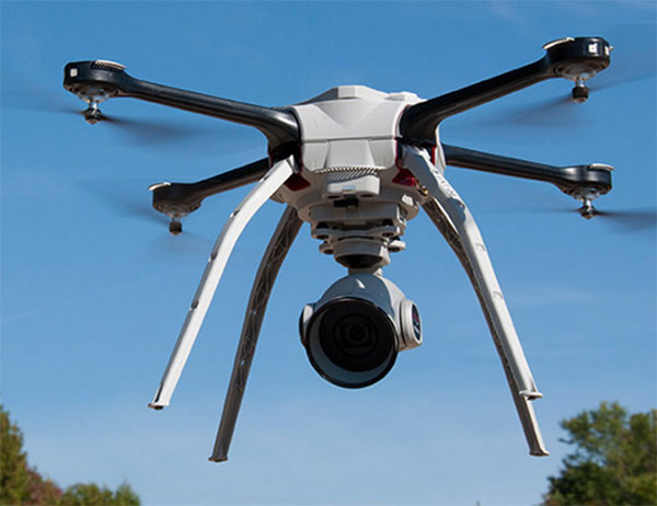
Aeryon Labs is partnering with Microsoft on its new Microsoft Advanced Patrol Platform (MAPP) vehicle. Microsoft has chosen Aeryon’s SkyRanger UAV to demonstrate aerial image and data capture for MAPP.
Aeryon Labs is a provider of small Unmanned Aerial Systems (sUAS) for military, public safety and commercial operators worldwide.
“Law enforcement organizations throughout the world rely on Aeryon sUAS to collect aerial intelligence wherever and whenever they need it,” said Dave Kroetsch, president and CEO of Aeryon Labs Inc. “Including SkyRanger within the MAPP vehicle rounds out the comprehensive suite of technologies and highlights the value of aerial intelligence for ground-based personnel.”
Aeryon Labs’ SkyRanger UAV provides real-time intelligence to law enforcement. (Photo: Aeryon Labs Inc.)
MAPP will connect its drivers to helpful and easy-to-navigate information, Aeryon said. Currently, patrol officers spend vast amounts of valuable time bound to their cars, clicking between windows on bulky, often dated laptops. MAPP will consolidate the many elements officers must keep track of — providing dispatch information, driving directions, suspect history, a voice activated license plate reader, a missing persons list, location-based crime bulletins and statistics, a feed of shift reports and more.
For first responders, surveillance teams and investigators, high-quality aerial imagery provides the real-time intelligence needed to assess a situation immediately, ensure safety on the ground, and capture detailed evidence and forensics. By integrating aerial images from Aeryon sUAS with other cutting-edge hardware and software solutions, the MAPP program sets a new technological standard in policing and helps officers operate with better awareness, efficiency, mobility and safety.
Aeryon Labs is showcasing the integrated solution at the IACP 2015 law enforcement and public safety conference, being held Oct. 25-27 in Chicago.
American Sentinel University’s new e-book, GIS for Crime Analysis, Law Enforcement and Public Safety, profiles how GIS has become an effective new crime-fighting tool used by law enforcement agencies to uncover criminal patterns that would be otherwise impossible to identify. The complimentary e-book is available for download.
GIS technology merges and manages massive amounts of law enforcement data into geodatabases that instantly analyze, map and aggregate data and provide law enforcement agencies with actionable intelligence to fight crime.
Senior Cpl. D.J. Beaty, police GIS and geospatial analyst for the Dallas Police Department, is featured in the e-book and shares insight about how his use of GIS and geospatial analysis has improved the ability to fight crime to ensure public safety.
“Crime is not uniformly distributed and identifying high crime areas or hot spots is significant for strategic and tactical approaches for law enforcement agencies,” says Sr. Cpl. Beaty. “New situations require new strategies and solutions. GIS analysis helps law enforcement agencies prioritize and allocate resources to targeted areas to address specific criminal activity. By implementing a geographic approach to analyze crime, the Dallas Police Department can efficiently and effectively meet the challenge of reducing crime in our community.”
The advanced spatial analysis of crime data continues to change the ways in which modern policing occurs. GIS provides the geographic advantage for law enforcement agencies to combat crime by using computers, analysis and programming skills to make predictions based on proprietary algorithms.
GIS for Crime Analysis, Law Enforcement and Public Safety is aimed at law enforcement professionals whose organization or company plans to implement new or enhance existing GIS technology. The e-book provides valuable insight about why GIS is on forefront of cutting-edge technology, the Dallas Police Department’s successful use of GIS to combat crime and offers a guide for law enforcement professionals to enhance their educational and professional goals.
Topics include:
Technology and Its Application
Types of Users
Training and Background
“As more law enforcement agencies embrace GIS, overall public safety can be enhanced through better crime prevention strategies, improved response times, interagency data sharing, cooperation and collaboration to ultimately see reduced crime rates through the community,” says Stephen A. McElroy, Ph.D., GIS program chair at American Sentinel University. “GIS has opened a world of new tools for law enforcement and given practitioners in the field a way to advance their careers while making a significant contribution to public safety and order.”