Tbe company has received Global Certification Forum validation of 5G LBS Assisted-Galileo test case
Keysight Technologies Inc. has gained Global Certification Forum (GCF) validation of a 5G location-based services (LBS) assisted-Galileo (A-Galileo) test case by combining 5G new radio (NR) and GNSS technology.
The achievement will accelerate implementation of LBS in smartphones by enabling mobile phone vendors to verify that designs comply to the latest 3GPP specifications that support accurate location positioning in a wide range of sectors.
Sectors include healthcare, road and aerial transportation, emergency and rescue services, public safety, and homeland security. Highly precise positioning services also enable mobile operators to deliver personalized services supporting entertainment, hospitality and retail applications.
LBS leverages different technologies, including GNSS, beamforming and round-trip time to geographically locate a user. LBS test cases allow users to verify sensitivity, accuracy and dynamic range in mobile phones that leverage GNSS constellations to identify precise geographic location.
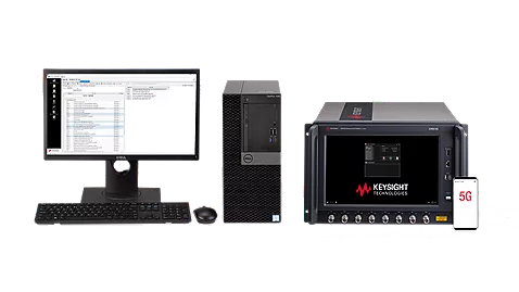
S8705A RF/RRM DVT and Conformance Toolset. (Photo: Keysight)
GCF conformance agreement group meeting #72, held Oct. 21, confirmed the validation of the first 5G LBS A-Galileo test case, which was supported by Keysight’s S8705A RF/RRM DVT and Conformance Toolset. The toolset provides access to a wide range of radio frequency, radio resource management, and development validation test cases used to verify 5G NR designs in both non-standalone and standalone deployment modes.
The S8705A toolset uses the E7515B UXM 5G Wireless Test Platform, a compact signaling test platform with multi-format stack support, rich processing power and abundant RF resources for emulating various mobility scenarios in a 5G network as well as a recommended GNSS emulator to deliver the LBS test case.
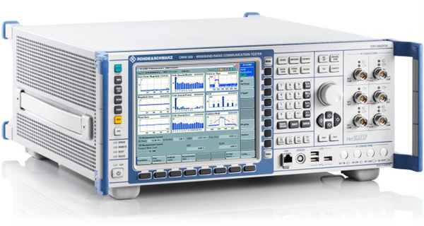
Rohde & Schwarz and MediaTek have verified new location-based services (LBS) features for 5G new radio (NR), which are now available on the R&S TS-LBS test solution.
The features will improve emergency caller location and support LBS-related use cases in challenging indoor and outdoor environments with both satellite-based and terrestrial technologies. The R&S TS-LBS now support these and other 3GPP Release 16 network-based positioning features.
A 5G chipset from MediaTek also has been verified for Release 16, which ensures the chip’s positioning features.
The two companies verified the NR positioning reference signals (NR-PRS), which are central to network-based positioning features such as round-trip time (RTT), time difference of arrival in uplink and downlink (UL- TDOA and DL-TDOA), or angle of arrival and departure (AoA and AoD), and which meet the 5G requirements for indoor and outdoor positioning use cases.
With R&S TS-LBS supporting these features, mobile device and chipset manufacturers as well as test houses and network operators can carry out verification for GCF, PTCRB and network-operator certification using a single test solution.
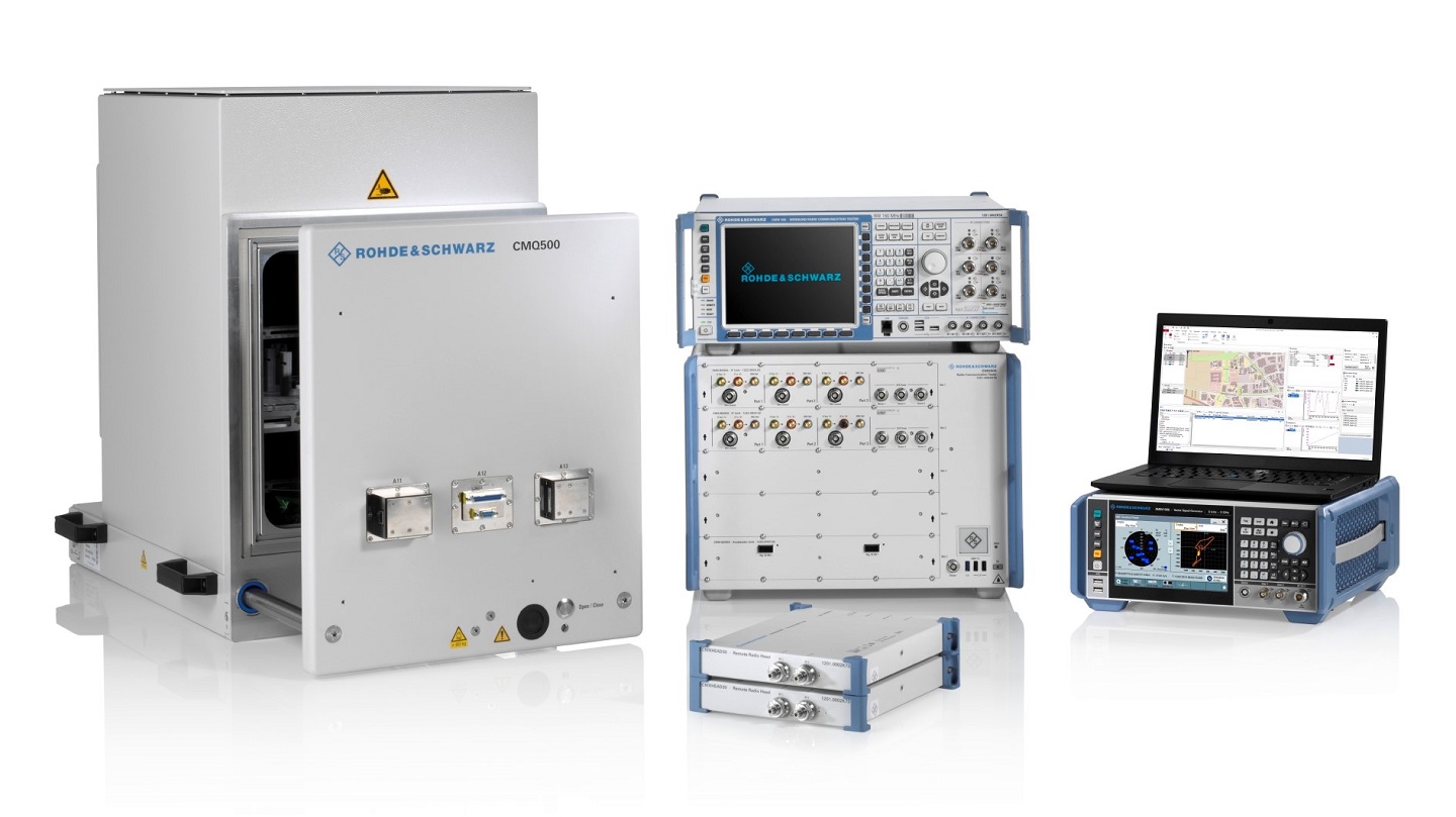
About the R&S TS-LBS System
The R&S TS-LBS is a test system for testing GNSS and network-based positioning. It consists of an R&S CMX500 OBT one-box signaling tester as the network simulator and an R&S SMBV100B GNSS simulator.
The R&S CMX500 OBT setup provides full network simulation capabilities including the support of multiple 4G or 5G cells at a time. In addition, it provides LBS assistance data to the DUT while the R&S SMBV100B simulates the GNSS satellites.
The R&S TS-LBS test system can be used for pre-conformance tests and to obtain GCF and PTCRB certification as well as network-operator-specific certification acceptance and validated tests.
“Adding network-based positioning features such as DL-TDOA based on NR-PRS to the existing satellite based location signals shows the advanced level of our test solution,” said Christoph Pointner, senior vice president, Mobile Radio Testers, Rohde & Schwarz. “We are happy to continue our collaboration with MediaTek to push 5G location-based services further for 3GPP Release 16.”
Rohde & Schwarz supports 5G LBS with assisted GPS and 5G NR FR2 mmW performance testing
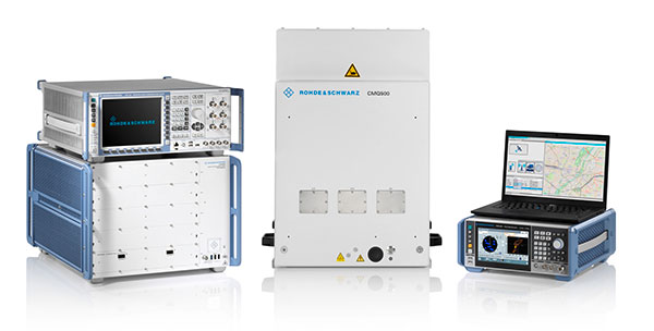
Photo: Rohde & Schwarz
Simulator and test company Rohde & Schwarz has verified assisted GPS (AGPS) performance in a commercial mobile device, while simultaneously transferring data using 5G millimeter wave (mmW). This capability is now available with the Rohde & Schwarz TS-LBS (location-based services) test system.
As wireless network operators roll out 5G NR in the millimeter wave spectrum, it is critical to ensure continued reliability of E911 calls and accurate determination of location in mobile devices.
5G NR utilizes frequencies in the FR1 frequency range (<7.125GHz) and in the FR2 mmW frequency range (>24GHz). FR2 creates unique challenges for mobile devices in terms of power consumption and heat. With FR2 becoming more common in North American mobile devices, performance of critical services such as E911 emergency calls cannot be allowed to degrade when utilizing this mmW spectrum.
When used together in the TS-LBS test system, the R&S CMX500 radio communication tester and R&S CMW500 wideband radio communication tester provide a seamless and comprehensive test platform capable of testing LTE, 5G NR FR1 and FR2, while the R&S SMBV100B vector signal generator simulates the GPS L1 & L5, GALILEO, GLONASS & BEIDOU satellite constellations for A-GNSS.
Other positioning technologies that use barometric pressure sensors, Wi-Fi and/or Bluetooth are also available in the same solution. Legacy technologies such as GSM, WCDMA and LTE are all supported using the same hardware.
“The addition of FR2 mmW to our TS-LBS test solution gives customers the latest capabilities needed to continue certifying their mobile devices to evolving 5G standards,” said Bryan Helmick, Rohde & Schwarz. “Customers can easily add 5G to existing LTE TS-LBS systems with the simple addition of an R&S CMX500. FR2 support only requires some hardware on the R&S CMX500 and an R&S CMQ500 mmW shield cube.”
5G NR in the sub 6 GHz frequency range (FR1) can be seen as a natural evolution of LTE to achieve higher bandwidth and more flexibility on the physical layer in order to realize all the new and additional use cases defined for a next-generation mobile network.
The real technical challenge, however, comes with 5G mmWave (FR2), which opens up a new level of complexity in device development. mmWave frequencies imply measurement challenges that call for new testing approaches.
The European GNSS Agency (GSA) has launched the MyGalileoSolution competition. The contest is targeting European innovators and entrepreneurs ready to develop location-based solutions, such as mobile applications, wearable-based solutions, asset management and tracking solutions, or robotics, leveraging Galileo as a source of positioning, navigation and/or timing. A wide participation from all Member States is expected.
GSA has a successful track record in supporting and boosting GNSS-based innovative applications. For years, the agency has been leading several research and innovation initiatives such as the Galileo Masters, Horizon 2020 projects, and more recently European competitions like the 2019 MyGalileoApp and Hackathons across Europe and beyond.
Two tracks for 56 prizes
With a prize pool of almost € 1.5 million, MyGalileoSolution is the largest competition ever organized by the GSA. It consists of two independent and parallel tracks, each one with a list of goals and deliverables.
Track 1 , From Idea to Prototype, aims to develop a beta version of an application or a prototype of a solution implementing an idea, reaching a minimum of 50% of its functionality.
Track 2, From Prototype to Product, aims to develop a fully functional solution ready to be commercialised starting from a beta version of an application or a prototype.
Participants are expected to leverage Galileo’s robust positioning and accurate timing and synchronization capabilities, showing how it can enable the development of the next generation of applications and services across a wide range of areas. In this competition the GSA is challenging innovators in four different areas: Crisis & Emergency Response, Smart Transport for Green Deal, Solution for Digital Age, and Cybersecurity.
Galileo for location-based services
With more than 1.5 billion Galileo-enabled smartphones and more than 51 million GNSS-enabled wearable devices in the market, location-based services (LBS) are booming. Accurate positioning and timing are at the heart of the growth and evolution of LBS, in addition the access to Android GNSS raw measurements has allowed for the creation of advanced GNSS positioning algorithms that enable the development of more ambitious smartphone-based applications.
‘’Galileo has set the trend for dual-frequency chipsets, which provide better accuracy and are more resistant to multipath in urban environments,” said Pascal Claudel, GSA acting executive director. “We are looking forward to seeing innovators launching their disruptive GNSS solutions and turning them into real businesses, hence leading to European growth, competitiveness and sustainability. There is ‘space’ for all types of innovation and we expect the participation of all Member States.”
“Competitions like MyGalileoSolution are a great opportunity to quickly move from idea to market,” said Francesco Fiorito, leader of Argeo, the winning team of the 2019 MyGalileoApp competition. “It is a confidence boost for young entrepreneurs and their capacity to grow and generate new solutions and business,” Claudel concluded.
Deadlines and more information
The deadline for submission for both categories is Sept. 30. Projects will be evaluated in terms of their innovative nature, market potential, feasibility and Galileo relevance by a panel of GSA experts.
Woolpert has received the 2019 Google Cloud Specialization Partner of the Year award for location-based services.
Woolpert was recognized for the company’s achievements in the Google Cloud ecosystem, helping joint customers deploy and optimize their location-based services, developing an online customer assistance system and cloud information portal, more than doubling its staff to support customer needs and supporting all location-based data efforts with its extended geospatial team.
The firm, which has been a Google Cloud Partner since 2015, was awarded this honor and the Google Cloud Partner Award for Customer Success in Google Maps Platform in 2018. Woolpert Vice President and Chief Innovation Officer Jon Downey said Woolpert is honored to work with Google Cloud and provide a heightened level of products and services to the teams’ joint customers.
“We thought this would be a natural partnership, joining the world leader in customer-facing location-based services with one of the first global geospatial mapping firms, but it has far exceeded our expectations,” Downey said. “It has given us the ability to create products and provide support specific to our clients’ location-based needs, which has led to a greater than 98% retention rate and more than 100 additional customers in 2019. We look forward to what this partnership will yield in the future.”
“We’re proud to recognize Woolpert’s work on behalf of customers,” said Carolee Gearhart, vice president, Worldwide Channel Sales at Google Cloud. “Woolpert has demonstrated strong expertise and results in providing location-based services for customers over the past year, and we look forward to continuing our partnership to help customers succeed.”
Testing the antenna performance of GNSS signals such as GPS, GLONASS, Beidou, Galileo and Metropolitan Beacon Systems (MBS) is key to location accuracy performance of a mobile device.
To address the testing need for A-GNSS services, Rohde & Schwarz and Bluetest are partnering in creating test concepts for over-the-air (OTA) antenna measurements.
The CMW500 wideband radio communication tester. (Photo: Rohde & Schwarz)
The two companies integrate the R&S LBS Server, a software component running on the R&S CMW500 wideband radio communication tester, and the Bluetest OTA test solution for A-GNSS systems based on Bluetest’s RTS65 reverberation chamber and Bluetest’s Flow measurement software.
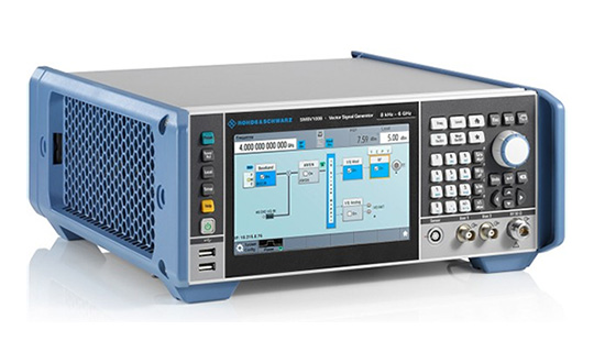
In the test setup, the R&S LBS Server controls the Rohde & Schwarz base-station simulator R&S CMW500 for LTE, WCDMA and GSM, and uses the R&S SMBV100B vector signal generator for simulation of GNSS and MBS signals.
A simple and straightforward upgrade of the setup for 5G will be available soon, making sure that investments are protected and most relevant standards can be tested with the same system.
The R&S LBS Server is an essential part of the R&S TS8991 OTA Performance Test System. This cooperation between Rohde & Schwarz and Bluetest marks the first time that the R&S LBS Server, used here as a software tool on R&S CMW500, is available also for third parties.
“We are delighted to collaborate with Bluetest to contribute with our test and measurement expertise to OTA 4G/3G/GSM and GNSS technology development,” said Alexander Pabst, vice president, Systems and Projects at Rohde & Schwarz. “With a strong global footprint for location based services LBS and close cooperation with partners, Rohde & Schwarz is committed to accompanying the evolution path from OTA testing for GPS, GLONASS, BeiDou and Galileo with innovative test and measurement solutions.”
“The addition of A-GNSS measurements means that the full range of wireless technology in a modern cellular device can be verified with just one test solution,” said Robert Rehammar, Bluetest CTO. “Bluetest has enjoyed the close cooperation with Rohde & Schwarz on this project, leading to a very strong joint solution and customer offering.”
After many years of development at the fringe of the GNSS industry, dual-frequency GNSS devices are finally ready to hit the mass market and will account for more than a billion chipset shipments in 2023, according to a new market data report by ABI Research.
ABI Research is a market-foresight advisory firm.
The report finds that the bulk of this growth will come from the adoption in the smartphone market with consumers hungry for better location accuracy.
Dual-band GNSS can mitigate the multipath interference effects, which are especially present in areas with a high density of buildings, like urban canyons, and deliver significantly higher accuracy than single-frequency devices.
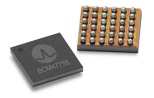
Broadcom’s BCM47755 chip. (Image: Broadcom)
However, several obstacles prevented widespread adoption of dual-band GNSS until now, including insufficient satellite coverage of a second band, which could be L2 or L5/E5, high chipset prices, and challenges in fitting these integrated circuits and related antennas into small devices such as smartphones.
“On the availability side, this year has seen several satellites launched into orbit every month, most of them fitted with L5/E5 capabilities, and the Chinese and European Union governments plan to have their satellite constellations fully operational by 2020. L5/E5 devices will not be left in the dark,” said Henrique Rocha, a research analyst for Location Technologies at ABI Research.
Furthermore, new breakthroughs from key chipset manufacturers are disrupting this market by overcoming the barriers to mass dual-frequency adoption. With Location-Based Services (LBS) applications in mind, Broadcom has released the BCM47755 dual-band location hub, claiming the system’s architecture achieves the synergistic benefits that cannot be reached by multiple integrated circuits (ICs), thereby reducing its overall size and power consumption.
Other important players in this market have also come forward with dual-frequency solutions, including Qualcomm with the Snapdragon X24 LTE modem and HiSilicon with the Kirin 980 system-on-a-chip. Both attribute their superior energy efficiency and form factor to intelligent data processing and a FinFET transistor design. Other chipset manufacturers such as MediaTek are expected to follow suit and present their own dual-band products for LBS.
The Xiaomi Mi 8. (Photo: Xiaomi)
At the consumer level, considering the handset market is the largest GNSS segment, accounting for 85 percent of all GNSS chipset shipments in 2018, the launch of the dual-frequency Xiaomi Mi 8, Xiaomi Mi Mix 3 and the Huawei Mate 20 following such breakthroughs in the chipset industry is a significant development because it opens a new lane of competition between smartphone manufacturers.
It is expected that dual-frequency devices will dominate the high-end smartphone market in a matter of a few years, and by 2023 dual-band GNSS ICs will comprise 36% of total GNSS LBS IC shipments worldwide.
Triple-frequency chips. In other significant markets for multi-frequency GNSS, such as surveying and automotive applications, triple-frequency chipsets are being released, including STMicroelectronics’ TeseoAPP and u-blox’s F9. Adding a third frequency allows for better noise correction and higher accuracy compared to dual-frequency.
Image: u-blox
ABI Research believes that triple-frequency devices will see, at least for now, a relatively shy adoption as manufacturers will need to justify the cost and overcome the power issues they tackled for dual-frequency devices.
“For LBS the comparatively small accuracy gain going from dual- to triple-frequency GNSS is not worth the extra effort — for now. However, we will probably see triple-frequency GNSS take off when cars fitted with advanced driver assistance and autonomous driving systems begin to ship in large quantities,” added Rocha.
With full satellite operability of the main GNSS bands on the horizon and chipset manufacturers overcoming past hurdles for implementing dual-frequency solutions, it is likely a matter of time before most major companies in the segment scramble for a piece of this promising market. OEMs now need to show customers that dual-frequency GNSS can indeed deliver the accuracy they have promised so new location use cases can be sustained and introduced to the market.
By Changfeng Yang, Chief Architect of BeiDou Navigation Satellite System
Changfeng Yang
As one of the four major GNSS providers, the establishment of BeiDou Navigation Satellite System (BDS) has been steadily developed, following a three-step strategy. By around 2020, BDS will form a nominal space constellation consisting of 30 satellites, including three satellites in geostationary Earth orbit (GEO), three satellites in inclined geosynchronous satellite orbit (IGSO) and 24 satellites in medium Earth orbit (MEO). It will provide global users with open and high-quality services free of charge, including navigation, positioning, timing, short message communication, search and rescue and so on.
BDS is aimed at developing into a world-class global navigation satellite system, with innovative and advanced technologies, extraordinary user experience, international development and worldwide presence, which can provide fundamental time and space reference for national defense and economic-social development, and advance the progress of high-tech and IT industries.
BDS has initiated several innovative attempts in the fields of both international satellite navigation and domestic aerospace for the first time, and paved a unique development path of a satellite navigation system, with an eye on the state conditions and distinctive features. On Jan. 9, 2017, the BD-2 Project won the top National Scientific and Technological Progress Award. In 2017, BDS achieved fruitful results in the aspects of system construction, integrated applications and international development.
System Construction
Through upgrading and reconstructing the ground system, the service performance, stability and availability of the BD-2 constellation have been improved. To achieve user-oriented services, the updated Interface Control Document (ICD) for B1C and B2a open service signals (Version 2.1) was released in accordance with the constellation change.
The international GNSS Monitoring and Assessment System (iGMAS) has been built, consisting of eight domestic monitoring stations and 16 overseas stations, to monitor and assess the service performances of BDS, GPS, GLONASS and Galileo at real-time worldwide. It has taken all factors into consideration, including constellation status, signal-in-space, navigation message, service performance and high-precision products, and so on. According to its analysis results, the nominal positioning accuracy of the BD-2 system in the coverage area has been optimized from 10 meters to 8 meters.
Development of the BD-3 System. On Nov. 5, the first pair of the 24 BD-3 MEO satellites were successfully launched, while another pair is planned to be launched by the end of the year.
Liftoff of the first pair of the BD-3 MEO satellites on Nov. 5, 2017. (Credit: Xinhua)
The BD-3 satellites are equipped with B1C and B2a signals with optimized performance, which are compatible and interoperable with other GNSS signals. The interface control document of B1C and B2a signals (beta version) was released in September. The BD-3 satellites also adopt the higher-performance rubidium atomic clock with stability of E-14 and hydrogen atomic clock with stability of E-15. By utilizing new technologies, the signal-in-space (SIS) accuracy will be superior to 0.5 m; the position accuracy will be doubled or quadrupled, and reach 2.5 m to 5 m.
The BD-3 system will retain the short message communication service of its predecessors, and further enhance basic positioning, navigation and timing (PNT) service capabilities. Satellite-based augmentation system (SBAS) and search-and-rescue (SAR) services will be added and developed according to international standards.
After in-orbit tests and networking validation, the BD-3 satellites will be able to provide operational services, and accelerate the global coverage of BDS.
Ground-Based Augmentation. The Phase I construction of the BDS/GNSS ground-based augmentation system has been completed, consisting of 150 framework reference stations, 1,200 reference stations of higher density network, national data processing center, six industrial data-processing centers, and manufacturing of user terminals. This system has achieved basic service capabilities, and its service performance standard (version 1.0) has been released. Through integration with the internet, a cloud platform has been established to provide high-precision space-time information services, including real-time navigation services at meter-level and decimeter-level, as well as precise positioning services at centimeter-level and millimeter-level.
Satellite-Based Augmentation. Based on the International Civil Aviation Organization (ICAO) standards, system demonstration and validation work on the BeiDou Satellite-Based Augmentation System (BDSBAS) has been completed, and the technical status of the system has been confirmed in accordance of the next-generation SBAS Dual Frequency Multiple Constellation (DFMC) standards.
Integrated Applications
Currently, a great number of independent, self-controlled intellectual property rights on the fundamental BDS products have been achieved. World-class, advanced technologies have been developed. With the release of the first Chinese in-house developed meter-level fast positioning BDS chip, BDS applications have begun to embrace the era of meter-level positioning.
In 2017, the sales volume of BDS navigation chips and modules exceeded 50 million pieces, and that of high-precision surveying boards and navigation antenna captured 30% and 90% of market shares respectively. There are more than 14,000 enterprises (including more than 50 publicly listed companies), and more than 450,000 employees in China engaging in BDS-related business.
The annual output value of the publicly listed company in 2017 is more than RMB 50 billion (US $7.53 billion). The number of terminals produced by domestic enterprises surpasses 40 million pieces/sets. BDS has gained recognition from mainstream chip producers such as Qualcomm, Trimble, Hemisphere GNSS, Huawei, Samsung, u-blox, MTK, Broadcom, NovAtel and more, and the total number of terminals is estimated to surpass 300 million pieces or sets.
BDS continues to:
promote integrated applications and development of related industries;
bring GNSS high-precision services in combination with cloud computing, Internet of Things, big data and other technologies;
push forward the integration between BDS-related industries and high-end manufacturing, software, and integrated data industries.
BDS has been applied in the transportation, logistics, emergency rescue, marine fishing and other fields, which has greatly improved production efficiency, reduced resource consumption, and lowered pollution. For example, benefiting from the BDS applications in traffic management industry, the number of major accidents has decreased by 46.7%, and the death toll has been reduced by 48.9%. With BDS-based maritime applications, more than 10,000 lives have been saved.
BDS/GNSS augmentation services have been applied to precision agriculture, land mapping, monitoring on deformation and displacement of large-scale public facilities, and earthquake and geological hazard measurement and survey; the latter has provided important monitoring for public safety. As a result, the production of precision agriculture has increased by 5%, and the oil consumption by agricultural machinery has decreased by 10%. The time for surveying and mapping of national land is shortened from a few days to several seconds.
BDS has been fully put into mass applications. BDS-based navigation services have been adopted by various enterprises, such as Huawei, ZTE, Baidu, Autonavi, Alibaba, JD and others in the fields of manufacturing of mobile and smart terminals, location-based services (LBS), e-commerce, and so on. BDS-based LBS have been widely applied in the mass consumption sector and people’s livelihood, and many innovative applications have emerged, such as caring for seniors and children, shared vehicles, BDS-based logistics, and so on, which have been changing people’s lives and providing more convenience for the public.
International Development
At present, BDS has covered more than 50 countries and more than 3 billion people. BDS-related products have gained access to the markets of more than 70 countries and regions, more than 30 of which are along the (land-based) Belt and (maritime) Road (in line with the Belt and Road Initiative). Through joint applications with other compatible navigation satellite systems, BDS provides global users with diversified choices for better application experience.
Meanwhile, the iGMAS has contributed to the implementation of the Asia-Pacific Space Cooperation Organization project, iGMAS-International GNSS Service Pilot experimental project, and Sino-Russian monitoring and assessment cooperation, and has provided GNSS users with authentic third-party assessment results. China continuously pushes forward BDS to be recognized by the ICAO, International Maritime Organization (IMO), mobile communication standard Partnership Project and other organizations, to serve the world in line with international conventions.
In October, three PRN codes which are essential to the development of BDSBAS were assigned; the SBAS service provider identifier and UTC standard identifier have been assigned to BDSBAS by ICAO, which marks BDSBAS an official SBAS provider in the ICAO family, and lays the foundation for the follow-up construction of BDSBAS, as well as its provision of standard navigation services for the civil aviation sector.
In March, a multi-system (including GPS, BDS and GLONASS) ship-borne receiver standard was approved by the IMO. BDS has also been included in the PNT guidelines of maritime applications.
In the field of mobile communication, 26 technical standards that support the BDS positioning function have been adopted by the third- and fourth-generation mobile communication standard Partnership Projects.
Future Plans
BDS will keep improving its continuous stability and service accuracy. Two more BD-2 replacement satellites will be launched in 2018, ensuring its regional service performance will be remain stable and be enhanced.
Eighteen BD-3 MEO satellites and one BD-3 GEO satellite will be launched by around the end of 2018. Upon the deployment of those 19 satellites, BD-3 will possess the initial operational capability and serve the countries along the Belt and Road. The official version of ICD for B1C and B2a open service signals, as well as other system documents, will be released, in line with the operational status of BD-3 satellites, for the convenience of public applications.
In regard to augmentation systems, China plans to complete the construction of Phase II BDS/GNSS ground-based augmentation system in 2018, and advance the recognition of BDS-based high-precision services as public goods. In 2018, the first BDSBAS GEO satellite with the BDSBAS payload will be launched to start the deployment of the BDSBAS system.
In terms of applications and international development, China will give full play to the role of BDS in the integration procedure between industrialization and IT applications, to promote the development of information industry, adjustment and upgrading of industrial structure.
China will also strengthen the cooperation and communication with other navigation satellite system providers, carry out coordination under the framework of international organizations and multilateral platforms, improve the international development of BDS, provide better services for users along the Belt and Road, and expand BDS services to serve users worldwide.
Rohde & Schwarz and MediaTek have successfully completed the verification of location-based services (LBS) in the U-plane and C-plane for Assisted Beidou (A-BeiDou), China’s GNSS satellite positioning system.
The R&S TS-LBS test solution allows mobile manufacturers, chipset manufacturers, test houses and network operators to verify chipsets and mobile devices in order to obtain permission to operate them in a particular network.
The successful A-BeiDou verification of the MediaTek device under test (DUT) using the Rohde & Schwarz test system marks an important milestone in the GNSS evolution of positioning and navigation. According to Rohde & Schwarz, this was the first time that the setup could be used to validate and verify a device for A-BeiDou location-based services.
The R&S TS LBS from Rohde & Schwarz is a test system for testing GNSS and network-based LBS. It consists of an R&S CMW500 as the base station simulator and an R&S SMBV100A GNSS simulator. The R&S CMW500 provides assistance data to the DUT and the R&S SMBV100A simulates the BeiDou satellites. The R&S TS-LBS test system can be used to obtain GCF and PTCRB certification as well as network operator-specific certification for chipsets and mobile devices.
“We are delighted to collaborate with MediaTek and to contribute our test and measurement expertise to the development of A-BeiDou location based services,” said Alexander Pabst, vice president of Systems and Projects within the Rohde & Schwarz Test & Measurement Division. “Rohde & Schwarz already has a strong global footprint with testing solutions for A-GNSS, such as A-GPS or A-GLONASS, and for OTDOA/eCID. Thanks to our close cooperation with our partners, Rohde & Schwarz is committed to accompanying the evolution from existing to new satellite systems such as A-BeiDou with our innovative test and measurement solutions.”
“MediaTek is committed to developing and testing the latest mobile technologies and standards to drive the industry forward,” said TL Lee, general manager of the Wireless Communications Business Unit at MediaTek. “We have worked closely with Rohde & Schwarz to develop and validate the test solution for A-BeiDou LBS, verifying the A-BeiDou proof-of-concept trial system based on the R&S TS-LBS and MediaTek DUT. This represents an exciting step forward in the evolution of LBS technology, enabling the mobile ecosystem to verify chipsets and mobile devices on the new LBS technology.”
With an in-depth look at market opportunities and trends across eight market segments, the European GNSS Agency’s (GSA’s) annual GNSS Market Report serves as a key resource for navigating the fast-evolving world of satellite navigation technology and GNSS applications.
The fifth edition, the 2017 GNSS Market Report, was released May 10 by Carlo des Dorides, executive director for the GSA, at the European Navigation Conference held in Lausanne Switzerland.
According to the new report, the growing demand for precise location information, in combination with the ongoing evolution of GNSS technology, means that today’s GNSS market is bigger than ever.
According to the 5th edition of the GSA’s popular GNSS Market Report:
The global GNSS market is expected to grow from 5.8 billion devices in use in 2017 to an estimated 8 billion by 2020.
The GNSS downstream market is expected to produce over € 70 billion in revenue annually in 2025. When the revenue created by added-value services is included, this number could more than double.
The global GNSS downstream market is forecast to grow by more than 6 % annually between 2015 and 2020. Following the declaration of Galileo Initial Services in 2016, chipset and receiver manufacturers and application developers are leveraging Galileo signals, and a number of Galileo-ready devices are already on the market.
By 2025, the installed base of GNSS devices in drones will reach 70 mln, more than twice the sum of other professional market segments combined.
Regularly referenced by policy-makers and business leaders around the world, the GNSS Market Report serves as the go-to resource for an in-depth look at GNSS market opportunities and trends across an array of essential market segments.
“Providing in-depth information on today’s GNSS market opportunities and a data-driven forecast of its evolution through to 2025, this edition is a must-read for anyone looking to successfully navigate this promising market,” des Dorides said.
The GNSS Market Report takes a comprehensive look at the global GNSS market, providing a thorough analysis per market segment (Location-Based Services, Road Transportation, Aviation, Maritime, Rail, Agriculture, Surveying and Timing & Synchronisation), region and application type, including information on shipments, revenues and installed device base.
The 2017 edition includes such new features as:
An expanded section on macro-trends like the Internet of Things (IoT), Smart Cities and Big Data.
Segment-specific user perspectives, with an emphasis on the increasingly stringent demands of today’s GNSS users.
The unique added-value that European GNSS (EGNOS and Galileo) brings to each segment and how Galileo is already enhancing the functioning of many applications.
A special feature on the important role that GNSS plays in the growing market of drones (i.e., UAVs/Remotely Piloted Aircraft Systems).
The full 100-page report is available for download free of charge.
Methodology
The GSA GNSS Market Report is compiled by the GSA and the European Commission and was produced using the GSA’s systematic Marketing Monitoring and Forecasting Process.
The underlying market model uses advanced forecasting techniques applied to a wide range of input data, assumptions, and scenarios to forecast the size of the GNSS market in terms of shipments, revenue, and installed base of receivers.
Historical values are anchored to actual data in order to ensure a high level of accuracy. Assumptions are confronted with expert opinions in each market segment and application and model results are cross-checked against the most recent market research reports from independent sources before being validated through an iterative consultation process involving pertinent sector experts and stakeholders.
U.K.-startup Focal Point Positioning has unveiled two new positioning technologies. S-GPS and D-Tail represent step changes in consumer GPS processing and smartphone indoor positioning, the company said.
S-GPS is a new signal processing, sensor fusion and machine learning scheme that dramatically improves the accuracy and availability of satellite-based positioning signals, the company said. The patent-pending S-GPS technology provides increased sensitivity and multipath mitigation capabilities that allow modern smartphones to maintain accurate GPS fixes deep indoors and in complex urban environments.
The improvements have the capability to address challenging navigation problems such as locating emergency mobile phone calls, navigating autonomous vehicles through dense urban environments, and improving consumer interaction with location-based services (LBS).
D-Tail is a human motion modeling system that can accurately track users in three dimensions using the inertial sensors in their smartphone or wearable devices. The result is a precise trace of the user’s motion, better than the detail and accuracy provided by dead-reckoning and Wi-Fi fingerprinting techniques. D-Tail is designed to improve the performance and accuracy of activity tracking apps and LBS analytics.
The company is starting to engage with chipset manufacturers to deploy the technologies in smartphones, according to founder and CEO Ramsey Faragher.
The TraceME module TM-178, targeted for tracing and controlling vehicles and other powered equipment, is now upgraded with optional LoRa, Wi-Fi, Bluetooth Smart (BLE), ANT/ANT+ and proprietary RF. The upgrades enable integration with existing wireless networks and specific custom mobile apps on smartphones and tablets.
The KCS BV LoRa technology offers a communication range up to 60 kilometers, line of sight. The module offers an advanced indoor and outdoor location-based positioning solution, which covers a variety of Internet of Things (IoT) applications and enables stolen object or vehicle recovery.
The TM-178 is equipped with external power and battery backup connection, basic I/O-connectivity and multiple on-board sensors. The unit contains multiple integrated antennas for GPS/GLONASS, GSM (2G/3G) and RF functionality. The functionality of the module can be remotely programmed to fit any job. From basic/general functionality to advanced/low-level application specific detailed functionality.
With a compact size of 91 x 40 millimeters and weighing 30 grams, along with a battery lifespan of more than 10 years, the module offers endless OEM integration possibilities. Optionally, the module can be ordered in a robust IP67 housing.
TM-178 Features
GPS
GSM/GPRS/EDGE coverage
Basic I/O-connectivity
Long-range RF coverage
Optional Features
GPS + GLONASS
UMTS/HSPA+
LoRa
Bluetooth Smart (BLE), ANT/ANT+, iBeacon
Wi-Fi
Robust IP67 housing
External RF antennas
Internal battery, no need for external power supply