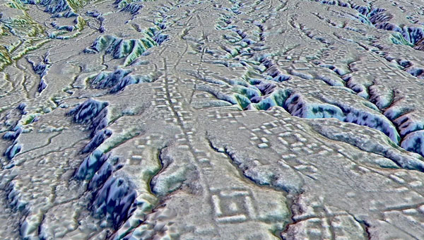
A lidar map of the city of Kunguints in the Ecuadorian Amazon reveals ancient streets lined with houses. (Image: Antoine Dorison and Stephen Rostain)
Archeologists have discovered a vast and highly complex system of ancient cities dating back nearly 3,000 years in the Amazon rainforest. Complete with a complex network of farmland and roads, the discovery is the oldest and largest of its kind in the region.
Located in Ecuador’s Upano Valley, the structures lie in the eastern foothills of the Andes mountains, according to a study published in the journal Science. After more than 20 years of research, the ancient urban centers were only discovered when the Ecuadorean government employed lidar technology.
“I have explored the site many times, but lidar gave me another view of the land,” archaeologist Stéphen Rostain, lead author of the study and director of research at the French National Center for Scientific Research (CNRS), told Live Science. “On foot, you have trees in the way, and it’s difficult to see what’s actually hidden there.”
A team of researchers from France, Germany, Ecuador and Puerto Rico conducted a lidar survey that covered roughly 300 km2. The survey revealed a landscape full of organized human activities, including more than 6,000 rectangular earthen platforms, as well as agricultural terraces and drainage systems.
According to the study, these structures formed at least 15 distinct settlements, which were connected by a system of wide, straight roads. Co-author Antoine Dorison, an archaeologist at the CNRS, said that this society’s complexity is especially evident in this web of streets, which were carefully constructed to cross at right angles rather than follow the landscape.
In recent years, lidar has been a vital tool for discovering traces of ancient civilizations. Lidar allows researchers to survey densely forested areas that are difficult to explore on foot and allows for the creation of accurate maps in a fraction of the time.
In August 2023, a team of researchers in a biological preserve in Mexico’s Campeche State used airborne lasers to cut through dense vegetation. This revealed ancient structures and human-modified landscapes beneath, including pyramids, palaces, and a ball court. The team was able to explore the dense area safely and identified the ancient Mayan city they discovered as Ocomtún.
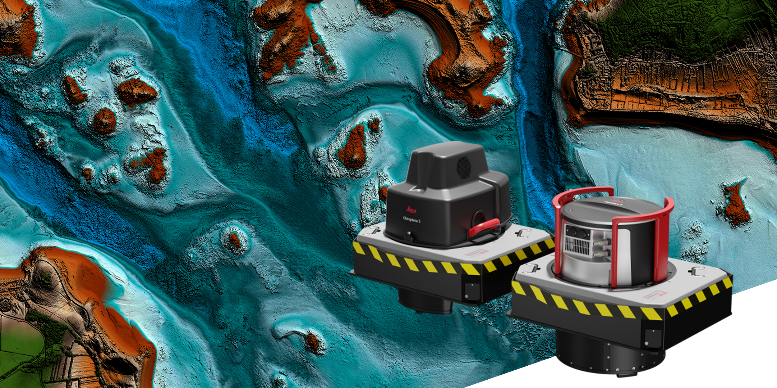
Leica Geosystems, part of Hexagon, has launched the Leica HawkEye-5, a new high-performance airborne bathymetric lidar solution for deep water surveying.
Leica’s HawkEye-5 increases survey efficiency by up to 25% compared to previous generations. The technology expands the capabilities of the Leica Chiroptera-5 bathymetric lidar system, enhancing the productivity of applications such as nautical charting, environmental monitoring, and maritime surveillance in deep waters.
The technology is designed to fit the Leica PAV100 gyro-stabilized mount, which isolates the sensor from unwanted aircraft movements — resulting in consistent data density and more efficient area coverage.
The HawkEye-5 combined with the Chiroptera-5 features three lidar sensors, one four-band camera, and a QC camera to collect data from the seabed to land.
The Lidar Survey Studio software suite provides full waveform analysis, automatic data classification and advanced turbid water enhancement to support multiple applications.
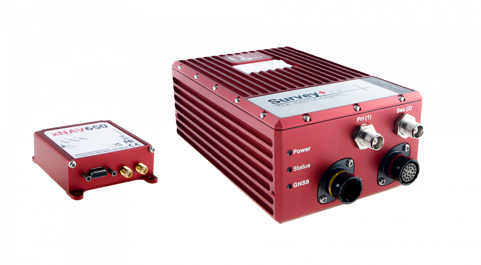
OxTS manufactures inertial navigation systems (INS) and proprietary software on which survey professionals have come to rely. Our devices, the Survey+ and the xNAV650, output highly accurate position, heading and pitch/roll measurements. An advanced navigation engine combines streams of data from onboard inertial measurement units (IMUs) and GNSS receivers. This data can then be used in a multitude of applications including lidar survey, mobile mapping and open road positioning.
Surveying, especially with a lidar sensor, can be a complicated art. There are many factors to consider even before you begin. However, system manufacturers involved in the survey industry, such as OxTS, are taking steps to simplify lidar survey.
The end goal for many lidar surveyors is to create an accurate point cloud. However, to produce the best possible results, the hardware and software involved must be working together in unison.
Hardware = lidar sensor and INS
Software = georeferencing, post-process and configuration
In this article, we have picked out a few of our favorite developments on the topic of simplifying lidar survey.
Research and Development
OxTS invests substantially in research and development to ensure that our hardware and software developments meet the ever-evolving demands of the survey industry. Many of the improvements generally center around improving accuracy, clarity of results and user experience. However, general industry demands also drive some development.
For example, the increasing use of drones in surveying has increased demand for smaller and lighter INS hardware. Whilst developing smaller and lighter hardware is therefore important it cannot be to the detriment of reliability and accuracy. The xNAV650 was born from this industry demand.
Although development of the xNAV650 was primarily driven by the needs of the survey industry (smaller/lighter hardware), other improvements OxTS has made to the software portfolio has focused on improving user experience.
xNAV650 and Survey+ inertial navigation systems. (Photo: OxTS)
Precision Time Protocol (PTP)
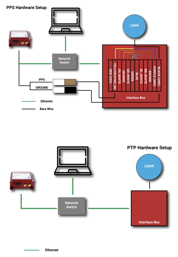
One of the major advances in OxTS INS technology over the past 12 months is PTP. The drive to include PTP capability on all OxTS Survey INS devices was the intention to help surveyors simplify the lidar survey set-up process.
When using compatible lidar sensors, such as those from Hesai and Ouster with an OxTS INS, surveyors no longer need to build complex wiring solutions. A simple ethernet ‘plug-and-play’ process is all that is required.
The images below show a traditional PPS wiring set-up vs PTP:
A traditional PPS wiring set-up vs PTP. (Image: OxTS)
Software
To get the desired outcome, an accurate georeferenced point cloud, from any lidar survey in a timely manner the software must be simple and straightforward to use. As the saying goes “complexity is the enemy of execution,” and this is what drives software development at OxTS.
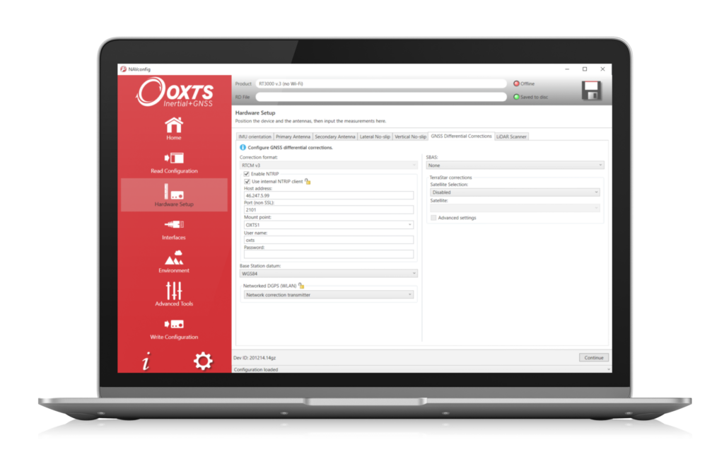
Once the lidar and INS are plugged in and ready to survey, configuration should be straightforward. A simple configuration wizard, such as the one available in NAVsuite (OxTS’ complimentary software toolbox) should structure the set-up process so that nothing is missed.
NAVconfig – OxTS’ INS configuration software. (Image: OxTS)
The latest NAVsuite update (version 3.3) included a new PTP graphical user interface (GUI) to simplify survey set-up even further.
Other tools are included within NAVsuite that allow users to analyze, troubleshoot and post-process their INS data. Read the NAVsuite for Survey and Mapping infosheet to find out more about these.
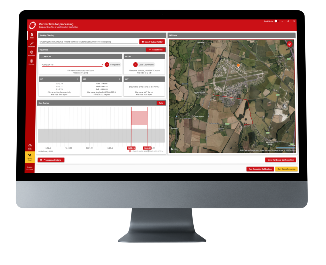
OxTS Georeferencer
OxTS Georeferencer. (Image: OxTS)
Since its launch approximately two years ago, OxTS Georeferencer has gone through some major changes. The first version included compatibility with the Velodyne VLP-16 lidar sensor. This meant that users of the VLP-16 had a quick and simple way to georeference the lidar data.
Over the course of the next 24 months, multiple new sensors have been introduced. Sensors from Hesai, Ouster, Livox and new Velodyne devices are now available, giving users more choice than ever before when it comes to choosing the hardware to do their job. Visit the OxTS Georeferencer product page for a complete list of available sensors.
Furthermore, as well as the integration of new sensors, we have introduced a raft of new features to improve the user experience for professional lidar surveyors. These include:
a 3D hardware setup viewer to enable quick and intuitive survey configuration
multiple processing options that allow users to view and process only the areas of the point cloud that are of interest therefore minimizing the data size
the ability for users to process data in a range of coordinate systems including, local coordinates, ECEF, LLA (latitude, longitude and altitude)
processing advances that enable users to process data faster than ever before.
Data-Driven Boresight Calibration
One of the most challenging parts of the lidar survey set-up process is aligning the coordinate frames of the lidar and INS devices. Failure to align these with sufficient accuracy can lead to blurring and double-vision in point clouds.
Many surveyors try to do this by eye, or by developing expensive CAD models, however there is a simpler, quicker and more cost-effective way – using data.
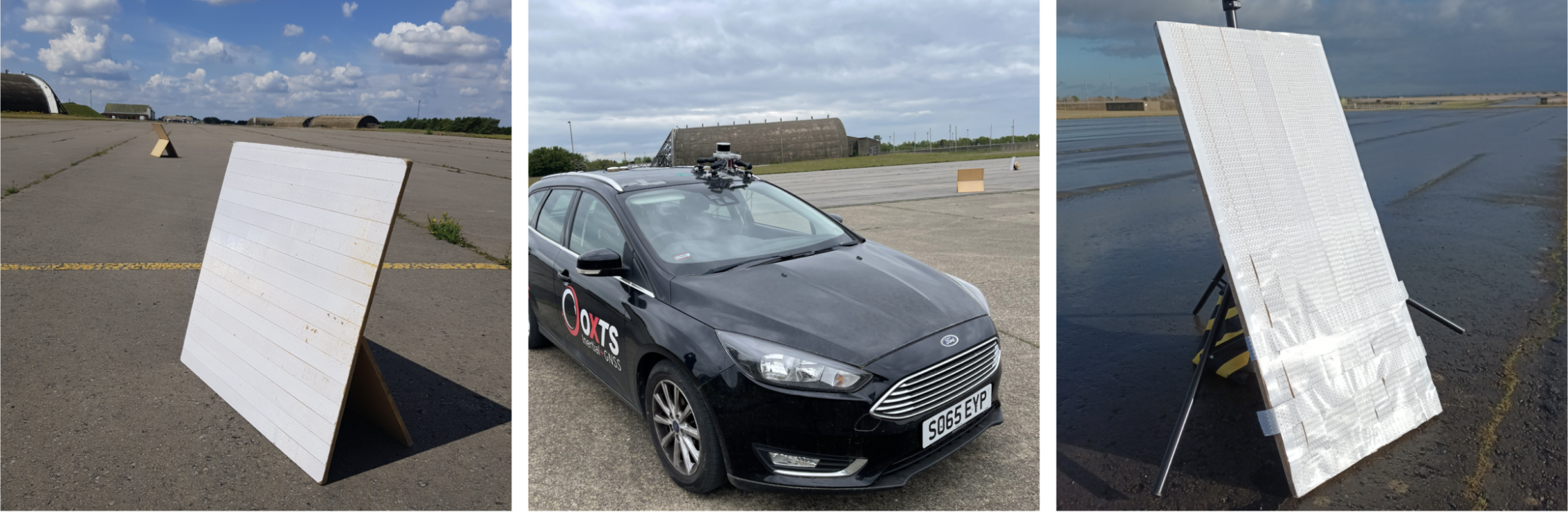
Built into OxTS’ lidar georeferencing software OxTS Georeferencer, there is an optional boresight calibration tool. It requires the surveyor to survey two static “targets” (see the images below) from multiple distances and angles. The data is then calibrated, and the angle displacement calculated to a tenth of a degree.
OxTS Georeferencer includes an optional boresight calibration tool. (Photos: OxTS)
Once the initial boresight calibration has taken place, if the setup is not altered in any way, the coordinate frame alignment will be valid for any future survey.
The Future
In the coming weeks and months, the development of new hardware and software features will further streamline the survey process.