One industry important to the world’s fight and recovery from the COVID-19 pandemic is geospatial analytics. In response, the World Geospatial Industry Council (WGIC) has created an information hub for COVID-19 information.
“These are very uniquely challenging times for our industry. At the same time, our industry has stood up to assist the world, especially the key decision-makers and frontline workers to understand the scenarios on the ground,” said Harsha Vardhan, WGIC associate director. “Spatial analytics-based decision making has come to the forefront during these times.”
Governments are using location tracking in combination with personal data to track and combat COVID-19, and the use of location technology in conjunction with personal data is of high relevance and usage, Vardhan said. “This scenario brings before us the aspects of data privacy, data protection, and the role of geospatial information.”
In March, WGIC published a report titled “Geospatial Information and Privacy: Policy Perspectives and Imperatives for the Geospatial Industry.” Vardhan said the report is even more significant now. WGIC is hosting a webinar on the report on May 14 at 11 a.m. ET.
The scale and speed of the COVID-19 crisis has left policymakers searching for new tools to address an unprecedented challenge. Everything from faster testing to new treatments to more supplies for frontline providers is needed, and smart deployment of these resources requires an ability to track infections that is not yet available for a problem of the scale of COVID-19.
The recent economic stimulus package passed by Congress — the Coronavirus Aid, Relief, and Economic Security Act (“CARES Act”) – looks to fund this kind of tracking. Among its many priorities, the CARES Act appropriates half a billion dollars to the Centers for Disease Control and Prevention (CDC) for modernization of its public health data surveillance capabilities, and specifically directs the CDC to report to Congress on the development of a “public health surveillance and data collection system for coronavirus within 30 days.”
The legislation does not give much in the way of additional direction to the CDC, meaning that the CDC is likely to think expansively and look for proven models in other highly developed public health systems.
Disease surveillance efforts around the world have taken a variety of approaches, in many cases informed by experience in battling prior pandemics. Public health systems in places such as South Korea, Singapore and China were built on the lessons of the outbreak of Severe Acute Respiratory Syndrome (SARS) and similar conditions over the past several years.
Location-based tracking using GPS provides greater insight and precision than, for example, asking an infected patient to remember and re-trace his or her steps.
Among many other elements, these systems frequently employ GPS-enabled smartphone apps both to gather information and to target alerts to local populations. Location-based tracking using GPS provides greater insight and precision than, for example, asking an infected patient to remember and re-trace his or her steps.
As discussions of similar solutions have begun in the United States, privacy advocates have rightly pointed out the risks inherent in systems that necessarily gather and communicate health information and pair that information with location-based information provided by GPS. But both legally and practically, there need not be an exclusive choice between health information privacy and using GPS and other technology to gather and provide information about COVID-19.
On the legal front, HIPAA broadly exempts disclosures of protected health information for public health activities, allowing disclosures to public health authorities without first obtaining patient consent. Similarly, HIPAA permits data to be de-identified — subject to recognized standards laid out in regulations and guidance — and thereafter shared and used for research purposes, including public health research and similar purposes.
Legal avenues certainly exist to permit significant information sharing about COVID-19 in order to help protect public health.
Furthermore, federal authorities tasked with enforcing HIPAA have already signaled in guidance that they will take a flexible approach to enforcement in order to meet the exigencies of the crisis. Thus, while it is true that HIPAA has not been applied directly to a public health emergency on the scale of COVID-19, legal avenues certainly exist to permit significant information sharing about COVID-19 in order to help protect public health.
On the practical front, HIPAA also points the way to sensible decision-making that balances privacy interests with the needs of the crisis. First, de-identification provides a significant opportunity to share data in a way that is protective of privacy. Second, we should not assume that widespread participation — both in information gathering and information dissemination — must be involuntary in order to be widely adopted.
Smartphones users can — and should — be given a choice before enabling tracking features on their devices, just as they can and should be informed in a transparent way about what data would and would not be shared. HIPAA establishes a “minimum necessary” standard that should provide the guiding principle here: no more information should be shared than is necessary to accomplish the intended objective.
As we search quickly for tools to enable the kind of tracking that we have not undertaken before, we should be careful not to construct a false dilemma between privacy and efficacy — the two go hand in hand. Strong and transparent privacy protections are both possible and necessary to secure the public buy-in that is necessary to make public health surveillance work.
Jeremy Meisinger is a Boston-based attorney at Foley Hoag LLP.
The tools connect directly to TomTom Maps APIs (Application Programming Interfaces) for location, tracking and mapping data services, accelerating product development, and reducing time-to-market and development costs for developers, the companies said.
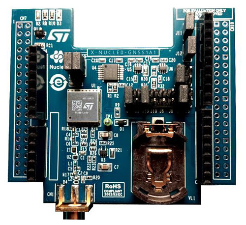
The X-NUCLEO-GNSS1A1 expansion board is based on the Teseo-LIV3F tiny GNSS module. (Photo: STMicroelectronics)
The development package consists of an STM32 Discovery host board for 2G/3G cellular-to-cloud connectivity, a GNSS expansion board based on ST’s Teseo satellite navigation technology, and a software Function Pack that connects an internet-of-things (IoT) node via a cellular network to a range of TomTom Maps APIs.
With this hardware and software package and a TomTom developer account, developers can quickly add location-based services to their IoT and smart city applications.
Among these services are the translation of GPS coordinates into a street address inside a map (Reverse Geocoding), retrieval of nearby point of interests, and the production of accurate navigation directions.
“We have combined TomTom’s industry-leading location-based and mapmaking technologies with ST’s unrivaled combination of silicon and system expertise to create a unique offering that provides easy access to TomTom’s Maps APIs to empower developers to create groundbreaking, location-aware applications faster and more efficiently,” said Anders Truelsen, managing director of TomTom’s Enterprise Business Unit.
“Supporting our efforts to facilitate location-based product development, our collaboration with TomTom has built on each company’s strengths to assemble a tailored package of hardware and software tools that is already fully integrated with TomTom cloud services, around the popular STM32 development ecosystem,” said Alessandro Cremonesi, group vice president at STMicroelectronics. “These tools enable native STM32-based location services to accelerate application development of Geo-IoT solutions for fleet management, item tracking, and many other services that depend on fast, accurate location detection.”
In addition to the STM32 family of Arm Cortex-M core microcontrollers, the development tools leverage ST’s market-proven multi-constellation Teseo positioning-receiver technology to perform all positioning operations including tracking, acquisition, navigation and data output.
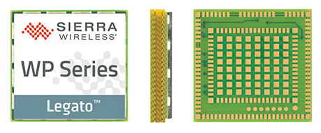
Sierra Wireless, a provider of fully integrated device-to-cloud solutions for the Internet of Things (IoT), is offering global, dual-mode low-power wide-area (LPWA) cellular modules. The AirPrime WP77 smart wireless modules simplify LPWA deployments for customers developing products that need to connect to multiple networks where different LPWA technologies are supported.
The Sierra Wireless AirPrime WP Series.
The WP series simplifies development for secure telematics and gateway applications, providing a dedicated application CPU core running the Linux-based open source Legato application framework.
With integrated GNSS for tracking and location-based services, low-power modes and a comprehensive set of interfaces for connecting sensors and companion chips, including Wi-Fi and Bluetooth, customers can develop multi-service platforms for the transportation market, and use the WP77 for applications requiring low throughput and optimized power performance.
The WP77 supports both LTE-M (Cat-M1) and NB-IoT (Cat-NB1) with optional 2G fallback, allowing customers to deploy the same device with multiple network operators worldwide. For those deploying in regions where 4G LTE coverage is not as widely available, 2G fallback ensures their devices stay connected to the network.
ABI Research forecasts that cellular LPWA network technologies will begin to see rapid growth from 2018 onward as carriers upgrade their networks in 2017, however, carriers have varying plans and timelines for LTE-M and NB-IoT.
“A module with dual-mode, global coverage will be very attractive for global equipment manufacturers, especially for applications such as telematics, metering, and location tracking, which we expect will lead the way for LPWA volume deployments,” said Dan Shey, managing director and vice president at ABI Research.
With the commercialization of LTE-M and NB-IoT LPWA technologies, cellular is now a superior option for many IoT applications that were previously restricted to short-range technologies due to cost and battery life. LPWA technologies combine lower cost, broader coverage and better battery life with globally available and secure cellular networks and will connect millions more things to the Internet.
“With the AirPrime WP77 modules, IoT developers have everything they need in a single module to quickly build low-power connected products that can be deployed anywhere in the world,” said Dan Schieler, senior vice president and general manager, Embedded Solutions, Sierra Wireless. “The integrated open source Legato platform and AirVantage cloud provide our customers with a proven device-to-cloud architecture to design innovative LPWA solutions that extend the IoT into new applications.”