Tag: location

  • BDStar unveils chip-cloud integrated business strategy

    BDStar unveils chip-cloud integrated business strategy

    BDStar Navigation Co. Ltd., a provider of positioning technology solutions, has announced its chip-coud integration strategy and introduced intelligent location digital base (iLDB) in Frankfurt, Germany.

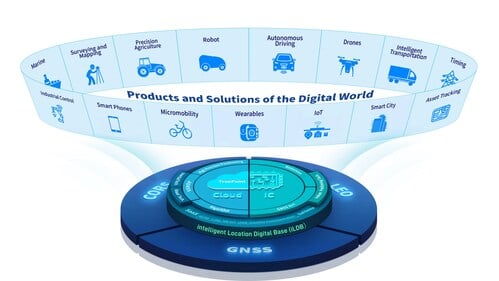
    iLDB leverages a distributed chip-cloud architecture to create a unified technology and service system. Guided by the chip-cloud Integration paradigm, it combines focused R&D with cross-technology synthesis. This approach delivers robust positioning solutions and powers the integration of physical and virtual environments.

    By establishing the iLDB, BDStar has created a closed-loop ecosystem for its positioning products and services, encompassing algorithms, chips/modules, antennas and data services within a unified framework. The company’s solutions deliver on-demand positioning that is all-weather, all-scenario, secure, reliable and intelligently adaptive, serving a wide range of sectors, including intelligent driving, outdoor robotics (such as robotic lawn mowers), unmanned aerial vehicles, and smart wearables across industrial, automotive and consumer markets.

    Positioning for Europe. Aligned with the iLDB strategy, BDStar also introduced its new high-precision positioning data service for the European market. Built on network real-time kinematic (NRTK) technology, the service offers broad coverage across Europe and provides customers throughout the region with centimeter-level, real-time positioning accuracy within seconds.

    Founded in 2000, BDStar ranks among the world’s top ten suppliers of GNSS core components. In 2025, the company’s global GNSS chip/module shipments are expected to exceed 100 million units. Many leading international brands are already integrating BDStar’s GNSS chips, antennas, and data services into next-generation products designed to address changing market demands.

    David Zhou, vice president of BDStar, said the company’s chip-cloud integration strategy delivers multiple benefits through one-stop design, supply and support, enabling reduced cost, enhanced efficiency, assured security, single accountability, and rapid, effective troubleshooting.

    Ruxin Zhou, founder and chairman of BDStar, emphasized the company’s global vision. “With our chip-cloud integrated model, BDStar will strengthen worldwide partnerships and continue building a world-class, globally covered iLDB,” he said. “We are committed to creating long-term value for our customers and driving progress in the intelligent era.”

  • Esri launches indoor mapping solution

    According to Esri, ArcGIS Indoors applies the latest location technology to allow users to see and share where assets, rooms, departure gates and offices are located. Click to enlarge. Photo: Esri

    Esri has debuted ArcGIS Indoors, which is designed to enable interactive indoor mapping of corporate facilities, retail and commercial locations, airports, hospitals, event venues, universities and more.

    According to Esri, the solution applies the latest location technology to allow users to see and share where assets, rooms, departure gates and offices are located.

    ArcGIS Indoors uses data streams, real-time processing and location intelligence tools to help businesses and other organizations understand how to better coordinate space and other resources with their facilities and campuses. Insights from sensor networks deliver real-time information to managers and executives through interactive dashboards, while visitors and employees can find useful information about the buildings they occupy, the company said.

    The solutions also allows users to quickly access and explore critical business information, such as the location and status of fire extinguishers and their last inspection dates.

    “ArcGIS Indoors brings the interior building space into the future by placing data about employees, schedules, meetings, customers and events into a geographic context,” said Nitin Bajaj, product manager at Esri. “Having spatial awareness gives executives, managers and employees better insight so they can operate more efficiently and competitively.”

    According to Esri, ArcGIS Indoors will be available for widespread use by the end of 2018. In addition, a beta version of the product will be released at this year’s Esri User Conference, taking place July 9-13 at the San Diego Convention Center in San Diego, California.

  • 5G, internet of things highlighted in webinar

    Testing autonomous driving support. (Photo: Volvo).
    Testing autonomous driving support. (Photo: Volvo).

    Location, principally provided by GPS/GNSS, plays a key role alongside deployment of 5G cellular networks, in the realization of the internet of things (IoT).

    A free webinar hosted by GPS World on May 17 will cover how location plays a role in the internet of things. The webinar will include presentations by Fergus Noble, co-founder and CTO of Swift Navigation; Oliver Cameron, co-founder and CEO of Voyage; and Steve Thompson, senior director and office of the CTO of Acorn Technologies.

    During his presentation, Noble will highlight the benefits of integrating a cloud corrections service with high-precision GNSS receivers. He also will provide an understanding for users of GPS about how high-precision GNSS receivers benefit from a cloud corrections service, including high-precision results in seconds and increased geographic range.

    Cameron will cover why private cities make for the perfect first deployments of self-driving cars and Thompson will offer an overview on cellular positioning technology for ultra-low-cost, ultra-long-battery-life IoT applications.

    Register and learn more about the webinar, which takes place at 1 p.m., here.

  • Raytheon contracted to demonstrate Army mobile intelligence platform

    FoXTEN software product gives soldiers access to real-time intelligence data in the field.

    Raytheon Company has been awarded a U.S. Army contract to demonstrate the company’s commercially available mobile intelligence platform that will allow soldiers to quickly collect and access information on the battlefield.

    Raytheon’s commercial laptop-based platform, called the FoXTEN, may be considered as a future mobile component of the Army’s Distributed Common Ground System (DCGS).

    FoXTEN provides mapping functions in both MIL-STD-2525B and MIL-STD-2525C symbology.

    DCGS is an intelligence, surveillance and reconnaissance system that enables deployed soldiers to collect, process and display intelligence information from a variety of sources and sensors. The Army is upgrading its existing DCGS system with a series of new components and capabilities, including the mobile platform.

    “Our soldiers need real-time access to intelligence and surveillance data, and FoXTEN is designed to get that information to and from the most remote edges of the battlefield,” said Todd Probert, vice president of mission support and modernization at Raytheon Intelligence, Information and Services. “We’ll be bringing our deep experience integrating the best commercial software into a system our soldiers can trust to keep them constantly aware of threats and give them the advantage they need to win on any battlefield.”

    Under the contract awarded by the U.S. Army Contracting Command, Raytheon will demonstrate the company’s FoXTEN software product, which can be loaded onto a commercially procured laptop and easily deployed and used by soldiers operating in the field.

    FoXTEN quickly connects warfighters to intelligence from various sources, giving them the real-time information they need to make mission decisions across all battle domains. FoXTEN, when loaded onto a laptop, is lightweight, requires little power and can operate at low-transmission speeds.

    “Our system is intuitive, easy to use and only takes eight hours of training compared to the current system,” said Probert. “It’s also completely open, allowing the Army to integrate new capabilities from any developer. The system is designed from the ground up to be easily upgraded so our soldiers always have the best technology and intelligence in their hands.”

    The Army will conduct a series of operational tests of the FoXTEN software over the next year before making a final procurement decision.

  • Comtech launches Location Studio at CTIA Super Mobility

    Comtech launches Location Studio at CTIA Super Mobility

    Comtech Telecommunications Corp. has launched Location Studio, a versatile service platform for mobile operators, application developers and enterprises to build or enhance cloud-based, embedded and hybrid applications using a modular set of location-based services (LBS) tools.

    location-studioLocation Studio incorporates multiple technology suites that provide a broad range of functionality, allowing developers to create location enabled applications with contextual awareness, including:

    • GeoSuite for integration of maps, search, geocoding, routing and navigation. Also includes geofencing for triggering alerts when devices enter or exit a specified space, and Comtech’s Trusted Location solution for verifying and validating a device’s location to prevent fraudulent activity.
    • PositioningSuite, a powerful engine that can locate and track assets, such as IoT devices, seamlessly switching between inside and outside environments while minimizing device power consumption using a proprietary geofence algorithm that eliminates the need for “always on” GPS.
    • MessagingSuite, a comprehensive, carrier-grade messaging platform that supports virtually all messaging protocols and is capable of supporting personalized high-volume messaging applications for alerts and notifications, such as product and/or services information, emergency alerts, and critical internal communication.
    • AnalyticsSuite, a web-based portal for reviewing and exploring user, device or application data.

    “Location Studio encompasses two decades of location-based services experience that can be easily configured into consumer, industrial or workforce-ready applications and services while minimizing deployment timelines, costs, and resource requirements,” said Jay Whitehurst, president of Enterprise Technologies, Comtech Telecommunications Corp. and member of CTIA’s Board of Directors. “We are excited to see how this new platform influences and enables the use and impact of location intelligence across a number of different markets.”

    Location Studio supports both hosted and in-network LBS solutions and provides API’s that can be tailored to meet the specific needs of various vertical market customers, including mobile network operators, automotive OEMs, fleet and logistic organizations, insurance and financial organizations, as well as manufacturers. As part of these solution offerings, Comtech provides project management, coordination and testing support.


    Editor’s Note: Comtech placed third in the IoT category for 10th annual CTIA Emerging Technology Award at CTIA Super Mobility 2016. According to the wireless association, the winners represent the latest innovation in mobile products and services that have the power to transform networks, businesses, smart cities and connected consumers. Newell Thompson, vice president, Category Marketing, Technology & Telecommunications, Time Inc. presented the winners at the live awards ceremony at the Sands Expo.

    “CTIA Emerging Technology Award winners represent the best mobile products, apps and services of the year that have the potential to influence and benefit businesses and consumers,” said CTIA Show Director and Conventions AVP Heather Lee. “Marking the tenth year of this distinguished awards program, CTIA is honored to once again recognize companies that are raising the bar of excellence for mobile innovation.”

    A panel of 35 industry experts and analysts judged submissions across 15 award categories to determine the finalists and winners. The “Crowd Favorite” was determined by a popular vote of CTIA Super Mobility 2016 attendees and online visitors.

  • Mobile Means Business

    Sponsored by: Hemisphere GNSS
    Broadcast Date: Thursday, July 18, 2013
    Moderator: Alan Cameron, Editor & Publisher, GPS World
    Speakers: Cary Kiest, director of engineering, Trimble Mobile Computing Solutions; David Krebs, vice president, VDC Research & author of a market research study on mobile computing adoption and use by large enterprise and small-to-medium businesses.
    Summary: Organizations across business and public sectors, and including the military, now expect a high degree and broad range of functionality in the palms of workers’ hands, wherever those workers may go, under any kind of hazardous, chaotic, demanding environments. Requirements for location accuracy rise consistently across the board. In the future — in other words, now — developers will be asked to write mobile software applications first, and desktop applications second. Find out what this means for you, whether you are involved in GPS/GNSS product design, integration, marketing, sales, disribution, workforce management, or field use.
    Webinar Transcript: Mobile Means Business

  • Esri takes top award for Internet of Things innovation

    Electric-Vehicle_shutterstock_192060521-660x400
    The Smart Energy Catalyst. The project showcased how a smart home, smart electric vehicle and smart energy system can work together in an IoT ecosystem with location as a key interaction point.

    Geospatial technology company Esri was honored at the TM Forum Catalyst InFocus event for the company’s contributions to developing solutions for a more connected world. TM Forum, a global industry association for digital business, presented Esri and partners with the Most Innovative Catalyst Award.

    “We’re driving toward the ultimate Internet of Things (IoT) ecosystem where you can bring different applications together that are going to make our lives safer, more energy efficient, and much better in the future,” said Randy Frantz, telecommunications solutions director at Esri.

    Esri’s telecommunications team collaborated with Orange and BearingPoint on the award-winning proof-of-concept project called the Smart Energy Catalyst. The project showcased how a smart home, smart electric vehicle and smart energy system can work together in an IoT ecosystem with location as a key interaction point.

    The multiphase project examined the infrastructure necessary to support a smart energy ecosystem. With the latest iteration of the Catalyst, the project team demonstrated how geofencing in homes and cars can work with Esri’s geographic information system (GIS) technology. When the consumer leaves home or work, mobile devices trigger the GIS to initiate a series of notifications and actions. For example, lights in homes automatically turn off, security systems are enabled, and users are notified that their electric vehicle needs charging.

    “Location provides context to the IoT network. It transforms raw sensor data into useful, actionable information,” Frantz said.

    TM Forum’s Strategy Committee gave the award to the Smart Energy Catalyst team based on several criteria, including having a compelling and inspiring demonstration; growth potential and business value; and potential for humanitarian or other positive effects on society.

    Nearly 200 industry leaders attended the Catalyst InFocus conference, where they explored the organization’s 11 project demonstrations.

    TM Forum’s Catalyst program connects diverse companies from across industries, facilitating collaboration and fostering the cocreation of innovative solutions to pressing telecommunications business challenges. Catalysts are member-led projects and demonstrations that both inform and leverage TM Forum best practices and standards including TM Forum Frameworx.

    The organization announces Catalyst Awards biannually. Winning teams leverage proven technologies, competencies, and investments. Teams have six months to develop proofs of concept that outline digital solutions.

    In addition to his work on the Smart Energy Catalyst, Frantz accepted a position earlier this year as colead of TM Forum’s IoT work stream. The endeavor explores how location, advanced sensor and device data, and powerful industrial and consumer solutions can change social norms and bring business into the modern technology framework.

    TM Forum includes more than 900 member organizations and 85,000 individual members.

    Photos: Esri

    The Esri team at the TM Forum.
    The Esri team at the TM Forum.

  • what3words Uses 3 Words as Coordinates to Identify Location

    what3words explains its coordinates system based on words while at the 2015 Esri Federal GIS Conference, held Feb. 9-10 in Washington, D.C. what3words splits Earth’s surface into 57 trillion 3-meter by 3-meter squares, and gives each square a unique combination of three words — replicated in eight languages — that identifies the area.

  • Placed Adds Location Analytics

    Placed Analytics is a new service that will provide perspective on the places that people were physically nearby when interacting with specific content. Placed Analytics expands the platforms it supports beyond Android and iOS to include the mobile web.

    “We chose mobile web as our next platform because mobile site owners have been requesting the same level of insights as app developers. Additionally, the early adopters of Placed Analytics are also the same developers embracing HTML5 as an alternative to native app development,” said David Shim of Placed. “Placed has measured over 1 billion locations since launching our beta to the public back in June. This rate of adoption has surpassed all of our internal goals, and the addition of mobile web measurement should only accelerate growth.”

  • Expedition 12: The Value of Location

    DMTI Spatial (DMTI) is sponsoring Expedition ’12: The Value of Location, its fourth annual user conference.

    As Location Intelligence continues to become one of the biggest waves in technology, it’s never been more critical to understand the impact it will have on your business, organizers said. This conference will be held at The Fairmont Royal York Hotel in Toronto, Canada.
    Register before April 23 to receive a 10 percent discount off the delegate fee of $99.