A new paper by two Qualcomm engineers imagines restructuring Loran technology to more easily incorporate timing signals into telecommunication systems.
The paper, titled simply “LORAN-5G,” was authored by Guttorm Opshaug and Dave Tuck. It envisions moving away from legacy pulsed signals to a more continuous wave form which would allow significantly lower power transmissions.
According to Opshaug, “Another big advantage that may not be as apparent, is the built-in orthogonality in the signal structure of OFDM. This means that a receiver would be able to detect very weak signals from distant towers at the same time as receiving signals from a very strong close tower. Such robustness towards near-far effects is critical for terrestrial navigation use.”
Another change would be a marked increase in the capacity of the Loran data channel to more than 2.6kbps. “This could open opportunities for additional service options and/or reduce latency of existing ones,” according to Tuck.
UrsaNav CEO, Charles Schue, expressed great interest in Qualcomm’s paper. UrsaNav is a long-time provider of Loran equipment and consulting. “The intersection of PNT and communications discussed in the Qualcomm paper is exactly what is needed to ensure that PNT systems evolve and stay relevant,” he said. “In fact, we build our software defined transmitter and receiver solutions to specifically include the ability to produce and use these types of signals.” A Cooperative Research and Development Agreement between UrsaNav and the Department of Homeland Security demonstrated these type of potential upgrades in 2012.
This paper is the first publicly released effort examining the use of Loran technology to support 5G telecommunications. The general concept was discussed in a 2016 paper by the Alliance for Telecommunications Industry Solutions’ (ATIS) Synchronization Committee. Based on the paper, ATIS in 2017 encouraged members of Congress to pass legislation that would become the National Timing Resilience and Security Act of 2018 (NTRSA).
There are tradeoffs. Opshaug and Tuck’s proposal would replace the legacy Loran standard signal with a new one.
“I was in the midst of developing proposals for the 3GPP standards organization when I first heard about the NTRSA,” said Opshaug. “5G seemed like exactly the kind of critical infrastructure that could benefit from a backup timing solution.”
“We wanted to bring some of the ideas used to develop 5G position and timing to Loran,” said Tuck. “Using Loran as the timing synch could enable 5G to improve overall infrastructure resilience.”
Yet, as with most things, there are tradeoffs. Opshaug and Tuck’s proposal would replace the legacy Loran standard signal with a new one. This would require redesign of receivers and some transmitters. The proposal could support denser deployments to further improve resiliency.
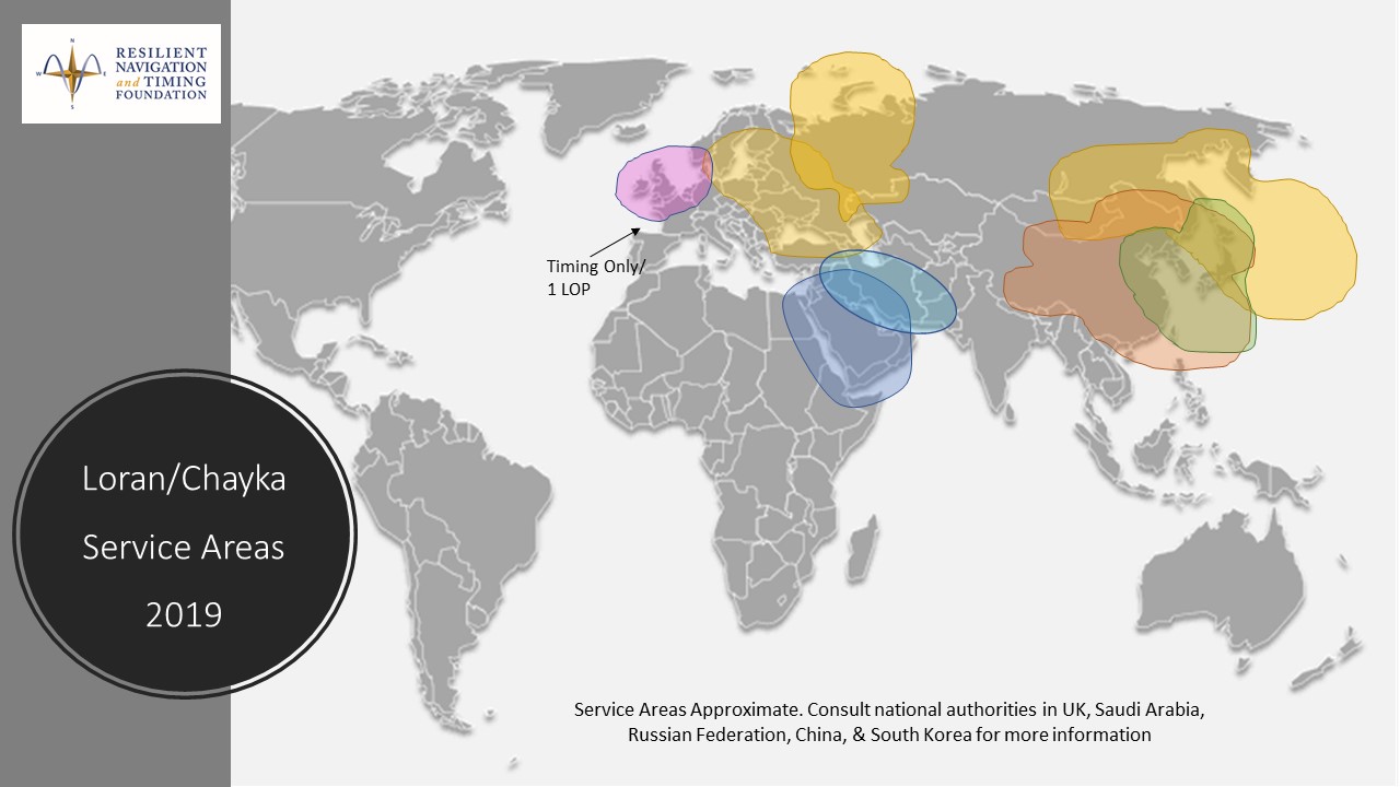
“The new signals seem incompatible with existing receivers and Loran networks,” according to Professor Jiwon Seo of South Korea’s Yonsei University. South Korea is upgrading its Loran-C network to the eLoran standard. The new South Korean system will be compatible with neighboring Russian and Chinese Loran systems, so users will be able to benefit from signals anywhere in East Asia. Until 2010 signals from the U.S. Loran system cooperated with these networks as part of the Far East Radionavigation Service (FERNS).
Navigation expert Logan Scott is intrigued by the proposal but observes that more work needs to be done. “This is an interesting waveform,” he said, though he had questions about the propagation channel, antennas, and possible distortion.
The authors acknowledge that much more needs to be done, including better determining timing and positioning accuracy.
Yet they and others see potential in combining the very different phenomenologies of low frequency, 100KHz Loran and 5G telecommunications which typically operate in the gigahertz range.
Opshaug and Tuck’s paper LORAN-5G can be accessed here.
An August 2020 paper published by the journal Sensors revealed China’s plans to expand coverage of its terrestrial Loran positioning, navigation and timing (PNT) system with three new transmitter sites in the western part of the country. The article indicates that this is a part of providing a backup system for GNSS.
According to the paper, “…the vulnerability of GNSS to unintentional and intentional interference signals can be found frequently nowadays. For national security and economic effectiveness, a reliable and complementary navigation system is needed desperately. The suitability of the Loran for a backup navigation system has been evaluated and reported.”
China has operated a Loran system for decades. While the system is capable of operating independently, its signals are also compatible with systems operated by South Korea and Russia. These are coordinated through the Far East Radio Navigation Service (FERNS) to ensure the systems are complementary and reinforce each other where coverage overlaps. The United States and Japan were also members of FERNS until they terminated Loran transmissions in 2010 and 2015, respectively.
Image: RNT Foundation
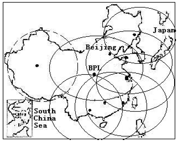
Little public information about China’s Loran system has been available and our queries have gone unanswered. One of the few documents available in the west is a 2014 paper about Loran-C from the Chinese Academy of Sciences in Shaanxi, China which can be accessed through the RNT Foundation website. It shows substantial Loran coverage in the eastern part of the nation, but only a broken circle indicating “projected coverage” in the west.
Graphic from 2014 Chinese Academy of Sciences paper on Loran showing projected coverage in the western part of the country with a dotted circle. (Image: RNT Foundation)
The single transmitter in that area projected by the 2014 paper could provide a strong, difficult to disrupt timing signal for fixed receivers with known locations.
Three new transmitters will be installed according to the August 2020 paper titled “High-Accuracy Positioning Based on Pseudo-Ranges: Integrated Difference and Performance Analysis of the Loran System.” The increased service in the western part of the country will provide “full coverage” positioning, navigation and timing usable by both fixed and mobile receivers.
The August 2020 paper is the first known documentation in over a decade of specific Chinese intentions regarding its Loran system.
Still, it is not a surprise to many observers. At 2019’s Stanford PNT Symposium, Xiaochun Lu of China’s National Time Service Center described the nation’s plan for a “comprehensive” PNT system. This system will include a wide variety of PNT sources including low earth orbit satellites, inertial systems, local positioning systems, and Loran.
Like Ms Lu, the authors of the August 2020 paper are employed at China’s National Time Service Center, which is part of the Chinese Academy of Sciences.
Not just supporting players, alternative positioning, navigation and timing (PNT) systems strengthen, augment and — when needed — replace GNSS. GPS World explores how companies are using alternative PNT, and talks with John Fischer of Orolia about the company’s latest developments.
GPS World: What are Orolia’s latest advances and products regarding alternative PNT?
John Fischer: Regarding timing, which we have been doing for decades, our big alternatives to GNSS are internal atomic clocks and network-based timing, such as precision time protocol (PTP). Regarding positioning and navigation, the two areas on which we focus are IMUs and getting updates from GNSS, so that, when you lose GNSS momentarily, you have something on which to coast. The breakthroughs in MEMS technologies are astounding —they are getting better and cheaper every day. That shows wonderful promise.
The other area is doing satellite navigation using low Earth orbit (LEO) satellites, which are much closer to the Earth than GNSS ones and give you 30 dB or more of signal strength. We are focused the most on the Satellite Time and Location (STL) signal because it is available today. Supplementing your navigation system with updates from LEO satellites provides you some great non-GNSS navigation capability.
GPS World: The positions of LEO satellites are not monitored as closely as those of GPS satellites. Is that an issue?
JF: That is correct. You are losing accuracy by using what is available today because you do not know the positions of those satellites as well as you know those of the GNSS satellites and maybe you do not have the best geometry. All the GNSS satellites are in medium Earth orbit (MEO) because they have much better geometries for a small constellation. With just 24 satellites in MEO orbit, you get great geometries. When you go lower, you need an increasingly greater number of satellites.
The first generation of LEO satellites, the Iridium STL, are a much larger constellation, with 66 satellites, but still not enough to give you the good geometries. Today, you are getting less accuracy, but there are all kinds of new satellites being launched and the capability to track them will improve. We expect to be able to use signals from hundreds, if not thousands, of LEO satellites, so the geometry problem will start to go away and there are other things we can do to improve the accuracy. Meanwhile, we can get rather good performance with what we have today.
GPS World: What are some of your most recent advances, releases or products?
JF: On the timing side we have what we call a mini-Rubidium, the mRO-50, which we launched on June 4. Smaller, better, cheaper atomic clocks are coming out very soon.
GPS World: Do you have any comments on the recent executive order on resilient PNT?
JF: We coined the term “resilient PNT,” so we are glad to see it in use. We fully support those efforts.
GPS World: What about other alternative sources of PNT data, such as radar, lidar and signals of opportunity?
JF: Yes, they are that next level. Loran is ideal because it is so different from GNSS. When you are trying to design a reliable system, you want a lot of diversity, because if two systems have the same kinds of failure modes you have not gained in redundancy. Loran is literally at the other end of the spectrum from GNSS: It is a low-frequency microwave system. Instead of being space-based, it is land-based; instead of being low power, it is high power. However, there still are no stations up. It requires big equipment, so it will take some time.
When it comes to what you can do today, Loran does not contribute much. We support efforts to implement Loran very much, because we do need non-GNSS ways to make things resilient. Prior to GPS, we had to depend only on Loran. Today, with modern digital signal processing (DSP) techniques and receivers, I think we can expect the new Loran system to have much better accuracies than we had in the bad old days of the first generation of Loran.
The auto industry is doing a marvelous job of doing navigation using lidar or cameras. They are pretty much navigating driverless cars the way that humans drive, by just using visual cues. Those things have promise in certain unique areas.
Europe’s scattered monitoring of GNSS signals found almost 500,000 interference events over three years. About 59,000 were clearly intentional. European standards for resilient receivers have been published and acquisition of an interference detection network is underway.
Russia is improving its terrestrial Loran/Chayka PNT system for military use and has promised to make the upgraded service available to civilians.
China has retained its terrestrial Loran PNT system as an augmentation/backup for its BeiDou GNSS. It is also testing PNT satellites in low earth orbit (LEO) to provide more powerful and reliable signals than available from current GNSS.
In contrast to the actions of other countries, little is being done in the United States to protect civilian GPS/GNSS users.
The U.S. Department of Defense (DoD) has been very active protecting its own with GPS M-code signals and receivers. It is exploring use of LEO communications satellites and high-powered, low-frequency ground transmissions, such as Loran, to add to the GPS signals.
Yet DoD claims civilian use of GPS has limited its ability to use it as a military tool. It says it has no intention of sharing any new PNT systems with civilians.
At the same time, the 99% of GPS use in the U.S. that is non-military is arguably more important to the nation’s safety and security. GPS signals are used by every networked technology and every mode of transportation. They are so important that officials at the Department of Homeland Security have called GPS “a single point of failure for critical infrastructure.”
The U.S. military recently updated its PNT strategy, has a designated leader for its PNT efforts, and clearly defines the responsibilities of its various staffs and organizations.
Civil agency responsibilities were last updated in 2004 and are spread across more than a dozen departments, agencies, and staffs.
Most significantly, no one is in charge.
This has meant that over the past 15 years, many of the civil mandates and responsibilities to protect signals and users have gone unfulfilled. As just one example, rather than ramp up to address increases in jamming, the Federal Communications Commission has reduced its enforcement equipment and staff.
Putting someone in charge is key to reversing America’s civil PNT decline and energizing both federal and private stakeholders.
A single, empowered federal leader should be responsible, not for doing everything, but for leading and coordinating federal and other civil efforts. This would be someone to be held accountable, and to hold others accountable — an evangelist for the essentiality of these services, and their advocate at the highest levels of government.
Such a leader should be positioned outside the daily turmoil of the White House and National Security Council. They should be in the civil department with the portfolio that most depends on GPS and other PNT. The one that suffers first when GPS and other PNT are not available — the Department of Transportation (DOT).
DOT is already the federal interface with civil GPS users, and co-chairs the national PNT executive committee with DOD. A few edits to national policy and a few staff reassignments could establish a national PNT leader in DOT and make all the difference.
Regaining U.S. PNT leadership is essential to America’s future security and prosperity. We must take the first step by appointing and empowering a single federal leader to make it happen.
The day started like any other day. The land surveying crew loaded up their vehicle, equipment and marching orders to tackle the next project on the list.
This field party is like most surveyors across the globe — they are equipped with the latest surveying technology including GPS base and receivers, robotic total station and a UAS for aerial photography. These tools are necessary to be competitive in today’s surveying arena as speed and productivity are paramount to the success of the project and the company.
But on this day, any device with the ability to determine geographic location via satellite reception was rendered useless.
Today became known as the day that GPS went away.
How we became dependent on GPS
Let’s back up the story to the introduction of GPS and how our dependency on this technology came to be. With the invention of satellites culminating with the Russian effort to launch Sputnik, the United States became involved in a “race to space.” Our early efforts to use satellites were proven worthy with the successful ability to track submarines by reception of radio signals and trilateration.
Further enhancements through research resulted in the development and creation of the NAVSTAR satellite in 1978. By 1993, 24 satellites were in orbit to make the GPS system fully functional (NASA.gov).
Meanwhile, the Russians were committed to a satellite network for navigational purposes during the same time period. The first satellite, Kosmos-1413, was launched in 1982 with the full 24 satellite constellation becoming operational in 1995.
Together, these systems (known as global network satellite systems or GNSS) allowed for location and navigation abilities never thought possible, and the surveying community began its adoption of the technology.
Early survey adopters of GPS were usually large engineering firms, state departments of transportation (DOTs) and federal agencies that could afford the large financial commitment to the equipment (both GPS and computers), software and computing costs required to use the technology.
The data-collection times were long, and the software analysis required enormous patience and extensive mathematical knowledge, but the results were beyond what the everyday surveyor had ever before accomplished.
Significant distances could now be measured with the same or better accuracy than taping or using an electronic distance meter could have provided. The true revolution came when real-time kinematic (RTK) GPS was invented and was affordable to the everyday surveyor (GPS World, May 2016).
S/A and A-S
Most GPS users, especially operators of survey-grade receivers, are not aware of the early days of satellite navigation and the military’s use of selective availability, otherwise known as S/A (GPS World, Sept/Oct 1990). This methodology was implemented by the Department of Defense (DoD) on May 25, 1990 to limit accuracies for non-military GPS users.
This procedure was created to allow erroneous timing at random occurrences throughout transmission of satellite radio signals. These variations in timing more than negatively tripled the normal precision of an autonomous GPS position calculation, all in the name of introducing uncertainty to potential enemy users.
And if S/A wasn’t enough, the DoD also could implement another deterrent called anti-spoofing (A-S) and encrypt the precision or P-code of the satellite signal. The big factor here is that the general public (in our case, the surveying community) didn’t know if or when A-S was turned on. These factors were frustrating to the GPS user, so data collection and coordinate determination became a tedious operation.
Early receiver use by surveyors relied on differential GPS data collection for high-accuracy location (<10 cm or better). This method consisted of placing one or more receivers on known positional points (usually on monuments published through the National Geodetic Survey) while simultaneously performing data collection on new points for positional establishment.
Prior to S/A, the software utilized to analyze and reduce the data collection provided feedback on “bad” data, but there were usually environmental issues causing the problem (such as cycle slips and radio interference.) The software would highlight the suspect data for the reviewer to determine validity and acceptance.
Because of the nature of differential GPS data collection, error checking remained the same once S/A was implemented. If the software calculated an incorrect coordinate at a known point, the same measurements to the new survey point were dismissed as a false reading.
Surveyors were mostly left unfazed by S/A as real-time kinematic (RTK) and real-time network (RTN) follow a similar procedure utilizing a correction from a known terrestrial point. Even with the anti-spoofing activated, the surveying profession continued to use this high-tech location system that revolutionized long distance measurement. Things have been running along smoothly with steady improvement of receivers, data collectors, and data coverage until…
The day it goes away
…the unthinkable happens. Our national satellite system is no longer available.
It doesn’t matter why GPS has gone away on this day. It could be for many different reasons: federal budgets; enemy interference such as geomagnetic disturbances (GMD) or electromagnetic pulse (EMP);
conventional or nuclear war; interference from solar storms, asteroids, or comets; or the system just simply breaks.
Artist’s rendering of a cross-section of the Earth’s magnetosphere. (IMAGE: NASA)
Another thing for all users of GNSS to consider in these tumultuous times is how newer systems are integrating other countries’ satellite networks into their navigational observations.
Our relationship with the Russian government can be on unsteady ground from time to time, so our use of their GLONASS signals must be reviewed for accuracy as well (See GPS World, August 2017).
It won’t matter whether a spoofed satellite signal originates from a private Russian hacker or from their actual government; it will still lead to incorrect information and bad data. Imagine having to revise a plat because the GLONASS data was purposely corrupted!
Obviously, the main reason they would allow transmittal of misinformation would be for military reasons, but I can only imagine their joy of messing with professional navigation and the recreational users in the U.S. These opportunities will also apply to the Chinese and Indian constellations, too.
We’re not ready
The bottom line is that we, the U.S., aren’t ready for it. Whatever may be the reason for the failure, we do not have a backup plan and have relied much too heavily on satellite navigation. Gone is our ability to navigate through our electronic devices, including smartphones, fitness trackers, in-car mapping and, yes, high-precision surveying equipment. These items have now become door stops and space wasters.
This new conundrum doesn’t just stop with the surveyor and recreational GPS equipment. A significant amount of construction equipment relies on machine control, from bulldozers and road graders to high-rise cranes.
This will also affect a large amount of agricultural equipment and processes. Those high-tech tractors with autosteer and computer-guided planters? Back to the drawing boards. So many things in our lives today are guided or controlled by navigational systems designed around GPS use, and the surveyor is squarely in this mix.
What’s a surveyor to do?
The first thought on the surveyor’s mind is now having to perform all surveying tasks with instruments that are not based on satellite navigation. Yes, the reason for this GPS shutdown isn’t widespread enough to affect cellphone signals and other radio communications, but it killed off the one navigation system more people rely on than any other.
Because of this unfortunate shutdown, all GPS-based equipment is now worthless. This means your trusty RTN receiver with cellphone connection, your old base unit for those times when cellphone coverage is lacking, the fancy new UAV for taking orthophotography, and your cellphone or handheld GPS receiver for tracking down NGS monuments — all of them are done. Only your conventional equipment will complete the job.
Is the surveying profession finished? How do we locate those remote section corners in the middle of nowhere?
Don’t throw in the towel just yet. Surveyors have been measuring land using these types of instruments for centuries, with today’s versions being electronic and sophisticated. Robotic servos, mini computer-data collectors, efficient radio links and active tracking prisms have turned our forefathers’ simple transit into a sophisticated topographic or construction staking machine.
Data collection is much easier than writing everything in a field book, and have graphical interfaces and remote connection capability to keep you in touch with the office from nearly anywhere. The reality, however, is that the surveyor will now have to use methods and equipment for traversing, data collections and all staking tasks that will greatly reduce our productivity and profitability.
Experience could also end up being a big factor here as well. The average age of the professional land surveyor in the United States is 58 and climbing. This means most of these practitioners have been in the business well before GPS technology, so there is still the potential of surveying without the electronic birds in the sky.
Surveyors can still hang their shingle and practice their craft, but we’ve now lost a big component of our world: geographical location. The key to the success of GPS was the ability to determine geographic location and subsequently convert that information into a data format compatible with one’s local system. From UTM coordinates to State Plane, the world became smaller with this technology.
The surveyor can still determine latitude and longitude using manual surveying methods for specifically observing the sun and Polaris. The mathematics and procedures are complicated, but they still allow for determining a geographical location with high accuracy.
We can also utilize the extensive geodetic monumentation networks established nationwide, all started around the formidable effort by the Coastal and Geodetic Survey. This key federal agency, later to become the National Geodetic Survey, laid the groundwork and set the monuments for the backbone of our national horizontal network system. This system has been augmented over the years by their own programs, as well as state and local authorities, to expand our coverage to all portions of the United States.
By incorporating these monuments into a survey, a relationship to geographical datums is still easily obtained. While these methods of establishing geographical coordinates through use of conventional equipment sounds time consuming, without GPS and other satellite-based navigational aids, it will become much more cumbersome.
So, what do we do next?
Depending on which industry you are in or your necessary level of accuracy, several alternatives are being developed. For those in the shipping industry (including the trucking sector, which numbers more than 15 million vehicles), accuracy may only need to be nominal — for instance, 5 meters, give or take.
Several systems are in development with the biggest priority on enhanced loran (short for “long range navigation”) or eLoran (also see GPS World April 2014 and GPS World Nov 2015). Several bills are currently being reviewed in the U.S. House and Senate for consideration of funding this technology.
These programs are still under development, but DARPA has been tasked with finding another system so our dependence on GPS will not cripple our defense in a time of war.
Abraham Lincoln, the county surveyor — a statue at Lincoln’s New Salem State Historic Site, Illinois.
Another alternative will be private satellite networks. With programs like SpaceX and Blue Origin, vehicles to carry new satellites into orbit are now a viable option. It will be possible for companies to create their own networks for private or commercial use.
With the large number of construction, shipping and automobile sales, the day may come when the navigation system within each of these is proprietary. However, if we are faced with geomagnetic disturbances (GMD) or an electromagnetic pulse (EMP) as mentioned earlier, it won’t matter whose network it is — they will all be rendered useless.
Until another viable option is created, the surveyor will be forced to take a step back in productivity and technology with conventional instruments. While not the most ideal thing, it will force the profession to retrain its entire workforce on procedures and methods that haven’t been regularly utilized for many years.
For some, it will be like throwing away the computer for a typewriter or the remote control for the television set. For others, it will be an opportunity to truly “follow in the footsteps” of past surveyors. They will understand exactly how their predecessors went about “running the lines” and completing a true boundary survey.
I, however, hope we don’t find ourselves in this situation, and that a suitable backup system or even a more advanced replacement for our antiquated GPS is invented soon.
But if the day comes and our GPS goes away, I’m guessing that surveyors not having their favorite locating device will be the least of our society’s worries. It will truly be a day that will live in infamy.
The Loran sites at Havre, Montana; George, Washington; and Fallon, Nevada, will continuously broadcast from 0900 (MST) June 20 through 1200 (MST) on June 30. The sites will operate on the 5990 rate but occasionally may operate at other rates.
Only the site at Fallon will operate as an eLoran site. The sites at Havre and George will operate as Loran-C sites synchronized to UTC.
For further information on eLoran, tune into the free webinar on June 15, “Alternative PNT Services.” One of the four presentations will be by Steve Bartlett, executive vice president of UrsaNav, who will provide a brief overview of eLoran technology and performance characteristics with a focus on timing in critical infrastructure applications. Other presentations will cover a new Satellite Time and Location service and indoor timing with a terrestrial beacon system.
UrsaNav is engaged in a Cooperative Research And Development Agreement with the U.S. Department of Homeland Security, the U.S. Coast Guard and Harris Corporation to research, evaluate and document eLoran technology as a candidate for providing position, navigation and timing (PNT) information. eLoran is being evaluated as a potential complementary system to GPS. UrsaNav believes that there is a potentially viable market, in both the public and private domain, for an alternative PNT service that is independent of GPS signal reception or which can be used in GPS-denied environments.
Texas company Continental Electronics has patented a transmitter system and method for construction of low-frequency antenna towers significantly lower in height than previously needed for identical coverage.
“One obstacle to deploying eLoran systems has been the sheer height needed for the transmission towers, each of which requires significant acreage,” said Mike Rosso, vice president of Dallas-based Continental Electronics. “Tower height and land required not only represent serious financial costs, but in some cases adequate space is simply not available. Our technology can reduce tower height and real-estate requirements. With this, reducing antenna tower height by half would reduce required land area to one quarter.”
The method uses digital adaptive correction, solid-state amplifiers, envelope modulation and a wideband matching network. Any linear distortions within usable bandwidth are removed by digital adaptive correction, according to the company. Envelope modulation is required to achieve linearization for any signal type including Loran. A wideband matching network tunes out capacitive reactance from electrically short antennas, transforms impedance to a value suitable for the transmitter, increases usable bandwidth and suppresses harmonics and out-of-band emissions.
“We hope this will aid moving forward eLoran deployments around the world,” Rosso added. “Widely used satellite-based navigation and timing services are vulnerable to jamming, spoofing and other forms of interference. The world needs a more resilient solution as afforded by ground-based solutions such as eLoran.”
An artist’s concept of a GPS IIR-M satellite in orbit (courtesy of Lockheed Martin).
For more than 41 years, many of us who were there in the beginning have been discussing the attributes, capabilities, enabling features and shortcomings of GPS and other space-based PNT (position, navigation and timing) systems. You have likely heard most of them; historically they go something like this:
The signal is weak.
The signal is easily jammed.
The signal can be spoofed.
The signal is subject to atmospheric perturbations.
The signal doesn’t penetrate buildings.
The signal doesn’t penetrate dense canopies (urban or natural).
I am sure you have heard most of these. Now, allow me to update the situation with some of the developments enabled by modern signals, new techniques, and multi-frequency, multi-GNSS (Global Navigation Satellite System) “all-in-view” receivers. All of the above bulleted statements are still true, but to a lesser extent, virtually each day. As some well-known pop musicians once sang, “It’s getting better all the time.”
Today, multi-GNSS signals in a fully modern multi-GNSS receiver can to some degree resist interference — intentional (jamming) or unintentional — and spoofing. It is extremely difficult for a jammer or spoofer to disrupt GPS, GLONASS, Galileo and BeiDou all at the same time. And more help is on the way.
Today, multi-GNSS signal corrections remove a large amount of error due to atmospheric perturbations and can sometimes deliver centimeter and millimeter accuracy in real time (in the case of short-baseline real-time kinematic (RTK) using only L1 carrier-phase as data, and/or in some other special situations.)
Today, multi-GNSS signals and augmentation signals show some improvement in penetrating dense canopies and canyons by virtue of their multiplied numbers and dispersed geometry.
Today, new ground-based technologies show promise at penetrating buildings to provide indoor location. When combined with GPS/GNSS, this is starting to get us closer to the Holy Grail, the ubiquitous PNT solution.
Debate
The future looks bright for PNT solutions, ground and space-based. I know it all sounds like a debating society, and you may have heard some of these arguments before. My point, my premise if you will, or bottom-line-upfront in military parlance, being: the GPS (space-based) limitations of the past are gradually giving way to the improved multi-GNSS capabilities of today and the combined ground-based and space-based PNT technologies of the present and rapidly arriving future.
Unfortunately, there are many uninformed so-called PNT pundits who love to posture for the press — and who are living in the past. The future is right in front of them, or in many cases in their hands, and they cannot or will not acknowledge its existence.
It’s all in the numbers
Current estimates are that more than 4 billion users depend on PNT daily for position, navigation and timing, or the multitude of services each of these resources enables. More than half of that number is attributable to smartphone users, which means, at a minimum, more than 2 million PNT users have a two-way communications device incorporated into their PNT receiver/sensor.
Let’s look at current high-end smartphones as examples of commercial multi-frequency, multi-GNSS “all signals available” devices. The user has a true multi-GNSS device incorporating:
GPS — Global Positioning System, United States government
GLONASS — Globalnaya Navigazionnaya Sputnikovaya Sistema, the Russian space-based PNT system
BeiDou — the Chinese BeiDou Navigation Satellite System, a regional system now, soon to be global (2020 the advertised date).
with augmentations such as
WAAS — U.S. Wide Area Augmentation System
EGNOS — European Geostationary Navigation Overlay Service
Other SBAS — additional Satellite-Based Augmentation System signals by region
Wi-Fi — Signals compatible with a set of broadband wireless networking standards.
The latest high-end smartphones incorporate an inertial system, a digital compass, a rate gyro, and a pressure sensor integrated with pedometer software that keep track of position, heading and velocity when external signals are lost. Add cellular tower and network-enabled positioning and timing technology, and you have a two-way communications and PNT-based multi-GNSS sensor that, as long as it has power, is never lost.
Atomic numbers
The rubidium-based (atomic-reference system) timing signals from GPS satellite vehicles (SV) are among the most stable timing frequencies ever broadcast from space. The true accuracy of the signal in space is classified, but approaches an accuracy 10 times better than what was once thought to be adequate for our warfighters.
The best clocks in any current GNSS system are the passive hydrogen masers of Galileo. Thus a PNT set-up that adds Galileo to GPS improves in more ways than one.
Ephemeris numbers
Twenty-five years ago, the U.S. military kept track of GPS satellite orbit locations (known as the ephemeris of the satellite) using actual GPS measurements at the control segment tracking stations. The GPS satellite ephemeris was known to a much lesser degree of accuracy than now. At the time, that accuracy was considered good enough.
Today, the ephemeris is known much more precisely, and this can be on the order of some centimeters. This has to do with not only the location of the satellite’s center of mass (c.o.m.), but the actual location from which the signal is broadcast. The position of the satellite’s broadcast antenna is known reasonably well most of the time, by very high-end users, after correcting for the arm lever between the c.o.m. and the antenna phase center. The c.o.m. itself can vary by some centimeters over time because of depletion of onboard expendables, but here we are getting into very high-order minutiae.
Suffice it to say that certain multi-GNSS scientific high-precision receivers today are used to measure tectonic movements on the order of centimeters over the course of a full year.
Number of signals
Just recently, with the addition of certain QZSS signals (the Japanese Quasi-Zenith Satellite System) along with the Indian (GAGAN) and Russian (SDCM) equivalents of WAAS and EGNOS, the number of multi-GNSS PNT signals available to a truly international multi-GNSS receiver exceeds 200. For example, one set of global commercial receivers routinely receive and process more than 190 PNT signals in a six-hour period. The receivers are both static and dynamic, and they are networked. The static receivers know their actual location to within millimeters, and use this location as a truth set from which all other signal data is compared.
Accuracy numbers
For our example (and all parameters are software-defined and user-programmable), the location parameter may be set at 10 centimeters, meaning that any position derived from PNT signals or augmentations that differ by more than 10 centimeters from the “truth set” are immediately rejected, and that data is broadcast on the systems network, which keeps the dynamic receivers in sync as well.
The individual receivers each contribute to their own and a networked website with metadata usable by Kalman filters to which other users may choose to subscribe. This makes the multi-GNSS receivers not only receivers, but system and PNT monitors and sensors that can detect jamming, interference and spoofing attempts, which are reported.
This monitoring and tracking system is constantly evolving and incorporating new technologies while becoming more secure everyday. This is not a totally new concept, as the core system is a mature enterprise system that has been in operation and commercially viable for more than seven years.
This should be comforting information for those of you who stay up at night worrying about the safety of autonomous vehicles on land, sea and in the air.
Don’t let me give you the impression that GPS is just waiting around for other GNSS to come to its aid. GPS is aggressively modernizing itself. In Air Force parlance, “GPS III space vehicles will introduce new capabilities to meet higher demands of both military and civilian users.” As stated by GPS III contractor Lockheed Martin, the modernized system will:
• Deliver signals three times more accurate than current GPS spacecraft.
• Provide military users up to eight times improved anti-jamming capabilities.
Augmentations and improvements
The bottom line is that a greatly increased number of space-based PNT platforms — along with quantum improvements in computing power, cheap non-volatile memory and software-defined capabilities — have produced a multi-GNSS PNT capability that increases availability via sheer numbers, with more security and reliability on the way.
A pair of LocataLite transmit antennas overlook a section of the White Sands Missile Range blanketed by the Locata high-precision ground-based positioning system.
We are rapidly developing a PNT system that goes far in countering the naysayers. It takes advantage of augmentations and complimentary systems such as newer versions of Loran, (Long-Range Navigation System) and local PNT implementations such as Locata, just to name a couple of examples.
These ground-based systems are critical to the future of PNT, and have very strong signals. For instance, eLoran is extremely difficult to jam, if not actually unjammable. If a monstrous sunspot were to temporarily knock out the majority of space-based systems, the ground-based systems would more than likely still be available, if — big if here — they are fully developed. At the moment, this is not a sure thing. It is a work in progress.
Ground-based augmentations and complimentary/backup systems can in the future add a level of security for GPS and other space-based PNT systems: Why bother trying to knock out these space-based systems when there is a suitable and readily available ground-based system as a backup?
The U.S. government maintains a number of monitor stations around the globe. However, it has not historically taken advantage of the incredible capabilities of multi-GNSS receivers and sensor technology. Although NASA and other U.S. non-military agencies have been involved with multi-GNSS — specifically the Russian GLONASS — for the past 20 years or so, the use has not been widespread. Fortunately, recent changes now permit multi-GNSS receivers for government users, including the military, in certain non-targeting activities, and the government would do well to take advantage of the changes. The good news is that the majority of the capability is in the receiver design, a capability on which the current director of the GPS Directorate at the Space and Missile Systems Center (SMC) “made his bones.”
To all those critics who take every opportunity to denigrate space-based PNT, both inside and outside the government, I say: Pay attention to multi-GNSS. Stop your diatribes, because the future is arriving. Secure space-based PNT systems are here to stay.
They continue to improve and become more secure as they incorporate space- and ground-based augmentations, new PNT technologies, software-defined capabilities, multi-GNSS signals, and enhanced computing. “It’s getting better all the time.”
Allow me to repeat myself all over again. Space-based PNT is here to stay.
Until next time, happy navigating, and remember: GPS is brought to you free of charge by the United States Air Force.
It happened in the blink of an eye. Less than a blink. Far less, actually. Slightly more than one one-thousandth of an eye blink, according to calculations. In that amount of time, one of your eyelashes traverses 10 micrometers on its journey toward your lower eyelid.
And yet it was long enough to throw computers and communications systems around the world out of whack, generate thousands of alarms, and pull engineers from their beds at 2 a.m.
One occurrence might have been enough to do all that. I’m not sure. But it kept happening over and over again. Thus the alarms, the out-of-whackness, the sleep deprivation. At least it did not generate massive financial trading sell-offs, blow holes in national security, or shut down Facebook, Instagram and Snapchat. For that, we may be thankful.
But it might have.
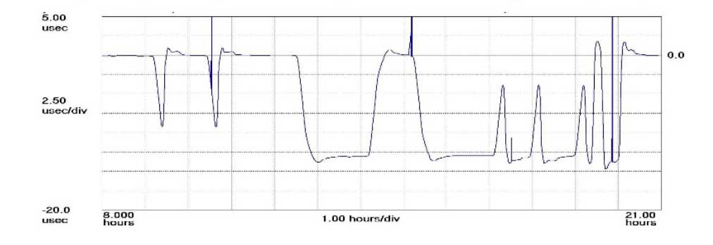
The plot shows how the anomaly event impacted one GPS timing receiver during the day. (Click to enlarge | Chart: Chronos Technology)
“On 26 January at 12:49 a.m. MST, the 2nd Space Operations Squadron at the 50th Space Wing, Schriever Air Force Base, Colo., verified users were experiencing GPS timing issues. Further investigation revealed an issue in the Global Positioning System ground software which only affected the time on legacy L-band signals. This change occurred when the oldest vehicle, SVN 23, was removed from the constellation. While the core navigation systems were working normally, the coordinated universal time timing signal was off by 13 microseconds which exceeded the design specifications. The issue was resolved at 6:10 a.m. MST, however global users may have experienced GPS timing issues for several hours.” (This excerpt from an U.S. Air Force communiqué appears in a brief news account.)
“The Joint Space Operations Center at Vandenberg AFB has not received any reports of issues with GPS-aided munitions, and has determined that the timing error is not attributable to any type of outside interference such as jamming or spoofing. Operator procedures were modified to preclude a repeat of this issue until the ground system software is corrected.”
Companies and their time-servers around the world were subsequently hit by up to 12 hours of system warnings after 15 GPS satellites broadcast the wrong time, according to Chronos, a UK-based time-monitoring firm.
Telecommunications companies constitute only a small part of industry users who rely on the highly precise accuracy of time measurements — supplied by GPS — to control data flow through their networks. Global financial networks and trading markets similarly depend on GPS, as do electrical power grids and many other sectors of critical national infrastructure. These companies and networks invest significantly in highly sophisticated equipment to monitor said timing accuracy as conveyed by GPS signals. Because billions, make that trillions — or actually even more — are riding on it.
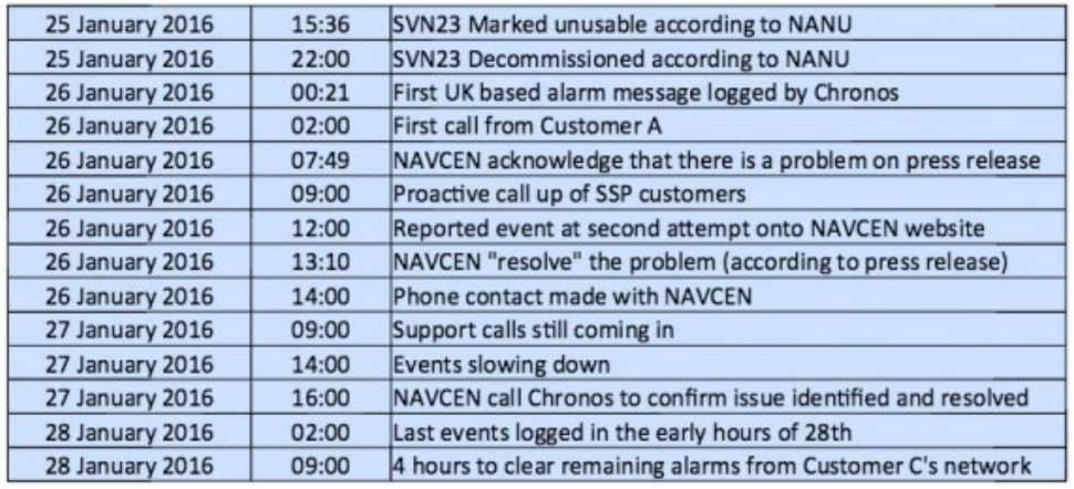
A week after the eye blinks, Chronos Technology released a white paper describing the ensuing fallout for its clients, who are timing equipment users in more than 50 countries around the world. Table 1 from the white paper reports the experience of a few during the event. One company registered nearly 2,500 alarms from its timing equipment during the outage.
Click to enlarge. (Table: Chronos Technology)
At one point during the crisis, according to the white paper, “it appeared that the GPS error had cleared and the Chronos SSP Manager was able to force the units out of holdover. However the scale of the problem escalated as these sites went back into holdover along with dozens of other sites suffering GPS-based timing issues. It was apparent at this point that there was something amiss with the GPS constellation itself.”
Later on, the report states, “This event linked to SVN23 has been one of the most significant service affecting issues for GPS timing users and sits alongside the April 1st 2014 GLONASS outage in scale — however its impact on global timing services is much more extreme.”
Ominously, “Chronos is aware of other more catastrophic impacts to networks and non-telecom applications which were not under supply and support contracts.”
As Loran Is Our Savior. At least one timing-reliant company was not disturbed by the problems, because it was testing an alternative timing service provided by enhanced Loran (eLoran) signals.
Unfortunately for them — and for the rest of us — eLoran has a very uncertain future. In fact, they were lucky to have an eLoran signal at all on January 26, because it was supposed to have been turned off on December 31. Somebody must have forgotten to tell the operators at the Anthorn giant antenna field in Cumbria to go home.
France, Norway, and the United Kingdom, three countries that had been keeping eLoran alive, officially abandoned the effort at the end of last year, reportedly because of lack of leadership from the United States.
The U.S. government decommissioned all its Loran stations a few years ago, even going to the extent of blowing some of them up (perhaps to prevent them from falling into the hands of subversives). Despite a recent reinvigorated interest in enhanced Loran technology, it may be too little, too late.
Whoa, Nellie. The first recorded use of the term “back-up technology” occurred in 1892, when farmers were urged not to prematurely abandon their mules in favor of John Froehlich’s new gasoline tractor.
Dan Albone on his prototype Ivel Agricultural motor. (Image: North Bedfordshire Gazette, 1903)
That admonition, however prudent, has since passed from view. But the concept remains sound. It has surfaced many, many times in GPS World magazine. Certainly not the first incidence, but the farthest back that I can retrieve via search on our website, came in 2007 from Defense contributing editor Don Jewell. “Why do we need a backup? Here is a classic case in point.” He describes a Joint Navigation Conference briefing on a surprise jamming incident that had occurred in January of that year.
In 2009, we reported on an Independent Assessment Team (IAT) report that “unanimously recommends that the U.S. government complete the eLoran upgrade and commit to eLoran as the national backup to GPS for 20 years.” The report was written in 2007, but quashed by the Department of Transportation and Department of Homeland Security (DHS) Executive Committees that commissioned it. Its public release came only after an extensive Freedom Of Information Act (FOIA) battle.
The U.S. government proceeded, despite its paid experts’ recommendations, to blow up those old Loran stations. The current renewed interest and the Wildwood experiment are worthy — more than worthy. Can they prevail? Can they survive blind reliance on a single string of vulnerable technology?
Indubitably, the critical role of GPS back-up was advanced prior to 2007, I just can’t document it this morning by deadline. For the sake of argument, let’s take April 12, 2007, as our start.
We are now 3,229 days out. That’s 77,496 hours, or nearly 279 million seconds. Correct me if wrong, but that appears to make 21.5 million-million times the length of January’s GPS timing error. Surely sufficient to blink a few times, scratch one’s head, and wonder.
eLoran Antenna Park of 13, 200-meter masts at Anthorn, UK.
Readers of GPS World, its e-newsletters, website — and all interested PNT parties — are invited to register their opinion in the current poll at gpsworld.com/janpoll.
Should the U.S. government install a full eLoran network of broadcast stations to back up GPS in case of jamming, interference or other emergencies?
Yes.
No.
More study is needed before answering this question.
Don’t know.
Voters may enter their name in a drawing to receive a $50 gift card. Vote by Jan. 11, 2016.
Results will be published in the February issue of GPS World magazine.
Let us not exaggerate — nor prematurely announce — the death of a subsystem. However, the demise of the U.S. Nationwide Differential GPS (NDGPS) network can be confidently foretold. Although a Federal Register notice dated Aug. 18 merely seeks public comment on plans to shut down a large portion of NDGPS, the handwriting is on the wall. Once having writ, the hand of fate moves on.
We should neither lament nor applaud. NDGPS, like many other technologies, has seen its time come and go, while competitors have arisen to perform its role and take its place. Such is evolution in the industrial world as well as in the biological kingdoms.
In 2016, three quarters of the currently operating NDGPS reference stations will be taken down and decommissioned. That’s not what the federal notice states, but that’s what it effectively says. The document’s comment period ends on Nov. 16. It is difficult to conceive of a public outcry that might reverse the intended course of the U.S. Coast Guard, Department of Transportation and Army Corps of Engineers.
The NDGPS network had its birth in the 1980s, as a tool to provide real-time positioning accuracy for harbor entrances and coastal navigation. Inland components were added over the years to improve river navigation, NDGPS use in precision agriculture began to grow, and a role in railroad positive train control (PTC) was much discussed. But all these efforts could not gather enough momentum to firmly establish the network’s viability. Meanwhile, satellite-based differential services from both commercial providers and the U.S. government’s own Wide Area Augmentation System (WAAS), and a network of continuously operating reference stations (CORS) from the National Geodetic Survey continually nibbled away at NDGPS’s potential customer base. Consequently, industry fielded a meager range of radiobeacon DGPS receivers.
The real death blow came in 2013, when the Federal Railroad Administration (FRA) eliminated an NDGPS requirement from its PTC program. The railroads, never a nimble industry nor one receiving the governmental support it enjoys in other countries, had by that time become the last hope of NDGPS. Ag users had already for the most part moved over to WAAS and commercial SBAS providers. Marine users did not by themselves form a sufficiently large constituency, and even they were not fully equipped nor wholesale adopters of the system.
The story of Loran bears some similarities to NDGPS, but Loran now enjoys a resurgence that NDGPS will never see. It is destined for the technological graveyard. There is an ecosystem of positioning, navigation and timing (PNT) tools and applications. Operating in a free market, with some measure of governments’ interference and manipulation, it has its own patterns of natural selection. We will continue to see the rise and fall of species. NDGPS has now been branded a dinosaur. It will be interesting to see how other technologies, competing for the same finite range of resources, will interact, thrive, or decline.
A bi-partisan group of legislators led by Congressman John Garamendi (D-Calif.) has introduced a bill that would require the U.S. Secretary of Defense to establish a backup for GPS within three years using eLoran.
The National Positioning, Navigation, and Timing Resilience and Security Act of 2015, H.R. 1678, was co-sponsored by Congressmen Duncan Hunter (R-Calif.), Peter DeFazio (D-Ore.), and Frank LoBiondo (R-N.J). Garamendi is the ranking member of the House Transportation and uInfrastructure Subcommittee on the Coast Guard and Maritime Transportation.
H.R. 1678 would require the secretary of defense, in coordination with the commandant of the Coast Guard and the secretary of transportation, to establish and sustain a reliable, land-based positioning and navigation system that will complement and backup America’s GPS for military and civilian uses by using eLoran.
eLoran is the government’s existing and underused long-range navigation system infrastructure. The backup system would step in when GPS signals are corrupted, degraded, unreliable, or otherwise unavailable. A terrestrial-based system, eLoran wouldn’t be affected by atmospheric interruptions such as solar storms, or jamming or spoofing aimed at GPS.
The bill directs the secretary of defense to incorporate the expertise and contributions of the private sector to quickly establish system architecture, as well as build and operate the system.
“GPS is much more than a LCD screen on your dashboard. It’s a technology used for much of our nation’s critical infrastructure and by almost every major industry in America, as well as the military, law enforcement, and first responders,” Garamendi said in a press release. “We are increasingly reliant on the precision, navigation, and timing services that GPS provides. From land navigation on cell phones to a timing source for our national infrastructure, we need a reliable backup system to GPS.”
Garamendi said the bill would make the nation’s geopositioning infrastructure more resilient to “threats both natural and nefarious.” “A backup system could also reach places that GPS currently cannot, such as inside many buildings. This would help first responders and law enforcement more effectively protect the public,” he added.
Other members of Congress are expected to sign on as co-sponsors after Congress returns from its spring recess, according to Dana A. Goward, president and executive director, Resilient Navigation and Timing Foundation.
The eLoran PNT system would use enhanced long-range signals (eLoran) from 19 towers around the country, each with approximately a 1,000-mile range providing overlapping fields from which a device can derive its location. The back-up system would use the remaining Loran infrastructure and provide a secure and reliable cybersecurity insurance policy, said the press release.
The U.S. atomic clock, accurate to one second in 300 million years, also serves as the base timing source for this backup GPS capability. This exceeds the timing needs of modern cell phones, creating an infrastructure backbone that is prepared to handle the evolution of consumer and industry electronic communications in the years ahead, the press release said.
The bill sets out numerous requirements for the system, saying that it shall:
Be wireless, terrestrial, and wide area
Provide a precise, high-power 100 kilohertz signal
Be resilient and extremely difficult to disrupt or degrade
Be able to penetrate underground and inside buildings
Take full advantage of existing, unused Loran infrastructure
Work in concert with and complement any other similar positioning, navigation and timing systems, including eLoran.
Since 2004, the federal government has recognized that the absence of a reliable backup system for GPS is a glaring economic and security threat to the United States, and has reaffirmed its interest in developing an eLoran as a reliable, land-based backup for GPS signals, the press release said.
In January, the United States Army began soliciting information for eLoran receivers for the warfighter, either stand-alone or integrated with GPS, for use in Army and other Department of Defense maritime, aviation, or vehicular platforms, and for position and timing.
The United Kingdom began using eLoran in October 2014 to protect its shipping lanes, which carry 95 percent of UK trade, in case of GPS signal loss.