Wingtra shares advantages of using its WingtraOne vertical-take-off-and landing (VTOL) drone at Intergeo 2018 in Frankfurt, Germany. The surveying drone offers large coverage, high resolution and accuracy down to 1 centimeter.
Background image: iStock.com/imaginima; B-roll footage courtesy of Wingtra
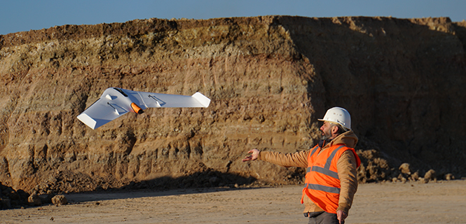
The UX11 is a lightweight, beyond-visual-line-of-sight (BVLOS)-ready fixed-wing mapping drone.
The combination of on-board processing capabilities, real-time control and centimeter-level precision make it a cost-effective solution for large area surveying and mapping, Delair said.
The Delair Septentrio UX11 mapping UAV. (Image: Septentrio)
By employing the latest high-specification photographic, sensor and communications elements, Delair has kept the weight of the UX11 — including payload — down to 1.4 kilograms (3.1 pounds). Among other design innovations, this allows the UX11 to cover 200 hectares (500 acres) in a single one-hour flight, delivering mapping with ground sample distances below 1 centimeter per pixel (0.4 in/px) with accuracy down to 1.27 cm (0.5 in).
A 3G/4G network link to the UX11 allows the operator to assess in real time the quality and overlap of images during flight and make any necessary adjustments to the settings of the integrated camera. This enables operators to collect as much aerial intelligence as possible in a minimum number of flights.
The UAV also features BTOL (bird-like take-off and landing) for steep-climb take offs and descents in confined areas.
The AsteRx-m2 delivers high-precision multi-frequency quad-constellation GNSS measurements for PPK (post-processed kinematic) for only 28 grams, and consumes very little power.
The combination of high-quality camera images and GNSS measurements from the AsteRx-m2 allows Delair to offer its users PPK survey-grade ground precision down to 1 centimeter. With Delair’s PPK software, powered by Septentrio’s GeoTagZ PPK library, users only pay for the precision they need and on a flexible pay-as-you-go basis.
“With the AsteRx-m2, we can offer wide-area coverage at ultra-high precision,” said Chase Fly, geospatial product manager at Delair. “The Delair UX11 sets a new standard of efficiency, cost and quality in a long-range UAV platform. The drone itself is truly state-of-the-art in its design and construction, and it enables industry-leading performance and flight range, as well as streamlined maintenance, advantages that all reduce costs.
“The integrated processing capabilities are able to ensure image quality in real time and provide users with accurate results that shape critical operational decisions and strategies,” Fly said. “And it’s designed for flexible use in a variety of conditions and use models, further lowering TCO.”
The AsteRx-m2 features Septentrio’s proprietary GNSS+ suite of positioning algorithms to convert difficult environments into good positioning:
LOCK+ technology to maintain tracking during the heavy dynamic vibration typical of UAV flights
APME+ to combat multipath
IONO+ technology to ensure position accuracy during periods of elevated ionospheric activity.
The AsteRx-m2 also features AIM+ interference mitigation and monitoring system that can suppress the widest variety of interferers, from simple continuous narrowband signals to the most complex wideband and pulsed jammers.
AIM+ can diagnose self-interference from other electrical or electronic devices onboard the UAV as well as mitigating external interference during operational flights.
“Driven by the explosion in the number and variety of drone applications, drone technology has advanced leaps and bounds in recent years and Delair have been right at the heart of the action. With their focus on innovation and a commitment to providing the very highest quality products, Delair and Septentrio are true kindred spirits and we’re proud to be part of the UX11 project,” said Gustavo Lopez, product manager at Septentrio.
Wingtra has officially launched the WingtraOne PPK high-precision mapping drone. Wingtra said its drone, which features vertical take-off and landing, is designed to set a new benchmark for large-scale surveying and mapping applications.
WingtraOne PPK offers large area coverage, ultra-high accuracy and brilliant image resolution. It features an advanced PPK module and high-quality cameras like the 42-megapixel full-frame camera Sony RX1RII, it is now possible to reach down to 1-centimeter absolute accuracy in aerial mapping.
To prove this accuracy claim, the Wingtra team performed test flights in a gravel quarry. The process was documented and is now explained in a white paper on the company website.
Conventional drone mapping on centimeter accuracy requires ground control points (GCPs) to correct the final map. Besides requiring additional surveying equipment and being extremely time consuming, setting up GCPs might be downright risky or just not possible in the area of interest.
More advanced solutions achieve similar levels of accuracy by using GPS correction technology for the georeferencing of the aerial imagery: namely RTK (real-time kinematics) or PPK (post processed kinematics).
RTK requires real-time base station connectivity and corrects GPS signals during the flight, while PPK corrects them after the flight and therefore offers greater robustness and consistency.
Moreover, PPK is independent from base stations or base station networks. It is highly reliable, accurate and time saving to use, Wingtra said. Neither special flight preparations nor intensive post-processing steps are required to achieve down to 1-cm accurate aerial maps.