Ness Czech will supply the Czech Railway Administration with a Digital Technical Railway Map (DTRM) with help from Hexagon’s Safety, Infrastructure and Geospatial division. The DTRM project has been underway since September 2022 and will be implemented by 2025.
DTRM is a railway-specific geographic information system (GIS), that provides access to transport and technical infrastructure information to better prepare investments and repair work. The basis of the DTRM project is the Technical Map Information System (ISTEM) developed by Ness and Hexagon.
The project includes digitization and consolidation of all available Czech Railway Administration data, covering more than 9,200 km of tracks, 27,000 km of technical infrastructure and an area of 21,000 ha. The delivery also includes three data centers.
The project is a legislative obligation of the Czech Railway Administration as the state is developing a national map, which will be fully operational by 2024. The Digital Technical Map of the Czech Republic is being built across the country by connecting regional digital maps, maps from the Railway Administration and maps provided by the Directorate of Roads and Highways. The connection is provided by the Czech Land Surveying and Cadastral Office.
Sixty-two of the first iteration of mounted anti-jam GPS devices were equipped into light armored vehicles in Germany over the past month, with thousands more scheduled to be installed into U.S. European Command vehicles by 2028, said Army leaders in charge of location data on future battlefields.
The Mounted Assured Precision Navigation & Timing System — known as MAPS — was developed to provide trusted positioning, navigation and timing (PNT) to a platform, such as Stryker vehicles, by pairing a GPS receiver with an anti-jam antenna, said Col. Nickolas Kioutas, PNT project manager.
Read more about MAPS, along with other anti-jam systems, here. Also look for our anti-jam feature coming in the December issue of GPS World magazine.
The electronic technology comes amid the Army’s vision for 2028, to best prepare soldiers for possible warfare with near-peer competitors, who have used electronic warfare to disrupt communications vital to Western forces in recent years.
This year, more than 300 Stryker vehicles, all from the 2nd Cavalry Regiment, are expected to be fielded with MAPS technology, said Willie Nelson, the director of the Army’s Assured PNT Cross-Functional Team.
Upgraded first-generation and second-generation technology is also expected to be unveiled in the future.
The Army also plans to equip armored brigades with the technology, and put MAPS in vehicles such as the Bradley Fighting Vehicle, M1 Abrams tank, and the M109 Paladin self-propelled howitzer. After those “priority vehicles,” the Army will evaluate the mounted device in second-tier priority vehicles, Nelson said.
Soldiers from 2-2 Stryker Brigade Combat Team move out in their Stryker during their training rotation at the National Training Center on Fort Irwin, Calif., Sept. 2, 2019. (Photo: Sgt. Ryan Barwick/U.S. Army)
In the past, armored vehicles have used multiple Defense Advanced GPS receivers, known as DAGR devices.
MAPS replaces multiple DAGR devices with one “really good system,” said Kioutas. The new system uses a chip-scale atomic clock for timing, Selective Availability and Anti-Spoof Module, or SAASM, for GPS, and anti-jamming antenna to distribute PNT information.
In addition, future iterations of MAPS will include non-GPS sensors by fusing GPS with alternate navigation and timing technologies to ensure accurate PNT that soldiers can trust while operating in various threat or denied environments, according to a statement.
A single-point GPS also creates multiple practical benefits for soldiers, such as less maintenance and system key-failing, Kioutas said, adding many of his team’s decisions are based on Soldier feedback, because listening to them today helps prepare them for tomorrow.
Simply put, “MAPS continues to work whenever a GPS signal is weakened or compromised,” he said.
“This is the first technology equipping for the Assured Positioning, Navigation and Timing Cross-Functional Team, and one of the first for Army Futures Command,” Kioutas said.
Nelson noted that they’re “working in parallel with both mounted vehicles and dismounted soldier’s PNT gear.”
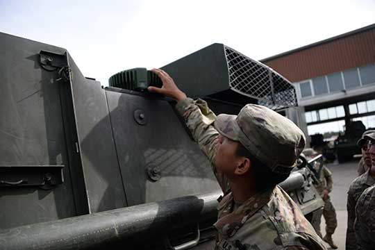
A soldier checks part of a Mounted Assured Precision Navigation & Timing System — known as MAPS. Sixty-two of the first iteration of mounted anti-jam GPS devices were equipped into light armored vehicles in Germany over the past month, with thousands more scheduled to be installed into U.S. European Command vehicles by 2028. (Photo: John Higgins)
Earlier this year, a requirements document for the dismounted soldier’s PNT was signed. Now, currently in the prototyping phase, the latest iteration of a dismounted GPS receiver can send secure PNT data wired or wirelessly, Kioutas said.
“A lot is happening here, a lot of good success,” Nelson said, adding, the most important thing for his team is to get the best equipment to “warfighters on the front lines and getting their feedback rolled back into the next generation.”
Nelson will host a Warrior’s Corner presentation Oct. 15 focusing on the PNT CFT’s Tactical Space Line of Effort, at the Walter E. Washington Convention center in Washington, D.C.
The U.S. Army will send prototype anti-jamming systems to its 2nd Cavalry Regiment, stationed in Europe, in September to aid forces under GPS jamming or spoofing conditions. The first generation of Mounted Assured PNT Systems (MAPS) and anti-jam antennas are nearly ready for integration aboard armored Stryker vehicles, and the Army is already evaluating proposals for an upgraded version incorporating an inertial navigation system (INS) for further resilience.
The shipment comes in response to widespread Russian jamming of GPS signals from the sub-Arctic to the Middle East, and in tacit, likely tardy acknowledgment of Russian superiority in electronic warfare.
An Interim Armored Vehicle “Stryker” and AH-64 Apache helicopters with Battle Group Poland move to secure an area during a lethality demonstration as part of Saber Strike 18 in June 2018. (Photo: U.S. Army/Spc. Hubert D. Delany III, 22nd Mobile Public Affairs Detachment)
Col. Nickolas Kioutas, Army project manager for positioning, navigation and timing (PNT), announced the move at the annual C4ISRnet conference in Arlington, Virginia. C4ISR stands for Command, Control, Communications, Computer, Intelligence, Surveillance, and Reconnaissance, or more broadly, electronic and other systems, procedures and techniques used to collect and disseminate information.
Three vendors are providing prototypes for the IMU-equipped second-generation MAPS, or MAPS-2, with testing to begin in September. A MAPS-3 capability, drawing on lessons learned in 1 and 2, may get underway soon. GPS Source, now a subsidiary of General Dynamics Mission Systems, made MAPS-1 and is now competing for MAPS-2.
The initiative reflects a new approach by the Army of “doing much smaller, iterative programs,” according to Col Kioutas. Traditionally, U.S. armed forces have taken years (and sometimes more years) to develop large, complex weaponry and supporting systems, and then even longer to deploy them. By the time they arrive in the operational theater, they are obsolete.
Rapid deployment of smaller, quickly designed and manufactured batches creates the opportunity for rapid feedback on what works and what doesn’t, with equally rapid return to the design board and re-manufacture. In other words, “shoot, aim, ready.”
Kioutas and crew are also flouting another U.S. military tenet, that in which previously “[we] asked for exactly what we wanted and industry built exactly to that. We don’t know exactly what we want. Tell us how we should do this the best, and then we’ll test that.” The PNT program has left requirements broad and open to change, knowing how quickly technology develops — and is shown to be vulnerable.
The Stryker is an eight-wheeled armored fighting vehicle, basically a lightly armored tank or heavily-armored troop carrier that is more road-friendly, that is, faster, than a tank. It has several variants of armament, armor and troop-carrying capacity. It saw extensive use in the Iraq counter-insurgency campaign.
East View Geospatial (EVG) is offering a new version of MapVault, a streaming service that brings together maps from around the world.
According to the company, MapVault provides access to more than 500,000 geo-referenced map sheets from more than 1,000 authoritative map series, which can save organizations the costs of procuring, storing and digitizing physical maps.
MapVault users have access to a diverse collection of topographic, aeronautical, nautical and geological map series sourced from international mapping agencies. Each series has been mosaicked for easy use and quick navigation. Robust metadata along with series index maps and individual sheet-level metadata are included.
New map series are added to MapVault on a regular basis, and subscriptions are customizable. Users can choose to subscribe to the series that cover their exact areas of interest or select from multiple regional package options.
East View Geospatial also provides custom series solutions and encourages users to contact the company about adding their own mapping resources to the MapVault platform.
MapVault was designed for a wide variety of users, both GIS and non-GIS specialists, and data is easily integrated into GIS software, the company said. The MapVault catalog can be accessed over the internet or through any WMTS (web mapping tile services) connection. Layer files formatted specifically for ArcGIS Desktop, QGIS, Global Mapper or other open-source GIS packages can be downloaded.
“What makes MapVault unique is the many advantages it brings to users,” said Kent Lee, president and CEO of East View Geospatial. “We’ve taken the time and cost out of tiling entire map series, giving users consistent, reliable data served up in a straightforward, easy-to-use streaming service. Whether you are interested in global or country-wide mapping coverage, or even county- or city-level mapping, MapVault gives users of all experience levels a simple and accessible environment in which to discover and utilize maps.”
Esri has published a Hurricane Irma Resource Catalog in advance of the Category 4 hurricane cutting through the Caribbean islands on its path toward Florida.
The catalog features read-to-use applications compiled by the Esri Disaster Response Program (EDRP). EDRP is an around-the-clock service that helps with monitoring events online, discovering useful content, augmenting software and obtaining assistance from Esri experts.
To see the track of the hurricane, Esri provides its hurricane map.
Resources include:
Hurricane Public Information Map (PIM)
Hurricane Impact Summary
Hurricane Force Wind Impact Summary
Storm Surge and Flooding
Storm Surge Inundation
Hurricane Evacuation Zones
Waze Alerts – Hurricane Irma
Florida 511 – Real-Time Traffic Information
Hurricane Irma Photo Story Map
Airport and Port Status
NOAA Real-Time Coastal Observations
Florida Division of Emergency Management Open Data
Waze alerts light up Florida highways as people evacuate. (Image: Esri)
Here there be dragons. That phrase (or a variation of it) was used by early mapmakers to designate the unknown — and alert sailors to the danger of traveling into uncharted waters.
I’ve always admired explorers who dared to push the boundaries of the known world. We’ve moved from the Age of Exploration to the Age of Information, but exploration continues on frontiers big and small.
Today, of course, most people think of the world as having been mapped. They can simply call up Google maps on their smartphone and see not only the world, but their town, their street and their house — in representational cartography (traditional map), satellite imagery, or even street-view imagery.
Professionals in geographic information systems (GIS) know better. The world is still a mystery in uncounted areas. For one thing, it’s not static: Volcanoes form new land masses, storms change coastlines, the sea-level is rising. For another, there’s more to exploration than a basic map.
That’s where the GIS professional takes center stage, assessing an area beyond what is already known, using a variety of tools to collect and analyze data. As Esri defines it, a GIS lets us “visualize, question, analyze and interpret data to understand relationships, patterns and trends. GIS benefits organizations of all sizes and in almost every industry.” A software-based profession, GIS experts use GPS, GNSS and inertial to gather data, which is where this magazine comes in.
At GPS World, we share GIS developments in our Mapping Market Watch, Mapping Launchpad and at geospatial-solutions.com.
“Smart cartography” is the top theme at the 65th Cartography Conference, which will take place Sept. 26-28 in conjunction with Intergeo in Berlin, Germany. Numerous examples at the conference and trade fair will reveal smart cartography’s wealth of potential.
The latest smart maps are as far removed from their 2D relatives on paper as is the state-of-the-art GIS platform from the analog planning basics of bygone years. But just what is so smart about these cutting-edge maps? Here’s a handful of examples of smart cartography.
Smart maps are intuitive and attractive
Maps have always been used to represent relationships and make sense of our surroundings. More often than not, they achieve this far better these days than ever before. Maps have become more accessible to their target groups and more intuitively understandable. You rarely need instructions on how to read a map nowadays. A prime example of innovative design is the widely discussed and highly praised new plan of Berlin’s public transport network. Architect Jug Cerovic uses his own special standard to translate complex public transport systems into both functional and aesthetically appealing maps. (http://www.jugcerovic.com/maps/inat-metro-mapping-standard/)
Smart maps provide customized information
Smart maps provide customized information right where it is needed. This might be the optimum route for mountain bikers or hobby cyclists (www.bikemap.net) or for navigating stress-free through the city using whichever mode of transport you like (https://wego.here.com/). While in the past, maps flattened reality into 2D, nowadays 3D is the norm. Not only that, but the fourth dimension of time is becoming increasingly prominent in digital maps. (http://360.here.com/2017/03/28/4d-mapping-can-change-world/)
Smart maps capture the moment – right now
Today’s smart maps are a dynamic product. They don’t lead to dead-ends, but instead simply keep on evolving. In the Internet of Things, where vehicles, mobile objects and sensor data gather and network millions of items of information, companies are working on creating living maps that constantly display real-time status. These form the basis for the self-driving vehicles of the future, on the streets and in the air close overhead. (https://here.com/en)
Smart maps reveal new insights
Whether you’re interested in commuter flows or refugee accommodation (https://www.findingplaces.hamburg/), smart maps are the number-one tool for planners and are now being used by politicians and citizens alike as the basis for political debate. The ability to explore visual representations turns raw data into a practical basis for making decisions. In Hamburg, for example, smart maps have become a game-changer in the search for locations for refugee accommodation and also help plot the most suitable corridors for projected commuter flows.
Multi-sensory maps
Click on a street to see how it sounds, at goodcitylife.org
Acoustic maps have been able for some time to visually represent “soundscapes” or add sound with the aid of audio files (http://www.life-dynamap.eu/). What’s new is the addition of olfactory elements. Researchers at Goodcitylife are working on capturing the “smellscape” of cities. And their Happymaps offer a completely new slant on the city – for those who are not as much bothered about getting from A to B as “enjoying the ride”. (http://goodcitylife.org/index.html)
Virtual and augmented reality
No one can fail to have noticed the craze whipped up by the AR application Pokémon Go (http://www.pokemongo.com/de-de/). This plainly revealed the potential that lies in virtually embellished maps. VR and AR map applications now liven up tours of museums and churches (http://dom360.wdr.de/) and are being used as planning and information tools.
I love maps. As a child, I was my family’s designated navigator on car trips (or my parents indulged me!).
I studied our roadmaps, searching out each legend icon on the map and finding icons to look up on the legend. I would use the map’s indicators to determine the distance between points and interesting landmarks. I was such a map fanatic, that I spent time one summer recreating in a large size a map of the Ancient Roman Empire. My father asked why. I had no real answer, except that I love history and maps.
Today, some experts are warning that our ability to read and interpret maps might be in jeopardy because of our reliance on GPS devices. Some GPS-reliant drivers make massive blunders, such as a Syrian truck driver who ended up in Gibraltar Point, England, rather than Gibraltar on the south coast of Spain.
Former president of the Royal Institute of Navigation Roger McKinlay told Vox reporter Brad Plumer that our reliance on GPS might be causing our innate navigational capabilities to atrophy over time, which is a problem when our smartphones will only ever be as “smart” as the humans using them.
“Neuroscientists have discovered that our brains have two different specialized systems for navigation,” Plumer writes. “In one system, located in our hippocampus, we create spatial maps of the world around us, understanding how different streets and routes fit together. In the second, located in the caudate nucleus, we make a mental list of the different landmarks we encounter every day.”
By not figuring out routes using maps, and relying solely on turn-by-turn directions, our ability to work out spatial maps and determine our place in the natural world seems to worsen.
“McKinlay argues that schools should teach students map-reading and navigation as a critical life skill,” writes Plumer. “He also suggests that researchers start looking at whether there are ways to design GPS systems so that they help us learn about our environment rather than making us unaware of the world around us. (It’s unclear what exactly this would look like, but what if, as a default, these systems always walked us through the spatial map of where we were going?)”
TomTom’s map and traffic information have been chosen by the University of Minnesota’s Accessibility Observatory as part of a new national accessibility data set.
TomTom will provide map and historical speed data to help analyze accessibility to jobs for driving and transit for metropolitan areas across the United States. For transit data, the Observatory is relying on open, public sources using a method developed at the University with support from the Center for Transportation Studies.
Study partners will be able to use this data for policy development, local transportation system evaluation, performance management, planning and research efforts. Each partner will have direct digital access to the accessibility datasets for the jurisdictions of all partners and will receive detailed reports of local accessibility trends and patterns. The Minnesota Department of Transportation is the lead agency and coordinator for the national pooled-fund study. Other participating agencies are the Federal Highway Administration (FHWA) and the DOTs of California, Florida, Iowa, North Carolina, Virginia and Wisconsin.
“Today’s transportation user wants more than mobility — they want accessibility and they want MnDOT to invest in the appropriate solution, at the right place, at the right time, and at the appropriate cost,” said Tim Henkel, division director of modal planning and program management at MnDOT. “The Accessibility Observatory offers solutions to these decision-making challenges.”
The Transportation Pooled Fund Program, part of the National Cooperative Highway Research Program, allows state DOTs, FHWA program offices, and other organizations to combine resources and achieve common research goals. Additional partners are welcome to join the study.
“We’re excited that the UMN Accessibility Observatory has selected TomTom to help provide geospatial and transportation information for this project,” said Ralf-Peter Schäfer, head of traffic at TomTom. “We are confident that the TomTom map and traffic content will contribute to a better understanding of job accessibility nationwide.”
TomTom has added navigable maps for 13 new countries. TomTom’s global map database now covers more than 45.6 million kilometers and 4.3 billion people worldwide, and features full navigable coverage for 134 countries.
“The addition of nearly 3 million kilometers of roads in one year demonstrates TomTom’s commitment to geo-expansion,” said Charles Cautley, managing director of TomTom Maps. “We rely on intelligent mapmaking and our transactional mapmaking engine to continuously deliver map updates around the globe, increasing coverage and improving map features for all business customers.”
Global map enhancements include:
The launch of navigable, turn-by-turn maps for Macedonia, Bosnia & Herzegovina, Peru, Guatemala, Nicarágua, Panamá, Costa Rica, Honduras, El Salvador, Iraq, Ghana, Rwanda and Burundi.
Introduction of Address Points to enable better geocoding and navigation in Austria, Luxemburg, Turkey and South Africa; significant growth in Address Point coverage for South East Asia reaching 3.6 million.
Significant Points of Interest growth in Mexico, bringing count to more than 3 million.
Launch of 3D Map for Singapore and the debut of visualization products for the Middle East, with an Advanced City Model of Riyadh and 2D City Maps for 15 cities.
AccuWeather App for Android Wear (PRNewsFoto/AccuWeather)
The AccuWeather app for Android is now available for Android Wear, providing users with up-to-the-minute weather information wherever they go. Android Wear is the Android platform for wearables such as smartwatches. The app is available through the Google Play store.
AccuWeather’s app for Android Wear features AccuWeather MinuteCast, a global minute-by-minute precipitation forecast for a person’s exact street address or GPS location. AccuWeather MinuteCast includes precipitation type and intensity, as well as start and end times for precipitation, and gives users by-the-minute precipitation forecasts for the upcoming two hours. The GPS technology that localizes the weather to the user’s location is protected by patents in the United States and many of the major countries around the world, AccuWeather said.
In addition to AccuWeather MinuteCast, AccuWeather for Android Wear and for Android smartphones and tablets provides users with severe weather alerts, hourly forecasts, and current conditions.
“This is an exciting opportunity for AccuWeather to deliver weather information in innovative new ways to users,” said Steven Smith, chief digital officer of AccuWeather, Inc. “As the global weather leader, we provide weather forecasts wherever, whenever, and however our users most want them. Easy access, hyper localization, ease of use, and the superior accuracy that is the hallmark of our organization, help our audiences everywhere make decisions and improve their lives.”
AccuWeather MinuteCast is available for the contiguous United States, Canada, Japan, Ireland, France, Germany, Belgium, Switzerland, Netherlands, Luxembourg, the United Kingdom, and parts of the Czech Republic, with additional locations to come.
AccuWeather for Android Wear, and for Android smartphones and tablets, is available from Google Play.
GPS World staff will be reporting from InterGeo October 7-9. The massive trade show, held this year in Berlin, is considered the world’s leading conference trade fair for geodesy, geoinformation and land management. With more than 16,000 visitors from 80 countries, it is one of the key platforms for industry dialogue.
Staff members attending include GPS World Editor and Publisher Alan Cameron, Survey/GIS Editor Eric Gakstatter, and Digital Editor Joelle Harms. All three are accepting meeting invitations for companies interested in discussing their products and services. Contact [email protected].
VIDEO PLAYLIST
PHOTOS
Photo: GPS World
Topcon demonstrates its LN-100W, an update to its line of 3D positioning systems designed for one-operator layout. Photo: GPS World
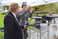
German-based Multirotor by servicedrone is a UAV for professional 3D orthography. Photo: GPS World
Attendees listen to a presentation on the show floor at InterGeo held October 7-9 in Berlin. Photo: GPS World
Attendees watch UAV demonstrations at the conference’s flight zone. Photo: GPS World
Attendees take a look at one of the many UAVs seen at InterGeo 2014 in Berlin. Photo: GPS World
German-based Moskito GIS GmbH displayed a model from its 5 Power GIS. Photo: GPS World
BRS Motorsport Formula Students from Bonn-Rhein-Sieg University of Applied Sciences showcase their simulator, sponsored by CPA ReDev. Photo: GPS World
Riegl debuted and demonstrated its RiCOPTER UAV with LiDAR Integration. Photo: GPS World
At dusk the night before the conference the moon overlooks the Brandenburg Gate, an 18th century arch in Berlin and one of its most well-known landmarks. Photo: GPS World
Summary: UAVs (unmanned aerial vehicles) are taking over the surveying industry, thanks to their ever-improving sensors and the fact that they are getting lighter and can therefore remain in the air for longer. They complete surveying and inspection tasks that would otherwise be difficult to tackle, and do so with impressive cost-efficiency. UAV trends and technology will be among the focal points at the InterGeo conference in Berlin in early October.
Our correspondents will return with a fresh report, moderated by GPS World Editor and Publisher Alan Cameron and Survey Scene Editor Eric Gakstatter.


 By Tracy Cozzens