savvy navvy has partnered with ProtectedSeas to bring ProtectedSeas Navigator data to boaters through the savvy navvy app.
After eight years of research and development, boaters and watersport users worldwide can now have access to comprehensive data and resources of ocean regulatory information, including marine protection areas, through the savvy navvy app.
ProtectedSeas Navigator provides boaters with 22,000 marine protected and managed areas in more than 220 countries. These areas include speed-limit zones to protect marine mammals, fisheries management areas and more.
ProtectedSeas compiles marine protection information into the Navigator database of marine protected areas (MPAs). It collects both large and small amounts of data and created the first public digital maps for more than 2,400 areas.
savvy navvy – often referred to as ‘Google Maps for boats’ – is an award-winning boat navigation app. It integrates multiple sustainable data sources from different conservation agencies and bodies.
Since launching its first global view of marine life protections, ProtectedSeas has been complimented by several industry-renowned leaders and bodies, including the U.S. National Oceanic and Atmospheric Administration (NOAA), Dr. Sylvia Earle, American marine biologist and oceanographer, and Gavin Newsom, governor of California.
Some ProtectedSeas data is already available in the savvy navvy app, with more to follow soon. Click here to learn more about the sustainable data or to download the app.
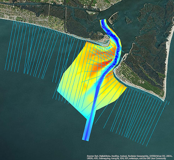
Multi-beam bathymetry and topo/bathy beach profiles of the Cape Fear River Inlet (USACE Wilmington). (Image: NV5 Geospatial)
Following its March 29 acquisition of Geodynamics LLC, NV5 Geospatial has built a comprehensive suite of solutions for geospatial surveys of deep-water and near-shore environments. Geodynamics will operate as a wholly owned subsidiary of NV5 Global as part of the NV5 Geospatial group.
The acquisition brought together complementary, advanced technologies — Geodynamics’ full ocean-depth sonar-based hydrographic and geophysical surveying with NV5 Geospatial’s topographic and bathymetric capabilities. Together, the technologies deliver detailed insights for a variety of applications, including coastal management, flood monitoring, ecosystem protection, research and more.
“This acquisition was a natural evolution toward our common goal of delivering valuable geospatial insights to our clients,” said Kurt Allen, vice president, Federal Vertical for NV5 Geospatial, powered by Quantum Spatial. “Our decades’ of combined experience and expertise using the most sophisticated technology for data acquisition and analysis will enable us to meet the most demanding client requirements.”
Geodynamics is a pioneer in collecting and processing single-beam, multi-beam, sidescan, geophysical and acoustic backscatter hydrographic data in some of the most challenging coastal environments, including dynamic tidal inlets, high-energy surf zones, and rapidly changing shoal systems that challenge navigation.
Geodynamics has completed large-scale hydrographic survey projects in the coastal and adjacent ocean areas of the entire United States, including detailed hydrographic surveys to support federal nautical chart updates in the Atlantic, Gulf of Mexico and Great Lakes region for the Office of Coast Survey of the National Oceanic and Atmospheric Administration (NOAA).
With a research focus on coastal geology, Geodynamics’ offshore geophysical surveys have supported mapping of marine minerals, benthic habitat and identification of potential submerged archaeological resources.
The relationship between the companies began with a joint venture in 2019. Working collaboratively as MarineGeoSpatial LLC, the partnership provided aerial- and ship-based remote sensing for offshore/marine survey and data collection, mapping and data analysis, and marine enterprise GIS services.
“We are excited to embark on this new chapter with NV5,” said Geodynamics CEO Sloan Freeman, PLS. “It is the perfect strategic alignment of aerial, subsea survey and geospatial services. Together, we have the technology, tools and experience to provide the best solutions to our clients and continue to advance scientific knowledge about coastal environments.”
TCarta Marine LLC of Denver, Colorado, has merged with Proteus Geo of Oxford, England, to create a global mapping company that provides bathymetric and marine data sets from the shallow coastal zone out to the continental shelf.
The new company is called TCarta Marine and will maintain offices in Denver and Oxford.
“By merging, we believe the merged company provides a wider and more sophisticated range of products than any other supplier worldwide,” said TCarta Marine CEO David Critchley. “TCarta Marine is now a one-stop shop for bathymetric and marine data.”
Image: Proteus Geo
TCarta Marine will continue offering all existing product lines from the two companies, as well as new products and services under development. Primary markets served will be engineering, oil and gas, government and defense with expansion planned into the insurance, 3D modeling and aquaculture industries.
“Our goal is to make it easier for the marine community to obtain and use quality mapping data,” said TCarta Marine President Kyle Goodrich. “To support every phase of offshore projects, we now offer lower resolution bathymetry for regional planning as well as high-resolution, highly accurate seafloor modeling for precise coastal engineering activities. Additionally, we offer a range of global and regional marine basemaps.”
In recent years, TCarta Marine and Proteus Geo collaborated on many projects and had numerous clients in common due to the complementary nature of their product lines.
David Critchley established Proteus Geo in the United Kingdom in 2011 to leverage a new technology that derives high-accuracy seafloor survey and seabed classification information from multispectral satellite imagery. Operating at a fraction of the cost of traditional ship and airborne bathymetric technologies, the Proteus methodology has been deployed extensively in energy exploration, infrastructure engineering and environmental applications in shallow-water coastal zones.
“The two-meter satellite-derived bathymetric data can be derived to depths of 35 meters depending on water clarity and every depth has an uncertainty value assigned,” said Critchley.
TCarta Marine was started in 2008 by Kyle Goodrich to fill an enormous gap in quality bathymetric data from the littoral zone out to the base of the continental shelf, distance often spanning hundreds of kilometers. The firm developed proprietary techniques for aggregating seafloor depth data from numerous medium- to coarse-resolution sources, including navigation charts, ship tracklines, and boat surveys. TCarta Marine has built an off-the-shelf line of 90- and 30-meter GIS-ready products covering the Earth’s most important marine areas.
“Our bathymetric products are available via annual subscription for streaming directly into our clients’ GIS and mapping applications,” said Goodrich. “Oil, gas and renewable energy companies have become major users of TCarta Marine products.”
As president of the new TCarta Marine, Goodrich will focus on developing additional products and innovative methods for delivering them. The global company seeks to expand its foothold in traditional marine markets and cultivate new applications for seafloor data. Critchley, as CEO of TCarta Marine, will be responsible for business development in new geographic regions of the world.
In the near term, TCarta Marine and Proteus Geo customers can look forward to purchasing the existing 90-, 30- and 2-meter resolution product lines online through a new web portal, now under development. Information can be found and orders placed now through the new unified TCarta Marine website at www.TCartaMarine.com.
Proteus FZC, an affiliated company of Proteus Geo based in the United Arab Emirates, will remain a stand-alone company offering terrestrial geospatial and marine consulting services in the Middle East.