Tag: maritime surveillance

  • Seen & Heard: Moscow taxis hacked, Norway turns to radar

    Seen & Heard: Moscow taxis hacked, Norway turns to radar

    “Seen & Heard” is a monthly feature of GPS World magazine, traveling the world to capture interesting and unusual news stories involving the GNSS/PNT industry.


    Photo: Space Norway
    Photo: Space Norway

    Norway to get radar assist

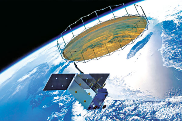
    Norway’s sea areas are seven times larger than its land area. Now the country is creating a radar satellite system to surveil and locate ships in waters of interest, including the High North. On Aug. 25, Space Norway signed contracts with vendors to build the MicroSAR system, which will launch in 2025. Plans are to make a constellation of radar satellites that can detect small vessels in a large area simultaneously. While the system will use GNSS for orbit tracking, the radar function is independent of GNSS during acquisition. This will solve a flaw in the Automatic Identification System (AIS) now used for maritime surveillance — estimates are that 5% of vessels either do not send out AIS information or are transmitting false information.


    Photo: Yandex
    Photo: Yandex

    Russia’s driverless autos hit the brakes

    Russian driverless projects are facing hurdles following the invasion of Ukraine, reports TU-Automotive. For instance, Russian IT giant Yandex had hoped to launch robo-taxis in the United States but has suspended street tests and robotic delivery pilots and laid off employees in its U.S. office. Russian freight carriers are experiencing a shortage of new vehicles and spare parts from Western trade sanctions and countermeasures by the Russian government. Meanwhile, Russia’s pilot tests of connected road infrastructure are still taking place, according to V2X vendor Sreda Software Solutions.


    Nathaniel Frissell and team. (Photo: University of Scranton)
    Nathaniel Frissell and team. (Photo: University of Scranton)

    Bunches of grapes

    A University of Scranton collaborative research project will use daily Doppler shift receiver measurements to study how dawn, dusk and solar eclipses affect the ionosphere. The team, led by Nathaniel Frissell, will use a network of GNSS-stabilized and synchronized high-frequency receivers known as Grapes, developed as part of another National Science Foundation project in 2019. The last solar eclipses to traverse the continental United States until 2044 will occur Oct. 14, 2023 and April 8, 2024. “This project takes advantage of the unprecedented opportunity to study the ionospheric impacts of the 2023 and 2024 solar eclipses and the daily ionospheric variability associated with dawn/dusk transitions,” Frissell said. A better understanding of the effects of ionospheric disturbances is imperative, because the changes affect GNSS navigation and communications systems.


    Screenshot: Anonymous TV
    Screenshot: Anonymous TV

    Moscow navigation fail

    The hacker collective Anonymous managed to disrupt Yandex’s Moscow taxi fleet on Sept. 1, sending dozens of taxis to an address on Kutuzovsky Prospekt. The hacking caused a two-hour traffic jam in the center of Moscow near the Stalinist-era building Hotel Ukraina (Hotel Ukraine), now a Radisson. Hackers likely bypassed Yandex’s safety measures, creating multiple fake orders that prompted drivers to simultaneously go to the same location.

  • Tekever launches AR3 hot-swappable VTOL and integrated SAR

    Tekever launches AR3 hot-swappable VTOL and integrated SAR

    The AR3 maritime surveillance drone, usually launched horizontally, can be launched vertically with attachable propellers. (Photo Tekever)
    The AR3 maritime surveillance drone, usually launched horizontally, can be launched vertically with attachable propellers. (Photo Tekever)

    Tekever, a European maritime surveillance provider, has unveiled a new version of its AR3 unmanned aerial system (UAS). The AR3 now has a “hot-swappable” vertical-takeoff-and-landing (VTOL) capability, able to switch from horizontal launch to vertical. It also now has integrated synthetic aperture radar (SAR).

    Tekever made the announcement at AUVSI Xponential 2022 in Orlando, Florida. The company specializes in maritime surveillance services that deliver actionable real-time intelligence. The AR3 is a shipborne UAS designed to support multiple types of maritime and land-based missions up to 16 hours. With the upgrade, the AR3 becomes more operationally flexible, the company said.

    AR3 Hot-Swappable VTOL with SAR integrated from Tekever on Vimeo.

    “Users no longer have to choose between having pure fixed-wing assets for longer endurance missions, or fixed-wing VTOL assets for more challenging deployment conditions,” explained Ricardo Mendes, Tekever CEO. “The AR3 combines both capabilities and provides users with the ability to decide the configuration just moments before takeoff.”

    The newly added SAR provides the AR3 with a vastly greater operational range, and the ability to effectively detect, recognize and identify targets under any weather condition. Covering more than 20,000 square nautical miles per mission, the new AR3 is the suitable for wide-area surveillance missions.

    “Our SAR, which we named Gamasar in honor of the Portuguese navigator Vasco da Gama, is designed and built by Tekever specifically to provide our customers with capabilities that are typically only available through much larger systems,” Mendes said. “With an extremely reduced logistics footprint, the unprecedented VTOL flexibility and the unique capabilities provided by Gamasar, the new AR3 is a game changer that provides our customers with tremendous value and cost effectiveness.”

  • Maritime surveillance supported by Hexagon lidar sensors

    Maritime surveillance supported by Hexagon lidar sensors

    Leica Chiroptera 4X bathymetric data with Leica OC60 screen visualizing objects in near real-time during the flight. (Photo: Hexagon)
    Leica Chiroptera 4X bathymetric data with Leica OC60 screen visualizing objects in near real-time during the flight. (Photo: Hexagon)

    Hexagon is partnering with Airbus on a near-real-time airborne bathymetric lidar surveillance system.

    Hexagon’s Geosystems division is partnering with Airbus to integrate two Leica Chiroptera 4X bathymetric lidar sensors for maritime surveillance into the C295 MSA, Airbus’ Maritime Surveillance Aircraft.

    Hexagon’s new technology enables detection of underwater objects in near real time, a significant innovation in the airborne bathymetry industry, the company said.

    The lidar system was developed to meet Airbus’ requirements and will first be implemented in two C295 MSA craft purchased by the Irish Air Corps. The aircraft are due for delivery to Ireland in 2023.

    The system’s unique object-detection feature enables real-time lidar data visualization and analysis during flight. Being able to locate the precise position of an object allows operators to preview and analyze information captured below water immediately — a process that previously could take several days.

    “When we acquired the C295 MSA, we explored various sensors to be added to our fleet, including bathymetric and topographic LiDAR. Airbus introduced us to the Chiroptera 4X, which now meets all our requirements,” said Stephen Connolly, captain of the Irish Air Corps. “The combined bathymetric and topographic lidar sensor will provide us with more details than ever before. Detecting objects close to real-time and having a clear picture of underwater activities will allow us to report directly to the Mission Support Centre on the ground and act faster to perform our duties more efficiently. The Chiroptera 4X will provide an overall better solution for the coastal maritime domain.”

    Airbus and Irish Air Corps visited Hexagon’s R&D and production facility in Jönköping, Sweden, in September for the factory acceptance test. (Photo: Hexagon)
    Airbus and Irish Air Corps visited Hexagon’s R&D and production facility in Jönköping, Sweden, in September for the factory acceptance test. (Photo: Hexagon)