Tag: Marlyn Cobalt

  • Atmos enhances 3D mapping with Sony camera

    Atmos enhances 3D mapping with Sony camera

    Image: Atmos
    Image: Atmos

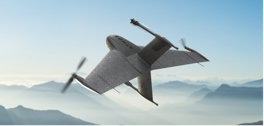
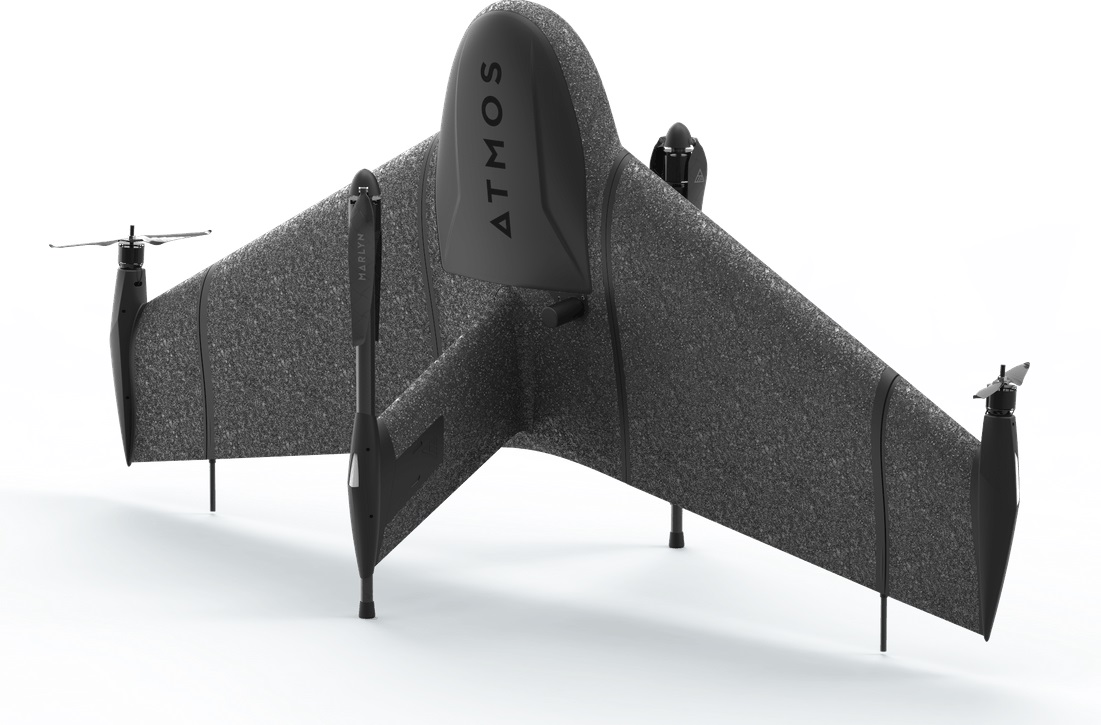
    Atmos has integrated the new Sony a6100 Oblique camera into its vertical take-off and landing (VTOL) fixed-wing UAV, the Marlyn Cobalt. The device can be used by professionals in the geospatial mapping and surveying sectors.

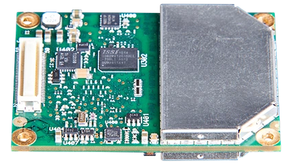
    The Sony a6100 Oblique camera is an innovative addition to the Marlyn Cobalt because it combines Sony’s 24MP a6100 with a Meike 12mm lens to provide users with a solution for lower-resolution surveying that produces 3D models for urban surveys.

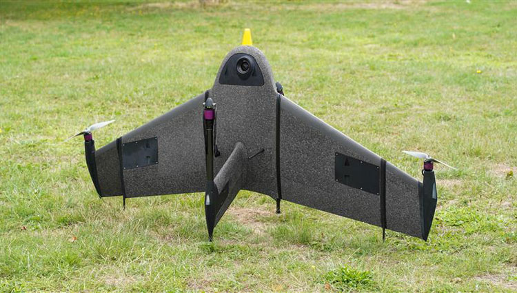
    With the integration, the Marlyn Cobalt boasts a 350-hectare coverage at 400 feet, reducing operational time and costs. The resulting ground sampling distance (GSD) of 4cm at that altitude ensures high-resolution data acquisition, delivering detailed images for precise analysis.

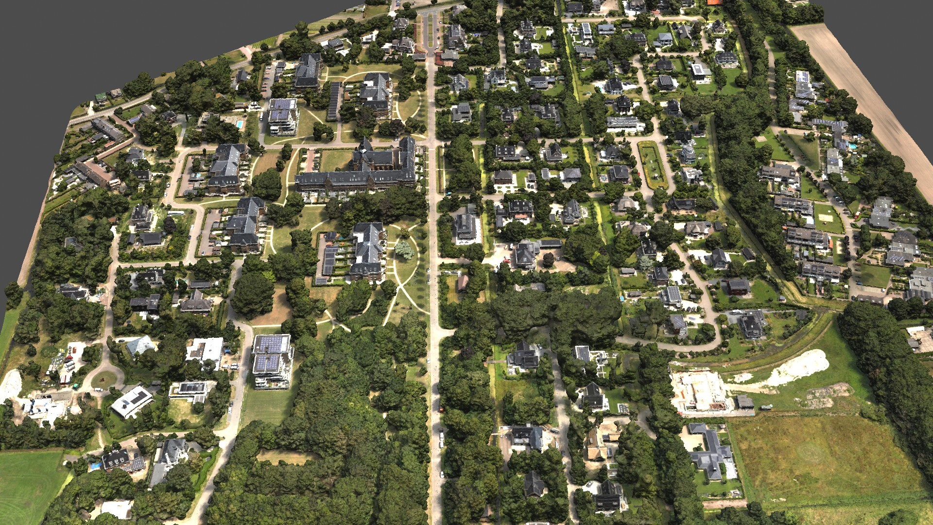
    The map below (Figure 1) was surveyed by one of Atmos’ customers. The UAV enabled them to identify and inspect the built and natural environment through different processing ways for urban planning in the town of Sancta Maria in the Netherlands.

    Figure 1: 3D reconstruction of the Sancta Maria urban area. (Image: Atmos)
    Figure 1: 3D reconstruction of the Sancta Maria urban area. (Image: Atmos)

    To learn more about the integration, visit the Atmos website 

  • Atmos appoints Topcon as official distributor in US

    Atmos appoints Topcon as official distributor in US


    Image: Atmos
    Image: Atmos

    Atmos — a Dutch UAV manufacturer that develops vertical take-off and landing (VTOL) fixed-wing UAVs for mapping and surveying applications — expanded its global reseller network by signing an agreement with Topcon Solutions. Topcon will be responsible for the distribution of Marlyn Cobalt UAVs in the United States and will provide assistance and maintenance services to local UAV operators.

    The Marlyn Cobalt is a VTOL fixed-wing mapping UAV developed by Atmos and enables users to collect accurate geospatial information and turn it into actionable insights.

    Atmos has integrated the Sony a7R mark III and IV cameras into the Marlyn Cobalt to increase the coverage and accuracy achieved in a single flight for surveyors. When combined with Zeiss’ 35 mm and 21 mm lenses, UAV surveyors can achieve ground sample distance levels of less than 1 cm. The integration of the two cameras enables Marlyn Cobalt users to map an area of 210 ha with centimeter-level accuracy in a single flight.

  • Atmos enhances UAV with Sony cameras

    Atmos enhances UAV with Sony cameras

    Image: Atmos
    Image: Atmos


    Atmos has integrated the Sony a7R mark III and IV camera into its vertical take-off and landing (VTOL) fixed-wing UAV, the Marlyn CobaltThis will increase coverage and accuracy achieved in a single flight for surveyors.

    Both cameras have an ISO of 32,000, which is expandable to 102,400, and camera sensors with high megapixel count — 42,4 MP for the a7R III and 61 MP for the a7R IV. When combined with Zeiss’ 35 mm and 21 mm lenses, it enables UAV surveyors to achieve ground sample distance levels below one 1 cm.

    The integration of the two cameras enables Marlyn Cobalt users to map an area of 210 hectares with centimeter-level accuracy in a single flight.

  • Atmos appoints Volatus Aerospace as official distributor in Canada

    Atmos appoints Volatus Aerospace as official distributor in Canada

    Photo: Atmos
    Photo: Atmos

    Atmos, a Dutch UAV manufacturer that develops high-end VTOL fixed-wing UAVs for mapping and surveying applications, expanded its global reseller network by signing a reseller agreement with Volatus Aerospace, a leader in commercial drones and UAV technology, in Canada.

    Volatus will be responsible for the distribution of Marlyn Cobalt UAVs in Canada and will provide assistance and maintenance services to local UAV operators. The company brings extensive experience in aviation operations, safety, compliance and innovation to the evolving uncrewed aircraft market.

    Marlyn Cobalt is the first fully autonomous hybrid (VTOL and fixed-wing) drone for mapping and surveying applications. With its patented design that combines the best of both worlds, Marlyn can take off vertically from anywhere and map fast and efficiently producing high-quality outputs for professional users. It is the only drone in its class that is built to perform even in harsh and windy conditions, while its easily swappable payloads provide operators with flexibility.

    “We have an incredible team pushing the envelope on the entire spectrum of UAV technology,” said Glen Lynch, CEO at Volatus Aerospace. “The Marlyn Cobalt survey drone is an exciting new addition to our product offerings.”

  • Topcon supplies GNSS boards for Atmos drones

    Topcon supplies GNSS boards for Atmos drones

    The Marlyn Cobalt drone. (Photo: Atmos)
    The Marlyn Cobalt drone. (Photo: Atmos)

    Topcon Positioning Group is supplying high-end GNSS boards for the Atmos Marlyn Cobalt drone.

    Topcon’s ultra-compact B111A GNSS receiver board can provide scalable positioning from sub-meter differential GPS to sub-centimeter real-time kinematic (RTK) positioning. The board’s flexible design — low power consumption, comprehensive communication interfaces and peripheral support — make it easy to integrate the B111A into any precise positioning application, Topcon said.

    Topcon';s B111A GNSS receiver board. (Photo: Topcon)
    Topcon’s B111A GNSS receiver board. (Photo: Topcon)

    Besides in surveying and mapping, survey drones are now used in a broad spectrum of applications ranging from construction and mining to agriculture and environmental monitoring.

    The Atmos Marlyn Cobalt is a vertical-takeoff-and-landing (VTOL) fixed-wing mapping drone developed by Atmos with the goal of allowing users to effortlessly collect accurate geospatial information and turn it into actionable insights. “Our mission is to provide professionals with the tool with which they can plan a better future with precision,” said Ruud Knoops, Atmos CEO.

    To provide precise positioning accuracy, a GNSS board needs to compensate for inaccuracies caused by satellite constellations, receiver hardware and atmospheric conditions.

    The use of Topnet Live — Topcon’s GNSS real-time correction service — provides high-accuracy positioning and survey-grade results to professionals through a 24/7 cross-border, consistent and reliable access. The combination removes the need for base stations, increasing efficiency leading to higher productivity and decreased costs.