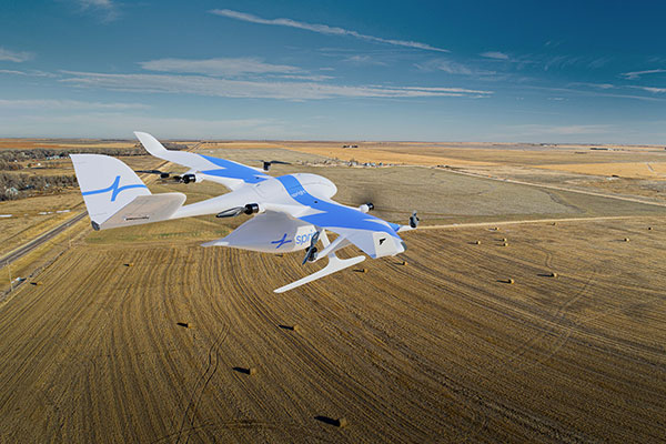
German drone-delivery company Wingcopter has signed a commercial agreement with Spright worth US$16 million to enable UAV medical deliveries.
Spright is a subsidiary of American air medical service provider Air Methods. Under the agreement, Spright is acquiring a fleet of Wingcopter’s flagship delivery drone, the Wingcopter 198, to meet the increasing demand for medical drone deliveries throughout the United States.
The contract makes Wingcopter the exclusive provider of fixed-wing electric vertical take-off and landing (eVTOL) delivery-drone technology to Spright. Spright, in turn, becomes exclusive provider of maintenance, repair and overhaul for the Wingcopter 198 to third parties in the United States.
Drone Division Launched
Spright was launched in July 2020 as the new drone division of Air Methods to improve healthcare access and minimize supply challenges for customers across the United States. To this end, Spright is creating a drone-based, U.S. healthcare-specific delivery network leveraging an existing infrastructure of more than 300 bases, serving hundreds of hospitals across 48 states in predominantly rural areas.
The agreement further strengthens the strategic partnership between the two companies, announced in August 2021. Spright is closely supporting Wingcopter in its Federal Aviation Administration (FAA) UAS type-certification process, leveraging Spright’s aviation experience operating FAA 121 and 135 air carriers, its existing Part 135 certificate (on-demand air service) and safety management system program.
Spright is collaborating with Hutchinson Regional Health System in Hutchinson, Kansas, for initial tests, and plans to expand the service beyond Kansas with additional strategic medical projects later this year.
The Wingcopter fleet will increase healthcare access across rural and underserved communities by enabling instant and on-demand delivery of vital medical supplies, medications, vaccines, blood and lab samples between medical facilities. It will also improve quality of care for patients with faster turn-around time of lab samples and more targeted treatments for patients.
Finally, the electrically powered Wingcopter cargo drones will reduce the medical industry’s carbon footprint, contributing to greener and more sustainable supply chains with faster and more predictable delivery times.
Wingcopter and Spright will showcase the Wingcopter 198 delivery drone and provide an opportunity to meet executives of both companies at the logistics tech conference Manifest in Las Vegas Jan. 25-27.
A Loyal Wingman drone rolls out, the U.S. Air Force (USAF) sponsors air taxi-cargo UAS development, and medical deliveries take place in Scotland and Florida — we have quite a wide selection for this month’s news.
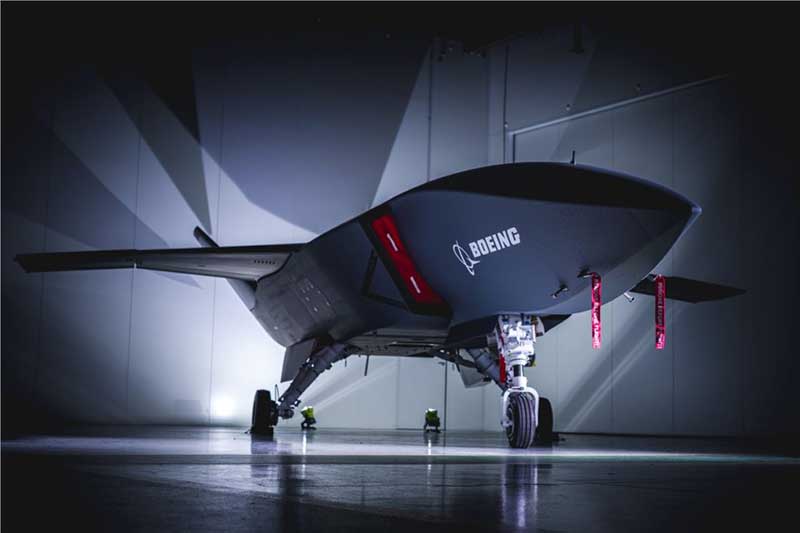
Fighter support drone
Boeing Loyal Wingman prototype (Photo: Boeing)
Boeing Australia has just rolled out the first “Loyal Wingman” for the RAAF (Royal Australian Air Force) — in essence what looks like a completed first article of three prototypes on order for Australia’s Loyal Wingman Advanced Development Program.
The concept is to develop an “inexpensive, expendable” UAV which will fight alongside today’s frontline fighter aircraft, controlled from the ground or from the air. A “force-multiplier” which doesn’t risk either pilot or the heap-expensive interceptor/ground attack aircraft themselves, a real bonus for smaller air-forces, and a less costly way of increasing numbers.
The first prototype will now go into a ground and flight test program to prove out systems and flight capabilities – first flight would likely be later this year.
A team of 35 Australian aerospace companies are supporting the Loyal Wingman project, including BAE Systems Australia which has been selected to supply the flight vehicle management system, flight control computers and navigation equipment.
Flying cars?
The U.S. Air Force wants a fleet of them by 2023!
So in a novel way to stir interest in the concept of flying cars, or perhaps cargo carrying drones, the Air Force launched a program known as “Agility Prime.” The program may have begun conventionally with seed contract(s) to drone manufacturers, but their latest “webcast” approach provided an extensive overview of what this could mean to the U.S. industry.
From April 27 through May 1, a panel including Air Force leaders, two U.S. Senators, NASA and Federal Aviation Administration management, and key Air Force and Defense Department players participated in an open presentation to industry, investment and State Government participants — all with the aim of accelerating civilian development of “advanced air mobility vehicles.”
Recognizing that a principle problem is overcoming regulatory hurdles, USAF intends to provide a route to commercial revenue service such as logistics transport and disaster recovery by perhaps providing access to its key testing capabilities and facilities. With broad participation in the program by industry, government and investors (i.e. USAF don’t intend to pay for it all) the program would satisfy an operational safety and security baseline and provide a platform for the “Race to Certification” of commercial drone product(s) the USAF might also want to buy.
One of the possible solutions for a cargo drone already funded includes the Sabrewing Cargo Drone – known currently as Rhaegal-A.
Four electric powered ducted fans rotate for Vertical Take-Off and Landing (VTOL) and are powered by a Safran (French) Ardiden 3 helicopter turbine engine – giving this large UAV a design speed of 245 mph, a ceiling of 20,000 feet and range of 1000 miles.
Sabrewing has received $3.25m under a two year USAF sponsored Small Business Incentive Research (SBIR) project in the hope that the design could be eventually adapted to military logistics applications. The vehicle is intended to be able to fly autonomously, has detect and avoid capability, and can even operate when GPS is continuously jammed — something the military would probably appreciate. Potential casualty evacuation is also of great interest.
Medical supplies delivery
Meanwhile in the U.K., in cooperation with the U.K. Civil Aviation Authority (CAA), Skyports drone company is playing in the CAA’s “Sandbox.” This is another term for an umbrella/sequence of trials under CAA safety and security constraints where innovative approaches are given a chance to demonstrate that new aviation related things are possible, that they actually work and that they meet the CAA criteria. Skyports wants to test out Beyond Visual Line of Sight (BVLOS) operations for its upcoming trial of medical deliveries between Oban and Mull off the West Coast of Scotland.
As front-line health professionals fight to beat the COVID-19 pandemic, deliveries of essential medical supplies between medical facilities can be speeded-up significantly using drones. Skyports will begin the week-long trial between Mull and Oban medical centers in the last week of May.
The planned BVLOS flights will be over a 17-mile route in unrestricted airspace and avoid the Oban airport, crossing the narrow sea channel and onto the North coast of the Isle of Mull. Skyports already has experience transporting medical and other high-value cargo in other parts of the world. The candidate drone is equipped with Iris Automation Casia detect-and-avoid computer vision system, and Thales Remote ID, and the Skyports drone team is also supported by Thales SOARIZON flight management and mission planning system.
Drones to deliver prescriptions
And finally, something quite helpful during the current coronavirus pandemic — CVS and UPS having linked up some time ago, are to begin delivering prescription medication to customers in Florida. The process has been previously checked out during November last year trials in Cary, N.C.
UPS will use the Swiss Matternet M2 delivery drone, picking up medication at specific CVS location(s) and flying it to a delivery point at “The Villages” in Central Florida, then the “last-mile” delivery is by road — presumably by an outfit which knows the layout of this huge facility where something like 130,000 retirees live. Useful during this phase of Florida’s self-quarantine for elders who may find it difficult to get out to the drug store. Hope they start running the same service out of my local CVS.
Wrap-up
So from the extreme military application of drone support for fighter attack missions, and USAF sponsored development of air-taxis and cargo drones, through to medical supply deliveries by drone in remote areas of Scotland and prescription deliveries in Florida — activity never seems to abate in this growing industry.
The u-blox ZED-F9P, a high-precision GNSS module that delivers centimeter-level accuracy within seconds, has been incorporated into the latest electric Tron F90+ fixed-wing unmanned aerial vehicles (UAVs).
Quantum-Systems, a German company that specializes in electric VTOL (vertical take-off and landing) aircraft for civilian use, manufactures the Tron F90+, which is employed in mission-critical logistical activities such transporting emergency blood reserves to remote locations. Other uses include mining and agriculture-related tasks.
Quantum-Systems and u-blox are both exhibiting at Intergeo in Stuttgart, Germany, Sept. 17-20. Quantum-Systems is at booth K1.074, and u-blox at booth L1.025.
The Tron F90+ has a 3.5-meter wingspan and can travel at speeds of up to 160 km/hour with a 100-km flight range. It is the latest addition to the Quantum-Systems eVTOL UAV platform designed for cargo, inspection, survey and mapping, and reconnaissance in adverse conditions. Other models include the Trinity F9, Scorpion and Vector UAVs, all of which feature u-blox F9 high-precision GNSS technology.
In developing the Tron F90+ UAV, the Quantum-Systems engineering team needed accurate enough position data to ensure that VTOL operations would always go smoothly, and the valuable payloads were protected from damage.
Through the multi-band real-time kinematic (RTK) and raw code and carrier-phase data available to the ZED-F9P, the necessary positioning correction is assured and the pilot can complete even difficult maneuvers. Absolute position accuracy can be brought down to 3-5 centimeters.
As Hurricane Florence rattles along the coastlines of the Carolinas and Georgia creating havoc, everything that flies is grounded. Right now the hurricane has slowed to a tropical storm, but flooding is extensive and people have died.
As soon as the high winds subside, expect almost all first response groups to put up UAVs to begin damage assessment. Digital images gathered by these drones will assist forward personnel to direct recovery and rescue operations. FEMA and other search and rescue teams, already in place along the track of the storm, have begun to rescue people by boat and are expected to fly drones over other inaccessible areas to find survivors.
And, of course, a significant part of the coverage we will see over the next week or so will come from drone-borne TV cameras and links to network uplink vans. We should also expect drones to be used for significant data gathering to map affected areas for damage to homes and infrastructure — including powerlines, radio and cellphone towers and distribution centers, waterways, roads and railways.
Let’s hope that the lessons learned and experience gathered during the major storms of last year will help everyone operating drones assist in minimizing the time to rescue people and to speed recovery from this latest hurricane. Later, expect the insurance companies to arrive with UAVs to assess damage and verify claims.
Police forces are using drones…
The law enforcement office in Dauphin County, Pennsylvania, has been using a drone for several months. With more than 13 investigations completed, the drone has helped locate one lost individual and has also supported crime-fighting.
Rather than calling out a manned helicopter for assistance, the police are able to get a drone in the air within 20 minutes at much less cost.
FAA regulations govern how Dauphin County law enforcement officials fly their drone, including a waiver granted to allow night-time operations.
…while Colombia is testing drones to destroy coca plants.
Recent growth in Colombian coca cultivation to 516,000 acres during 2012-2017 came as a consequence of the end of a government program to fumigate coca fields. Crop-duster planes spraying glyphosate had previously reduced Colombia’s coca fields from 470,000 to 193,000 acres during 2001-2012, according to U.S. figures.
Meanwhile, U.S overdose deaths from cocaine are continuing to increase, while rebels and drug traffickers have apparently shot down several crop-dusters.
Lawsuits against the use of the chemical glyphosate have also been successful. Over-spray is alleged to have killed other, legal crops, and opponents also cited a recent ruling in California that awarded $289 million in damages to a groundskeeper who said glyphosate-based weed killers had caused his non-Hodgkin lymphoma.
Because of concerns, Columbian police have been testing drones — flying a couple of feet above the plants to mitigate over-spraying of defoliants — to kill coca crops and reduce the supply of cocaine. Apparently, 10 remotely guided drones, each weighing 50 pounds fully loaded, destroyed hundreds of acres of coca in the first phase of tests. Though common in agriculture for the monitoring of crop growth, it’s thought that drones have never before been used to kill illegal crops. The fumigation appears to be about 90% effective to date.
Nevertheless, in Colombia’s drug zones, soldiers will be needed to partition swaths of coca-producing land and to defend operators from angry farmers and drug traffickers. There are also land mines which will need to be overcome from Colombia’s long rebel conflict and which pose a danger to drone operators.
Counter UAS (C-UAS) systems are on the rise.
The Drone Dome system uses Laser, RF and Radar. (Photo: Rafael)
As fast as drone technology is developing, counter UAS (C-UAS) systems are also being put in place to prevent unwanted drones from penetrating the air above sensitive facilities — by detecting and disabling them. There are purportedly more than 60 such C-UAS systems available in the U.S., with more in other countries including China and Russia.
Systems use various technologies for detection — such as radar, laser, optical/IR, RF “sniffer,” and acoustic. Drones can be disabled by RF and GNSS jammers, by spoofing of both the GNSS navigation or the control link, and can be brought down physically by high-power lasers, nets deployed by other drones, collisions by attack drones, by regular or specialized anti-drone gun systems and even by high-pressure water cannons for very close-in defense. Anti-drone systems include detection and take-down dome-based systems and man-portable drone guns.
SpotterRF C-UAV radar. (Photo: UAS Vision)
The UK government has acquired the Drone Dome C-UAS (counter-UAS), manufactured by Rafael, Israel. Detection is provided by an S-band radar (four radars provide all-round coverage), an electro-optical/infrared (EO/IR) surveillance suite, and a wideband RF sensor.
Drones can be disabled by a high-power laser, an RF jammer, or when very close-in by a high-pressure water gun. The UK system is expected to use jamming to bring down drones and doesn’t include the high power “hard-kill” laser option.
Depending on the size of the intruder drone, the radar detection range is around 3.5-10 kilometers, and the radar may also disable a UAV when integrated with the RF jammer. With an active electronically scanned array antenna, the radar is relatively small and light-weight for both fixed and mobile installations.
The DroneGun. (Photo: DroneShield)
Another C-UAV offering, from SpotterRF, claims to solve the problem of requiring multiple radar elements to achieve 360-degree “dome” coverage. The 3D-500 radar enables full “dome-drone” detection from 0 to 90 degrees vertical and 360 degrees horizontal using a single radar with a 500-meter detection radius, yet weighs only 12 pounds.
Latitude, longitude and altitude of intruder targets are measured within a 1-kilometer diameter hemisphere dome. Following radar detection of an unauthorized drone, the system may be augmented by a slew-to-cue optical/IR camera providing a visual display to an operator — a directional RF jammer on a pan/tilt turret can then be activated to take-down the intruder. The system operates automatically to both detect and disable the drone, or manual control is possible to enable initial operator confirmation of the target before take-down is activated.
DroneShield out of Australia markets a drone detection and mitigation system probably best known for its DroneGun. The DroneGun is a point and shoot device able to disrupt multiple RF frequency bands simultaneously (433 MHz, 915 MHz, 2.4 GHz and 5.8 GHz), taking out the communication link to a drone operator — and also GNSS signals when so equipped — up to 1 kilometer away.
The full DroneSentry detection system integrates a suite of sensors and countermeasures including radar, optical, RF listening, acoustic, thermal and an RF countermeasure transmitter with greater power and range than the portable DroneGun.
Another example is the Rex-1 drone gun. Operating in the 2.4 GHz and 5.8 GHz bands, the Rex-1 rifle-like drone-disabling device is a man-portable jammer developed by Russian Kalashnikov Group subsidiary ZALA Aero Group.
https://youtu.be/Px56KtpZ004
Mapping and survey are becoming a major application for drones.
One such example is 3D mapping of a copper mine in only three days using a fixed-wing UAS.
At an altitude of 1,400 meters, the Erdenet open-pit mine in Mongolia extends 5 x 2 kilometers and is more than 200 meters deep in places. Despite strong winds and even some snow in May this year, one UAS quickly captured geospatial data that enabled three-dimensional modeling of the large, complex site.
Site management is expected to use this initial model as a baseline against which future drone-maps will be compared, and to plan future mine operations.
However, extensive preparations over a two-week period were still required, including the installation of 21 ground control points, positioned using GPS RTK measurements. Re-verification of these points was also required from time to time before the survey, due to changes in the mine from ongoing mine operations, including dynamite blasting.
A MAVinci Sirius UAV was used to gather almost 7,000 aerial photographs which were processed through Agrisoft Photoscan Pro software to produce a detailed digital surface model. All the data collected will be used to create various internal views of the mine for continued mining operations. The mine produces about 26 million tons of ore each year, leading to approximately 530,000 tons of copper and 4,500 tons of molybdenum derivatives.
UAVs make medical deliveries.
Some U.S. medical facilities will soon be participating in a Department of Transportation test program to transport medical samples and supplies by UAV — the object being to obtain test results and medical supplies much quicker than at present. Matternet, Zipline and Flytrex — UAV companies already involved in deliveries by drone — will use several different UAVs in the program, which also aims to set up a number of medical distribution centers.
Matternet has been delivering medical supplies by drone in Switzerland, and Flytrex is focusing on food and package deliveries.
Delivery drone in Kasungu, Malawi. (Photo: AFP)
Meanwhile, Zipline and UNICEF have established an “air corridor” in the city of Kasungu in Malawi to test the transport of medical supplies by drone. Rwanda had previously used UAVs to deliver medication in Africa. Other underdeveloped countries without good ground infrastructure could well benefit by using life-saving drone deliveries for urgently needed medication.
Supporting police investigations, mapping of mines, and coca crop destruction all seem to be good examples of newer uses for unmanned air vehicles. And when policing of drone intrusion is required, looks like there are many new options to detect, disable and even take down unwanted drones. I’d say we seem to be making good progress towards better acceptance and that the industry is starting to grow up.
And let’s all hope that the efforts of all first responders in the Carolinas and Georgia continue through the many weeks of recovery from flooding and damage that are still to come, and that people can soon get back into their homes.