Tag: Mediterranean

  • US Coast Guard protests GPS disruption to UN body: ‘urgent issue’

    US Coast Guard protests GPS disruption to UN body: ‘urgent issue’

    The International Maritime Organization headquarters in London. (Photo: Anastasia Yakovleva/iStock Editorial / Getty Images Plus/Getty Images)
    The International Maritime Organization headquarters in London. (Photo: Anastasia Yakovleva/iStock Editorial / Getty Images Plus/Getty Images)

    Responding to a plea from 14 maritime organizations in the fall of 2019, the U.S. Coast Guard has protested disruption of GPS and GNSS signals to the International Maritime Organization (IMO).

    IMO is the United Nations body that coordinates and sets standards for international maritime operations and safety.

    In a paper dated March 10, the service said that GNSS signals are “essential to safe and efficient navigation and an integral component of all maritime operations.” Interfering with them “jeopardizes the safety of life at sea.”

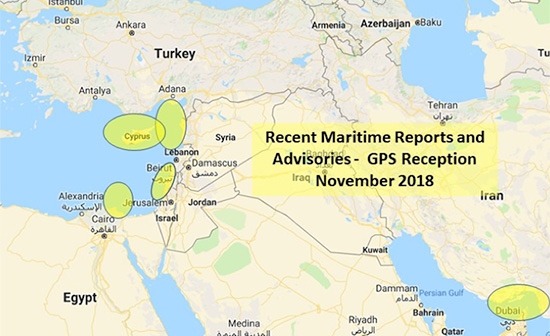
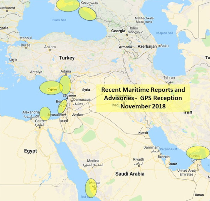
    Deliberate disruptions in the eastern Mediterranean and the Black Sea, the paper says, affect vessels operating in international waters and engaged in innocent passage through territorial seas.

    While nations typically have a right to do as they wish in their sovereign territory, they are also obliged to not have that intrude into other nations’ territory or international waters. This is also true for vessels passing through their waters but not calling at their ports, known as “innocent passage.”

    The International Law of the Sea Treaty stipulates that, in the absence of some clear wrongdoing such as piracy, drug smuggling or discharging oil, vessels be allowed to pass through territorial seas unmolested by the coastal state.

    The Coast Guard paper also points out that nations have other treaty obligations that prohibit this kind of activity. International Telecommunication Union Radio Regulations prohibits “All transmissions with false or misleading identification…”

    Citing a March 2019 report in GPS World, the paper also documents that GNSS disruption is a global problem not confined to just one or two areas. A study by the German Aerospace Center (DLR) found interference during every phase of a vessel’s voyage between Europe and the Far East.

    The Coast Guard paper was submitted for consideration at IMO’s Maritime Safety Committee that had been scheduled to meet on May 13, but has been postponed due to the COVID-19 emergency.

    This planned consideration at IMO follows a resolution by the UN’s International Civil Aviation Organization (ICAO) in May 2019. In a paper entitled “An Urgent Need to Address Harmful Interferences to GNSS,” the International Federation of Air Traffic Controllers’ Association (IFATCA), the International Federation of Air Line Pilots’ Associations (IFALPA), and the International Air Transport Association (IATA) had introduced the issue.

    This resulted in a resolution describing the eliminating interference as an urgent need.

    About the same time the U.S .Coast Guard paper was due to be considered, IMO was to engage in the early stages of considering rules for autonomous vessels. Its Facilitation Committee was scheduled hold a “Regulatory scoping exercise for the use of Maritime Autonomous Surface Ships (MASS)” at a meeting the end of April. This meeting has also been postponed.

    While not specifically mentioned, navigation issues will undoubtedly be part of the considerations when discussion of rules for autonomous shipping eventually takes place.

    Public input to these international meetings is always sought in advance. For example, the U.S. State Department had announced a meeting for April 6 to receive public input on U.S. positions for the various issues to be discussed at the Facilitation Committee.

    While we understand that this meeting will also be also be postponed, comments can be submitted to the points of contact listed in the Federal Register announcement as well as be raised during the eventual meeting.

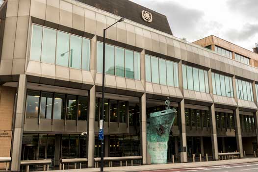
    Image: IMO Headquarters Wikimedia Commons

  • GPS disrupted for maritime in Mediterranean, Red Sea

    GPS disrupted for maritime in Mediterranean, Red Sea

    The U.S. Maritime Administration issued an expanded advisory for GPS disruptions in the Middle East. The new advisory renews and repeats warnings for the eastern Mediterranean and adds the Port of Jeddah in Saudi Arabia.

    Reports have also been filed  with the U..S Coast Guard Navigation Center  about disruptions in Israel’s Port of Haifa and the Straits of Hormuz.

    Analysis by the Resilient Navigation and Timing Foundation and the non-profit firm C4ADS has also shown on-going disruptions in Russian waters of the Black Sea. Also, GPS jamming by Russia is suspected during a recent NATO exercise.

    The armed conflict in Syria has been blamed for much of the disruptions off of its shores.

    GPS jamming in support of illegal fishing is suspected by some as the cause of problems off of Port Said, and disputes over mineral rights has been suggested for the disruptions seen near Cyprus.

    Disruptions in the Black Sea are suspected to be security measures associated with the travel of Russian government officials.

    Map: U.S. Maritime Administration Advisory 2018-014-GPS
    Map: U.S. Maritime Administration Advisory 2018-014-GPS

    Text of Maritime Administration Advisory

    2018-014-GPS Interference-Eastern Mediterranean and Red Sea

    This revised advisory cancels U.S. Maritime Advisory 2018-007.

    Reference: U.S. Maritime Alerts 2018-004A, 2018-004B, 2018-008A.

    Issue: Multiple instances of significant GPS interference continue to be reported by vessels and aircraft operating in the Eastern Mediterranean Sea. These reports have been concentrated near Port Said, Egypt, the Suez Canal, and in the vicinity of the Republic of Cyprus. Additional instances of similar interference were reported in October 2018 near Jeddah Port, Saudi Arabia. This interference is resulting in lost or otherwise altered GPS signals affecting bridge navigation, GPS-based timing and communications equipment.

    Guidance: Exercise caution when transiting these areas. The U.S. Coast Guard Navigation Center (NAVCEN) and NATO Shipping Center websites contain information regarding effective navigation practices for vessels experiencing GPS interference. The information reaffirms safe navigation practices when experiencing possible GPS disruption, provides useful details on reporting possible GPS disruption, and is intended to generate further discussions within the maritime community about other disruption mitigation practices and procedures. This guidance also recommends taking note of critical information such as the location (latitude/longitude), date/time, and duration of the outage/disruption, and providing photographs or screen shots of equipment failures during a disruption to facilitate analysis. The NAVCEN information is available at https://go.usa.gov/xQBaU.

    Contact Information: GPS disruptions or anomalies should be immediately reported to the NAVCEN at https://go.usa.gov/xQBaw or via phone at 703-313-5900, 24 hours a day. The NATO Shipping Center has requested that instances of GPS interference also be reported to them using the format on their Cyber Interference link.

    Cancellation: This message will automatically expire on May 2, 2019.

    Link To MARAD Advisory


    Dana Goward is president of the nonprofit Resilient Navigation and Timing Foundation.