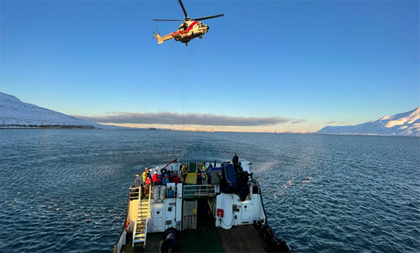
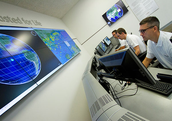
The AMRO 2021 exercise tested the rescue of 200 cruise-ship passengers using Galileo SAR. (Photo: EUSPA)
News from the European Union Agency for the Space Programme (EUSPA)
In freezing arctic waters 60 nautical miles off of Svalbard, a search-and-rescue enactment proved the capabilities of Galileo as a life-saving system.
The Arctic Mass Rescue Operation (AMRO 2021) took place on Oct. 8, organized by the Norwegian authorities. The scenario surrounded a cruise ship that caught on fire with around 200 passengers onboard, located northwest of Spitsbergen far from roads, cabins, rescue crews and other infrastructure.
The vessel’s crew activated a Galileo-enabled EPIRB compatible with Galileo’s Return Link Service. Once activated, it took only 2:20 minutes for the Galileo System to track down the ship with an accuracy below one kilometer and deliver an SOS acknowledgement to the active EPIRB.
Once the Mission Control Centers received the distress signal and established the location, two Super Puma helicopters from the Governor of Svalbard, a Sea King from the 330 squadron of the Royal Norwegian Air Force, and a Norwegian coast guard support vessel were scrambled to support the massive evacuation of the passengers.
‘’The AMRO 2021 exercise was an excellent opportunity for the European Union Agency for the Space Programme to showcase the power of Galileo SAR and the robust performance of Galileo at high latitudes in comparison to other GNSS constellations,’’ said Guerric Pont, Head of Galileo Department at EUSPA.
The Galileo RLS allows people in distress to receive an automatic acknowledgment that their signal has been picked up by the first responders. Galileo’s contribution to the Medium Earth Orbit Satellites Search and Rescue System (MEOSAR) — managed by the international COSPAS-SARSAT program — translates into 2,000 lives saved per year.
In support of Galileo’s SAR operations, the Copernicus Marine Service provides authorities and rescue centers input such as wave height, sea current direction as well as and water temperature among others.
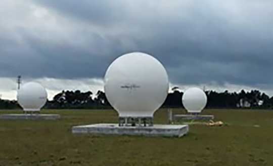
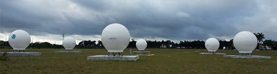
Orolia has successfully installed the first operational Cospas-Sarsat second-generation technology on search-and-rescue ground stations for the National Oceanographic and Atmospheric Administration (NOAA) in Florida and Hawaii.
The ground stations have been upgraded with second-generation beacon (SGB) signal-processing capabilities to more accurately and quickly locate the source of distress signals.
The NOAA Florida and Hawaii ground stations are the only operationally ready Medium Earth Orbit Search and Rescue (MEOSAR) ground stations in the world to receive the SGB signal specification capability.
The Cospas-Sarsat global search-and-rescue system developed specifications for the second-generation 406-MHz search-and-rescue beacon, which uses a modern, spread-spectrum signal to achieve more accurate and robust performance.
“The work performed by Orolia was exceptional, as the process of upgrading an operational system to a higher set of requirements, years after its initial design, involves minimizing downtime while validating the new requirements and revalidating the previous requirements,” said Mickey Fitzmaurice, NOAA SARSAT Systems Engineer. “The successful result makes it obvious that the engineering and operations team at Orolia put a great deal of time and effort into planning the upgrade, as the execution was seamless.”
“This series of world firsts demonstrates Orolia’s broad technical leadership in the global search and rescue ecosystem,” said Orolia Director of SARSAT Operations, Steve Ludwig. “We continually innovate to enhance the usefulness of these technologies, from generating encrypted beacon alert signals to including alert authentication through the use of Galileo Return Link Service.”
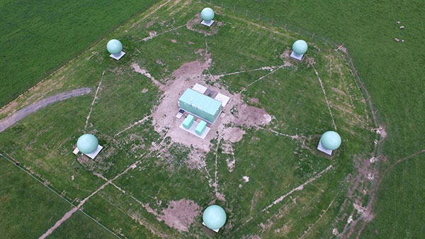
Cospas-Sarsat ground stations are called Local User Terminals (LUTs). These satellite receiving units are the ground stations that receive emergency beacon distress alerts. (Photo: NOAA)
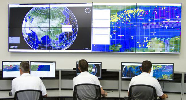
Orolia’s LEOSAR-GEOSAR-MEOSAR (LGM) Mission Control Center (MCC) solutions are now commissioned as Nodal MCCs in Spain and Australia, enabling global distribution of critical search-and-rescue information through the Cospas-Sarsat system.
With the successful commissioning of their Nodal MCCs, Spain and Australia will now be able to share critical information with the U.S. and France, providing worldwide coverage for global search and rescue.
In addition, since they will be authorized to commission other MCCs in their regions, they will also significantly advance the Cospas-Sarsat MEOSAR program.
Orolia’s McMurdo PRISMA MCC features satellite search-and-rescue technology with full LGM capability. It is the commercial solution of choice for search-and-rescue authorities in Norway, the UK and many other countries.
“We’re proud to support the world’s most critical search and rescue operations,” said Steve Ludwig, Orolia’s director of SARSAT Operations. “With Orolia onboard, you can rely on proven solutions in critical environments where failure is not an option. Our PRISMA Mission Control Center systems are the only successfully deployed, Cospas-Sarsat commissioned commercial solutions available, meeting the highest standard for search-and-rescue support.”
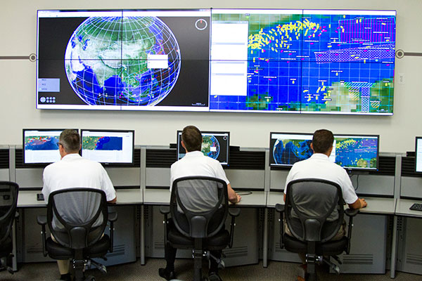
The Orolia PRISMA Mission Control Center. (Photo: Orolia)
Orolia has been developing global search-and-rescue programs for nearly 30 years, reaching a major milestone with the Medium-altitude Earth Orbit Search and Rescue (MEOSAR) system in 2011, and completing all global MEOSAR system installations since.
To date, 75 percent of the Earth’s surface is monitored by Orolia’s MEOSAR systems.
Through its McMurdo brand, Orolia has equipped these systems with the latest search-and-rescue technology to increase response times and save more lives worldwide.
Emergency preparedness company McMurdo has launched a new family of Emergency Position Indicating Radio Beacons (EPIRBs) that will accelerate the search-and-rescue process by combining multiple frequencies — including GNSS — into a single EPIRB product.
The McMurdo SmartFind and Kannad SafePro EPIRBs are distress beacons that can support each of the four frequencies used in the search-and-rescue process: GNSS for location positioning, 406 MHz and 121.5 MHz for beacon transmission, and Automatic Identification System (AIS) for localized connectivity.
The multiple-frequency capability will ensure faster detection, superior positioning accuracy, greater signal reliability and, ultimately, accelerated rescue of people or vessels in distress, the company said.
Expanded satellite connectivity. McMurdo SmartFind and Kannad SafePro EPIRBs have a multiple GNSS satellite constellation receiver supporting Galileo (once the constellation is fully operational), GPS and GLONASS — from a single beacon. Advanced GNSS data processing results in faster detection of positioning coordinates and enhances the accuracy of the emergency location.
Most of today’s EPIRBs use 406 MHz and 121.5 MHz frequencies via satellite communication to provide location and positioning data to global search and rescue personnel who may be several hundred miles away.
The additional AIS channels on the new McMurdo SmartFind G8 AIS and Kannad SafePro AIS EPIRBs will send position signal information to standard AIS electronic equipment on nearby vessels for complementary, local tracking and rescue capabilities. This global and local rescue capability will result in quicker signal detection and faster response times.
The McMurdo SmartFind and Kannad SafePro EPIRBs are part of McMurdo’s comprehensive search and rescue ecosystem. As the world’s provider of an end-to-end search and rescue ecosystem — including distress beacons, satellite ground stations, mission control and rescue coordination systems, and rescue response products — McMurdo builds, integrates and tests products as part of a live search and rescue system. This ensures greater cohesion between distress signal transmission and reception so that beacon owners can feel confident that their signals will get to search and rescue authorities quickly.
MEOSAR compatibility. The McMurdo SmartFind and Kannad SafePro EPIRBs are designed to be fully compatible with MEOSAR, the next generation of the Cospas-Sarsat international search-and-rescue satellite system that has helped to save over 40,000 lives since 1982. MEOSAR will increase the speed and accuracy of beacon signal detection and location with new MEOSAR ground network infrastructure and additional MEOSAR satellites.
When fully deployed, a MEOSAR-compatible beacon can be located with an accuracy of location within 100 meters (328 feet), 95 percent of the time — and within five minutes of distress signal activation, all without reliance on GNSS.
McMurdo manufactures approximately 50 percent of the world’s MEOSAR infrastructure and is also leading the design of additional MEOSAR-capable beacons under the European Union’s Horizon 2020 Research and Innovation Program’s HELIOS project.
“McMurdo’s new EPIRB announcement is a major step towards achieving a unified search-and-rescue vision,” said Bruce Reid, CEO of the International Maritime Rescue Federation. “The convergence of products and systems whether AIS and 406 MHz or maritime domain awareness and search and rescue, respectively, will require a comprehensive understanding of the entire search and rescue ecosystem. I look forward to seeing more McMurdo solutions and innovations that will shape the search and rescue industry for years to come.”
The McMurdo SmartFind and Kannad SafePro distress beacons support beacon transmission, GNSS for location positioning, and AIS for localized connectivity.
Emergency readiness and response company McMurdo has completed the installation of a six-antenna next-generation Medium-Earth Orbit Search and Rescue (MEOSAR) satellite ground station system in New Zealand.
The project, which is part of a joint initiative with Maritime New Zealand and the Australian Maritime Safety Authority, is expected to significantly boost search-and-rescue capability in the New Zealand and Australia search regions and marks the first implementation of MEOSAR in Asia Pacific.
MEOSAR is the next-generation version of Cospas-Sarsat, the international search-and-rescue satellite system that has helped to save 37,000 lives since 1982. Cospas-Sarsat is in the process of upgrading its satellite system by placing search-and-rescue transponders on new GPS, GLONASS and Galileo satellites. Once qualified as operational, this system augmentation will dramatically improve both the speed and location-accuracy for detecting beacons.
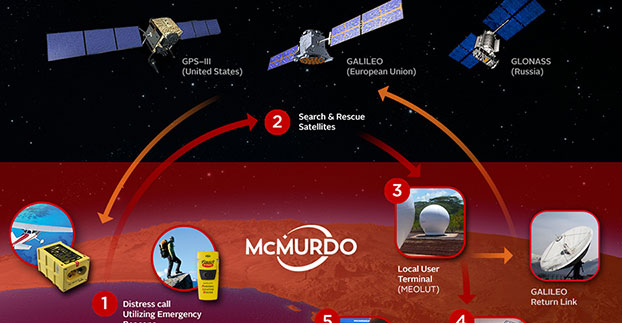
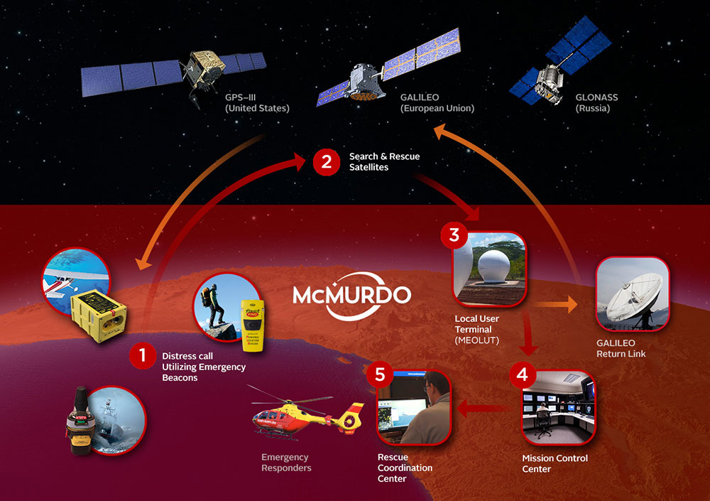
In a typical satellite-based search-and-rescue scenario, ships, aircraft or individuals transmit distress signals from an emergency location beacon via satellite to a fixed ground receiving station or local user terminal. The ground station receives and calculates the location of the distress signal and creates and sends an alert to the appropriate rescue authorities. Today, the beacon-to-alert process depends on a limited number of low Earth orbit (LEO) satellites and may take several hours before a position is confirmed. With MEOSAR, beacon signals will be received more quickly and beacon locations identified with greater accuracy thereby reducing this time to minutes.
“Beacons can take the ‘search’ out of search and rescue, and the MEOSAR system will dramatically increase the global search-and-rescue capability,” said Maritime New Zealand Director Keith Manch. “Emergency distress beacons are key equipment for anyone operating at sea, on land and in the air – whether commercially or recreationally — but they can’t operate without sites like this.”
“This key installation firmly establishes McMurdo as the premier MEOSAR infrastructure provider globally,” said Remi Julien, McMurdo president. “We are committed to partnering with both Maritime New Zealand and the Australia Maritime Safety Authority to ensure that they have the technology, training and long-term support in place to significantly reduce search-and-rescue times and, ultimately, save more lives today and in the future.”
The New Zealand MEOSAR system, and another being installed in Western Australia, will cover one of the largest search-and-rescue areas in the world — from north of Australia/New Zealand to the Equator and south to the South Pole, east to half way across the Pacific, and west half way across the Indian Ocean. The systems will undergo rigorous testing before being officially brought online in late 2017 by Cospas-Sarsat.
There are 58,000 emergency distress beacons registered in New Zealand which, without any changes or updates, will be immediately usable by the new systems. It is estimated, however, that an additional 25,000 beacons are unregistered. Due to the high responsiveness of the MEOSAR system, search-and-rescue authorities strongly recommend beacon registration. This will help the unnecessary deployment of search-and-rescue resources due to inadvertent beacon activations. The Rescue Co-ordination Centre New Zealand, part of Maritime New Zealand, responds to 550 beacon alerts a year.
In a typical Cospas-Sarsat search and rescue process, a distress beacon signal is sent via satellite to a local user terminal. A mission control center validates the emergency and sends critical information to rescue coordination centers. MEOSAR, the next-generation version of Cospas-Sarsat, will provide several unique features including a return link service function to acknowledge receipt of the distress signal.
McMurdo has introduced PRISMA MCCNet, a new software solution with several new features to improve the Cospas-Sarsat satellite-aided search and rescue process, and for use in the future MEOSAR system. The software, which is part of McMurdo’s suite of PRISMA (Preparation, Response, Identification, Surveillance, Management, Acceleration) software solutions, provides mission control center (MCC) operators with critical tools to better identify, locate and manage distress situations.
In a typical Cospas-Sarsat search and rescue scenario, a distress signal from an emergency beacon is sent via satellite to a fixed ground receiving station or local user terminal. The nearby MCC confirms the emergency, analyzes location data and provides this information to the various rescue coordination centers for the actual rescue operation. PRISMA MCC’s improved functionality includes built-in system redundancy, unified communications and automated reporting to improve the MCC operation and streamline the search and rescue process.
The international Cospas-Sarsat satellite system is best known for detecting and locating emergency beacons activated by aircraft, ships and backcountry hikers in distress and has been credited with saving 37,000 lives since 1982. The system includes satellites in low-altitude Earth orbit (LEO) and geostationary Earth orbit (GEO). The future Cospas-Sarsat system will include medium-altitude Earth orbit (MEO), which will form the MEOSAR system. Satellites in the MEOSAR system include GPS, Galileo and GLONASS satellites, which are incorporating search and rescue payloads.
“PRISMA MCCNet provides Mission Control Center operators with a powerful, comprehensive and reliable software tool that provides the most accurate data and most up-to-date information to expedite the search and rescue process,” said Jacob Blankenship, search and rescue business manager for McMurdo. “With several advanced features and innovative functions based on our years of experience working with the leading search and rescue authorities around the world, the end result will be faster decision making and, ultimately, more lives saved.”
McMurdo’s PRISMA MCCNet software will help improve a Cospas-Sarsat satellite-aided search and rescue system that has helped to save 37,000 lives since 1982.
PRISMA MCCNet provides significant improvements in several key areas to enhance mission control center operations including:
High Availability with Support for Automatic Failover — PRISMA MCCNet includes new automatic failover and built-in redundancy features to maximize availability and uptime of the search and rescue system.
Unified Inbox and Communications — Easy to use and organize, PRISMA MCCNet’s Unified Inbox displays all actionable events that require operator interactions including beacon alerts, narrative messages, or system level alarms on a single screen. This information, which traditionally required the use of multiple screens, can be sent easily and reliably to rescue authorities via multiple communications protocols and redundant link transmission.
Advanced Monitoring and Reporting — PRISMA MCCNet’s built-in automatic diagnostic and analytical tools continuously detect, trace, and report malfunctioning components and processes. Quality Management System (QMS) analysis tools provide real-time tracking of system performance.
Client-Server Architecture — Unlike traditional MCC systems, PRISMA MCCNet is based on a secure and scalable client-server architecture allowing multiple MCC workstations to access consistent data and information from a centralized or distributed server configuration.
Commissionable LEOSAR/GEOSAR/MEOSAR MCC — PRISMA MCCNet was developed in close association with Cospas-Sarsat, National Oceanic and Atmospheric Administration (NOAA), NASA and other search and rescue authorities. This ensures a seamless commission/certification process for LEOSAR/GEOSAR/MEOSAR MCCs.
McMurdo’s PRISMA MCCNet software streamlines mission control center operations with features including built-in system redundancy, a unified inbox and advanced monitoring tools.
“The launch of PRISMA MCCNet is yet another milestone in McMurdo’s journey to become the global leader in emergency readiness and response,” said Jean-Yves Courtois, McMurdo CEO. “It provides a solid foundation upon which we can build a world-class, integrated ecosystem of products, technologies and services for preventing emergencies, protecting assets and saving lives.”
McMurdo provides the world’s only complete, end-to-end emergency readiness and response solution including distress beacons, search and rescue satellite infrastructure, mission control and rescue coordination centers and maritime domain awareness solutions including coastal surveillance and vessel monitoring systems. The world’s leading search and rescue authorities in the U.S. (NOAA and NASA), Australia (Australia Maritime Safety Authority), New Zealand (Maritime New Zealand), Cyprus, South Africa, Argentina and other countries use McMurdo search and rescue systems.
The Canadian government will begin providing search-and-rescue repeaters for the U.S. Air Force’s GPS III satellites, reports Space News. The repeaters provided by Canada’s Medium Earth Orbit Search and Rescue (MEOSAR) satellite project will significantly reduce the time it takes to locate a distress signal.
Canada’s Department of National Defence will begin negotiations with the U.S. Air Force to install 24 repeaters on GPS III satellites, starting with the 11th GPS III satellite. Canada’s MEOSAR satellite project includes construction of three ground stations, to be built by 2020.
The MEOSAR satellite payload is being developed for GPS III satellites.
The Canadian government first announced the MEOSAR project in 2013, awarding Com Dev International of Cambridge, Ontario, an initial contract worth 4.7 million Canadian dollars for research and design work on the repeaters. Despite completion of that phase, Canada’s Department of National Defence put the project on hold, possibly for budgetary reasons.
A contract award for the MEOSAR repeaters is now expected to be announced next year.
A MEOSAR repeater will be able to detect signals from emergency beacons and retransmit the signals to receiver stations on the ground. The emergency messages can then be sent to appropriate authorities so that people in danger can be quickly located and rescued.
MEOSAR will provide a more capable system than COSPAS-SARSAT, an international satellite-based search and rescue distress alert detection system established by Canada, France, the former Soviet Union and the United States in 1979. It is credited with saving more than 33,000 lives since its inception. MEOSAR will reduce the time it takes to detect and locate a distress signal from an hour to around five minutes.
Com Dev began the development of its MEOSAR technology in 2008 under a cost-shared research and development project with the Canadian Space Agency. Canada’s National Search and Rescue Secretariat also later provided additional R&D support.
The search and rescue transponders were originally destined for Galileo, according to Space News, but stalled because Canada lacked a defense certificate to be able to supply the Galileo program.
McMurdo Group, an end-to-end search and rescue (SAR) and maritime domain awareness (MDA) company, has acquired Techno-Sciences, Inc. (TSi), a provider of SAR satellite ground stations, integrated emergency response center systems and coastal surveillance solutions. Terms of the acquisition were not disclosed. TSi’s Beltsville, Maryland, location becomes the U.S. headquarters for McMurdo Group, a division of Orolia, global specialist in critical GNSS solutions.
TSi has been instrumental in the development of the COSPAS-SARSAT international satellite-based SAR program, which has helped to save more than 35,000 lives worldwide since 1982. TSi is also actively involved in the next-generation COSPAS-SARSAT system, MEOSAR (Medium Earth Orbit Search and Rescue), which will greatly improve the existing SAR process with near-instantaneous detection, identification and location of emergency distress beacons.
MEOSAR, currently in its demonstration and evaluation phase, is expected to have initial operational capability in 2016 and full operational capability by 2018. MEOSAR will use SAR-enhanced Galileo (Europe), GPS (U.S.) and GLONASS (Russia) satellite constellations for greater global coverage and includes innovative end-user beacon functionality such as a return-link service on Galileo satellites to acknowledge distress signal receipt and provide ongoing rescue effort status.
“The acquisition of TSi firmly establishes McMurdo Group as the global leader in satellite-based search and rescue solutions. We are the only provider capable of supplying a single-vendor, end-to-end COSPAS-SARSAT emergency solution with a seamless ecosystem of products, technologies and processes that will streamline and expedite search and rescue efforts,” said Jean-Yves Courtois, CEO, McMurdo Group and its holding company Orolia Group. “TSi expands our global sales, support and customer footprint and adds to our already extensive expertise in SAR and MDA. We look forward to developing a U.S. SAR Center of Excellence to include manufacturing, distribution and support of McMurdo Group’s broad solution offering of distress beacons, AIS equipment, satellite communications units and emergency control centers equipped with search and rescue management software.”
TSi solutions are installed in more than 20 countries worldwide and include satellite ground stations or local user terminals (LUTs), rescue and mission control centers, and coastal surveillance/instruction detection systems. TSi installed the world’s first operationally ready six-channel MEOSAR LUT (MEOLUT) in 2011 for the U.S. National Oceanic and Atmospheric Administration (NOAA) and has recently completed a second NOAA installation (March 2014). With a team of 40 employees, TSi has a prominent list of government, military and commercial customers in Asia, Europe, Africa and the U.S. (including NOAA, NASA and the U.S. Navy).
The U.S. Air Force Space and Missile Systems Center (SMC) announced in late August that the long-planned upgrade of the GPS command and control system will occur during the second week of September, fulfilling a major program commitment for 2007.
Dubbed the Architecture Evolution Plan (AEP), the upgrade will replace the entire GPS master control station, including both software and hardware, some of which dates back to GPS’s inception in the 1970s. The upgrade will, among other things, begin preparing the master control station to work with the latest generation of Block IIF satellites when they go into orbit; further work with the next-generation OCX, however, will be necessary for managing M-code and the new L5.
“The delivery of SMC’s new GPS ground segment to the 50th Space Wing [will enable] transition of satellite operations from a 1970s-era GPS mainframe computer to a new server-based AEP ground segment,” said Lt. Gen. Michael Hamel, SMC Commander. “I am very proud of the team that has thoroughly tested the new system to ensure no change to the GPS signal during the changeover to the new system. The best analogy I could make is that this is like changing the engine on a car while traveling 50 miles an hour down the road.”
Col. David Madden, GPS Wing Commander, added “The replacement of the legacy system to AEP is a benefit to both the warfighter and the civil community. AEP is designed to improve operations, increase efficiency, and provide a foundation for new capabilities as they become available. The replacement from the legacy mainframe system to a distributed architecture provides the capability to command and control the next generation of GPS satellites and lays the foundation for a new security architecture to support the warfighter in the field.”
The AEP transition will take place over a period of four to six days; the total cost of the new ground control system amounts to approximately $800 million. The Air Force will not announce the exact date and time of transition, but will inform users 48 hours after completion.
The upgrade features a new satellite control foundation that replaces the legacy system and adds new digital communications. This means installing and activating a new master control station at Schriever Air Force Base which includes new hardware and software to generate navigation messages, a new system for controlling satellites, and new capability to command satellites through the Air Force Satellite Control Network (AFSCN). Adding the AFSCN will increase the number of available antennas for contacting satellites. The upgrade also involves installing and activating the alternate Master Control Station at Vandenberg AFB in California, and upgrading the current GPS ground antennas.
Ground control at Schriever AFB will phase in a few satellites in the GPS constellation at a time; the process will be completely reversible if it encounters any problems. Before it begins, both old and new ground control systems will be synchronized in terms of positioning data, namely their reception of satellites’ timing and navigation signals, down to the millimeter level. GPS users should not notice the transition, according to the Air Force.
The AEP will retain all of the legacy monitoring stations around the world currently utilized by the U.S. Air Force, as well as the National Geospatial-Intelligence Agency (NGA) monitoring stations around the globe originally added as part of the Legacy Accuracy Improvement Initiative. Additional NGA monitoring station sites are in the process of being brought online for future inclusion within the AEP.
Galileo Tests; Rescue Role
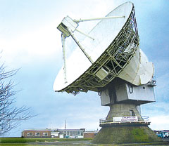
The antenna dish at Chilbolton Observatory.
The test campaign using the large antenna at Chilbolton Observatory to analyze the navigation signals transmitted by GIOVE-A, the first Galileo satellite, has been successfully completed, the European Space Agency (ESA) announced in mid-August.
Analysis of the satellite’s signals since January 2006, to verify their conformance with the Galileo system specification, has involved the Navigation Laboratory at ESA’s European Space Research and Technology Centre (ESTEC) in the Netherlands, the ESA ground station at Redu, Belgium, and the Rutherford Appleton Laboratory (RAL) Chilbolton Observatory in the United Kingdom.
Following signal analysis, operators have made some adjustments, re-programming the spacecraft’s navigation signal generation unit to compensate for changes to the signals introduced by the amplifier that boosts them for transmission to Earth and by a filter that protects adjacent frequency bands from interference.
To achieve the correct solution, the calibrated Chilbolton station was used to receive the signals from GIOVE-A. ESA’s Navigation Laboratory processed the resulting data. The signal generator manufacturer, TAS (France), calculated the new settings for the unit. Finally, the satellite manufacturer, Surrey Space Technology Limited (SSTL), uploaded the new values to the payload using their ground station at Guildford, in the United Kingdom.
According to ESA, “GIOVE-A is now transmitting optimized signals. Research and testing continues, and manufacturers are using the signals as they develop the receivers that users will need when Galileo enters operational service.”
Global Search and Rescue. Once operational sometime after 2012, Galileo will improve the detection of emergency beacons, according to program representatives whoattended the annual Joint Committee Meeting of COSPAS-SARSAT, the international program for satellite-aided search and rescue. Galileo satellites will carry transponders to relay distress signals to search and rescue organizations. Galileo partners have committed to developing a search and rescue component as an integral part of Medium Earth Orbit Search And Rescue (MEOSAR), the future worldwide search and rescue satellite system.
COSPAS-SARSAT already has systems operating in low-Earth orbit and geostationary orbit. The low-Earth orbit satellites can determine the location of emergency beacons using the Doppler effect as they pass overhead. However, there is a delay in relaying the distress signal because the satellites can only “see” a part of the Earth’s surface at any given time and a beacon is only detected when the satellite passes nearly overhead. Also, the satellites must store the location of the emergency and transmit it to a ground station once one comes into range, creating further delay.
Search and rescue transponders on geostationary satellites can constantly view a large, fixed area of the Earth, eliminating the time delay in detecting distress signals. However, they cannot automatically determine the location of the distress beacon as the low-Earth orbit system does, but must rely on the beacon to use a navigation system to find its position and include it in the distress call.
Emergency beacons require a direct line-of-sight to the geostationary satellites. There are some situations where this is impossible, such as near the Earth’s poles, where the satellites are too low in the sky, or when an accident occurs where surrounding terrain obscures the satellite.
Future Improvements. To improve performance of the overall COSPAS-SARSAT system, plans are now being made to fly search and rescue payloads on future navigation satellites. The various navigation satellite constellations will each have about 20 to 30 satellites in medium-Earth orbit, providing global coverage, including at the Earth’s poles, and with multiple viewing angles to the satellites, eliminating terrain blocking.
The Galileo search and rescue component will provide two services. The Forward Link Alert Service, backward-compatible with current COSPAS-SARSAT components and interoperable with all other planned MEOSAR elements, detects activated distress beacons and notifies the appropriate rescue body. A new Return Link Service will send a return message to the emergency beacon, notifying the emergency victims that their distress signal has been received and help is on its way.
The Galileo In-Orbit Validation Programme, which will have four satellites fitted with search and rescue transponders, will demonstrate the Galileo MEOSAR services — although its flight timetable has yet to be finalized or announced.
DOT Weighs NDGPS Future, Asks Public Input
The U.S. Department of Transportation’s (DOT) Research and Innovative Technology Administration (RITA) is preparing an assessment on the inland component of the Nationwide Differential Global Positioning System (NDGPS) that will determine its future.
As part of that assessment, it is seeking public input from users of the system.
The current expansion of the NDGPS has been placed on hold pending congressional review of the system’s funding; RITA’s assessment is part of that review. Differential GPS uses the fixed location of a reference station on the ground to improve the positioning resolution provided by civilian GPS satellite signals down to 1–3 meters. NDGPS facilities also monitor GPS satellites for anomalous behavior and issue integrity warnings when necessary.
The NDGPS program is operated jointly with the DOT’s Federal Highway Administration, Federal Railroad Administration, and Office of the Secretary of Transportation; the Department of Homeland Security’s U.S. Coast Guard; the Departmentof Commerce’s National Geodetic Survey and Forecast Systems Laboratory; and the Department of Defense’s Air Force and Army Corps of Engineers. Begun in 1997, to date there are 37 operational NDGPS sites. Two additional sites are ready for construction and could be operational in a matter of months, according to the Coast Guard.
As part of the assessment, RITA published a notice in the Federal Register addressing the current user requirements for the inland or terrestrial component of the NDGPS. This assessment is in preparation for making a recommendation to the National Space-Based Positioning, Navigation and Timing (PNT) Executive Committee, which oversees the entire GPS, on the need to continue to operate inland NDGPS and to make a decision on its future funding.
If no transportation requirements or other federal user requirements are identified as a result of the needs assessment, and if there are no other federal or other funding sources willing to sponsor or partner in sponsoring NDGPS, the DOT will develop a decommissioning plan for NDGPS, according to RITA.
The deadline for public comment is October 1, 2007. Comments may be submitted via the Internet at the Department of Transportation Web site. Instructions for other methods of submitting comments, including via postal service and fax, can also be found there in the docket management portion of the site.
The Robots of DARPA
The U.S. Defense Advanced Research Projects Agency (DARPA) has named 36 teams as semifinalists for its Urban Challenge to take place later this year.
The DARPA Urban Challenge will feature autonomous ground vehicles executing simulated military supply missions in a mock urban area. It will take place November 3at an urban military training facility located on the former George Air Force Base in Victorville, California.
The 36 semifinalists will compete in the Urban Challenge National Qualification Event (NQE), October 26–31. The top 20 teams from the NQE will move on to the Urban Challenge final event on November 3, and compete for cash prizes worth $2 million for first, $1 million for second, and $500,000 for third place.
At the NQE and the final event, the robots must operate entirely autonomously, without human intervention, and obey California traffic laws while performing maneuvers such as merging into moving traffic, navigating traffic circles, and avoiding moving obstacles. DARPA conducted competitive site visits across the United States to select the semi-finalists.
“The depth and quality of this year’s field of competitors is a testimony to how far the technology has advanced since the first Grand Challenge in 2004,” said DARPAdirector Tony Tether.
Stanford University’s winning robot vehicle from the last DARPA Challenge in 2005, which ran across the Mojave Desert, consisted of a stock Volkswagen Touareg R5 thatincorporatesd measurements from GPS, a 6DOF inertial measurement unit, and wheel speed for pose estimation.