Taiwan will launch its first indigenously developed meteorological satellite in March 2023, reports Taiwan News.
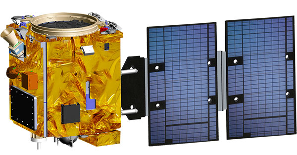
The Triton satellite was designed and made by the National Space Organization (NSPO) over eight years. The satellite has completed testing and is undergoing review.
The 250-kg Triton carries GNSS-reflectometry equipment (GNSS-R) — independently developed by NSPO — to collect GNSS signals reflected by the Earth’s surface. Its mission is to research air-sea interaction to help predict typhoons.
Taiwan is hit by typhoons every year. Information on wave height and sea-surface wind speed, retrieved from the reflected signals, will be useful for research on typhoon intensity and path prediction.
The satellite will be transported to the Guiana Space Center in January. It is scheduled to launch in March aboard a Vega C rocket manufactured by Arianespace.
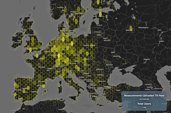
This graphic represents measurements uploaded via the CAMALIOT app by thousands of volunteers. (Image: ESA)
More than 11,000 people around Europe and the world have turned their smartphones into GNSS monitoring tools by downloading the CAMALIOT app, so far delivering more than 53 billion measurements of meteorology and space weather patterns to researchers, according to the European Space Agency (ESA).
ESA asks CAMALIOT volunteers to leave their smartphones by a window each night with GNSS on. The phones record small variations in satellite signals, gathering data for machine-learning analysis. More than 50 smartphone models with dual-frequency receivers can use the app.
CAMALIOT was developed through ESA’s Navigation Innovation and Support Programme (NAVISP) with the support of the agency’s Navigation Science Office through its GNSS Science Support Centre. The combination of GNSS data, smartphone access and machine learning in support of science is a priority research line of ESA’s Navigation Science Office.
GNSS signals undergo scintillation as they pass through irregular plasma patches in the ionosphere. This electrically charged upper atmospheric layer is continuously changing, influenced by solar activity, geomagnetic conditions and the local time of day. Dual-frequency GNSS receivers can compensate for this effect by comparing their two frequencies.
As these signals head to Earth, they are also modified by the amount of water vapor in the lower atmosphere, helping to forecast rainfall in particular.
“Fixed satnav stations already monitor these effects, but these smartphone-based measurements are boosting our coverage hugely. We’re very gratified by all the support we’ve received,” said Vicente Navarro, ESA navigation engineer. ”These results will then undergo a Big Data machine-learning analysis, seeking out previously unseen patterns in both Earth and space weather.”
Formally known as the Application of Machine Learning Technology for GNSS IoT Data Fusion project, CAMALIOT is run by a consortium led by ETH Zurich in collaboration with the International Institute for Applied Systems Analysis.
The Federal Aviation Administration (FAA) has selected Harris Corporation for an eight-year, single-award indefinite delivery/indefinite quantity (IDIQ) contract with a potential value of $238 million to design and implement a system that will disseminate real-time, comprehensive weather pictures to all aviation users across the National Airspace System.
The Common Support Services–Weather (CSS-Wx) program will help minimize flight delays and cancellations by providing additional weather data with increased accuracy to more aviation consumers, supporting real-time operational planning and decision-making.
“About 70 percent of flight delays are caused by weather,” said Carl D’Alessandro, vice president and general manager, Civil Programs, Harris Government Communications Systems. “The enterprise-wide, data-sharing design of the CSS-Wx solution will reduce these delays, saving the FAA and flying public precious time and money.”
The Harris CSS-Wx system is scalable, with Open Geospatial Consortium standards for common weather formats, and highly advanced geospatial- and temporal-based filtering methods to process meteorological data. It applies expertise the company has gained from work on mission-critical weather programs for the FAA, the National Oceanic and Atmospheric Administration and the Department of Defense.
Harris has a long history of developing and integrating system solutions for the FAA in support of the National Airspace System (NAS). The company is the prime contractor for the FAA Telecommunications Infrastructure (FTI) program, which provides critical voice, data and video communications for NAS operations and mission support functions. FTI securely connects more than 4,500 national and international FAA and DOD facilities, manages over 26,000 services, and supports more than 50,000 users. Other FAA programs developed by Harris include:
The Weather and Radar Processor, which provides weather processing dissemination and display capabilities to air traffic controllers in the en-route air traffic control environment;
Datacomm, which provides air-to-ground digital data link networks to connect FAA air traffic control sites and data communications-equipped aircraft;
The NAS Voice System, which provides a secure, IP-based voice network for critical communications between air traffic controllers, pilots and ground personnel nationwide;
The Operational and Supportability Implementation System, which serves the General Aviation community in Alaska by providing weather briefing and flight planning services; and
The National Air Space Enterprise Messaging Service, which will provide the FAA with the network-centric, collaborative information-sharing capabilities afforded by System Wide Information Management.