Tag: Mexico

  • Lidar helps uncover lost Mayan city

    Lidar helps uncover lost Mayan city

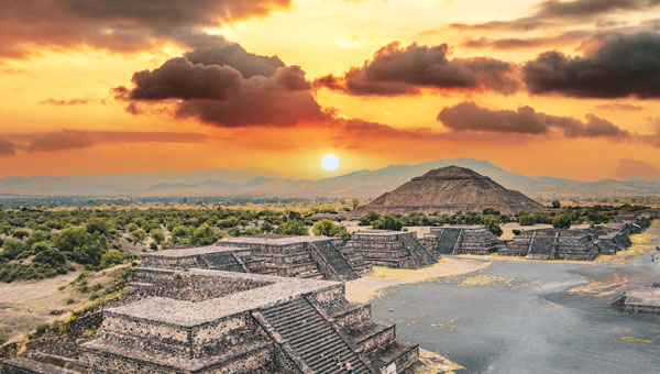
    A graduate student analyzing publicly available drone data in Mexico unexpectedly unveiled a vast ancient Mayan city hidden beneath a dense jungle in Campeche on the Gulf of Mexico. The findings, published in the academic journal Antiquity, reveal an extensive urban complex covering an area approximately one-and-a-half times the size of Washington, D.C.

    Luke Auld-Thomas, a Ph.D. candidate at Tulane University, stumbled upon this while browsing the internet, according to NBC News. The data, originally collected by a research group studying land-use patterns, was captured using UAV mapping technology and lidar. Auld-Thomas applied archaeological analysis methods to the survey data, leading to the identification of the ancient city.

    Unraveling the mystery

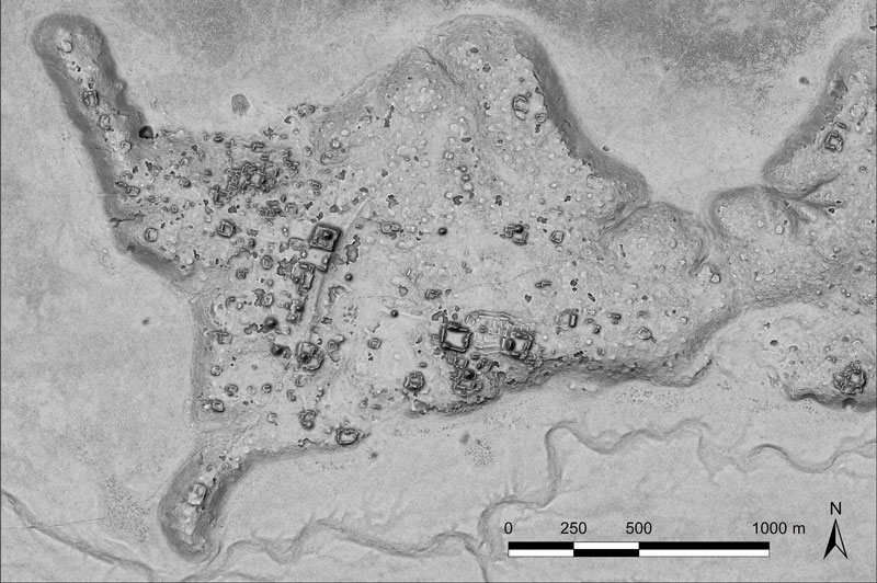
    The research team named the newly discovered city “Valeriana” after a nearby freshwater lagoon. This urban center consists of 6,674 structures, including pyramids reminiscent of those found at Chichén Itzá in Yucatan and Tikal in Guatemala. Valeriana likely housed between 30,000 and 50,000 inhabitants at its peak.

    Researchers believe Valeriana flourished during the Classic Maya period (AD 250 to 900) and likely collapsed between 800 A.D. and 1,000 A.D. The city’s decline is attributed to a complex set of factors, with climate change playing a significant role. Marcello Canuto, an anthropology professor at Tulane University, explained that climate variability caused stresses and adaptations, leading to systemic unrest in densely populated areas.

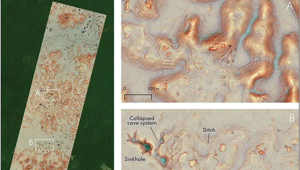
    Valeriana’s discovery highlights how surveys and lidar can be used in archaeological research. This newly adopted method uses laser pulses to penetrate forest canopies and capture detailed images of hidden landscapes. Canuto describes it as a form of “digital deforestation,” allowing researchers to uncover extensive, previously unseen layers of history in remote and inaccessible regions.

  • Seen & Heard: Lidar reveals Mayan city, UK begins UAV deliveries

    Seen & Heard: Lidar reveals Mayan city, UK begins UAV deliveries

    “Seen & Heard” is a monthly feature of GPS World magazine, traveling the world to capture interesting and unusual news stories involving the GNSS/PNT industry.


    UK begins UAV deliveries

    Image: Screenshot of video by BBC
    Image: Screenshot of video by BBC

    Royal Mail and UAV company Skyports have launched the Orkney I-Port operation to distribute letters and packages between the Orkney Islands, Scotland, reported the BBC. In partnership with the council’s harbor authority and Scottish airline Loganair, mail will be transported from Royal Mail’s Kirkwall delivery office to the city of Stromness in Orkney. UAVs will then carry items to the islands of Graemsay and Hoy, where postal staff will complete the delivery routes. The UAV service will initially operate for three months and may continue on a permanent basis under existing regulatory frameworks due to Orkney’s unique landscape and the proximity of the islands to one another. The UAV service aims to improve service levels and delivery times to Graemsay and Hoy, as weather and geography typically cause disruption to delivery services. The use of UAVs to deliver mail also may bring significant safety improvements by ensuring that postal workers can deliver between ports without risk.


    GNSS is taking a hike, literally

    Image: Aleksandar Georgiev/iStock/Getty Images Plus/Getty Images
    Image: Aleksandar Georgiev/iStock/Getty Images Plus/Getty Images

    In July, officials in Taichung City, Taiwan, launched a GNSS-based app to aid lost hikers and to mitigate risk associated with outdoor activities in the area’s mountainous region, reported Tapei Times. The app was developed by the Taichung Fire Bureau in response to a surge in outdoor activities after the COVID-19 pandemic restrictions were lifted and, subsequently, an increase in medical emergencies linked to mountain activities. Wi-Fi towers have been built at major trailheads such as Toukeshan, Anmashan, Fushoushan and Snow Mountain to supplement the app as well as to help facilitate UAV deployment to find lost hikers.


    Lidar reveals Mayan city

    Image: tobiasjo/iStock/Getty Images Plus/Getty Images
    Image: tobiasjo/iStock/Getty Images Plus/Getty Images

    In a biological preserve in Mexico’s Campeche state, a team of archaeologists have documented pyramids, palaces, a ball court and other remains of an ancient city they call Ocomtún, reported The New York Times. Archeologists surveyed the site for six weeks in May and June, finding 50-foot-tall structures resembling pyramids, as well as pottery and Mayan engravings they believe date to between 600 AD and 900 AD. The team determined the city was likely abandoned more than 1,000 years ago. Surveying of the area has been revolutionized over the past decade by lidar — allowing researchers to survey densely forested areas that are difficult to explore on foot. Archeologists were able to use airborne lasers to pierce through dense vegetation and reveal the ancient structures and human-modified landscapes beneath.


    Hundreds of UAVs down

    Image: Chesky_W/iStock / Getty Images Plus/Getty Images
    Image: Chesky_W/iStock / Getty Images Plus/Getty Images

    More than 350 UAVs were lost during a practice light display show in Melbourne, Australia, on July 14, ahead of a scheduled performance for the opening of the women’s World Cup. The UAVs appeared to stop mid-show and plummet into the Yarra River. Divers have since fished out hundreds of the UAVs. According to the Resilient Navigation and Timing Foundation, the likely cause of the mass-crash was interference with GPS signals.

  • Lidar reveals a hidden Mayan city

    Lidar reveals a hidden Mayan city

    A relief of the ancient Maya site archaeologists are calling Ocomtún. (Image: Žiga Kokalj/ZRC SAZU)
    A relief of the ancient Maya site archaeologists are calling Ocomtún. (Image: Žiga Kokalj/ZRC SAZU)

    In a biological preserve in Mexico’s Campeche State, a team of archaeologists have documented pyramids, palaces, a ball court and other remains of an ancient city they call Ocomtún, reported the New York Times.

    Archeologists surveyed the site for six weeks in May and June, finding  50-foot-tall (15.2-meter-tall) structures resembling pyramids, as well as pottery and Mayan engravings they believe date to between 600 and 900 AD. The team determined the city was likely abandoned more than 1,000 years ago.

    Mexico’s National Institute of Anthropology and History (INAH) hailed their findings late last month, saying they discovered the ancient city in “a vast area practically unknown to archaeology.”

    “I’m often asked why nobody has come there, and I say, ‘Well, probably because you need to be a little nuts to go there,” said Ivan Sprajc, the survey’s lead archaeologist and a professor at a Slovenian research center, ZRC SAZU. “It’s not an easy job.”

    Surveying the area has been revolutionized over the last decade by lidar — allowing researchers to survey densely forested areas that are difficult to explore on foot. Archeologists were able to use airborne lasers to pierce through dense vegetation and reveal the ancient structures and human-modified landscapes beneath.

    INAH described the site as having once been a major center of Mayan life. Surrounded by wetlands, Ocomtún includes pyramids, plazas, elite residences and “strange” complexes of structures arranged almost in concentric circles, Dr. Sprajc told CNN.

    “For example, we have several very curious architecture complexes of structures which are arranged in almost concentric circles. So, we are only guessing what this could be. Perhaps marketplaces,” he added.

    Mexico’s National Institute of Anthropology and History team plans to return next year for further investigation.

  • Arcturus VTOL UAS deployed with the Mexican Navy

    Arcturus VTOL UAS deployed with the Mexican Navy

    Arcturus-Jump-WArcturus UAV reports the Mexican Navy has deployed its T-20 Jump fixed-wing vertical take-off and landing (VTOL) UAV for unspecified operations in Mexico. The customer took delivery of the VTOL system in March.

    The announcement was made at AUVSI’s Xponential 2016.

    The T-20 Jump is a VTOL variant of Arcturus UAV’s catapult launched T-20 platform. It operates without any special launch or recovery equipment. Gross payload capacity is 60 pounds.

    The Mexican Navy configuration with an electro-optics and infrared (EO/IR) sensor has approximately 15 hours of endurance and a 75-mile data-link range. An EO/IR and EW capable version offers 11 hours of endurance. Mexico has operated a fleet of catapult launch T-20s since 2014.

    Arcturus has proposed the T-20 Jump VTOL platform for MEUAS III, the United States Special Operations Command‘s (USSOCOM’s) worldwide UAS services contract. Arcturus has also proposed a heavy fuel version of the T-20 Jump for the Royal Australian Navy’s Tactical Unmanned Aircraft Program.