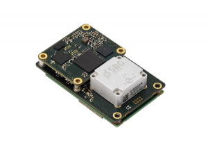
SBG Systems has released Quanta Plus, a GNSS-aided inertial navigation system (INS). Quanta Plus is a small, lightweight product, which can be easily integrated into survey systems with lidar or other third-party sensors.
The device combines a micro-electromechanical (MEMS) inertial measurement unit (IMU) with a resilient GNSS receiver to get reliable position and attitude, providing real-time kinematic (RTK) fixes.
Quanta Plus includes motion profiles, which enable users to optimize the sensor parameters to suit different use cases. The built-in precise time protocol server ensures sub-microsecond synchronization with external devices such as lidar. The device also has a built-in datalogger, Ethernet interface for easy integration, and a web configuration interface for simple setup and control.
The INS can be integrated with Qinertia, SBG System’s post-processing software. Qinertia improves the performance of acquired data during a mission using reliable RTK corrections from a wide range of continuously operating reference station networks, or by importing base-station data during the process.
Quanta Plus also improves the accuracy of the position and attitude using forward and backward processing and by integrating a tight coupling between GNSS and IMU data.
Quanta Plus is suitable for survey professionals or a navigation-dependent company seeking a robust navigation device. Specific solutions are available for integrators and OEMs who want to use Qinertia as a component in their application-specific data-processing solutions.
Inertial Labs has acquired Memsense, a developer of inertial measurement units (IMUs) and a long-time business partner. Inertial Labs is a developer and supplier of orientation, inertial navigation and optically enhanced sensor modules.
The Inertial Labs and Memsense workforce will address the rapidly evolving needs of global customers. The combined company of more than 100 employees and 500 customers expects to introduce breakthrough technologies at an accelerated pace across high-value areas such as autonomous vehicles, GPS-denied navigation, industrial machines, and aerospace and defense.
In addition, Inertial Labs and Memsense have a strong balance sheet to support critical business initiatives, deliver with short product lead times, and invest in promising integrations, the company stated in a press release.
“Our strategic acquisition of Memsense brings together two high growth companies with proven performance in solving some of the world’s most difficult stabilization and navigation problems,” said Jamie Marraccini, president and CEO of Inertial Labs. “Our customers will benefit from our combined capabilities and resources.”
“As we move forward, Inertial Labs and Memsense will define the future of MEMS IMUs,” said James Brunch, CEO of Memsense. “Our focus on innovation, our world-class team, and our strength in customer collaboration allow us to deliver the exact specs needed by our customers.”
Inertial Labs cites the following benefits for current and future customers:
increased production capabilities of up to 50,000 units annually to meet the needs of larger aerospace and defense contracts for guidance and navigation applications
low-cost, consumer-grade IMUs, ruggedized industrial-grade models, affordable tactical-grade IMUs, and IMUs with near-FOG level of performance (0.1 deg/h bias instability)
a larger range of devices for unmanned ground vehicles (UGV); unmanned aerial vehicles (UAV); autonomous and automated ground vehicles (AGV).
expanded research and development efforts to accelerate delivery of IMUs for stabilization applications, such as electro-optical systems, pan-and-tilt platforms, and remote weapon stations (RWS)
new IMU models with improved performance will increase capabilities of the company’s GPS-aided inertial navigation systems (INS), wave sensors, motion reference units (MRU) and attitude heading reference systems (AHRS)
development of new high-performance systems including a MEMS-based gyro-compasses (3 MILS azimuth and 1 MIL elevation accuracy).
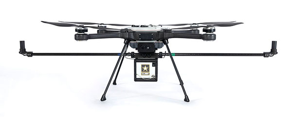
RedTail Lidar Systems has delivered six lidar systems to the 707th Ordnance Company stationed at Joint Base Lewis-McChord. The systems will provide explosive ordnance disposal (EOD) technicians an opportunity to assess how lidar can be used to enhance their operations.
The RedTail Lidar Systems RTL-450 was integrated onto the Teledyne FLIR SkyRaider unmanned aerial system (UAS) to address a broad range of the EOD community’s 3D mapping needs. Captain William R. Hartman, the commander of the 707th EOD Company, stated that the highlight of the testing was using the lidar system to map terrain.
The RTL-450 also can be used to calculate crater volumes from improvised explosive device (IED) blasts, perform route planning for unmanned ground vehicles, aid in mission planning, and conduct surveillance. The 3D point clouds generated allow operating areas to be viewed from any perspective using the rotation and zoom capabilities provided within the viewer software.
The underlying lidar technology used in the RTL-450 was licensed from the Army Research Laboratory (ARL). The micro-electromechanical (MEMS) mirror-based design provides enhanced 3D imagery suitable for applications where artificial intelligence and machine learning (AI/ML) algorithms can be used for target detection and classification, because of the high point density of the point clouds.
The system can operate in either a raster scan mode for surveillance missions or a side-to-side line scan mode for area mapping while the UAS is flying. The intuitive command and control, high brightness display integrated into the ground control station (GCS), and real-time 3D map generation allows operators to begin mission planning and analysis even before the mapping or surveillance missions are completed.
“Delivering these six lidar systems to EOD technicians for test and evaluation is a significant step forward in using MEMS mirror-based lidar technology to address a broad range of Department of Defense 3D mapping needs,” said said Brad DeRoos, president and CEO of RedTail Lidar Systems. In addition, this delivery represents a true success story in transitioning a technology out of a Department of Defense laboratory and back into the hands of military operators.”
KVH has been developing and testing the PIC technology for more than three years and is continuing to roll the technology into existing product lines.
KVH’s PIC technology features an integrated planar optical chip that replaces individual fiber optic components to simplify production while maintaining or improving accuracy and performance. KVH’s IMUs with PIC technology are designed to deliver improved bias stability and 20 times higher accuracy than other micro-electromechanical systems (MEMS) IMUs.
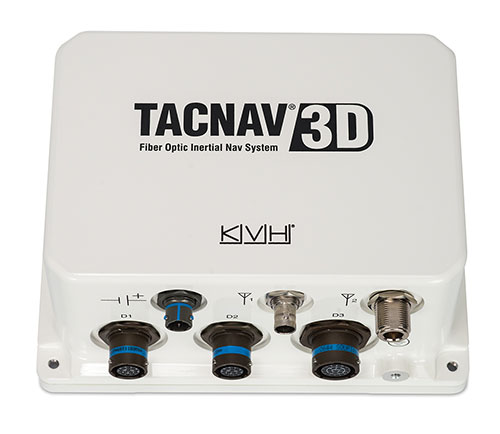
The fiber-optic gyro (FOG)-based TACNAV 3D tactical navigation system provides an assured positioning, navigation and timing (A-PNT) solution with an embedded GNSS and optional chip-scale atomic clock (CSAC). TACNAV 3D’s modular tactical design enables it to function as a standalone inertial navigation solution and as the core of an A-PNT-capable multi-functional battlefield management system.
“We are pleased to incorporate our newest technology into the TACNAV 3D,” said Dan Conway, executive vice president of KVH’s inertial navigation group. “We are committed to ensuring that this battle-proven system provides the precise navigation that is vital to mission success and addresses the military demand for assured positioning, navigation, and timing (A-PNT) solutions.”
KVH’s TACNAV solutions are being used in vehicles that operate in demanding environments, from battle tanks and M-ATVs, to armored vehicles, reconnaissance and combat support vehicles.
Defense forces using TACNAV systems include the U.S. Army and Marine Corps, as well as many allied customers including Australia, Botswana, Brazil, Canada, Egypt, France, Germany, Great Britain, Italy, Malaysia, New Zealand, Poland, Romania, Saudi Arabia, Singapore, South Korea, Spain, Sweden, Switzerland, Taiwan and Turkey.
Findings show accuracy of new sensors is improved by greater than an order of magnitude over current offerings.
Honeywell, with funding from the U.S. Defense Advanced Research Projects Agency (DARPA), is creating the next generation of inertial sensor technology that will one day be used in both commercial and defense navigation applications.
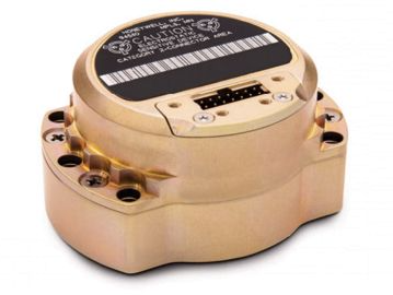
The HG1930 IMU. (Photo: Honeywell)
Findings gathered in Honeywell labs have shown the new sensors to be greater than an order of magnitude more accurate than Honeywell’s HG1930 inertial measurement unit (IMU) product, a tactical-grade product with more than 150,000 units currently in use.
An IMU uses gyroscopes, accelerometers and electronics to give precise rotation and acceleration data to enable a vehicle system to calculate where it is, what direction it is going and at what speed, even when GPS signals aren’t available.
There are various types of IMUs on the market, and some — like the next-generation version currently under development — use sensors based on micro-electromechanical systems (MEMS) technology to precisely measure motion.
“Typically, MEMS inertial sensors have been on the lower end of the performance scale, but this latest milestone shows we are changing that paradigm,” said Jenni Strabley, director of offering management for Inertial Sensors, Honeywell Aerospace. “With this next-generation MEMS technology, we’re increasing performance without having to significantly change the size or weight of the IMU. This is a game-changer for the navigation industry, where customers need highly accurate solutions but cannot afford to compromise on weight or size.”
Over the past few years, Honeywell has been working with DARPA to develop the next generation of high-precision navigation-grade IMU technology, under the Precise Robust Inertial Guidance for Munitions: Thermally Stabilized Inertial Guidance for Munitions program.
The new MEMS sensors will use different sensor designs and electronics to enable higher performance. They will serve a broad range of applications in autonomous land and air vehicles for both military and commercial customers, including future urban air mobility aircraft.
“Now that we have demonstrated that MEMS is capable of reaching these incredibly precise performance levels, it is the perfect time to start talking with potential users about how this technology could help their applications,” Strabley said. “We believe this new technology will have a variety of applications, such as onboard future vehicles that will fly in urban environments where lightweight, extremely precise navigation is critical to safer operations. Additionally, there are other applications that haven’t been invented yet but may be enabled by these types of technology innovations.”
Commercial sales of an IMU containing these next-generation sensors are still several years away, but one of the first products using this new technology is expected to be more than 50 times more accurate while roughly the same size as Honeywell’s IMU.
Honeywell has long been a pioneer in MEMS-based IMUs, including the HG1930. Honeywell’s lineage in navigation dates to the 1920s and since then Honeywell has developed and manufactured high-performance navigation solutions found on many aircraft and other vehicles worldwide.
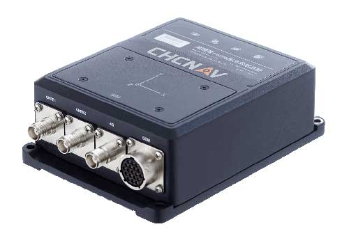
CHC Navigation has released the new CGI-610 GNSS/INS sensor, a high-precision dual-antenna receiver offering reliable and accurate navigation and positioning solutions for demanding land, marine and aerial applications.
The tight fusion of the latest GNSS technology with an industrial-grade MEMS IMU is powered by CHCNAV’s algorithms to deliver accurate hybrid position, attitude and velocity data, even in complex and obstructed environments where GNSS outages can occur.
The CGI-610 is a powerful GNSS/INS system supporting data output up to 100 Hz to meet the requirements of highly dynamic applications (including airplane, train and automobile). The optional external odometer sensor for ground vehicles can provide an additional independent measurement of displacement and speed, which is fused with the GNSS/INS navigation solution.
“The CGI-610 GNSS/INS sensor is the perfect answer to the growing demand of robust positioning and navigation systems for the control of any unmanned vehicle and machine, as well as for highly dynamic applications,” said George Zhao, CEO of CHC Navigation. “Industrial system integrators in need of a reliable GNSS/INS sensor with an exceptional price/performance ratio would definitely consider our CGI-610.”
With its 4G modem, CAN and serial ports, the CGI-610 GNSS/INS sensor offers unparalleled compatibility to enable a wide range of applications including machine control, port automation, advanced trajectography, robotics and unmanned vehicles. The CGI-610’s industrial design ensures reliable and consistent operation in the harshest environments.
Garmin International Inc., a unit of Garmin Ltd., has chosen SiTime’s micro-electromechanical system (MEMS) timing solutions for several of Garmin’s automotive, aviation, marine, fitness and outdoor products.
“Garmin makes products that are engineered on the inside for life on the outside,” said Patrick Desbois, Garmin executive vice president of operations. “Our innovation focuses on developing technologies that enable our customers to enrich their experiences as they pursue their passions. SiTime’s MEMS timing solutions help extend battery life across several of our product lines.”
SiTime timing solutions are the heartbeat of customers’ electronic systems. With the deployment of 5G, internet of things (IoT) and automotive electronics in challenging outdoor environments, manufacturers will need timing solutions that enable environmental robustness and solve difficult challenges, such as power, size, and reliability. With the proliferation of electronic devices, the timing market is expected to grow to $10.1 billion by 2024.
“Garmin creates products for active people,” said Piyush Sevalia, executive vice president of marketing at SiTime. “Precise time is at the heart of every GPS receiver and impacts the speed of signal acquisition as well as position accuracy.
“Garmin’s outdoor products encounter many environmental stresses such as shock, vibration, rapid temperature changes and extreme temperatures. SiTime’s MEMS timing solutions are engineered to provide the highest level of robustness to such stressors and provide a powerful value-add to Garmin’s high-performing, robust and reliable products.”
STMicroelectronics is offering new high-stability MEMS sensors for the Industrial Internet of Things (IIoT).
The new sensors, to be made available sometime this year, begin with the IIS3DHHC, a 3-axis accelerometer optimized for high measurement resolution and stability to ensure accuracy over time and temperature.
The IIS3DHHC targets precision inclinometers in antenna-positioning mechanisms for communication systems, Structural Health Monitoring (SHM) equipment for keeping buildings and bridges safe, and stabilizers or levelers for a wide variety of industrial platforms.
Its long-term accuracy and robustness are also suitable for high-sensitivity tilt and security sensors, as well as image stabilization in high-end digital still cameras (DSCs), the company said.
STMicroelectronics also provides what it calls “product longevity” to assure long-term availability of components in industrial equipment.
The IIS3DHHC has a full scale of ±2.5 g and is capable of providing the measured accelerations to the application through an SPI 4-wire digital interface.
The sensing element is manufactured using a dedicated micromachining process developed by STMicroelectronics to produce inertial sensors and actuators on silicon wafers.
The IC interface is manufactured using a CMOS process that allows a high level of integration to design a dedicated circuit which is trimmed to better match the characteristics of the sensing element.
The IIS3DHHC is available in a high-performance (low-stress) ceramic cavity land grid array (CC LGA) package and can operate within a temperature range of -40 degrees Celsius to +85 degrees Celsius.
Key Features of the IIS3DHHC
Included in the 10-year longevity program
3-axis, ±2.5 g full-scale
Ultra-low noise performance: 45 µg/√Hz
Excellent stability over temperature (<0.4 mg/°C) and time
16-bit data output
SPI 4-wire digital output interface
Embedded FIFO (depth 32 levels)
Embedded temperature sensor
12-bit temperature data output
High shock survivability
Extended operating temperature range (-40 °C to +85 °C)
ECOPACK, RoHS and “Green” compliant
“These high-quality industrial sensors leverage our investments in MEMS design and high-yield fabrication processes to deliver superior performance with low ownership costs for applications where the highest precision, repeatability and robustness are critical,” said Andrea Onetti, group VP and general manager, MEMS Sensors Division, STMicroelectronics. “We will continue to introduce new types of precision sensors for industrial applications in the coming months, covered by our 10-year longevity commitment, including combination sensors, specialized sensors and complete inertial modules.”
The IIS3DHHC is in production now, in a high-quality 16-lead 5 mm x 5 mm x 1.7 mm ceramic LGA package, priced from $4.50 for orders of 1000 pieces.