Tag: mines

  • 2G Robotics laser systems aid in Norwegian mine countermeasures

    The first of four ULS-500 PRO laser scanning systems from 2G Robotics has been shipped to Kongsberg Maritime for integration into the Norwegian Defence Materiel Agency’s (NDMA) newly purchased Hugin autonomous underwater vehicles (AUVs).

    The acquisition signifies the Royal Norwegian Navy’s transition to autonomous systems for mine countermeasures. During operations, Hugin AUVs will be used to complete surveys of subsea environments focused specifically on locating and identifying mines.

    The Hugin systems enable users to conduct fast and efficient operations with zero surface visibility while additionally improving safety conditions by allowing personnel to remain outside the minefield. In peacetime, the AUVs contribute to hydrographic operations.

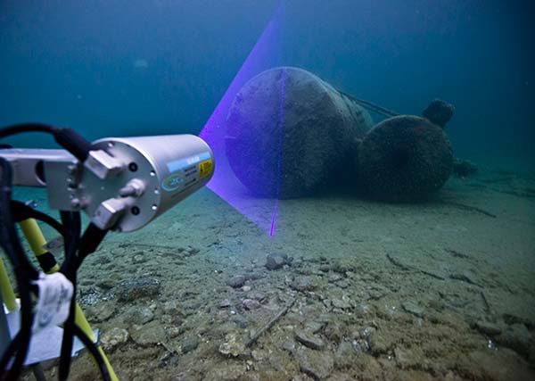
    The ULS-500 PRO dynamic underwater laser scanner system will contribute to the detection, classification and assessment of mines. 2G’s system acquires data in real time and provides users with 3D models of targets and environments accurate to the sub-centimeter.

    The complete laser scanning system also includes the 2G Observer, an ultra-sensitive stills camera able to capture images at 12 fps, and the 2G Nova, an LED panel designed specifically for AUV integration providing almost 1,000,000 lumens.

  • Kenya maps mines with Correlator3D

    The Kenyan government will be using SimActive’s Correlator3D to map mining activities. The software will be used to generate orthomosaics, contour lines and digital terrain models of fluorspar mines in the Kerio valley in Kenya.

    The Directorate of Resource Surveys & Remote Sensing (DRSRS) under the Ministry of Mining in Kenya chose the software.

    “The DRSRS provides the Ministry of Mining with spatial information, processing hundreds of images to visualize settlements affected by mining activities to advise the Government of Kenya on compensation plans,” said Charles Situma, deputy director of the project. “SimActive’s availability of experts internally allows us to receive tailored solutions to our requests, further expediting our processing.”

    “We are proud to have Kenya as another of our many government users,” said Dr Philippe Simard, President of SimActive. “Correlator3D provides the diverse tools and processing power required for intensive mining applications.”

  • Carlson GIS360 for Android Gives 3D Views on Site

    Carlson GIS360 Android app.
    Carlson GIS360 Android app.

    Carlson GIS360 for Android, new from Carlson Software and Carlson EMEA, is a mobile field GIS-GPS tool that uses both GIS and surveying technologies for field data collection. The app is designed to be easy to learn and easy to use, Carlson said.

    “Taking advantage of the graphics processing power of Android devices, GIS360 now includes an innovative 3D viewer so the user can see data and models in 3D on site,” said David Loescher, Carlson U.K. sales director and director of GIS360 development.

    In addition to allowing field crews to navigate maps and collect and report data in the field, GIS360 provides the data and fully rendered models of mines, earthworks and pipe networks that can be viewed in 3D. The software’s Siteview function uses the Android devices’ built-in GPS, compass and gyros to give the user the view of the site in front of him.

    Carlson GIS360 provides a wireless connection to any map server of choice, so users are never without a map. This saves considerable time and effort as field crews can verify that all of the data collected is accurate before leaving the site, Carlson said. No costly site revisits are necessary and no office work is needed.

    The software’s cloud options provide backup for users’ data, enabling it to be shared between field and office in real time. GIS360 goes beyond positioning with a range of tools for mobile workforce management, GPS data collection, tracking and asset maintenance.

    On an Android tablet or smartphone, Carlson GIS360 for Android can take GIS data anywhere. The built-in GPS and compass instantly calculate what the user is looking at and then displays the data automatically.

    “The GIS360 development team set out to make the collection of asset information easier and more efficient by combining the power of GIS360 with affordable Android devices,” added Loescher. “The result not only saves a lot of field time, but also makes the process far easier for everyone concerned.”