What works well and what needs improvement in the GPS program regarding technology, policy, or management?
Jules McNeff
“GPS technology and operational performance continue to set the standard for GNSS, but necessary modernization is late to need, and becoming later by the day. This reflects what I see as loss of focus on ‘Job 1’ (delivering effective GPS service to the Joint Force) and a diminution in the sense of ‘GPS uniqueness and exceptionalism’ in its management as it was fragmented within the old SMC and is no longer the ‘shiny new object’ within the evolving Space Force. Even so, its value to its global user base, and particularly to U.S. and allied militaries, is stronger than ever and it remains the cornerstone among diverse complements within the Department of Defense PNT Enterprise. It is incumbent on the DOD to ensure the GPS services our warfighters will depend on can sustain that vital role.”
— Jules McNeff Overlook Systems Technologies
Ellen Hall
“What works well? There is good focus on the areas that need development: M-code, CRPA, resiliency. What needs improvement? More thorough and timely sharing of information by the government with industry.” — Ellen Hall, Spirent Federal Systems
Mitch Narins
“The ‘GPS program’ has set the standard for all other GNSS efforts, but there are always lessons to be learned. I have full confidence that USSF leadership is well equipped to deal with both the technology and management aspects of the program. As for policy, which supports military and civil uses worldwide, there is a clear distinction, based on mission areas and acceptable risk. However, risks to civil users have increased as GPS PNT services permeate all civil critical infrastructure systems. Therefore, system improvements directed at civil user PNT resilience should be given a higher priority and funded through appropriate civil channels. I encourage a policy to enable more resilient PNT services from space — and to consider that by looking both ‘up’ and ‘down’ for PNT services, unfortunate ‘situations’ might be avoided.” — Mitch Narins,
Strategic Synergies
Bernard Gruber
“One of the most consistent and enduring enablers of the GPS program is national policy. NSPD-39 re-baselined requirements buttressed by GPS being provided to the world for free, that it must be sustained and have an ever-present focus on performance improvement and robustness. Accordingly, NSPD-7 acknowledges an ever-changing world with a nod to cybersecurity, augmentations and direction to “improve NAVWAR capabilities to deny hostile use of United States Government space-based PNT services, without unduly disrupting civil and commercial access to civil PNT services.” — Bernard Gruber,
Northrop Grumman
Achieving PNT resilience for critical infrastructure applications
GNSS are magic. They are. One dictionary defines magic as “a power that allows people (such as witches and wizards) to do impossible things by saying special words or performing special actions.” By this definition, we have all become witches and wizards, doing what previous generations would have deemed impossible.
This magic, however, can be affected by external forces that render it useless at best and, at worst, dangerous. Warnings about GNSS positioning, navigation and timing (PNT) service vulnerabilities have been raised for 25+ years. Numerous organizations have warned of the potential safety, security and economic impacts of GNSS interference. Still, like modern-day Cassandras, their warnings have been ignored, and sole use of PNT services that rely on space-based signals continues to expand.
“Magic services” are addictive and cannot be ignored. Yet, it is well past the time to merely admire the problem of GNSS interference — benefitting from magical GNSS services while ignoring existing and emerging threats and challenges. It is time to draw a line and implement resilient, complementary PNT solutions to support all critical infrastructure sectors and applications in the event of any GNSS disruption, due to jamming or spoofing or systemic causes. “Magic” is magical when it works. When it does not, first and foremost, it should “do no harm.”
Threats, Challenges and Needs
Presidential Policy Directive (PPD) 21, Critical Infrastructure Security and Resilience,issued in 2013, defines resilience as “the ability to prepare for and adapt to changing conditions and withstand and recover rapidly from disruptions.” It also notes that “resilience includes the ability to withstand and recover from deliberate attacks, accidents, or naturally occurring threats or incidents.”
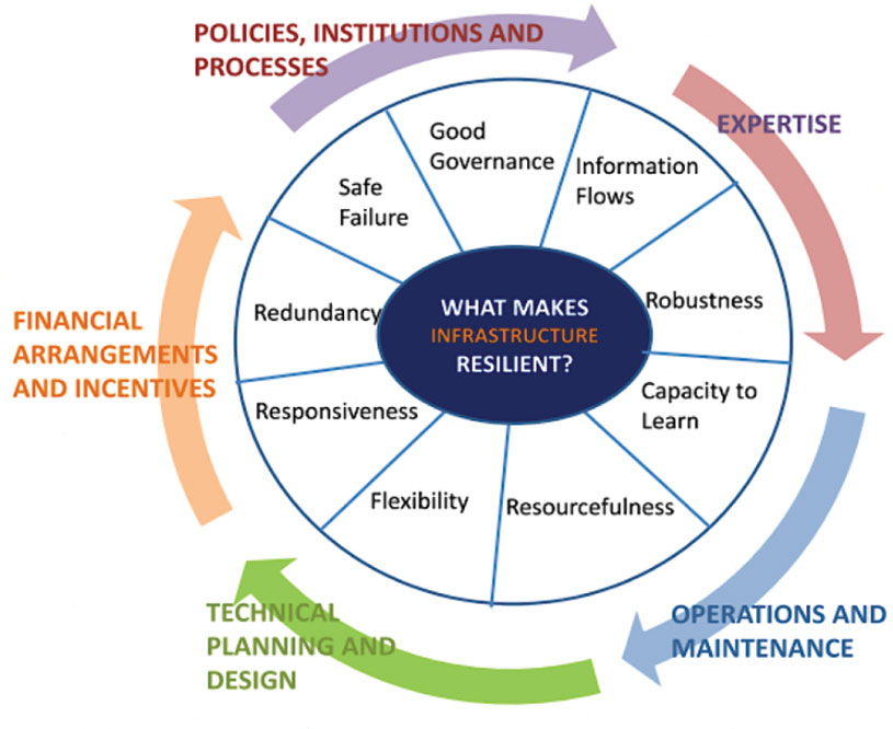
In 2016, the UK Department of International Development noted that “Resilience covers both ‘physical and societal systems” through four “R” principles: robustness, redundancy, resourcefulness and rapidity (see Figure 1).
Figure 1. Infrastructure resilience properties. (Image: UK Department of International Development)
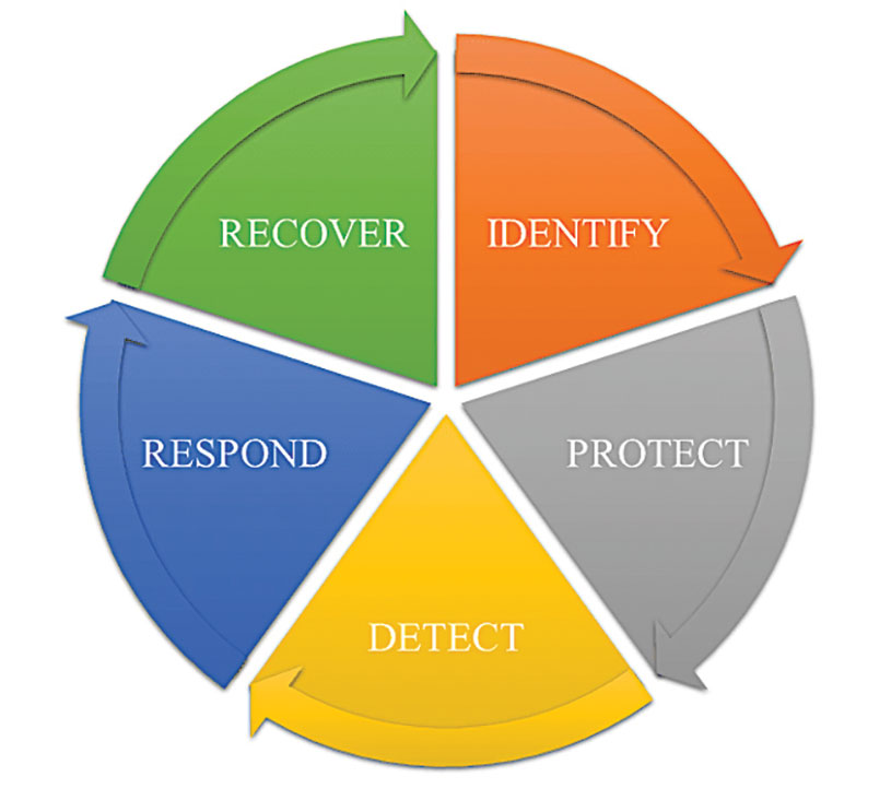
More recently, Andy Proctor (RethinkPNT) pointed out that “A resilient PNT system protects its critical capabilities (assets) from harm by using protective resilience techniques to passively resist or actively detect threats, respond to them, and recover from the harm they cause.”
Policies, processes, financial arrangements and incentives are also crucial to achieving resilience — and that has been, and remains, the problem. Lacking the emergence of strong leadership from our institutions, the ability to achieve actual resilience will continue to falter and admiration of the problem will continue.
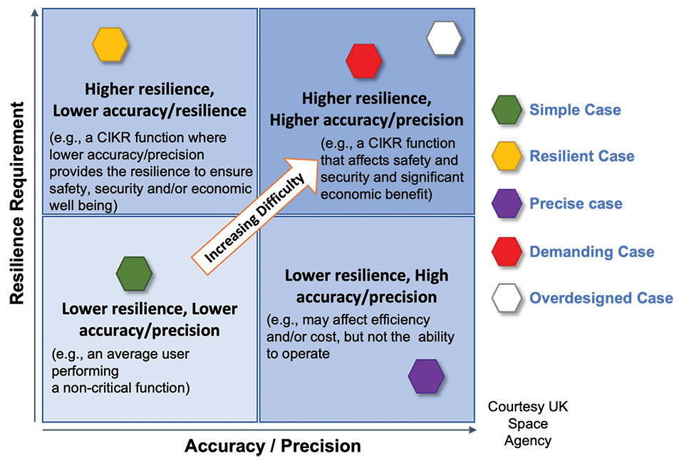
Developing a resilient PNT system is always a balance of technical complexity and non-technical aspects, for example, costs. The key consideration for users must be the required performance metrics they need for their use-case(s) to ensure their resilience — including accuracy, availability, integrity, continuity and coverage. The one least understood and many times omitted is integrity — the level of trust a user/use-case needs to safely and securely use the PNT services. The ability to trust PNT services must always be a consideration for critical infrastructure applications.
Unfortunately, many users of critical infrastructure PNT do not know some of the PNT metrics they need to ensure safety and security. More troubling, there is no guidance as to what constitutes “significant economic impact” (see PPD 21) or acceptable economic loss — and over what period or range of use cases. This understanding will require analysis of their design, development and operational experiences, and working with PNT systems engineers to first derive these metrics and then drive the continuous improvements (see Figure 2) needed to achieve and retain truly complementary PNT capabilities. Without clear metrics and guidance, one cannot claim that any solution will meet any “required level of resilience.”
Figure 2. Resilient PNT lifecycle.
Supporting PNT Users
As with all systems engineering (SE) activities, PNT system resilience begins with identifying and documenting user needs based on their specific user stories/use cases. Figure 3 depicts different aspects of resilience that can be sought, depending on the unique use-case “demands.”
Figure 3. Resilience aspects. (Photo: UK Space Agency)
While the resilience needs of different use cases will differ, for any specific use case, a given “PNT solution” will either achieve the required/threshold level of resilience (based on the operational environment) or it will not. Some use cases may also require fail-safe or fail-soft capability and the ability to recover to known, trusted and usable states. Shouldn’t many, if not all critical sector use cases require this?
Equally important is the identification of risks and threats, as they are critical to understanding the challenges that the system must face while continuing to provide the necessary P, N and/or T service performance. It is also key to understand and document the system architecture and environment in which it must perform. With knowledge of a user’s needs, the threats, hazards and challenges they face, and the system architecture, the SE process can develop an understanding of the “gaps” that exist and of the levels of risk they impose on a critical infrastructure system’s functional, physical and operational performance. Understanding this, essential use-appropriate mitigations can be identified, or if need be, developed, and a resilient, solution-agnostic PNT requirement document created.
The Way Forward
The Critical Infrastructure Resilience Institute (CIRI), a U.S. Department of Homeland Security Center of Excellence, notes that “critical infrastructure systems are facing a myriad of challenges. Solutions must address the cyber, physical and human dimensions.” They keyed into four areas where critical infrastructure resilience activities should be directed: building the business case, information policy and regulation, developing new tools and technologies, fostering and educating the workforce.
These include the recognition that “policy and regulation have a powerful impact on market forces.” While the fact that “most U.S. infrastructure is owned and operated by the private sector” is a challenge, it should not be an excuse.
We must start immediately to re-establish strong SE practices, policies, and principles to help critical users understand their needs and determine the metrics required to ensure safety and “preclude significant economic impact.” Only then can we understand from a national perspective, the needed safety and security metrics and what constitutes significant economic impact, and then establish categories of solution-agnostic requirements. Lacking these clear resilience targets, detailed planning, and required resource commitments, the growing threats of PNT vulnerability will continue only to be admired, rather than be mitigated. Hope is not a strategy, but this systems engineer hopes that it does not take a truly catastrophic event to finally prompt much needed and long overdue actions.
Mitch Narins is the principal consultant/owner of Strategic Synergies LLC, a consultancy he formed following more than 40 years of U.S. government service. He is a Fellow of the Royal Institute of Navigation, a aenior member of the Institute of Electrical and Electronic Engineers, a member of the Institute of Navigation and head of its Washington, D.C., section, and a member of RTCA, RTCM, IEEE and SAE Standards Committees.
Photo: Stanislav Ostranitsa/iStock/Getty Images Plus/Getty Images
Is Russia’s recent threat to destroy GPS satellites technically realistic? Specifically, how many satellites would it have to destroy to essentially incapacitate GPS-dependent U.S. weapons systems? Would the 1,100-km separation between the orbits of GPS and GLONASS satellites spare the latter from the debris field?
Ellen Hall
“It appears technically possible because they destroyed one of their own retired Soviet satellites on Nov. 15 with anti-satellite technology. Russia threatened to destroy up to 32 satellites, which would incapacitate GPS-dependent weapons and create a virtual mine field of debris with little ability to project trajectories of debris fallout. It is imperative that LEO and ground-based sensor alternatives be developed that will make an enemy attack less likely to be incapacitating.” — Ellen Hall, Spirent Federal Systems
“Some still appear to believe that the number of satellites and their orbital height offer some level of protection. They refuse to look to the ground for resilient solutions using proven and highly reliable technology — which, coincidently, both Russia and China continue to operate as their resilient PNT solutions. The United States and its allies cannot continue to be dictated to by financial analysts who resist these solutions for fear of exposing the poor decisions they supported in the past and continue to support regarding a solution with a higher power and low frequency.” — Mitch Narins, consultant
Bernard Gruber
“Yes, it is technically realistic, but this act of war against a truly worldwide utility would be politically and economically disastrous. GPS IOC was based upon 24 MEO satellites that offered full, but not overlapping, worldwide coverage with spares — there are now 31 satellites that can be utilized through the control segment. The GPS constellation is ~1,100-km deeper than GLONASS. As made evident by the now-destroyed Kosmos 1408 debris cloud simulations, and the actual debris cloud spread by the Chinese 2007 ASAT test that now encompasses most of the LEO regime, the debris field will expand, thus increasing risk to GPS satellite placement and possibly risking physical damage to currently orbited satellites.” — Bernie Gruber, Northrop Grumman
How will widespread deployment of 5G most benefit GNSS?
Greg Turetsky
“The connectivity options that widespread 5G offer will accelerate multiple GNSS benefits. The high bandwidth is starting to encourage many into the RTK domain, but I think the bigger opportunity may come from the low power versions that enable IoT applications. The combination of the ubiquity of cellular connectivity with the low power of NB-IoT could truly accelerate the real time asset management sector all the way down to the package/pallet level.” — Greg Turetzky
Allison Brown
“Widespread deployment and adoption of 5G is likely to continue to increase the demand for spectrum as broadband access continues to expand. The recent FCC decision allowing Ligado to operate terrestrial networks in bands near GPS is likely not the last decision that will result from this increasing demand. It is not clear to me that 5G deployment will ‘benefit’ GNSS and chipset vendors may need to prioritize developing products that have improved robustness in the presence of nearby interference.” — Alison Brown
Miguel Amor
“The benefit of 5G will be seen in the long term, when 5G ranging capability is available. Hybrid positioning algorithms using both 5G and GNSS observations will provide significant positioning benefits in challenging urban environments and seamless navigation between indoor and outdoor environments. Applications across markets will see the benefits of hybrid 5G and GNSS navigation, but the real advantage lies in how this hybrid will enable the future of autonomous mobility. We will see both technologies working closer together to deliver a seamless and ubiquitous positioning solution.” — Miguel Amor
Mitch Narins
“Like communications, the ability to precisely and securely position and navigate is an essential part of 21st century life. Together they must support both critical and non-critical operations. This requires finding a common understanding of spectrum needs and how to have the best of both. In the long run, end runs by either side may achieve myopic goals but will damage society. The problem is crying out for an enterprise-level systems engineering leadership that can plot our future spectrum course. Else, the push for spectrum will continue, fueled by ‘entrepreneurial spirit’ and often a lack of understanding of the importance of other spectrum uses.” — Mitch Narins
What is your pet peeve about how GPS/GNSS is portrayed or discussed in the media and popular culture?
Terry Moore, professor emeritus, University of Nottingham
“What really annoys me is the misinformed assumption that SatNav and GNSS are one and the same. There is now a proliferation of ‘Do Not Follow SatNav’ signs [in the United Kingdom], and so many anecdotal stories about accidents caused by drivers blindly following SatNavs in their vehicles. These are almost always due to the deficiencies of the mapping and the route guidance components of the SatNav systems and not due to any problem with GNSS whatsoever. Nevertheless, it is GNSS that takes the blame.”
Terry Moore University of Nottingham
Julian Thomas Managing Director
“In films, you often see what looks like the tracking of a person inside a building using GPS. Yet, this cannot be done currently with satellites and the kind of technology that can track people or objects indoors is highly specialized and localized to that environment.”
Julian Thomas Racelogic Ltd.
Stuart Riley, vice president of GNSS technology, Trimble
“My pet peeve is the oversimplification of consumer navigation issues. I ran a few searches for ‘GPS fails’ and almost immediately saw images of cars in water and stuck in narrow streets. All too often, this is attributed to a GPS issue or failure. From a consumer perspective, the overall system from maps to satellites is considered GPS. The reality is that GPS (the satellites and control segment) is extremely reliable. Historically, satellite issues have been minimal. The most likely navigation errors are routing errors and old or erroneous maps, coupled with users blindly following the directions, and, to a lesser extent, receiver design issues (e.g., lack of ICD compliance) and harsh conditions (deep urban canyons).”
Stuart Riley Trimble
Mitch Narins
“For many, GPS/GNSS remains the miracle cure for all that ails you — for position/surveillance (e.g., ADS-B), for navigation (RNAV and RNP), and for the largest user base, time and frequency. Even while acknowledging the risks, many still treat GPS/GNSS interference as the 500-year flood that will ‘never’ happen in their lifetimes and, if it does, can be excused away as force majeure. It seems that in most of the articles I read it is always a sunny day and GPS/GNSS works perfectly. The need to incorporate resiliency is never emphasized. Nobody would buy a car without a spare tire. Isn’t it time for GPS/GNSS users to recognize the need and insist that an appropriate PNT ‘spare’ be included in the deal?”
Mitch Narins Consultant
Headshot: F. Michael Swiek
“We can chuckle while watching spies, super sleuths, and adventurers receive GPS positions in incredibly challenged environments — even in caves. My main beef is that nowhere is any mention made of who operates GPS. Instead, GPS is treated as an assumed given, embedded in a smart device, constantly and reliably available on demand anywhere and under all conditions. It is about time recognition and credit is given to those who actually make the miracle of GPS happen.”
Mitch Narins, principal consultant & owner, Strategic Synergies LLC
Recently there have been conversations within the world’s position, navigation and timing communities regarding the use of the term “Gold Standard.” Many systems aspire to be a Gold Standard, but what does this mean and how should one rightfully claim this meritorious distinction? For me, to be called a Gold Standard, a system must meet a number of hard and soft performance requirements that instill users with trust and confidence. What are these performance metrics., and how should we measure them?
I propose that for a PNT system to be a Gold Standard, it must embody and embrace three basic operational aspects in its vision, mission and goals, which drive its design, development and operation:
Requirements. First, a PNT Gold Standard system must have clear, concise, published and independent operational requirements, established through recognized and appropriate standards — that is, the PNT “promises” of accuracy, availability, integrity, continuity and coverage provided by the system are available to all users, and any changes to these “performance requirements” are communicated and implemented in a formal and transparent process.
Monitoring. Next, a PNT Gold Standard must continuously monitor the system “health” to ensure that it is meeting all of its promised requirements (accuracy, availability, integrity, continuity and coverage). The measurements and monitoring information must be available to all users so they can, with confidence, independently verify performance in support of their missions and needs.
Transparency. Finally, and most importantly, a PNT Gold Standard must not only maintain transparency during normal operations, but at the most crucial times when the PNT system is not meeting its promised performance. When “things go wrong,” user communications and constant, continuous, and reliable information flows are essential to retaining trust (that is, the measure of the system operator’s integrity). “We don’t know what happened yet, but we will let you know as soon as we do” is acceptable; saying “no comment” is not. As soon as the cause of the problem is known, it must be promptly shared, in detail, along with the schedule for restoration of normal operations. All changes that will be implemented to preclude such an occurrence in the future and all lessons learned must also be communicated openly and honestly to users.
So, what is a PNT Gold Standard? It is a system that makes operational promises based on known and controlled standards and requirements and openly shares how performance against those promises is being monitored and assured. It is a system defined by mission, values, standards and operating principles that is committed to free and open communications when promised performance is being met and when it is not. It is a system that transparently documents, communicates, investigates and reports health and status to users without delay. It is a combination of known, measured and exceptional performance provided by a system operated with open, honest, inclusive, transparent and complete communications that evoke user trust. For me, that is what it means to be a PNT Gold Standard.
Mitch Narins is the principal consultant and owner of Strategic Synergies LLC, a technical and management consulting firm that he formed after retiring following over four decades of U.S. government service. He worked at the Federal Communications Commission as an acquisition engineer for the Field Operation Bureau; supported the U.S. Navy and U.S. Marine Corps as branch chief for Data Terminal Systems and Electronic Warfare Systems; and served more than 26 years at the Federal Aviation Administration as a program manager, systems engineer, and finally as the chief systems engineer for navigation.
At the FAA, he was integrated into all aspects of aviation sector position, navigation and time systems engineering, standards development, and enterprise architecture efforts in support of the National Airspace System and the Next Generation Air Transportation System (NextGen).
Narins is a recognized position, navigation, and timing (PNT) expert, who has published numerous articles and delivered many papers at conferences and seminars worldwide. He is a Certified Information Systems Security Professional (CISSP), a Fellow of the Royal Institute of Navigation, an active member of the Institute of Navigation (ION), and a member of RTCA, RTCM, and SAE Standards Committees. He is a recipient of ION’s Norman P. Hays Award and the International Loran Association’s President’s Award and Medal of Merit.
Stuart Riley
Stuart Riley is vice president of GNSS technology responsible for GNSS signal processing and products for several Trimble business areas. In this role, he is responsible for the core GNSS technology from signal reception through to the measurement engine that is used in all Trimble GNSS precision products. He oversees GNSS product development for Trimble’s GNSS Real-time Networks, Geospatial, Heavy Civil Construction and InTech OEM Divisions.
Beginning his career at Trimble in 1995, Stuart has worked on GNSS receiver development in various engineering roles, in addition to holding several management roles. He holds several patents filed and pending in the field of GNSS and is often a guest speaker at international conferences.
His research interests include improving GNSS performance in harsh environments, and taking measurements from additional sensors along with optimizing the GNSS receiver architecture, especially for the newer GNSS signals BeiDou, Galileo, IRNSS, QZSS and next-generation GPS and GLONASS signals.
Riley has an electronic engineering Ph.D. in the field of GNSS from the University of Leeds in England. After he graduated, he was a research fellow at the university on a European Space Agency-funded project to develop a prototype GNSS receiver for space applications.
Leaders in the GNSS/PNT community are reacting to the Federal Communications Commission (FCC) decision to approve an order to allow Ligado Networks to deploy a low-power nationwide 5G network. The departments of Defense and Transportation have criticized the decision, concerned about interference with GPS signals.
Below are statements we have received from our readers.
Logan Scott, LS Consulting
Logan Scott
Spectrum regulation is much like land use zoning in that certain services are kept separate so as to avoid disturbing the neighbors. The FCC has in effect allowed Ligado to build an outdoor concert venue next to a monastery and by way of compensation, they offer free earplugs. GPS / GNSS signals are extremely weak and the receivers are extremely sensitive. To give some perspective, by the time they get to the GPS receiver, GPS signals are about a factor of 20 less powerful than cosmic background noise. Ligado’s spectrum is/was licensed for mobile satellite services (MSS) and so was not likely to interfere with GPS.
With their new, and much more valuable license, Ligado now has a legal right to build a terrestrial cellular service. Exhaustive testing over the last 10 years has repeatedly demonstrated that such a system will interfere with high precision GPS/GNSS receivers used in surveying, timing, and earth observation. The DoD has also made strong claims that such a system will cause harm to their systems. In all cases, the effect is much like riding a bicycle at night. You can see fine until someone comes around the corner with the high beams on and blinds you.
The FCC has in effect allowed Ligado to build an outdoor concert venue next to a monastery and by way of compensation, they offer free earplugs.
In their earlier filings, Ligado had asked for permission to transmit at a power level of 1500 Watts. In an amazing piece of legerdemain, they convinced the FCC, but not the DoT or DoD, that by reducing transmit powers to 10 Watts, there would be no harm. This is a stunningly erroneous claim. As you lower the transmit power, you need many more cellular basestations to cover a given area. To use an analogy from my backyard, I can install one high flow sprinkler head to cover the entire yard or a bunch of low flow heads, each covering a small portion. Either way, the grass doesn’t care about anything other than inches of water and I’m gonna get wet if I run across the yard. Ligado’s core argument is equally wet. Nonetheless, it has great appeal to people who don’t understand how cellular systems work.
So, moving forward and assuming the license stands, interference events will become more prevalent and GPS will be deemed “less reliable”. Because interference sources are largely untraceable, blame will rarely attach to Ligado. I expect that GNSS receiver vendors will incorporate improved filters into receivers and pass the cost along to buyers. Ligado, or more likely whoever they sell the spectrum to, will quickly move to petition for increase transmit powers so as to lower capital costs; after all more basestations cost more. And so, the Visogoths have arrived, 4G in hand with a 5G label.
John Fischer, Orolia
John Fisher. (Photo: Orolia)
At Orolia, we support the position of the DOT, DHS and DOD and the measures they are taking to protect the GNSS band. However, interference is a fact of life in this band as the GNSS signals are very weak, so additional measures must be taken for resiliency, especially for critical infrastructure. Adversarial interference is much worse than this, so a range of solutions are possible: from the simple – for example, a horizon blocking antenna that shields energy from a nearby tower – to full multi-layer defenses that include RF filtering, advanced DSP filtering/detection, alternative PNT from STL signals, atomic clock and IMU backup, and CRPA antennas. No one solution covers every case, but the problem can be managed.
Mitch Narins, Strategic Synergies
Mitch Narins
It is quite concerning when a panel of lawyers makes a decision, despite the results of years and years of studies, and over the objections of our nation’s technical and operational Position, Navigation and Timing (PNT) experts. While I have championed the need for a complementary and resilient PNT system for many, many years, one cannot dispute the worldwide benefits that GPS and other GNSS have brought — from safety, security, and economic perspectives.
As noted in the FCC’s press release, “The order also requires Ligado to protect adjacent band incumbents by reporting its base station locations and technical operating parameters to potentially affected government and industry stakeholders prior to commencing operations, continuously monitoring the transmit power of its base station sites, and complying with procedures and actions for responding to credible reports of interference, including rapid shutdown of operations where warranted.” I believe that it is imperative that GPS users, both within the Government and in the private sector, understand:
How base station location information will be disseminated, what power levels and radiation patterns will be utilized, and what recourse GPS users will have to object to the proposed location and service;
How the service will be monitored for each base station location, what systems will be used to do the monitoring, and how the monitoring information will be publicly disseminated;
How reports of interference will be filed, how and by whom they will be determined to be “credible”, how and in what timeframe will a “rapid shutdown of operations” be accomplished, and how appropriate mitigations will be identified and implemented; and
Given the importance and concern associated with this action, what special oversight mechanisms, involving civilian and military participants, should be put in place to avert potential safety, security, and economic impacts to our nation’s critical infrastructure.
While one can model, and even test problems based on the location of facilities where aircraft would be expected to be operating close to the ground (e.g., airports and heliports), one can never be sure where a medevac or other first responder helicopter may have to set down in response to an accident or incident site. In keeping with the FCC’s own press release, it is unclear how a pilot experiencing problems with GPS (if, in fact the pilot could recognize such a problem) would be able to report the issue and have it mitigated in real time to support a safety or security mission — unless all areas around all ground transmitters were mapped and first responders could request specific ones to be turned off when operations were expected in a known area. Unfortunately, the limits of these operating areas are, many times, unknown or rapidly changing (e.g., forest fires) and any delay in reaction to unforeseen events could prove detrimental to safety, security, and economic wellbeing.
Mitre conducted a test wherein small Unmanned Aerial Systems (sUAS) could detect and avoid an aircraft based on receipt of its ADS-B squits. Perhaps these ground transmitters should include ADS-B receivers and automatically go off-air if a helicopter comes within a certain distance. I have no doubt that Ligado would not appreciate this solution …
I would hope that those who disagree with this decision will seek out a means to correct this through either the legislative or judicial branches or both. Personally, I cannot see how this either “promotes the general welfare” or “provides for the common defense” (I didn’t have to go to law school to come to those conclusions). I also believe that (1) the ever growing importance and criticality of PNT services should provoke the Congress to modify the makeup of the FCC to include PNT expertise at the very top; and (2) the FCC Office of Chief Engineer needs to become an independent point of expertise akin to the Office of Inspector General to preclude undue pressure and potential political “bending” of technical analyses.
Finally, regardless of whether one agrees or disagrees with the FCC’s order, no one can possibly believe that this decade-long tale of woe is an example of governmental “best practice.” As it took the energy and significant resources from so many more important PNT initiatives, I hope that a quality/leadership body (perhaps GAO and/or a group of IGs) take up the task to do an independent “lessons learned” assessment of this decade-long tale of woe needs to be carefully examined, as it took the energy and significant resources from so many more important PNT initiatives — we should never have to go through this ever again.
Mitch Narins is the principal consultant and owner of Strategic Synergies, LLC, a technical and management consulting firm that he formed after retiring following over four decades of U.S. government service with the FCC, US Navy/Marine Corps, and the Federal Aviation Administration.
Alison Brown
Allison Brown
GPS user equipment needs to be designed to be more resilient to interference. The threat to GPS has been well understood for many years but agencies and vendors have been slow to respond to improve national resiliency against jamming threats. The President signed into law the National GPS Timing Resilience and Security Act in 2018 and on 2/12/2020 signed an Executive Order on Strengthening National Resilience through Responsible Use of Positioning, Navigation, and Timing Services recognizing “the disruption or manipulation of these services has the potential to adversely affect the national and economic security of the United States.” The onus is now on vendors and agencies to develop resilient solutions that can operate in the presence of intentional and unintentional interference. These solutions would also mitigate any potential impact from the use of adjacent bands by operators such as Ligado to deploy 5G and Internet of Things services.
Ellen Hall
Ellen Hall
Overall, the GPS industry should be encouraged to do more to protect themselves from harmful interference. While it is too late for today’s receivers, the next generation needs to introduce more resilience. I agree with the House Armed Services Committee Chairman in saying, “While I strongly support development of the world’s most robust, safe and secure network, using L-band spectrum in such close proximity to critical GPS, as Ligado’s proposal requires, carries an unacceptable risk….”
The FCC said the approval order included stringent conditions aimed at ensuring that GPS would be vulnerable to harmful interference. It seems the only way to prevent harmful interference, would be to permanently fund an oversight commission to monitor Ligado’s system. I believe only Congress can appropriate funding for this effort, therefore the FCC’s decision should be a recommendation to Congress to implement. It is not enough to leave it to a five-person committee to “encourage” that “stringent conditions” are implemented. Enforcement is crucial. Critical infrastructure should be regulated to ensure that we can cope better with “noisy neighbors.”
Q: How can the safety, security, and full utility of GNSS applications be ensured while evolving to the best and most efficient use of limited and extremely valuable electromagnetic spectrum?
Mitch Narins, principal consultant, Strategic Synergies, LLC
A: (1) Agree that “No electromagnetic spectrum use will be approved, now or in the future, that impacts GNSS PNT users.” – a common mission statement essential to establishing trust!
(2) Determine how best to migrate today’s GNSS PNT users to be more resilient to both interference and planned future adjacent band services.
(3) Provide detailed architectures, network layouts, and implementation plans for rollout of new adjacent band services compliant with (1) and supportive of (2).
A: We cannot ignore fielded legacy systems, but neither can we chain ourselves to old technology and hinder progress.
Spectrum usage cannot be solved by less regulation, but it can be with innovative regulatory ideas adhering to minimalist principles. For example, would a “cash for clunkers” program work to eliminate weak receivers from the field to enable more efficient spectrum use?
This is one of those situations where government involvement can spur an innovative solution.