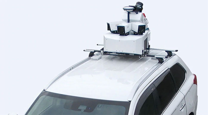
According to Mitsubishi Electric, its Mobile Mapping System uses car-mounted GNSS antennas, laser scanners and cameras to gather 3D positioning data for road assets with high-level accuracy. (Photo: Mitsubishi Electric)
Mitsubishi Electric Europe B.V. has established a High Precision Positioning Systems Division at its German branch headquarters in Ratingen, Germany.
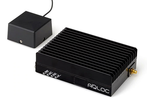
According to the company, the new division offers key technologies to German and European customers to accelerate the introduction of centimeter-level autonomous driving and safe driving assistance. These solutions include the Mobile Mapping System (MMS) and the high-precision AQLOC positioning receiver with centimeter-level accuracy for applications in road and utility vehicles, harbors and drones, as well as the agricultural sector.
AQLOC will be compatible with GNSS services and positioning data augmentation services by Sapcorda, a joint-venture by Mitsubishi Electric, Bosch, Geo++ and u-blox. MMS uses car-mounted GNSS antennas, laser scanners and cameras to gather 3D positioning data for road assets with high-level accuracy, creating the comprehensive, high-definition 3D maps needed to support autonomous driving, the company said.
The high-accuracy positioning receiver AQLOC will be compatible with GNSS services and positioning data augmentation services provided by joint venture Sapcorda. (Photo: Mitsubishi Electric)
“We are happy to add this new business area to our wide-ranging mobility solution portfolio, which already includes automotive equipment, power devices and railway systems,” said Andreas Wagner, president of the German Branch of Mitsubishi Electric Europe B.V. “The High Precision Positioning Systems Division rounds out our mobility sector and will offer German and European customers essential technologies for highly precise autonomous driving systems in a variety of scenarios.”
Mitsubishi Electric Corporation is making mobile mapping and high-precision positioning systems available in Europe, North America, Asia and Oceania. The company also will showcase the new business unit’s portfolio at Intergeo 2019, which will take place Sept. 17-19 in Stuttgart, Germany.
GPS could be used to pilot in and around lunar orbit during future Artemis missions.
A team at NASA is developing a special receiver that would be able to pick up location signals provided by the 24 to 32 operational GPS satellites. Such a capability could soon also provide navigational solutions to astronauts and ground controllers operating the Orion spacecraft, the Gateway in orbit around the Moon and lunar surface missions.
The advanced GPS receiver would be paired with precise mapping data to help astronauts track their locations in space between the Earth and the Moon, or on the lunar surface.
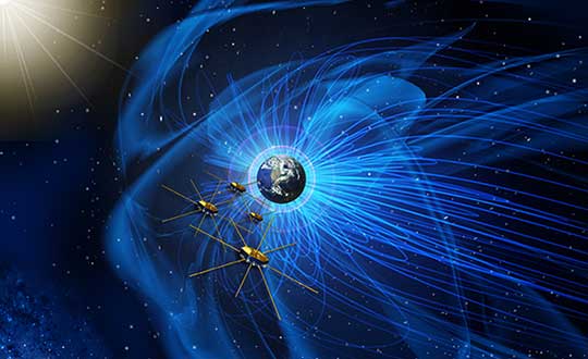
Artist’s concept of NASA’s Magnetospheric Multiscale mission consists of four identically equipped observatories that rely on Navigator GPS to maintain an exacting orbit that is at its highest point nearly halfway to the Moon. (Image: NASA)
Navigation services near the Moon have historically been provided by NASA’s communications networks. The GPS network could help ease the load on NASA’s networks, freeing up that bandwidth for other data transmission.
“What we’re trying to do is use existing infrastructure for navigational purposes, instead of building new infrastructure around the Moon,” said engineer and principal investigator Munther Hassouneh at Goddard Space Flight Center in Greenbelt, Maryland.
NASA has been working to extend GPS-based navigation to high altitudes, above the orbit of the GPS satellites, for more than a decade. The agency now believes its use at the Moon, which is about 250,000 miles from Earth, can be done.
“We’re using infrastructure that was built for surface navigation on Earth for applications beyond Earth,” said Jason Mitchell, chief technologist for Goddard’s Mission Engineering and Systems Analysis Division. “Its use for higher altitude navigation has now been firmly established with the success of missions like Magnetospheric Multiscale mission (MMS) and the Geostationary Operational Environmental Satellites (GOES). In fact, with MMS, we’re already nearly halfway to the Moon.”
Navigator GPS
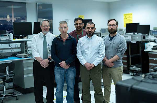
The team developing a GPS receiver for use in and around lunar orbit (from left): Jason Mitchell, Luke Winternitz, Luke Thomas, Munther Hassouneh and Sam Price. (Photo: NASA/T. Mickal)
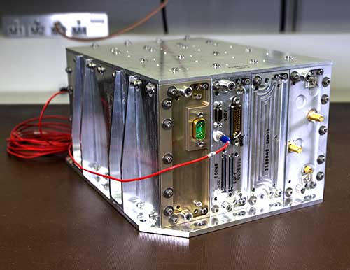
The lunar GPS receiver is based on the Goddard-developed Navigator GPS, which engineers began developing in the early 2000s specifically for NASA’s MMS mission, the first-ever mission to study how the Sun’s and Earth’s magnetic fields connect and disconnect. The goal was to build a spacecraft-based receiver and associated algorithms that could quickly acquire and track GPS radio waves even in weak-signal areas. Navigator is now considered an enabling technology for MMS.
Without Navigator GPS, the four identically equipped MMS spacecraft couldn’t fly in their tight formation in an orbit that reaches as far as 115,000 miles from Earth’s center — far above the GPS constellation and about halfway to the Moon.
“NASA has been pushing high-altitude GPS technology for years,” said Luke Winternitz, the MMS Navigator receiver system architect. “GPS around the Moon is the next frontier.”Extending the use of GPS to the Moon will require some enhancements over MMS’s onboard GPS system, including a high-gain antenna, an enhanced clock and updated electronics.
“Goddard’s IRAD (Internal Research and Development) program has positioned us to solve some of the problems associated with using GPS in and around the Moon,” Mitchell said, adding that a smaller, more robust GPS receiver could also support the navigational needs of SmallSats, including a new SmallSat platform Goddard engineers are now developing.
Building on NavCube
NavCube, which will be tested aboard the International Space Station later this year, is being used as a baseline for a lunar GPS receiver. (Photo: NASA/W. Hrybyk)
The team’s current lunar GPS receiver concept is based on NavCube, a new capability developed from the merger of MMS’s Navigator GPS and SpaceCube, a reconfigurable, very fast flight computer platform. The more powerful NavCube, developed with IRAD support, was recently launched to the International Space Station where it is expected to employ its enhanced ability to process GPS signals as part of a demonstration of X-ray communications in space.
The GPS processing power of NavCube combined with a receiver for lunar distances should provide the capabilities needed to use GPS at the Moon. Earlier this year, the team simulated the performance of the lunar GPS receiver and found promising results. By the end of this year, the team plans to complete the lunar NavCube hardware prototype and explore options for a flight demonstration.
“NASA and our partners are returning to the Moon for good,” Mitchell said. “NASA will need navigation capabilities such as this for a sustainable presence at the Moon, and we’re developing enabling technologies to make it happen.”
GPS signals extend farther than expected, meaning future space missions can reliably use GPS at extreme altitudes.
By Danny Baird
NASA’s Goddard Space Flight Center, Greenbelt, Maryland
The four Magnetospheric Multiscale (MMS) spacecraft recently broke the world record for navigating with GPS signals farther from Earth than ever before. MMS’ success indicates that NASA spacecraft may soon be able to navigate via GPS as far away as the Moon, which will prove important to the Gateway, a planned space station in lunar orbit.
After navigation maneuvers conducted this February, MMS now reaches over 116,300 miles from Earth at the highest point of its orbit, or about halfway to the Moon. At this altitude, MMS continued to receive strong enough GPS signals to determine its position, shattering previous records it set first in October 2016 and again in February 2017.
This demonstrates that GPS signals extend farther than expected and that future missions can reliably use GPS at extreme altitudes.
“At the first apogee after the maneuvers, MMS1 had 12 GPS fixes, each requiring signals from four GPS satellites,” said Trevor Williams, the MMS flight dynamics lead at NASA’s Goddard Space Flight Center in Greenbelt, Maryland. “When we began the mission, we had no idea high-altitude GPS would be such a robust capability.”
MMS’ orbit shift allows it to continue its mission to better understand the complex magnetic processes around Earth. MMS studies a fundamental process that occurs throughout the universe, called magnetic reconnection, in which magnetic fields collide and explosively release particles in all directions. Near Earth, reconnection is a key driver of space weather, the dynamic system of energy, particles and magnetic fields around Earth which can adversely impact communications networks, electrical grids and GPS navigation. Magnetic reconnection was long predicted by physicists, but not directly observed until the MMS mission.
To study Earth’s magnetosphere, the region of space dominated by the planet’s magnetic field, MMS spacecraft maintain a highly elliptical orbit around Earth. A highly elliptical orbit resembles a long oval around the globe with an extreme high point, or apogee, and low point, or perigee.
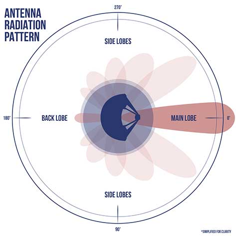
MMS’ tight formation and highly elliptical orbit require extremely accurate navigation data from GPS satellites, which are operated by the U.S. Air Force. The main GPS antenna signals enable navigation down on Earth, but precise high-altitude navigation requires both these as well as signals from the antenna’s side lobes. Side lobe signals radiate out to the side of the direction an antenna is pointing and extend past Earth.
A simplified antenna radiation pattern with different lobes of radiation extending from the antenna. (Image: NASA)
Communications engineers usually consider these side lobes wasted energy. However, the signals can be used by satellites at high altitudes on the opposite side of the globe as the GPS satellite. (Such high-altitude missions fly above GPS satellites’ orbit.) Previously, most engineers considered the upper limits of the GPS navigation in space to be an altitude of about 22,000 miles, or the altitude of satellites in geosynchronous orbit — until MMS.
Additionally, the navigation maneuvers allowed the spacecraft to gather data not available to scientists during normal operations.
“MMS usually flies in a close, tetrahedral formation [that looks like a pyramid],” said Thomas Moore, the project scientist for MMS at Goddard. “During the orbit-raising maneuvers, the spacecraft became a [straight line or] ‘string of pearls,’ which gave us unique data about the magnetosphere that may further our understanding of magnetic reconnection.”
MMS’ tight configuration and record-breaking GPS fixes would not be possible without the mission’s Navigator GPS receiver, an instrument developed at Goddard. It can detect faint GPS signals while withstanding the harsh radiation environment within the magnetosphere. NASA has made this revolutionary technology available for licensing through the Technology Transfer program, ensuring that commercial enterprise can also benefit from this innovation.
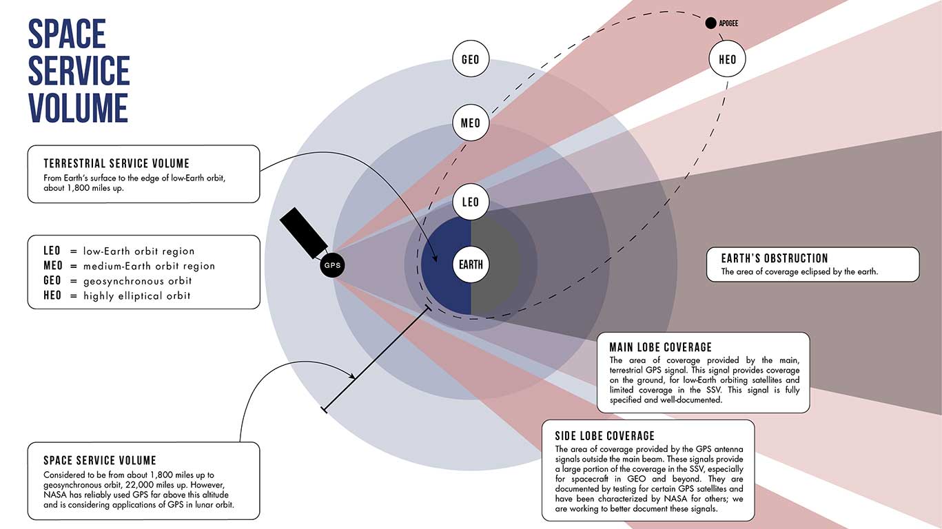
A diagram showing how GPS antenna signals can serve spacecraft at high altitudes. (Image: NASA)
In fact, NASA simulations show GNSS signals could even be used for reliable navigation in lunar orbit, just as a car uses GPS on an interstate highway. Engineers are considering using GNSS signals in the navigation architecture for the Gateway, an outpost in orbit around the Moon that will enable sustained lunar surface exploration.
“We’re working with the international community to document GNSS performance for space users, including side lobe signals,” said Joel Parker, a Goddard navigation engineer representing NASA internationally in GNSS policy. “A better understanding of GNSS capabilities will allow high-altitude missions to take advantage of the robust navigation signals they provide.”
Illustration of the four MMS spacecraft in orbit in Earth’s magnetic field. (Image: NASA).
Thanks to MMS and NASA’s navigation engineers, the sky is no longer the limit.
NASA’s Science Mission Directorate provides strategic oversight to MMS. Goddard’s Explorers and Heliophysics Projects Division manages the mission. The four MMS spacecraft launched on March 13, 2015, from NASA’s Kennedy Space Center in Cape Canaveral, Florida, on board an Atlas V launch vehicle.
NASA’s Space Communications and Navigation (SCaN) program office oversees the agency’s work in navigation policy related to GNSS. NASA, consulting the United Nations International Committee on GNSS (ICG), collaborates with other U.S. agencies and the six international GNSS providers to define GNSS requirements and develop additional capabilities. The team of SCaN navigation specialists charged with aiding the ICG are based out of the Exploration and Space Communications projects division at Goddard.
Telephonics Corporation’s subsidiary, Systems Engineering Group (SEG), will demonstrate autonomous UAV control and PULSEbox this month during the Annual Naval Technology Exercise (ANTX), Dahlgren (Virginia) Division event.
ANTX-Dahlgren, being held Sept. 13-14, is a two-day event providing a low-risk environment to evaluate technological innovations at the research and development level before technologies become militarized and integrated at the operational level.
The autonomous UAV control demonstration will include a system manager in a UAV control ConOps scenario. System Manager is a model-based expert system of systems, which can plan, schedule and initiate ConOps processes to provide round the clock automation in the Flight Dynamics Operations Area (FDOA) on NASA’s Magnetospheric Multiscale (MMS) mission. This enables NASA to minimize human involvement in controlling satellite maneuvers along with optimizing data downloads.
PULSEbox offers a high fidelity, real-time, RF threat scene generator that integrates SEG’s threat models with optimized hardware. The system will create advanced test ecosystems by providing real-world target simulated threat states and related radar representations in laboratory settings, leading to improved testing of interoperable elements before live-sea testing events of air-breathing and ballistic missile threats, the company said.
“Both the autonomous UAV control and PULSEbox technologies align with the U.S. Navy’s requirements for more autonomous systems with limited human control requirements and more realistic training, simulation and modeling environments,” said Michael Anderson, Telephonics vice president and SEG general manager.
The four MMS spacecraft host the highest ever operational GPS receivers in space. (artist’s rendition, credit: NASA)
Editor’s Note: See additional coverage of the MMS mission here.
September Marks Start of Magnetosphere Mission, but Navigators Already Perform
A NASA mission to explore magnetic reconnection also made GPS history this spring. The Magnetospheric Multiscale (MMS) mission, led by NASA’s Goddard Space Flight Center in Greenbelt, Md., is flying four identically equipped spacecraft in a tight formation to take measurements 100 times faster than any previous space mission.
Each of the four spinning MMS spacecraft — roughly the size of a ballpark once eight booms deploy — is equipped with 25 sensors and other components provided by more than 40 partner institutions in the U.S., Europe and Japan. One key component is a GPS receiver dubbed Navigator.
Magnetic reconnection is a fundamental, yet poorly understood process.While reconnection occurs throughout the universe when magnetic field lines within plasma connect and disconnect, it can impact our technological society, since it drives virtually all space weather events that can disrupt low-Earth-orbiting spacecraft and lead to GPS, communications and power blackouts on Earth.
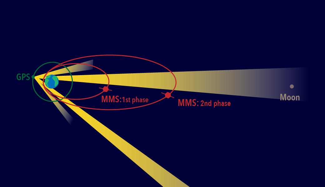
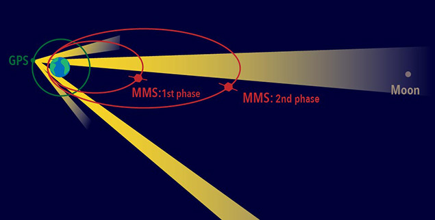
During the mission’s first phase, which begins in September, the spacecraft will travel through reconnection sites on the sun-side of Earth, where the orbit extends out toward the sun to around 47,500 miles. One year later, ground controllers will move the spacecraft to Earth’s night-side or magnetotail where the magnetic fields also reconnect — an orbit that extends away from Earth to almost 99,000 miles, nearly halfway to the moon.
However, science operations can’t begin before the four move into a highly elliptical orbit and assume their pyramid-shape formation that places the spinning spacecraft just 6.2 miles apart. It required a breakthrough to accomplish such an exacting formation, and the Goddard-developed Navigator GPS provided the solution.
Begun in the early 2000s as an enabling technology for MMS-type missions, the Navigator receiver and associated algorithms can quickly acquire and track GPS radiowaves even in weak-signal areas well above GPS’s 30-plus-satellite constellation positioned about 12,550 miles above Earth. In addition to continuously tracking weak signals, the Navigator also must operate as the spacecraft spin at three revolutions per minute. As a result, each MMS satellite is equipped with two Navigator receivers (primary and redundant), with four antennas placed around the perimeter of each, assuring continuous contact with the tracked GPS satellites
“Spinning adds a whole new dimension to trying to figure out where you are,” said Ken McCaughey, MMS GPS Navigator Product Development Lead at Goddard. “As the spacecraft rotates we have an algorithm running that allows us to hand off from one antenna to the next without losing the signal.”
Robust Receivers. To the satisfaction of the technology’s architect, Goddard technologist Luke Winternitz, the receivers have proven very robust. Shortly after the GPS receivers were powered on after the launch, Navigator became, at more than 43,500 miles above Earth’s surface, the highest ever operational GPS receiver in space. “We’re tracking up to 12 GPS satellites at maximum altitude and track on average about nine,” Winternitz said. “We’re really excited about their performance so far.”
Even if the receiver were to lose all GPS signals for part of the orbit, Navigator is specifically designed to handle such dropouts. By gathering as many observations as possible, integrated software called GEONS — Goddard Enhanced Onboard Navigation System — can still compute the orbit by incorporating additional information including drag force, gravity, and solar radiation pressure.
The red ellipses show the MMS orbit paths during the first and second phases of the mission. Each spacecraft uses GPS signals — which come from satellites situated along the green circle shown surrounding Earth — from the far side of Earth to track its position. (Credit: NASA/MMS)
This system will be even more important during the second phase of the MMS mission when the orbit will double in size and travel all the way out to 95,000 miles from Earth.
“It’s going to be very interesting to see how far out MMS can still receive signals,” said Mission Deputy Project Manager Brent Robertson. “But Navigator has already far exceeded expectations.”
Almost all activities associated with operating the mission depend on where the satellites will be positioned a few days hence. That includes everything from determining the best time to downlink telemetry and scientific data to calculating when ground controllers would command the firing of the satellites’ onboard thrusters, which move and help maintain their orbital formation — an exercise that will happen at least once every couple weeks.
“I think there’s a good chance we’ll end up being able to use GPS and save us some of the expense of using ground observations,” Robertson said.
While Navigator technology and GPS receivers were previously flown for testing and to help navigate a low-earth-orbit mission, this is the first time that the complete Navigator package has been used to actively navigate a high-altitude mission. Now that the team knows it works so well, Navigator can be used for other missions that travel in similar high orbits.
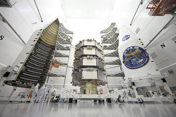
The four MMS observatories are processed for launch in a clean room at the Astrotech Space Operations facility in Titusville, Fla. The MMS mission launched March 12, 2015. (Credit: Ben Smegelsky/NASA)
Navigator Highlights
At the highest point of the MMS orbit, at more than 43,500 mile above the surface of the earth, Navigator set a record for the highest ever reception of signals and onboard navigation solutions by an operational GPS receiver in space.
At the lowest point of the MMS orbit, Navigator set a record as the fastest operational GPS receiver in space, at velocities over 22,000 miles per hour.
At the farthest point in its orbit, some 43,500 miles away from Earth, Navigator can determine the position of each spacecraft with an uncertainty of better than 50 feet.
The red ellipses show the MMS orbit paths during the first and second phases of the mission. Each spacecraft uses GPS signals — which come from satellites situated along the green circle shown surrounding Earth — from the far side of Earth to track its position. (Credit: NASA/MMS)
Editor’s Note: See more about the MMS mission in our August issue. The article is also posted here.
News courtesy of NASA
After years of hard work building a spacecraft, a mission team anxiously awaits after a launch — will the instruments they’ve crafted all work as well as planned? This is all the more true when flying new hardware, such as the onboard navigation tool on the four spacecraft that make up the Magnetospheric Multiscale, or MMS, mission, which launched on March 12. This navigation system had never before flown on a spacecraft with an orbit traveling so far from Earth — but if it worked, it would provide the precision navigation needed for MMS.
And the results are now in: Not only has the MMS Navigator system exceeded all of the team’s expectations, it has set the record for the highest GPS use in space.
At the highest point of the MMS orbit, at more than 43,500 mile above the surface of the earth, Navigator set a record for the highest-ever reception of signals and onboard navigation solutions by an operational GPS receiver in space.
At the lowest point of the MMS orbit, Navigator set a record as the fastest operational GPS receiver in space, at velocities over 22,000 miles per hour.
A precise tracking system is crucial for MMS, which requires extremely sensitive position and orbit calculations. The four spacecraft must fly in a tight pyramid formation to gather science data as they move through Earth’s magnetic environment. The formation is required to obtain three-dimensional observations of a phenomenon called magnetic reconnection that occurs when magnetic fields from the sun connect and disconnect with magnetic fields of Earth, which can allow energy and solar material to funnel into near-Earth space. With its instrument booms deployed, each spacecraft is the size of a baseball field — while flying as close as six miles from each other.
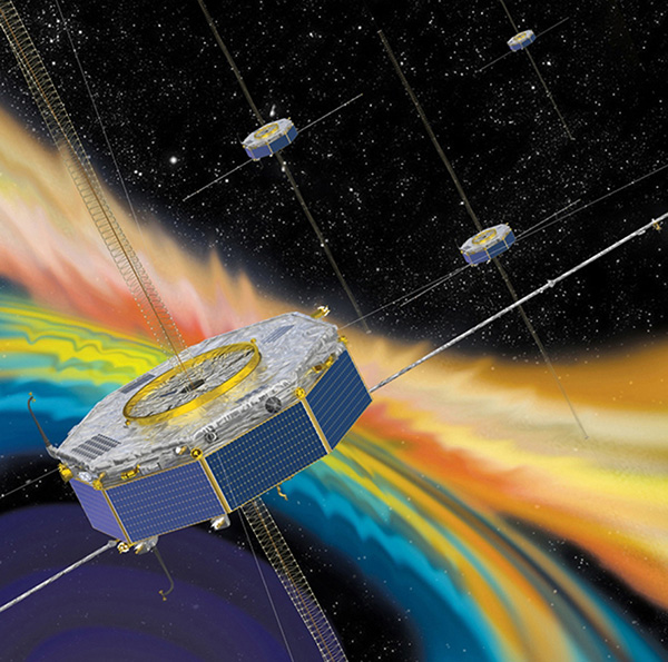
Artist’s concept of the MMS (courtesy of NASA).
“Demonstration airplanes like the U.S. Navy’s Blue Angels fly in closer formations, but those planes are also much, much smaller and the pilots are always controlling the movements,” said Brent Robertson, deputy project manager for MMS at NASA Goddard Space Flight Center in Greenbelt, Md. “We have four giant spacecraft each with its own unique orbit that we make maneuvers on about every two weeks. It’s quite challenging to control this formation.”
Tracking spacecraft can be done by radar stations from the ground, but it’s much more expensive and takes longer than an inflight system. However, using GPS as is typically done on Earth by such things as cars, boats and smartphones isn’t nearly as simple for something like MMS. For one thing, the bulk of its highly-elliptical orbit occurs above where the GPS transmitters orbit. So MMS must have specialized, extremely sensitive receivers to capture GPS signals transmitted from the far side of Earth. In addition the MMS spacecraft spin; each one makes three revolutions per minute.
“Spinning adds a whole new dimension to trying to figure out where you are,” said Ken McCaughey, MMS GPS Navigator Product Development Lead at Goddard. “We have four GPS antennas on each spacecraft. As the spacecraft rotates we have an algorithm running that allows us to hand off from one antenna to the next without losing the signal.”
In the first month after launch, the MMS team began turning on and testing each instrument and deploying booms and antennas. During this time, the team compared the Navigator system with ground tracking systems and found it to be even more accurate than expected. At the farthest point in its orbit, some 43,500 miles away from Earth, Navigator can determine the position of each spacecraft with an uncertainty of better than 50 feet.
What’s more, the receivers on MMS have turned out to be strong enough that they consistently track transmissions from eight to 12 GPS satellites — excellent performance when compared to pre-flight predictions that there might be frequent drop outs during each orbit.
Even if the receiver were to lose all GPS signals for part of the orbit, Navigator is specifically designed to handle such dropouts. By gathering as many observations as possible, integrated software called GEONS — for Goddard Enhanced Onboard Navigation System — can still compute the orbit by incorporating additional information including drag force, gravity, and solar radiation pressure.
This system will be even more important during the second phase of the MMS mission when the orbit will double in size and travel all the way out to 95,000 miles from Earth.
“It’s going to be very interesting to see how far out MMS can still receive signals,” said Robertson. “But Navigator has already far exceeded expectations. I think there’s a good chance we’ll end up being able to use GPS and save us some of the expense of using ground observations.”
While Navigator technology and GPS receivers were previously flown for testing and to help navigate a low-earth-orbit mission, this is the first time that the complete Navigator package has been used to actively navigate a high-altitude mission. Now that the team knows it works so well, Navigator can be used for other missions that travel in similar high orbits.