I keep waiting for the cryptic phone call or emphatic email from Trimble that says, “You have had our evaluation units for over four months — when can we expect to see a review and when will you be returning our equipment?” Fortunately, Trimble is very understanding and would never make such a call or send such an email, I hope. The truth is Trimble sent me a T41 and Yuma 2 for review back when it was still snowing in the Rocky Mountains and I am still evaluating the units. You see that’s the rub with excellent equipment — it is a pleasure to review GPS equipment that exceeds all expectations, and frankly, it is difficult to send it back because there is always one more project, one more test or one more application that needs to be run. Fortunately the Trimble PNT equipment (position, navigation and timing) has never been found wanting. So here finally is the T41 review that so many of you have requested.
First, however, for those of you who are of a similar age to yours truly — and let’s just say it hopefully relates to a certain level of maturity and in my case familiarity with GPS since 1978 — I just can’t see the designation T41 without thinking of: (1) a basic USAF pilot and navigation training aircraft once flown at Mather Air Force Base in California and one I still see every day at the Unites States Air Force Academy and flying over my home on a regular basis, and (2) the first successful commercial GPS unit built by my think-tank colleague Philip Ward at Texas Instruments, designated the T1-4100. I have no idea if Trimble was aware of these associations when naming conventions were considered for the T41, but for many of us seniors the associations certainly exist. That is not a bad thing — it probably even extends to goodwill in a business sense, if you understand that jargon. But, as usual, I digress!
BLUF (Bottom Line Up Front)
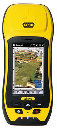
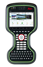
As loyal readers are aware, I never give a product a bad review. That is not to say I do not receive my share of simply “bad” GPS equipment to review. I just refuse to take the time to pen a bad review — my philosophy being, why should I take the time to write and why should you take the time to read about something you can’t or won’t use? There are enough “good,” even exceptional, GPS devices out there today that deserve to be written about — so let’s just skip the bad ones and save us all some grief and deflated expectations. So the very fact that I am writing about the Trimble T41 means that it has passed all my tests for ruggedness and usefulness. In fact (I checked the figures with my review logs for the past seven years), for every 20 GPS devices I receive, I only review one on average. This month it is the Trimble JunoT41/5 X-Model with gray pin striping and an IP68 ruggedness rating, and you will see why that level of model detail is important shortly.
Who Matters as Much as What
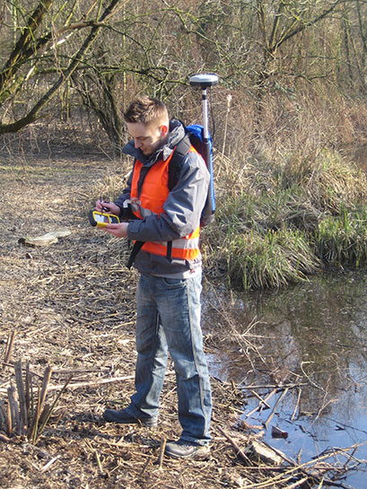
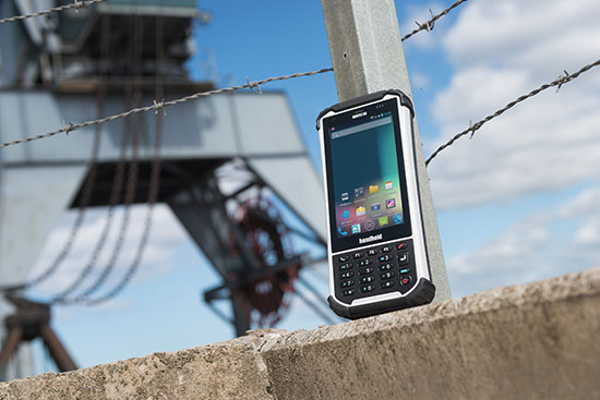
Before I get into the technical aspects of the T41, let’s consider for a moment who would want to use this unit. Without a doubt, it is perfect for warfighters and first responders or I probably would not write about it, but it is also perfect for anyone that needs a rugged handheld computer with embedded GPS running either the Windows or Android operating system (OS). The touchscreen display covers about the same real estate as the new iPhone 5 but the T41 is slightly larger, heavier, thicker and, it almost goes without saying, incredibly rugged. I guess that is why I have received several letters from T41 users that use it on horseback.
Now, while I perceive the equine GPS market to be a niche market, another one of my think-tank colleague, the Honorable Jim Geringer, who ran the great state of Wyoming from 1995 to 2003, has mentioned several times in passing, and I mistakenly thought jokingly, ranchers using GPS on horseback. Now that I think about it and read some of my email from Colorado, Wyoming, and Montana ranchers, it makes sense. Think about navigating thousands of acres of ranch land that in some cases all looks the same, looking for lost cattle or damaged fences. Think about wanting to mark the spot where cattle or damaged fences were found and then being able to quickly communicate that information to someone who could help, and then just as quickly navigate back to civilization, even in a blizzard. The fact is my correspondence from several ranchers tells me that GPS has become indispensible – and not just any GPS, but a reliable, accurate and rugged GPS that has a long battery life, comes with a built-in camera, and the option for a solar charger, and of course has embedded communication capabilities. Sounds a great deal like the T41 – I think you will agree.
Basics and Specifications
The Juno T41/5 approximates a slightly larger iPhone 5 in size, but one with an extremely rugged case. The case makes it bigger and heavier, but at the same time much more useable in all weather conditions, to include snow, ice, water, dust, all of which I personally tested for, and I suspect it will survive being dropped in horse manure, although I will admit this is one test that I have not personally performed. I will graciously defer to my equine mounted readers when it comes to performing this particular test. Can you say rubber gloves, Purell Hand Sanitizer and Fabreze?
Trimble Juno T41/5 Specifications
FEATURES
- Processor: 800 MHz or 1 GHz, Texas Instruments DM3730
- RAM: 256 MB or 512 MB
- Flash Storage: 8 GB or 16 GB
- 4.3” WVGA sunlight-readable Gorilla® Glass display
- Light sensor to auto-adjust display brightness
- Capacitive multi-touch interface
- Integrated 3.75G cellular data, text and voice capability
- 8 megapixel camera with geo-tagging and dual LED flash
- Bluetooth 2.1 with Enhanced Data Rate
- Wi-Fi (802.11 b/g/n)
- GPS Receiver, 2-4 meter accuracy (WAAS/SBAS Capable)
- MCX port for optional External GPS Antenna
- Electronic Compass
- Accelerometer
- Robust Custom Port with USB 2.0 Full Speed Protocol
- Conversion Cables available for 9-pin Serial or USB host
- Micro SD memory card slot (supports SDHC up to 32 GB)
- Integrated speaker and microphone
- 3.5 mm Headset Jack with Audio Capability
OPERATING SYSTEMS
- Windows Embedded Handheld 6.5
- Android 4.1 – which is faster, has better battery usage, more secure and with better developer specifications than the older version 2.3.4
- Language Support: Chinese (Simplified), English, French, German, Italian, Japanese, Korean, Portuguese, Russian or Spanish
Windows Embedded Handheld 6.5
Standard Software:
- Trimble SatViewer (GPS interface application)
- Trimble CellStart (WWAN configuration application)
- Microsoft Office Mobile 2010 (Word Mobile, Excel Mobile, PowerPoint Mobile, Outlook Mobile)
- Internet Explorer Mobile 6
- Microsoft My Phone with SMS Text Messaging
- Camera Control Application
- Flashlight Control Mode Application
- Calculator
- Calendar
- Microsoft Pictures and Videos
- Windows Media Player
- Windows Live Messenger
- Microsoft Task Manager and Notes
- Adobe Reader LE 2.5
Android 4.1 Advanced Software:
- Trimble Outdoors Navigator
- Email
- Phone and SMS Text Messaging
- Picture and Video Gallery
- Multimedia Player
- Web Browser
- Camera Control Application
- Flashlight Mode Control Application
Application Developer Support:
- Software Developer Kit with Documentation for WEH 6.5
- Software Developer Kit with Documentation for Android 4.1
STANDARD ACCESSORIES
- International AC Charging Kit
- T412 USB Cable
- Wrist Strap
- Ultra Clear Screen Protectors (qty-2) Kit
- Quick Start Kit
OPTIONAL ACCESSORIES
- 9-pin Serial Adapter
- USB Host Adapter
- Capacitive Stylus with Tether
- External Battery Pack
- Port Cover
- Ultra Clear Screen Protectors (qty-10) Kit
- Anti-reflective Screen Protectors (qty-2) Kit
- Vehicle Charging Kit
- Capacitive Touch Screen Gloves
- Trimble Headset
- External GPS Antenna
ENVIRONMENTAL SPECIFICATIONS
Water: Survives immersion at 3.3 feet (1 meter) for two hours (gray models), IEC-60529 IPx8. Survives driving rain & water spray (yellow models), IEC-60529 IPx5, water jet 12.5 mm diam @ 2.5-3 m.
Dust: Protected against dust, IEC-60529 IP6x, dust chamber with under-pressure
Drops: Survives multiple drops of 4 ft. (1.22 m), MIL-STD-810G, Method 516.6, Procedure IV, Transit Drop
Operating Temperature: -22 ºF to 144 ºF (-30 C to 60 C), MIL-STD-810G, Method 502.5, Procedure I, II, III (Low Temp Operating -30 C); Method 501.5, Procedure I & II (High Temp Operating 60 C)
Storage Temperature: -40 ºF to 158 ºF (-40 C to 70 C), MIL-STD-810G, Method 502.5, Procedure I, II, III (Low Temp Storage -40 C); Method 501.5, Procedure I & II (High Temp Storage 70 C)
Temperature Shock: Cycles between -22 ºF and 144 ºF (-30 C and 60 C), MIL-STD-810G, Method 503.5, Procedure I-C
Humidity: 90% relative humidity with temperatures between 22 ºF and 144 ºF (30 C and 60 C), MIL-STD- 810G, Method 507.5, Procedure II
Altitude: 15,000 ft (4,572 m) at 73 °F (23 C) to 40,000 ft (12,192 m) at -22 °F (-30 C), MIL-STD-810G, Method 500.5, Procedure I, II & III
Vibration: General minimum integrity and loose cargo tests, MIL-STD-810G, Method 514.6, Procedure I & II, Category 5
Solar Exposure: Survives prolonged UVB exposure, MIL-STD- 810G, Method 505.5, Procedure II
Chemical Exposure: Resistant to mild alkaline and acid cleaning solutions, fuel hydrocarbons, alcohols and common vehicle and factory machine lubricants.
PHYSICAL
Size. . . . . . . . . .6.1 in . 3.2 in . .9 in (15.5 cm x 8.2 cm x 2.5 cm)
Weight. . . . . . . . . . . . . . . . . . . . 13.5 oz (.4 kg), including battery
Color . . . . . . . . . . . . . . . . . . .Black with Yellow or Black with Gray (Color does make a difference; see Product Models below.)
ELECTRICAL
Processor: 800 MHz or 1 GHz, Texas Instruments DM3730
Memory: 256 MB or 512 MB
Storage: 8 GB or 16 GB, non-volatile
Expansion: micro SD card slot, SIM card slot
Display: 4.3 in (10.9 cm), 480 x 800 pixel, WVGA TFT
Battery: 3.7 V, 3.3 Ah, 12.2 Wh, Lithium-ion polymer
I/O: 3.5mm audio jack; Custom Port that supports USB 2.0 Host, USB Client, 9-pin Serial and 5.6 V (5.0 V to 5.9 V) DC input power
GPS Receiver: 2-4 m accuracy with WAAS/SBAS correction; MCX port for optional external antenna
Radios: Bluetooth 2.1 +EDR; Wi-Fi 802.11 b/g/n
WWAN radios: UMTS / HSPA+, GSM / GPRS/ EDGE; UMTS Bands (WCDMA/FDD): 800, 850, 1900, AWS and 2100 MHz; GSM Bands: 850, 900, 1800, 1900 MHz
CERTIFICATIONS
FCC, CE, R&TTE, IC (Canada), C-tick, GCF compliant, RoHS compliant, Section 508 compliant, PTCRB, SAR, AT&T network compatible, Wi-Fi Alliance certified, CCX, USB 2.0 Full Speed, MIL-STD-810G, IP65/IP68, MIL-STD-461E.
PRODUCT MODELS
|
Color
|
IP Rating
|
Processor |
RAM |
Storage |
WWAN
|
GPS
|
Camera
|
|
M
|
Gray
|
IP68
|
800 MHz |
256 MB
|
8 GB
|
–
|
2-4 m
|
–
|
|
C
|
Yellow
|
IP65
|
800 MHz
|
256 MB
|
8 GB
|
–
|
2-4 m
|
8 MP
|
|
C
|
Gray
|
IP68
|
800 MHz
|
256 MB
|
8 GB
|
–
|
2-4 m
|
8 MP
|
|
X
|
Yellow
|
IP65
|
1 GHz |
512 MB
|
16 GB
|
3.75G
|
2-4 m
|
8 MP
|
| X |
Gray
|
IP68
|
1 GHz |
512 MB
|
16 GB
|
3.75G
|
2-4 m
|
8 MP
|
|
|
|
|
|
|
|
|
|
|
|
|
|
|
|
|
The M model features a GPS receiver, 800-MHz processor, 256 MB RAM, 8-GB storage and is available in gray with IP68 rating. The C model adds an 8-megapixel camera with dual LED flash, Bluetooth and Wi-Fi to the M model feature set and is available in yellow with IP65 rating or gray with IP68 rating. The X model adds penta-band GSM cellular phone and data capability to the features of the C model, has a 1 GHz processor, 512 MB RAM and 16 GB storage and is available in yellow with IP65 rating or gray with IP68 rating.
Key Features
WVGA Sunlight-Readable Gorilla Glass Display. I found the 4.3-inch color display to be readable in all lighting conditions. From very low light to bright sunlight, even sun reflecting off snow, which I have found to be the most difficult condition. The Gorilla glass is aptly named, as its unique composition allows for a deep layer of high compressive stress, which is created through an ion-exchange process during the manufacturing process by Corning Glass. This compression acts as a sort of “armor,” making the glass exceptionally tough and durable, and yet the display is crystal clear.
Multi-Touch User Interface with Capacitive Stylus Compatibility. Now, I am well aware that one of my heroes, Steve Jobs, once said that “…if you are required to use a stylus on a computer, you have lost your advantage.” However, there are just simply times, especially with GIS (geographical information systems) and map displays, when something smaller and more accurate than the end of your little finger is called for, and on the T41 you have your choice. The display also functions with a capacitive glove, which you can purchase from Trimble as an option or from many other vendors. The bottom line is the 4.3-inch high resolution screen is very clear, and as Trimble says “…the multi-touch support allows complex selections and controlled zoom to optimize the user experience with maps and detailed information.”
3.75G Cellular Data, Text and Voice Capability. A GPS or PNT device today without communication capabilities is a device that simply cannot compete, in the marketplace or in any situational awareness competition/situation you would care to name. Communication capabilities allow any PNT device to make use of PNT augmentation available over the Internet and through private networks such as the Trimble VRS or Virtual Reference Station and the John Deere StarFire network. Indeed, the Trimble VRS network enables precise, real-time GNSS positioning through the distribution of correction data. The global networks provide a highly reliable method for surveyors, warfighters, and other geospatial and PNT professionals to work faster and achieve accurate GNSS results, as precise as three centimeters in real time, for a variety of positioning applications including geodetic and cadastral surveying, road and bridge construction, mapping, agriculture, earthquake and tectonic plate movement monitoring, warfighter applications, and scientific research, as well as other high-accuracy positioning applications. Trimble’s VRS networks use RTK (real-time kinematic) solutions that, when combined with the Trimble RTKNet software, provide high-accuracy RTK GNSS positioning for wide areas. A VRS network improves productivity while reducing complexity and the global footprint for warfighters, by eliminating the need to set up a base station.
A VRS network is made up of the latest in GNSS hardware, modeling, and networking software, plus communications interfacing. Once set up, RTK roving receivers in the field or AOR (Area of Responsibility) have access to real-time network modeled corrections. In the field you also have the reassurance of the built-in integrity monitoring system that warns if there are any problems with the data.
Today Trimble’s VRS networks are considered an integral tool for providing fast, high-precision, wide area positioning for warfighters and first responders in countries around the world. The Trimble VRS and John Deere RTK StarFire systems also give the device, especially in the case of a warfighter, additional situational awareness, along with the capability to act not only as a receiver, but as a networked device, a sensor, and a monitoring station. The T41 handheld has voice, SMS text, and 3.75G cellular data transfer capabilities on GSM cellular networks worldwide. You can upload and download data from the cloud using Wi-Fi or WWAN connections. The 8-megapixel camera can be set to automatically include time and location metadata from the GPS receiver. The T41 not only has the ability to increase the individual warfighter’s situational awareness but to increase the SA for all users on the network and in the AOR as well.
Bluetooth 2.1 + EDR and Wi-Fi b/g/n. You may well wonder why I have listed this as a separate feature when it could just be included under communications. I have listed it separately because of the Army’s laudable Puck and Hub endeavors. (See my GPS World May column for the detailed briefing). Without going into too much detail, the Puck and Hub are sorely needed PNT receivers with augmentation capabilities to include Wi-Fi, inertial, and CSAC (Chip Scale Atomic Clocks) that are hopefully multi-GNSS signal-capable. The only feature both devices lack is a suitable and rugged display mechanism. This is where the Bluetooth, Wi-Fi and Android capabilities of the T41 come into play. The Army seems, for the time being, to have mysteriously settled on the Android OS as a basic capability and building block that, when combined with Bluetooth and Wi-Fi, make the T41 the perfect display device. I cannot say much more in this venue, but take my word for it when I say I have never tested another purpose-built rugged PNT-capable device more suitable for the Army’s Puck and Hub applications. Suffice it to say that Software Developer Kits (SDK) for both Android and Windows OS enable custom application software to easily interface, wired and wirelessly, with the many built-in sensors, radios, and data ports on the T41. For instance, a secured Bluetooth signal embodied in the 2.1 and EDR (Enhanced Data Rate) specifications would allow users to transfer data to and from the Puck or Hub while maintaining voice or SMS connectivity with other networked users and commanders, who are able to make faster and hopefully better decisions based on real-time information.
GPS Receiver with 2-4 Meter Accuracy. At its core, the T41 is indeed a GPS receiver that is SBAS (Satellite Based Augmentation System) capable, which means it can take advantage of the augmentation and integrity signals from the U.S. WAAS (Wide Area Augmentation System) and the European EGNOS (European Geostationary Navigation Overlay Service). However, when combined with the device’s prodigious communications capabilities — Wi-Fi, Bluetooth, and the Internet — the device becomes a truly multi-GNSS capable receiver with ports that can, hopefully in the future, accommodate such devices as the CGM (common GPS module) that includes SAASM (Selective Availability Anti-Spoofing Module) and M-Code capabilities. It also includes the Trimble and John Deere networks as mentioned earlier, and this gives the device the capability of 3-centimeter RTK accuracy. Think about it: I have never heard a warfighter say, “I need a less capable, less versatile and less accurate device.”
Accelerometer and Electronic Compass. Ask a warfighter if he needs an accelerometer, and he might scratch his head, but ask about an electronic compass and the answer is an emphatic yes. Think map reading, orienteering, and getting out of Dodge fast. Think urban canyons or vast, featureless deserts where a warfighter has no intrinsic idea which way is which. That’s when you need a compass, but an accelerometer —as any iPhone aficionado will tell you — is almost indispensible. The accelerometer detects physical movement and is primarily used for motion sensing and tilt controls. It also detects vibration and acceleration, allowing the T41 to detect the distance and speed it has moved in three-dimensional space. Combined with the right software, it may prove to be a key component of determining position, distance, and speed in challenged environments.
Nine-Pin Serial and Power Port. The last feature I will highlight about the T41 is the nine-pin serial data and power port. The serial cable is secured to the T41 for power and data by a secure data/power cable that is attached with thumb screws on one end and by a USB connector on the other. In rugged environments it provides both a secure means of power from multiple sources and a universal data connector, neither of which are going to work their way loose and leave you with a dead battery or no data. It is almost legacy in design, but innovative in that one multi-function cable provides power and serial data inputs. I used it for both power and data and it worked flawlessly — plus I never had to worry about a loose or lost connection.
Bottom Line
The bottom line is I highly recommend the Trimble Juno T41 in any of its configurations, which are many. It is rugged to a fault, sturdy and has one of the best displays I have ever seen. I reviewed the Windows OS version but have no doubt the Android OS works equally well, and that is, after all, the OS on which the Army is pinning its future plans and hopes for PNT devices. However, as I said in the beginning, I do not want to limit this device to the warfighter. It certainly fills the bill there, but it also competes well and indeed exceeds the capabilities of many similar devices that lack the built-in ruggedness and the Trimble reputation for consistently producing superior devices. This review is already 3,500 words, and I could easily write another 5,000 words, but hopefully you get the point. If you need a very rugged phone, a computer in a handheld form factor with embedded 3-cm level GPS capabilities that sports a crystal clear display and is a device with huge growth potential, then the T41 is exactly what you need. I know of nothing better in the marketplace today. It is really going to be tough to send this one back.
Now I wonder just how long I can keep it before that dreaded emphatic phone call or cryptic email…
Until next time, happy navigating and give the T41 a test-drive.
Editor’s note: Readers interested in owning a Juno T41 can enter a GPS World drawing by filling out our State of the Industry Survey.
 TerraGo Edge version 3.7, now available, includes new intelligent, responsive forms, as well as GPS and GIS enhancements designed to dramatically improve the speed, quality and efficiency of asset inspections, land surveys and any location-based data-collection project.