Tag: mobile phones

  • Keysight combines GNSS and 5G to accelerate assisted-Galileo LBS

    Keysight combines GNSS and 5G to accelerate assisted-Galileo LBS

    Tbe company has received Global Certification Forum validation of 5G LBS Assisted-Galileo test case

    Keysight Technologies Inc. has gained Global Certification Forum (GCF) validation of a 5G location-based services (LBS) assisted-Galileo (A-Galileo) test case by combining 5G new radio (NR) and GNSS technology.

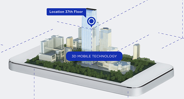
    The achievement will accelerate implementation of LBS in smartphones by enabling mobile phone vendors to verify that designs comply to the latest 3GPP specifications that support accurate location positioning in a wide range of sectors.

    Sectors include healthcare, road and aerial transportation, emergency and rescue services, public safety, and homeland security.  Highly precise positioning services also enable mobile operators to deliver personalized services supporting entertainment, hospitality and retail applications.

    LBS leverages different technologies, including GNSS, beamforming and round-trip time to geographically locate a user. LBS test cases allow users to verify sensitivity, accuracy and dynamic range in mobile phones that leverage GNSS constellations to identify precise geographic location.

    S8705A RF/RRM DVT and Conformance Toolset. (Photo: Keysight)
    S8705A RF/RRM DVT and Conformance Toolset. (Photo: Keysight)

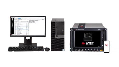
    GCF conformance agreement group meeting #72, held Oct. 21, confirmed the validation of the first 5G LBS A-Galileo test case, which was supported by Keysight’s S8705A RF/RRM DVT and Conformance Toolset. The toolset provides access to a wide range of radio frequency, radio resource management, and development validation test cases used to verify 5G NR designs in both non-standalone and standalone deployment modes.

    The S8705A toolset uses the E7515B UXM 5G Wireless Test Platform, a compact signaling test platform with multi-format stack support, rich processing power and abundant RF resources for emulating various mobility scenarios in a 5G network as well as a recommended GNSS emulator to deliver the LBS test case.

  • Polaris Wireless provides E911 z-axis for Schok flip phones

    Polaris Wireless provides E911 z-axis for Schok flip phones

    Image: Polaris
    Image: Polaris

    Phone users can now be located by emergency responders within one floor level inside multi-story buildings 

    Polaris Wireless, an innovator of high-accuracy software-based wireless location solutions, announces the company’s Z-axis location solution is commercially available nationwide.

    The technology — demonstrated to meet the 3-meter vertical location accuracy requirement of the Federal Communications Commission (FCC) — is integrated into Schok Gear’s newly released flip phones.

    Schok’s flip phones are typically used by consumers looking for a simple, yet powerful flip phone, that can now be accurately located in emergencies. Adding indoor and vertical location to these devices enables first responders to locate all wireless 911 callers with floor-level accuracy in multi-story buildings.

    “This is a major milestone for the 911 industry to deliver FCC-compliant Z-axis emergency location technology for users of feature phones” said Manlio Allegra, CEO and Founder of Polaris Wireless. “Working with Schok and their partners has been straightforward and it’s exciting to see for the first time the complete Z-axis solution commercially available in a flip phone.”

    “The Polaris Wireless location software was seamlessly integrated with our existing location and chipset vendors” said Samuel Gutiérrez, chairman and CEO, Schok, LLC. “Our Schok flip feature phone passed Tier I carrier acceptance testing, which for the first time included Z-axis location. Now our customers can be assured their accurate vertical location will enable first responders to find them faster in an emergency.”

    The vertical component of wireless location is critical in today’s environment when most 911 calls are placed by mobile phones and increasingly indoors, where location determination is particularly challenging. Accurate indoor wireless location is a game-changer for first responders to quickly get to where they are needed, regardless of the phone being used by callers. The Polaris Wireless Z-axis service is available seamlessly nationwide for public safety and commercial deployments.

  • Location systems provider Syntony GNSS joins TCCA

    Location systems provider Syntony GNSS joins TCCA

    Syntony GNSS has joined TCCA, a global representative body for the critical communications ecosystem.

    With offices in France, the United States and Canada, Syntony designs and manufactures GNSS products, including receivers and simulators dedicated to mission-critical applications, transportation, aerospace and defense.

    According to an industry report, the global GNSS simulators market size is set to grow from USD 106 million in 2020 to USD 165 million by 2025, at a CAGR of 9.3% during the forecast period. Various factors such as rapid penetration of consumer IoT, the contribution of 5G in enabling ubiquitous connectivity, and increasing use of wearable devices utilizing location information are expected to drive the adoption of the GNSS simulators hardware, software and services.

    Syntony GNSS manufactures SubWAVE, a solution that enables GPS to work underground and makes possible critical safety services. SubWAVE enables emergency call location in underground tunnels and stations from any smartphone. It also provides the location of any first responder using a compatible P25 or TETRA receiver.

    A Syntony team member in a Swedish road tunnel during SubWAVE testing shows the positioning in an underground environment on a smartphone. (Photo: Syntony GNSS)
    A Syntony team member in a Swedish road tunnel during SubWAVE testing shows the positioning in an underground environment on a smartphone. (Photo: Syntony GNSS)

    SubWAVE is typically deployed in underground subway networks (stations and tunnels). It covers 100% of the underground stations of the Stockholm subway, for example. It is also suitable for underground road and rail tunnels, underground parking, and in the mining industry.

    “We invented SubWAVE to save lives: to be able to precisely locate a firefighter inside a tunnel, for example, is critical to his or her safety, and this is what our system does,” said Joel Korsakissok, Syntony president and founder. “Also, being able to pinpoint the location of emergency calls made from road or rail tunnels will enhance first responders’ ability to provide assistance and rescue. We are very proud to become a member of TCCA, whose DNA is focused on life-saving through critical communications.”

    “Reliable GPS/GNSS coverage in underground and denied locations such as subways, rail and road tunnels and mining is now an essential requirement for emergency services and asset operator personnel navigation and response as well as citizen safety,” said Kevin Graham, TCCA CEO. “General citizens and many businesses now rely on GPS/GNSS signals for their navigation and tracking use cases. We welcome the expertise of Syntony GNSS to enhance knowledge within TCCA of this critical area, and look forward to working with Joel and his team.”