Tag: mobile scanner

  • Laser scan data improves response in active shooter simulation

    A security technology firm reduced the time needed for public-safety personnel to engage a simulated active shooter by providing the team with site floorplans created from 3D laser scan data.

    Before the exercise, the firm scanned the entire 112,000-square-foot building interior in just 2.5 hours with the GeoSLAM ZEB-HORIZON 3D mobile scanner.

    “In the role-playing scenario staged at a mega-church, the off-duty police officers reached the shooter in up to 21 percent less time using a 2D floorplan generated from the laser scans,” said Robert W. Myers, CEO of Entropy Group LLC. “However, we expect engagement times to drop considerably by leveraging the 3D scan data to create virtual reality training simulations.”

    Based in San Ramon, Calif., Entropy Group was established to save lives during active shooting incidents at schools and churches by providing law enforcement with the situational awareness information they need to reach perpetrators more quickly inside complex building spaces.

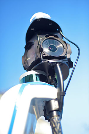
    Handheld mapping. The firm uses the GeoSLAM ZEB-HORIZON handheld mapping device to capture 3D scans of school and church interiors, including small offices, classrooms and closets. The GeoSLAM software generates highly accurate 2D floorplans for use by responders, either hardcopy or digital, to navigate the interior of the building.

    The same data set can also be used to create virtual environments where multiple officers train on computers to respond to attack scenarios in realistic, immersive 3D simulations of actual schools and churches in their jurisdictions.

    “Eventually, we plan to utilize machine learning technology that will allow individual officers of first responder teams to be dispatched to specific locations within the facility in real time to quickly reach shooter engagement locations within the buildings,” Myers said.

    The handheld ZEB-HORIZON laser scanner allows users to map interior and exterior spaces in 3D at walking speed. The lightweight device captures up to 300,000 points per second with an accuracy of 1-3 centimeters up to 100 meters from the user.

    SLAM technology ensures points are tied to local coordinate systems even in interior spaces where GPS/GNSS coverage is poor. Large multi-room buildings that might take days to scan with a stationary scanner can be mapped in a few hours with the ZEB-HORIZON.

    “Mobile laser scanning technology is the fastest and most cost-effective way to create the 2D and 3D building information tools public safety personnel need to prepare for a variety of emergency scenarios,” said Shelley Copsey, GeoSLAM CEO.

    The GeoSLAM Hub software creates a fully integrated data collection and mapping workflow, enabling ZEB-HORIZON users to process, view, merge, edit and output 2D and 3D deliverables within minutes of data capture. Outputs include 2D floorplans, CAD, as well as an integrated workflow for the creation 3D building information models (BIMs).

    Entropy Group is working directly with school districts and places of worship to provide scanning services and develop standardized procedures for the capture of 3D data inside their buildings. These reality capture data sets and derived 2D and 3D products will be provided to local public safety organizations for use in generating hardcopy and digital representations.

  • New Viametris backpack scanner integrates SBG Systems product

    Viametris, specialist of SLAM-based mobile scanning systems, has launched a backpack-based scanning system called the bMS3D-360. The company continues to rely on SBG Systems’ expertise in inertial navigation by integrating the Ellipse2-D, an inertial navigation system with embedded real-time kinematic (RTK) GNSS receiver.

    Photo: Viametris
    Photo: Viametris

    Viametris has been developing SLAM-based scanning systems for more than 10 years, including the iMS3D, a full indoor mapping system and the VMS3D, a car-based mapping system.

    The bMS3D-360 has been designed for the most challenging environments where GNSS is not accessible (indoor) or highly perturbed (urban canyons, forest, etc.). The surveyor starts the system, checks on a tablet that the GNSS and inertial information are computed, and starts the survey.

    Back at the office, the user launches the INS/GNSS post-processing software to increase orientation and position accuracy, and then uses the Viametris software to georeference and colorize the point cloud.

    Collected data are ready to be imported into common design software. This workflow (from collection to plan drawing) is seven times faster than a traditional method.

    The bMS3D-360 offers a 360-degree camera, which greatly simplifies the treatment work. When navigating in the point cloud, the user opens a unique picture of the 360-degree scanned environment instead of looking at four different camera points of view.

    Photo: SBG Systems
    Photo: SBG Systems

    The Ellipse2-D from SBG Systems is a compact inertial navigation system integrating an L1/L2 GNSS receiver. This industrial-grade INS computes roll, pitch and heading as well as position because of its embedded Extended Kalman Filtering.

    In real time, Ellipse2-D orientation data are used to correct the equipment attitude and help the SLAM computed heading. The embedded GNSS receiver provides absolute positioning to the point cloud as well as altitude constraint.

    When the GNSS faces sources of disturbance, the INS maintains the trajectory were the SLAM technology is limited.

  • Viametris mobile backpack scanner includes panoramic camera

    Mobile-scanning company Viametris has launched the bMS3D backpack mobile scanning system, which features an embedded 360° camera.

    Narrow streets and pedestrian zones are considered hurdles when it comes to mobile scanning. The new bMS3D-360 makes these tasks achievable. It is now available on the market and it comes with post-processing software. It will be presented at SPAR 3D 2018 in June.

    “Users of mobile scanning systems know how difficult it is to cover an entire city with this kind of system and how complex the completeness is,” said Jerome Ninot, founder of Viametris.

    Improved Data Exploitation with Panoramic Images. Viametris has found a solution to scanning challenges by developing the bMS3D-360: the mobile scanning backpack system includes a panoramic camera. This sensor allows the user to maintain continuity of results with mobile mapping systems on cars that already include this kind of camera. Operation and visualization with such 360° images are now easy to use.

    Since Google provided massive street views, people are used to navigating through panoramic images. Navigating through bMS3D-360 images becomes easy and intuitive compared to navigating with 3D point clouds, the company said.

    Ten years of experience have allowed Viametris to produce its GNSS mono-antenna system based on GNSS-free scanning (indoor or denied-GNSS area): the system trajectory is calculated by lidar-SLAM. It produces colorized point clouds with absolute accuracy of less than 5 centimeters under appropriate satellite reception conditions.

    Compared to many mobile scanners, this backpack does not rely on GNSS to work. If the GNSS reception is not good enough, control points can be added for absolute localization. The backpack can be used to scan all sorts of indoor areas such as airports, industrial buildings or shopping malls.

    The bMS3D-360 is lightweight. It protects the retractable camera an all other components since it is self-contained.

    Post process in VIAMETRIS PPiMMS Software. PPiMMS post-processing software manages the dataset coming from the system. Its mission is to calculate, control and improve the trajectories by calling lidar-SLAM functions, and reducing drifts, thanks to loop closure algorithms.

    The user can manually add GCPs to constrain the result when GNSS reception is poor. But, in most cases, the user will be able to include post-processed global positions (PPK) using GNSS post-processing software. Additionally, the panoramic camera can be used to colorize the point cloud using PPiMMS.