CalAmp — a provider of wireless products, services and solutions — has launched the MDT-7P Android-based tablet designed to integrate with CalAmp’s family of aftermarket telematics devices.
It features wired, Wi-Fi and Bluetooth connectivity, a rugged 7-inch touchscreen display, and is suited to deliver and support applications for industries such as long-haul trucking, fleet management, asset delivery and mobile workforce management.
“The MDT-7P is designed at its core to support the development and deployment of telematics applications for the mobile workforce,” said Justin Schmid, senior vice president and general manager of the Telematics Systems business at CalAmp. “Seamlessly integrated with CalAmp’s leading telematics devices, the MDT-7P provides a powerful platform to support, monitor and maintain applications such as those designed to support compliance mandates for hours of service, rests, vehicle inspections and other state and federal regulations.”
The MDT-7P leverages CalAmp’s management and maintenance system, PULS (Provisioning/Programming, Update and Logistical System) for autonomous over-the-air installation of applications and firmware directly to the tablet from trusted sources such as CalAmp’s Appstore while in service.
In addition, the CalAmp Mobile Framework (CMF) software provides the interface to CalAmp’s programmable event generator (PEG). PEG enables the MDT-7P to communicate with an installed telematics device to continuously monitor the operating environment and respond instantly to pre-defined and configurable threshold conditions such as time, date, motion, location, geo-zone crossings and other parameters.
The MDT-7P offers a comprehensive and versatile set of features and capabilities including:
Easy-to-use Android Lollipop OS for application development
Support for CalAmp’s Appstore providing a secure environment to manage and distribute applications content and services
High quality built-in front and rear facing cameras to support streaming video applications
Integrated GPS receiver for high precision mapping, navigation, dispatch and routing
Secure 802.11 b/g/n protocols for persistent Wi-Fi connectivity
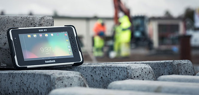
Handheld Group’s new Algiz RT7 tablet is designed for rugged use by mobile workers.
Handheld Group, a manufacturer of rugged mobile computers, today announced the launch of its new Android tablet, the Algiz RT7. The Algiz RT7 is a powerful, lightweight and ergonomic 7-inch tablet designed for reliable performance in demanding environments.
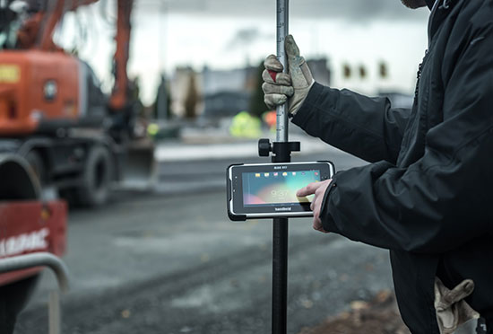
The Algiz RT7, which runs Android 5.1.1 (Lollipop), provides a range of features for mobile workforces, Handheld said. It’s fully rugged, meeting stringent MIL-STD-810G U.S. military standards for protection against drops, vibrations and extreme temperatures, and its IP65 rating means that it’s waterproof as well as fully sealed against sand and dust. Weighing just 650 grams, the Algiz RT7 is designed for mobility.
The Algiz RT7 comes with a built-in accelerometer, gyroscope and e-compass and a stand-alone u-blox EA-7M GPS receiver for navigation, along with built-in Qualcomm IZat location services.
A Qualcomm MSM8916 (Snapdragon) chipset and 1.2 GHz quad-core processor power the tablet, giving it processing speed, ultra-fast connectivity and long battery life. It comes standard with LTE data and voice capabilities as well as 802.11 b/g/n WLAN, BT Class 1 and Class 2, and NFC functionality. It also has dual cameras (8-megapixel rear-facing and 2-megapixel front-facing), as well as dual SIM-card slots.
Designed for the mobile worker, the Algiz RT7 sports a high-brightness 7-inch outdoor-viewable capacitive display that can handle true outdoor challenges. Battery performance is key for any mobile application, and the Algiz RT7 comes with a long-life 3.7V 6000mAh lithium-ion battery. Four programmable buttons allow users to launch and use applications in the field. To enhance data capture, users can choose an optional 2D imager or RFID plus 2D imager.
“Our new Algiz RT7 offers enterprises an exceptional value and is a highly requested product from both our end users and our extensive partner network,” said Jerker Hellström, Handheld Group CEO. “This ultra-rugged tablet delivers best-in-class performance to assist fieldworkers in their daily tasks. The Algiz RT7 is built for tough environments and delivers a streamlined Android experience with power and features appropriate for market demands.”
The Algiz RT7 can be ordered immediately. Shipping will start in December, with volume deliveries starting January 2016.
From our July issue comes this showcase featuring products for surveyors, geographic information systems (GIS) professionals, field workers, and anyone who is looking to expand the capabilities of their smartphone or tablet.
Dedicated Survey/Geospatial
Three-Accuracy Series
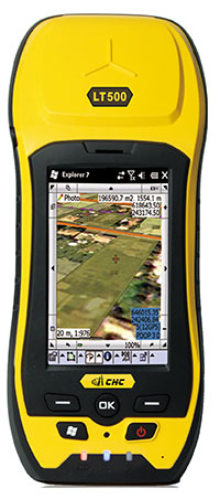
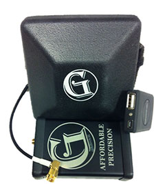
The LT500 series of handheld GPS receivers, LT500H/T/N, covers three accuracy ranges from sub-meter to centimeter. It is a cost-effective full GNSS positioning solution for survey, construction and GIS professionals.
Powered by the Windows Embedded Handheld 6.5 operating system, the LT500 is accurate, rugged and versatile. User productivity is enhanced with the built-in gyroscope, an innovative laser plummet for positioning the accurate handheld receiver over a point, an E-compass for showing the direction and G-sensors for leveling. The LT500 series comes bundled with software including SurvCE, DigiTerra and MapCloud. The LT500H has120 channels (GPS L1/L2/L2C, GLONASS G1, G2, BeiDou B1 and Galileo E1), the LT500T has 220 channels (L1, G1, B1), and the LT500N has 12 channels (L1).
The all-in-one TRIUMPH-LS by JAVAD GNSS combines a high-performance 864-channel GNSS receiver, all-frequency GNSS antenna, and a modern featured handheld. The 864 all-in-view channels include Galileo E1/E5A/E5B, GPS L1/L2/L5, GLONASS L1/L2/L3, QZSS L1/L2/L5, BeiDou B1/B2 and SBAS L1/L5.
More than 100 channels are dedicated to continuous interference monitoring, allowing safe GNSS operation in a city, airport and military environment.
The GEOmeter MX system is designed to gather GIS information in heavily wooded areas, with object description, area coordinates and measurement time grasped automatically. The system consists of the GEOsat MXbox receiver, a combination antenna, a PDA such as the Trimble Recon or the Handheld Nautiz X8, and GEOfield software for mobile GIS.
The Mxbox receiver is a Hemisphere multi-constellation GNSS OEM board with GPS, GLONASS, BeiDou, Galileo and QZSS, plus code- and carrier-phase tracking for increased positioning accuracy and availability. The GEOfield software offers reliabe recording, representation and processing of geodata. Measurement quality is indicated in the field with statistics and graphics, in either German or English.
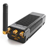
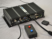
The Matchstiq S10 is a software-defined radio (SDR) platform. It provides increased RF flexibility, RF performance and signal processing capacity in a small package. The Matchstiq S10 platform combines the Epiq Solutions’ Sidekiq SDR with a quad-core processor system running Linux. The Sidekiq MiniPCIe SDR card provides an independently tunable RF transmitter and receiver covering 70 Mhz to 6 Ghz with an RF bandwidth up to 50 Mhz, plus FPGA. The Matchstiq S10 platform also integrates GPS, Gigabit ethernet (with PoE), USB 2.0 OTG, HDMI and real-time clock in a very small form factor package.
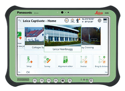
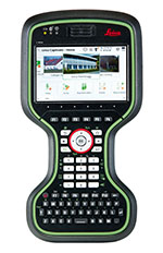
Leica Captivate software provides a 3D view for the Leica Viva GNSS, merging the overlay of measured points, 3D models and point clouds into a single view.
Using Leica Captivate, users can capture and manage complex data with the touchscreen on both the Leica CS20 handheld controller and the CS35 tablet.
The CS20 runs on Windows EC7 and is IP68 and MIL-STD-810F rated. It has a 5-inch WVGA color touchscreen that allows for comfortable and quick data processing and a fully integrated radio and antenna for long range robotic total station control. The CS35’s 10.1-inch screen is visible in all conditions. It runs on Windows 8.1 Pro, enabling workers to take their office into the field. It is IP65 and MIL-STD-810G rated.
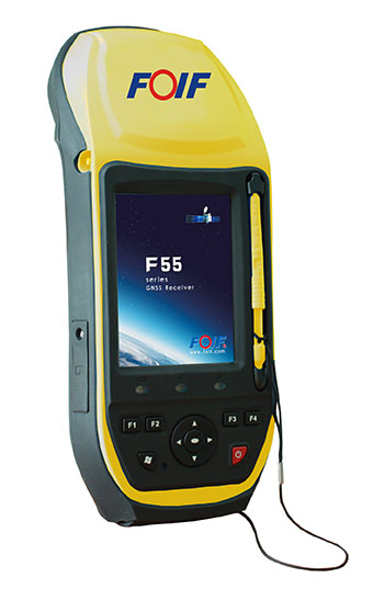
The FOIF F55 series GIS handheld comes in two models: F55-A and F55-B. The onboard software FOIF SuperGiS allows users to conduct field mapping with powerful functions for data collecting, data editing and data querying.
The F55 measures 234 x 99 x 56 mm and weighs 895 grams. It has an IP65 rating for water and dust protection. The F55-A supports four GNSS (GPS, GLONASS, Galileo and Beidou) as well as SBAS, and can search for up to 120 channels. The F55-B supports GPS and SBAS and provides 12 channels.
With Differential GPS, the F55-A has an accuracy of 0.4 meters, and the F55-B has an accuracy of 0.5 meters. RTK surveying on the F55-A obtains high precision of 1 cm + 1 ppm. Real-time correction service and post-processing are available.
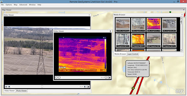
The geoDVR Gen2 is an advanced multi-channel high-definition/standard-definition geospatial digital video recorder designed for aerial and mobile environments.
Unlike a DVR, the rugged geoDVR permanently embeds videos with important GPS location, time and other data — the GPS metadata remains intact even when a video is edited. Most video cameras and gyro-stabilized gimbals can be connected to the geoDVR for recording of HD or geospatial video files.
Video files created by the geoDVR can be analyzed in the RemoteGeo LineVision suite of mapping applications, including tools for Google Earth, Esri ArcGIS, PLS-CADD and the LineVision Cloud. The administrative dashboard allows for monitoring up to four video streams in real-time.
The G1-m1 receiver is part of the G1 family of products from Geomatics USA. The G1 system is scalable from a single-frequency semi-mobile receiver — for control networks and some semi-kinematic mapping applications — to a dual-frequency network RTK solution. It was designed to be lightweight, accurate and portable, especially suited to building a system for travel; for example, all the G1-m1 components, including tripod, will easily pack into a baseball-style bag for transport. The G1-m1 offers centimeter and sub-foot accuracy (centimeter-level accuracy is possible for OPUS-compliant static sessions).
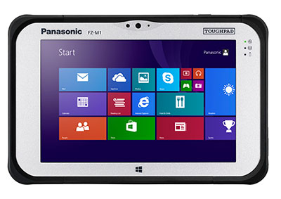
The Panasonic Toughpad FZ-M1 is a thin, light and rugged 7-inch Windows tablet with dedicated GPS — the u-blox Neo M8 series — as an option. The FZ-M1 is built to enable mission-critical mobile worker productivity. Powered by Windows 8.1 Pro and a choice of two Intel processors, it features a long life, user-replaceable battery and a daylight-readable, high-sensitivity multi touchscreen for use with heavy gloves. With a broad range of configuration options, the customizable Toughpad FZ-M1 is rated MIL-STD-810G and IP65, resistant to five-foot drops, weather, dust and water.
Trimble’s RTX technology-based correction services — Trimble CenterPoint RTX, Trimble RangePoint RTX and the new Trimble ViewPoint RTX — are now available on Trimble Geo 7X handhelds.
Trimble RTX technology provides compatible GNSS receivers with correction services that significantly improve accuracy and reliability in obtaining positions worldwide. Operational efficiency and productivity in the field is improved by delivering real-time DGNSS corrections directly to the Trimble Geo 7X handheld.
The handheld solution is designed for industries such as utility companies, municipalities and environmental management agencies, in which workers are highly mobile and require a reliable, flexible data-collection and asset management solution.
A choice of RTX correction services ranging from 4 centimeters to submeter-level horizontal accuracies is available.
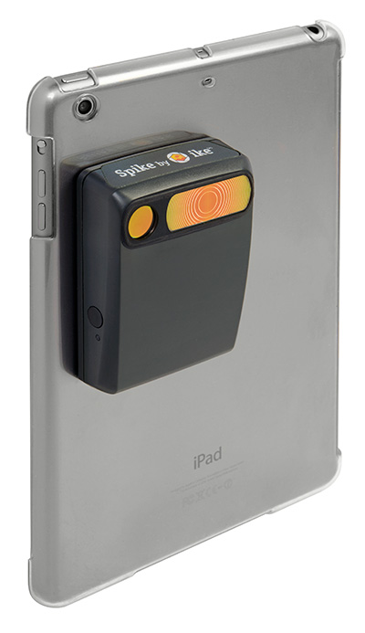
The Spike device and Spike mobile app allow users to measure an object by capturing a photo from a smartphone or tablet. From the photo, users can capture real-time measurements, including height, width, area, length and target location. Location data includes latitude, longitude and altitude. Spike is useful for construction, inspection, safety, advertising, real estate, insurance and government applications.
Measurements and location data are saved with the picture and can be shared via email as a PDF, XML and KMZ. KMZ files can be imported into GIS tools such as ArcGIS and Google Earth. The photo can be referenced via the Spike app to take new measurements or view original measurements.
The Spike device pairs with an Android or Apple iOS smartphone or tablet via Bluetooth. Its laser rangefinder works with a smartphone’s camera, GPS, compass and Internet connection.
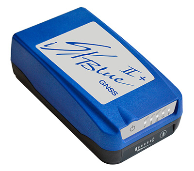
The iSXBlue II+ GNSS is a palm-sized receiver that delivers real-time, high-accuracy performance using GPS+GLONASS satellites and free SBAS corrections for an iPad or iPhone. Its battery-powered lightweight design is for a variety of mapping applications including GIS, forestry, mining, utilities, agriculture, surveying and environmental. It delivers high accuracy in real time without the need for post-processing or another correction source when SBAS (WAAS, EGNOS, MSAS or GAGAN) are available. Using both GPS and GLONASS satellites, the iSXBlue II+ GNSS will work where GPS receivers struggle, such as in the forest, around buildings and in other difficult mapping environments. The L1/G1, GPS+GLONASS receiver has 372 channels.
TerraGo Edge allows organizations to collect data and share field information on their smartphones and tablets. TerraGo Edge replaces traditional GPS handheld devices with a mobile cloud-based solution. Users can collect GPS data points at any accuracy level, either by using the onboard GPS on a smartphone or by attaching a centimeter-level GPS receiver to a mobile device.
TerraGo Edge 3.6 features enhanced support for high-accuracy GPS receivers such as EOS and SXBlue on both iOS and Android, as well as better mapping features, basemap sources and integration with Google Earth.
For managers, TerraGo Edge provides a real-time dashboard for monitoring field users and data collection.
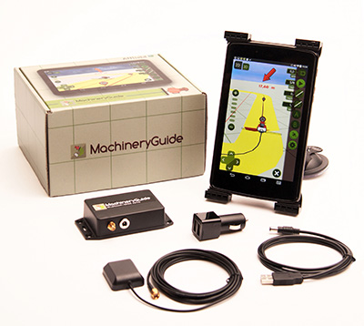
MachineryGuide enables a tablet or smartphone to be used as a precision tractor GPS system. The MachineryGuide Android guidance program functions as a precision farming application using an antenna capable of receiving and processing EGNOS and WAAS corrections. It can be used for any farming activity that is done by tractor or other agricultural machinery, including fertilization, manure application and spraying. It even can be used for land measurements.
MachineryGuide sells the software separately; a GNSS receiver + antenna separately; and a package bundle that includes software, GNSS receiver and antenna. The receiver uses GPS, GLONASS, SBAS and QZSS signals for a position accuracy of 2.5 meters CEP.
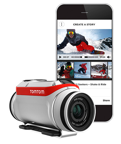
The TomTom Bandit Action Camera allows creation of videos within moments of the action. It comes with a built-in media server, eliminating the need to download footage before editing. The camera works with a companion app, making it possible to create and share videos in a matter of minutes — by shaking a smartphone.
The TomTom Bandit Action Camera is equipped with in-camera motion and GPS sensors to automatically find and tag footage based on speed, altitude, G-force, acceleration and heart rate. Highlights can also be tagged manually with a tagging button on the camera or the remote control.
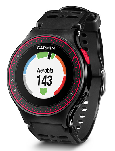
The Forerunner 225 integrates optical heart-rate technology by Mio and features a colorful graphic interface showing runners their zone and beats per minute at a glance. A built-in accelerometer provides distance and pace data for indoor running with no need for a separate foot pod. To keep runners active between workouts, it doubles as an activity tracker, counting steps, calories and distance.
When paired with a compatible smartphone, the Forerunner 225 will automatically upload a completed run to the Garmin Connect Mobile app for post-run analysis and sharing on social media sites. Runners can also use live tracking to allow friends and family to follow along during training or on race day to see stats in real time.
Fleetmatics Group PLC, a global provider of mobile workforce solutions for service-based businesses of all sizes delivered as software-as-a-service (SaaS), has entered into a master subscription services agreement with DIRECTV to enhance tracking, driver safety and on-time arrivals for its fleet of vehicles that are making service calls.
Fleetmatics says its REVEAL is a powerful yet simple-to-use fleet management solution designed to drive cost savings and improve productivity for mobile workforces. Fleetmatics REVEAL+ enables enterprise customers with larger fleets, such as DIRECTV, to manage complex organizational structures and large numbers of users, as well as to deliver actionable executive level business intelligence across the entire enterprise.
“Fleetmatics’ advanced tracking system offers the ideal mobile workforce solution for DIRECTV’s field-based operations,” said David Baker, senior vice president of Field Services for DIRECTV. “This partnership will help our business operate more efficiently while continuing to deliver on our promise of industry-leading customer service.”
“With more than 6,200 new subscriptions, we look forward to delivering actionable business intelligence to DIRECTV,” said Jill Ward, president and CEO of Fleetmatics. “By arming thousands of DIRECTV vehicles with the most powerful telematics solution for the enterprise, we’re helping the company drive cost efficiencies and increase field service worker productivity.”
DIRECTV is a provider of digital television entertainment services to more than 39 million customers in the U.S. and Latin America.
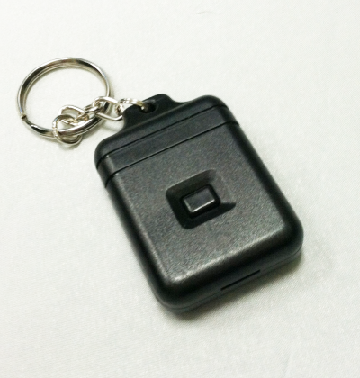
The Instant Alert Device enables drivers to immediately notify dispatch. Photo: GPSTrackIt
GPSTrackIt has developed an Instant Alert Device that can attach to a driver’s keyring, to enable mobile workforce team members to communicate with their dispatchers or fleet managers. If a driver is in trouble, help can be on the way with the touch of a button.
The compact communication device enables drivers to signal for help even if they’re not with the vehicle. Dispatchers are alerted that a driver is in trouble, and can provide vehicle location information to first responders for expedited assistance.
“The device works in a similar fashion to an electronic key,” explains Eddie Bermudez, GPSTrackIt product manager. “It’s a small plastic box with a single button on it. The driver can carry it on his or her keychain. So even if they’re not with the vehicle they can still call for assistance.”
When the button on the device is depressed, it sends a signal wirelessly to a receiver connected to the tracking device in the vehicle. The Instant Alert Device has a range of up to 500 feet.
Bermudez offered an example. “Let’s say you dispatch someone to a remote oil field and there is no cellular communication out there. The tracking device uses both GPS and satellite communications, a combination that provides optimum coverage. The worker can use the Instant Alert Device to notify their team members back at the office if something is wrong or to acknowledge the completion of a task. This gives real-time, up-to-the-minute notifications to the alert contacts via Fleet Manager.”
The feature can be used with any type of switch, button or Power Take Off (PTO) that connects to an input wire on the tracking device.
LOCiMOBILE, Inc., a wholly owned subsidiary of GTX Corp, has launched its first enterprise app for companies looking to effectively track and monitor their workforce in real time. Track My Work Force (“TMWF”) is available for download on iTunes, and based on its early success, is in development for release on the Android platform.
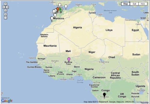
Once downloaded on either an iPhone or iPad, the app works in the background and reports the whereabouts of that device back to the GTX Corp monitoring back-end. The app was designed for small- to medium-sized companies that have a mobile sales or service workforce and need to know the location of their reps in real time. Companies in the U.S., Canada, Czech Republic and Morocco, in industries including transportation, construction, plumbing, IT, medical and pharmaceutical, have already deployed the TMWF app and the GTX back-end monitoring platform.
In January, a pharmaceutical company based out of Morocco that services 25,000 pharmacies across several North African countries deployed TMWF for 150 of its sales reps.
“Our diamond delivery business relies heavily on our traveling sales representatives in order to maintain relations with existing customers as well as meeting new ones. GTX Corp’s Track My Work Force app was extensively tested during our system trial,” Jack Daynes of the Diamond Group said. “The results were such that we implemented the program immediately and haven’t regretted it in the slightest. Both the pricing and the service that we’ve received have exceeded our expectations.”
Companies can easily deploy this technology by leveraging the mass adoption of smartphones and tablets in the workforce, said GTX Corp. In January, a pharmaceutical company based out of Morocco that services 25,000 pharmacies across several North African countries deployed the app for 150 of its sales reps.
“We are very pleased with the initial feedback and potential of this app,” said Patrick Bertagna, GTX Corp CEO. “There are tens of thousands of companies all over the world that can benefit and increase customer service, productivity and security from two-way GPS technology and are now able to implement this technology with a simple download.”
The TMWF app is an efficient and cost-effective way for business owners and managers to keep track of and manage their mobile work force, GTX Corp said. It’s faster and safer than text messaging and allows the worker to focus on the task at hand rather than spending valuable time calling HQ to check in and report, the company said. The app costs $9.99 initially, with an additional monthly monitoring service fee that costs around $5.00 per user per month.
The company provides a free two-week evaluation for any business with more than five employees, and custom solutions along with a licensable white-label platform for larger companies.
 applications such as those designed to support compliance mandates for hours of service, rests, vehicle inspections and other state and federal regulations.”