Space Tech Expo Europe will make its return to Bremen, Germany November 15-17. The full agenda has been released, detailing the speakers, sessions and pressing topics that will help to shape the future of a thriving space industry.
Space Tech Expo Europe provides attendees with fundamental knowledge on current industry trends, challenges, and opportunities in unmissable discussions from technical-level experts from across the supply chain. The expo boasts over 100 speakers, over 450 exhibitors and three separate conferences over three days.
Conferences
The Industry Conference at Space Tech Expo Europe provides audiences with critical insights into the latest updates and key trends happening in the European (and beyond) space sector, aiming to help shape the future of our thriving industry.
Sessions taking place at the Industry Conference will shed light on the sector’s most pressing matters, including industry developments, investment, space exploration, launch, digitalization, the in-space supply chain, space sustainability, and much more.
The Smallsats Conference at Space Tech Expo Europe enables the small satellite community to meet and explore the most exciting developments in the market. Here, the upstream small satellite technology providers, downstream service providers and end-users come together to address the sector’s biggest trends. Topics will include launch and propulsion, increasing satellite manufacturing capabilities, standardization, exploring downstream applications of remote sensing data, creating actionable data insights, and space cyber security.
The Mobility Connectivity Conference at Space Tech Expo Europe bridges the gap between merchant shipping, cruise shipping and commercial aviation’s connectivity requirements, and the technical solutions satellite operators, service providers and ground network providers can now offer through a developing and maturing space and ground technology infrastructure.
Topics include passenger expectations following the pandemic, crew welfare optimization through advanced communication systems, high-data transfer in remote areas, optimized terminals and antennas, hybrid network solutions and advanced onboard communication technology.
TomTom and SWARCO have entered a strategic partnership to enable customers to improve their mobility-management operations by using floating car data-based traffic services to complement physical sensor hardware already installed in the field.
The high-quality traffic services from TomTom, generated from millions of anonymously collected GPS data from apps, cars and devices, are now integrated and available for public entities via SWARCO’s urban mobility management suite MyCity. This data source will enable SWARCO to offer a high-value enhancement to the traffic information it already provides to its customers.
Benefits to MyCity customers include:
real-time travel times for user-defined routes
historical reports on travel time to enable data-driven decision making and impact analysis
triggering strategies based on real-time floating car data to automatically adjust signal plans, reroute traffic or take other traffic management actions
filling potential blind spots between existing roadside sensors to get a complete picture of the traffic situation.
The strategic partnership between SWARCO and TomTom also includes a joint thought leadership program to educate the market further, regular alignments about new features and product updates, and intensified collaboration on funded research projects.
Experts from both companies are available to take city officials, traffic managers, consultants and partners on a test drive of the newly available solutions as well as offer free trials.
Registration for AUVSI XPONENTIAL 2022 is now open. The conference will be held April 25-28 at the Orange County Convention Center in Orlando, Florida.
The XPONENTIAL 2022 theme is “Autonomy Meets Society.” The conference will include keynotes, educational sessions, specialized workshops, and an XPO Hall with 650+ exhibits.
Sessions will feature concentrated presentations, panel discussions, and audience questions to help drive deeper conversations and solutions to some of the industry’s greatest hurdles.
Session themes include:
Convergence Zone: Intersection w/ Businesses
Critical Point: Intersection with Government
DRONERESPONDERS Public Safety Forum
FULL JOIN: Intersection with Data
Interchange: Intersection with Industries
Nexus of Future Mobility: Intersection with Individuals
Proving Grounds: Enterprise + Government Solutions
Technology Crossing: Intersection with Design
Collaborative workshops will provide XPONENTIAL attendees an in-depth look into targeted topics and the solutions needed to harness the full potential of uncrewed technologies now and into the future.
Workshops include:
Orange you Glad Florida is Investing in Autonomy?
Robotics for Conservation
Translating Sustainability
Assured Autonomy Through Safety Performance Monitoring
The Safety Target
Connectedness: How Federal-State-Local Governments are Conquering Implementation Challenges Together
Accelerating Innovation Through Diversity of Thought
DoD Agile Acquisition Workshop – INVITATION ONLY
To view the XPONENTIAL 2022 schedule and exhibitors list and register for the event, visit XPONENTIAL’s website.
Movement, closeness, privacy — many things we took for granted a few months ago have become luxuries after the onset of COVID-19. To get an understanding of the scale and impact of the virus, we can look at global movement trends of people and merchandise using GNSS technology.
Marine
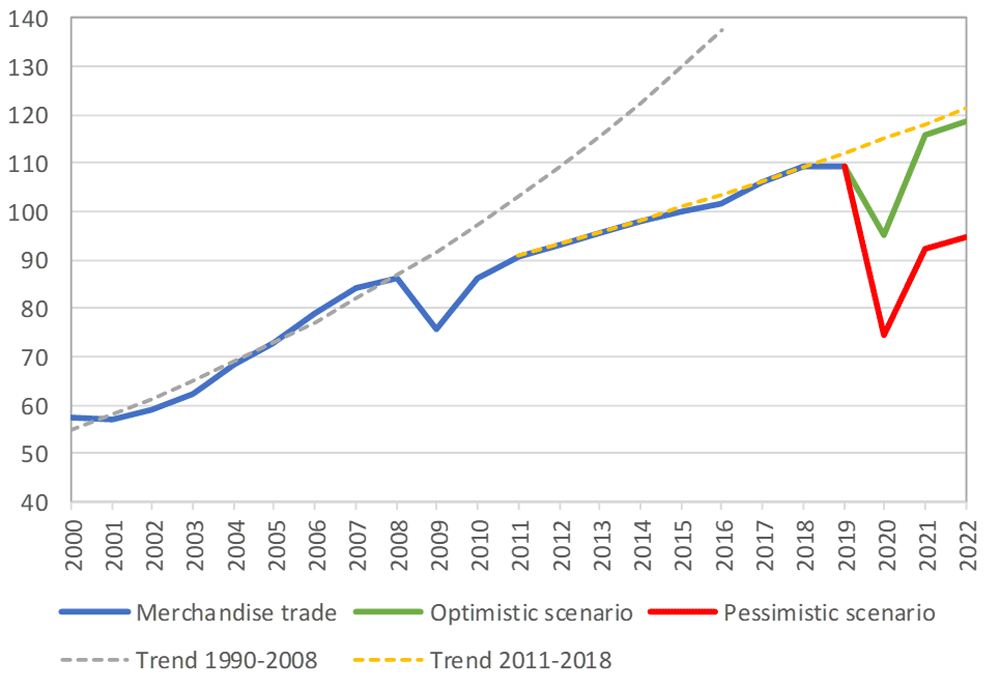
Before the coronavirus pandemic, globalization seemed to be increasing endlessly. Now, we face new trade restrictions, protectionist policies, and a global economic downturn that threatens to stunt growth for years to come.
In April, the World Trade Organization (WTO) forecast that global trade would fall by between 13% and 32% in 2020, surpassing the “great trade collapse” of 2009 spurred by the global financial crisis.
However, the situation isn’t completely bleak. According to a recent Tradeshift report, global trade decreased by 14.8% in the second quarter of 2020, putting us on the optimistic end of the WTO estimate. June saw a rise in trade activity, suggesting that we may be recovering from the initial effects of the pandemic.
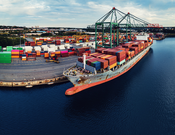
Cargo vessels, tankers, tugs, and other kinds of commercial ships are equipped with satellite navigation devices that can receive information from GNSS satellites to compute precise location and time. Maritime tracking insights obtained via GNSS/GPS signals are a great method for measuring the impact of the coronavirus on trade.
Photo: shaunl/E+/Getty Images
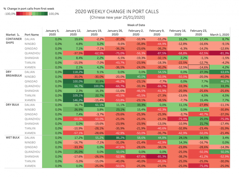
GPS data from MarineTraffic shows that ship arrivals decreased in nearly all of China’s ports from January to March.
Source: MarineTraffic
Just as trade shipping began to pick up in China, the United States and Europe were hit hard by the pandemic. However, shipments have now begun to climb worldwide to compensate for cancellations earlier this year.
The cruise industry, on the other hand, shows little indication of recovery. Cruises were the fastest growing segment of the travel industry over the past five years — until the pandemic hit.
On June 19, the Cruise Line International Association (CLIA) and Centers for Disease Control and Prevention (CDC) announced a “no sail order” for cruise ships. The order has been extended through Sept. 30. Furthermore, the cruise industry’s reputation has been damaged by multiple outbreaks on ships, most recently the MS Roald Amundsen of Norway. At least 43 people were infected on the MS Roald Amundsen, and Norway has now banned cruise ships with more than 100 passengers from disembarking at Norwegian ports.
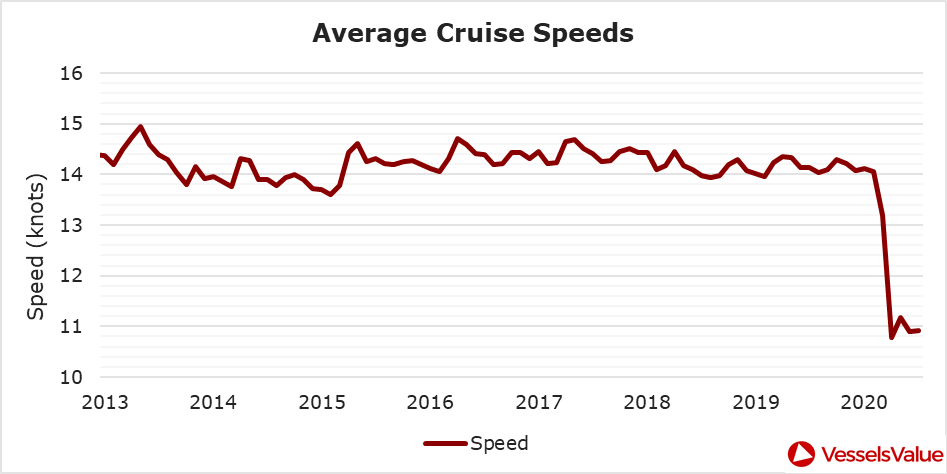
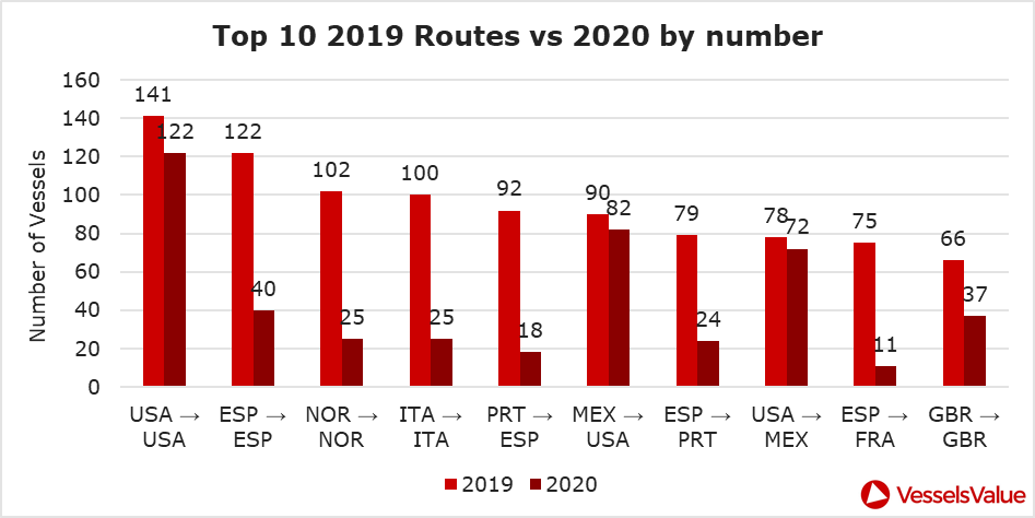
Maritime intelligence company VesselsValue is using AIS data to map cruise ship activity throughout the pandemic. They have noted that while cruise ships typically sail at 13.5 knots to 15 knots, average speed has dropped to 11 knots in 2020 as ships attempt to lower fuel costs. Port-to-port sailings have declined for the 10 most popular cruise routes.
Source: VesselsValueSource: VesselsValue
Most of the port-to-port sailings that constitute the 2020 columns in the above graph actually represent ships being repositioned for a break in service, also called a “layup.” Layups can cost cruise companies millions of dollars per month, but with no sail orders and port closures, they are a necessary expense.
According to the Oxford COVID-19 Government Response Tracker, a real-time monitoring system that evaluates government policies, April marked the strictest lockdown measures across all 133 available coastal countries. The tracker uses a stringency index between 0 and 100 based on national containment and closure policies.
Source: Oxford COVID-19 Government Response Tracker
Air
Commercial air traffic has decreased as well. According to GPS flight tracking service Flightradar24, the number of global daily flights was slashed by nearly two thirds between March and April. While there were 15,012 flights in the air at 15:00 UTC on March 7, there were only 5,275 at the same time on April 7.
Global air traffic March 7, 2020. (Source: Flightradar24)Global air traffic April 7, 2020. (Source: Flightradar24)
There were 55% fewer flights in the last week of March 2020 than in the last week of March 2019. While all types of air traffic have been reduced for fears of infection, the coronavirus has especially decimated demand for passenger flights. Passenger airlines across the world have canceled flights and cut capacity for the foreseeable future. Some passenger airlines have even switched to transporting cargo in a desperate attempt to avoid bankruptcy.
Looking at regional tracking data can further illuminate the impact of COVID-19 on air travel. Travel restrictions and border closures were enacted en masse in late March, though some nations adopted more stringent policies than others.
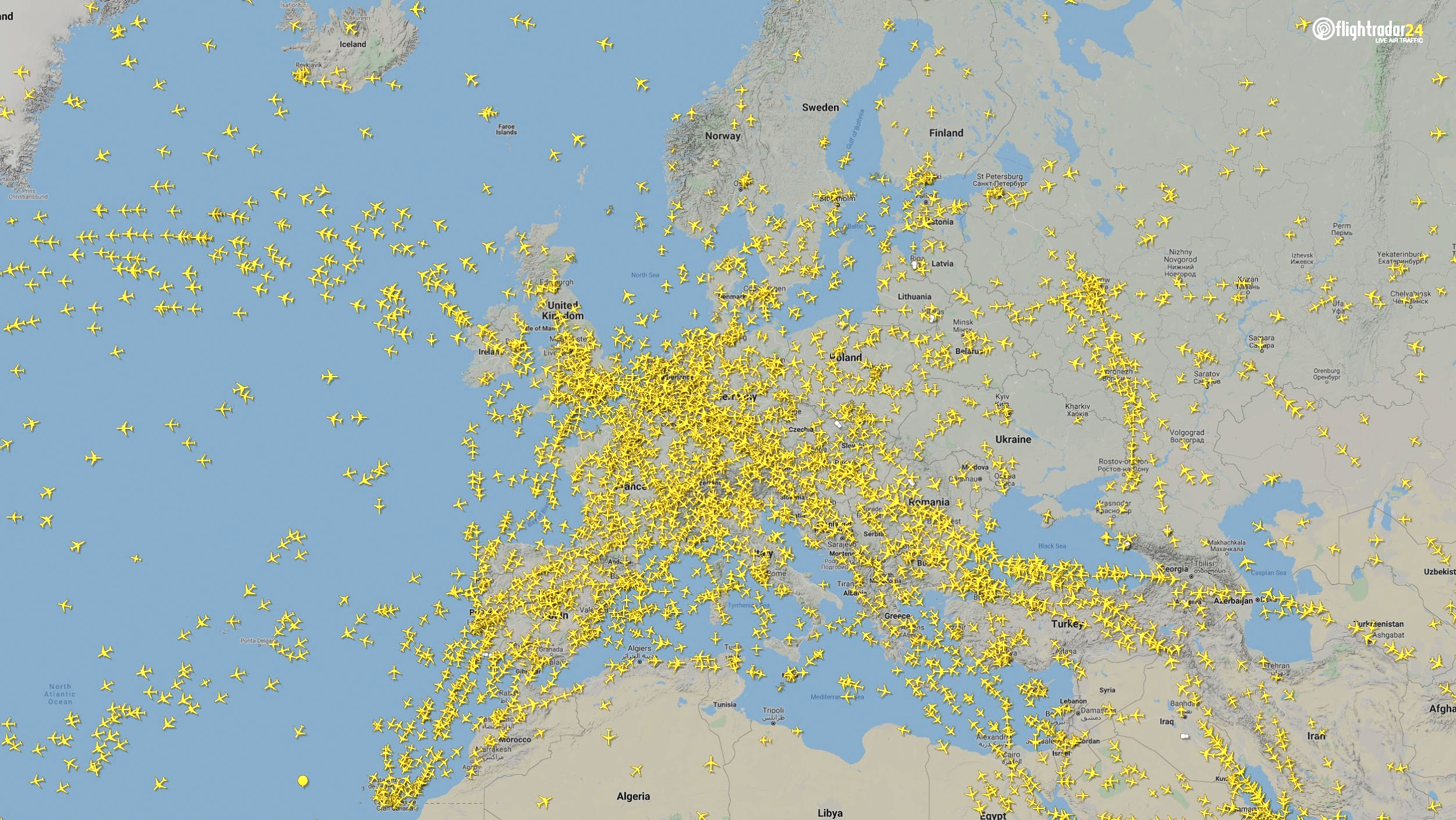
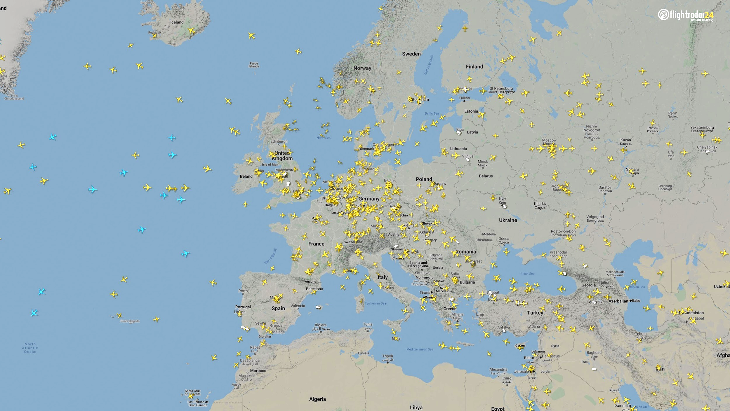
Europe
The number of flights in Europe has plummeted since the onset of the coronavirus pandemic. There were 2,400 fewer flights in Europe on April 7 than March 7.
Air traffic over Europe March 7, 2020. (Source: Flightradar24)Air traffic over Europe April 7, 2020. (Source: Flightradar24)
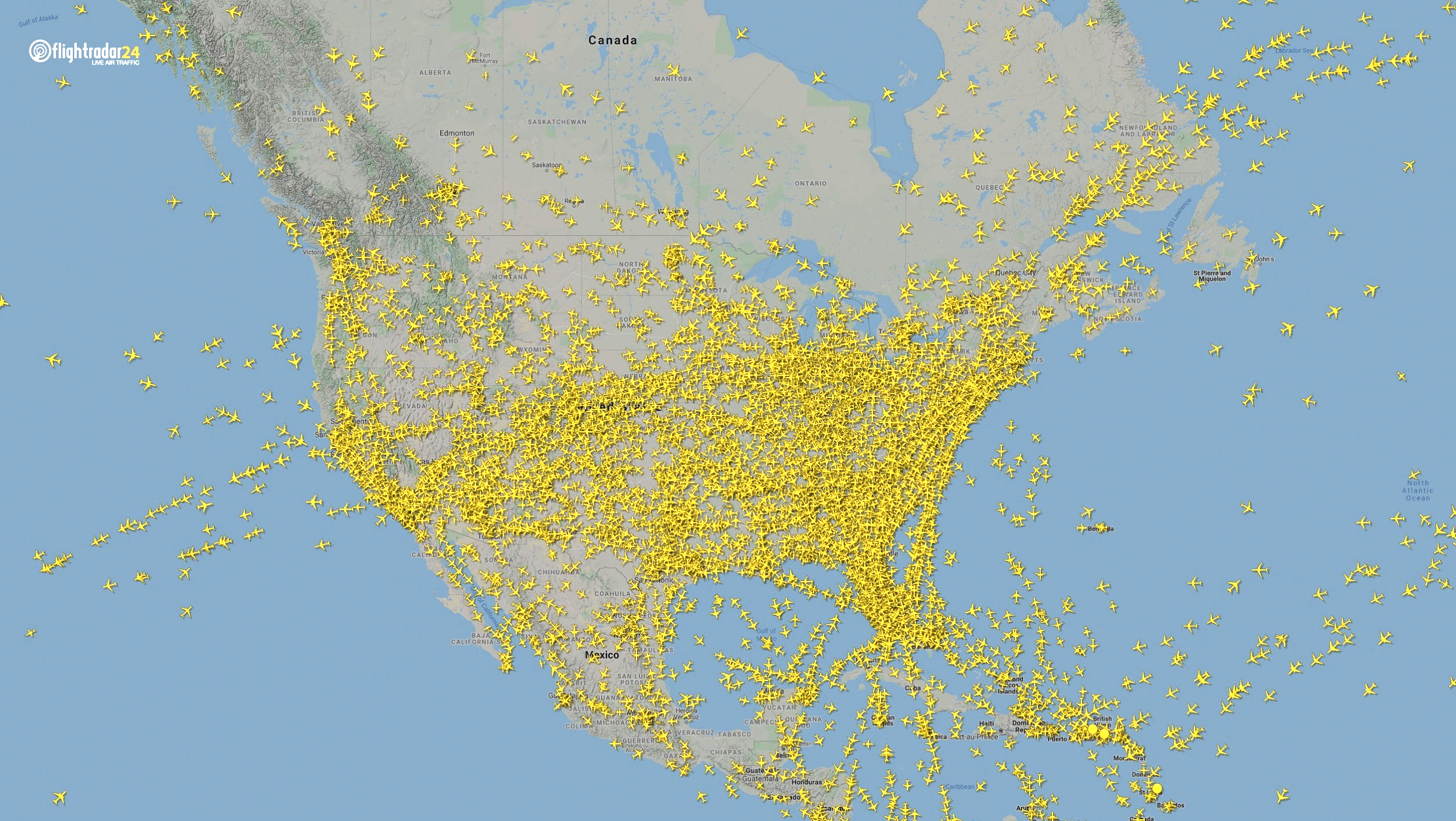
North America
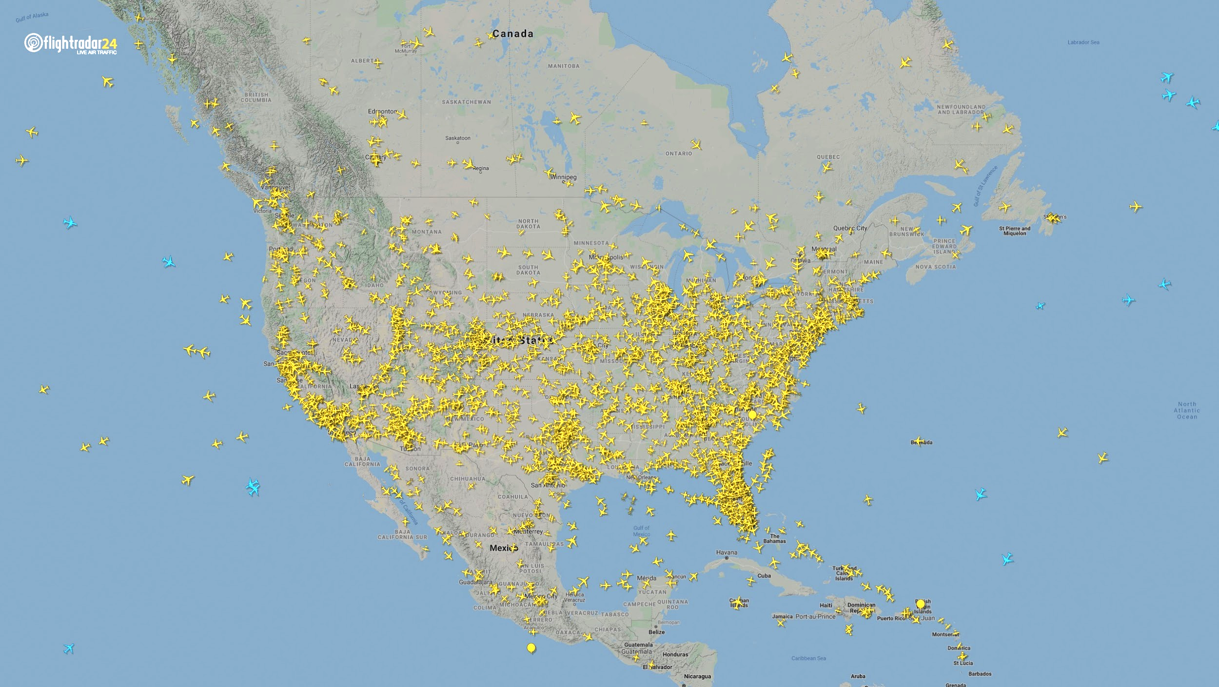
Though air travel has been disrupted across North America, the United States remains significantly more busy than its neighbors. The March 7 image shows 8,400 flights while the April 7 image shows 2,950 flights, most of them concentrated over the United States.
Air traffic over North America March 7, 2020. (Source: Flightradar24)Air traffic over North America April 7, 2020. (Source: Flightradar24)
East Asia
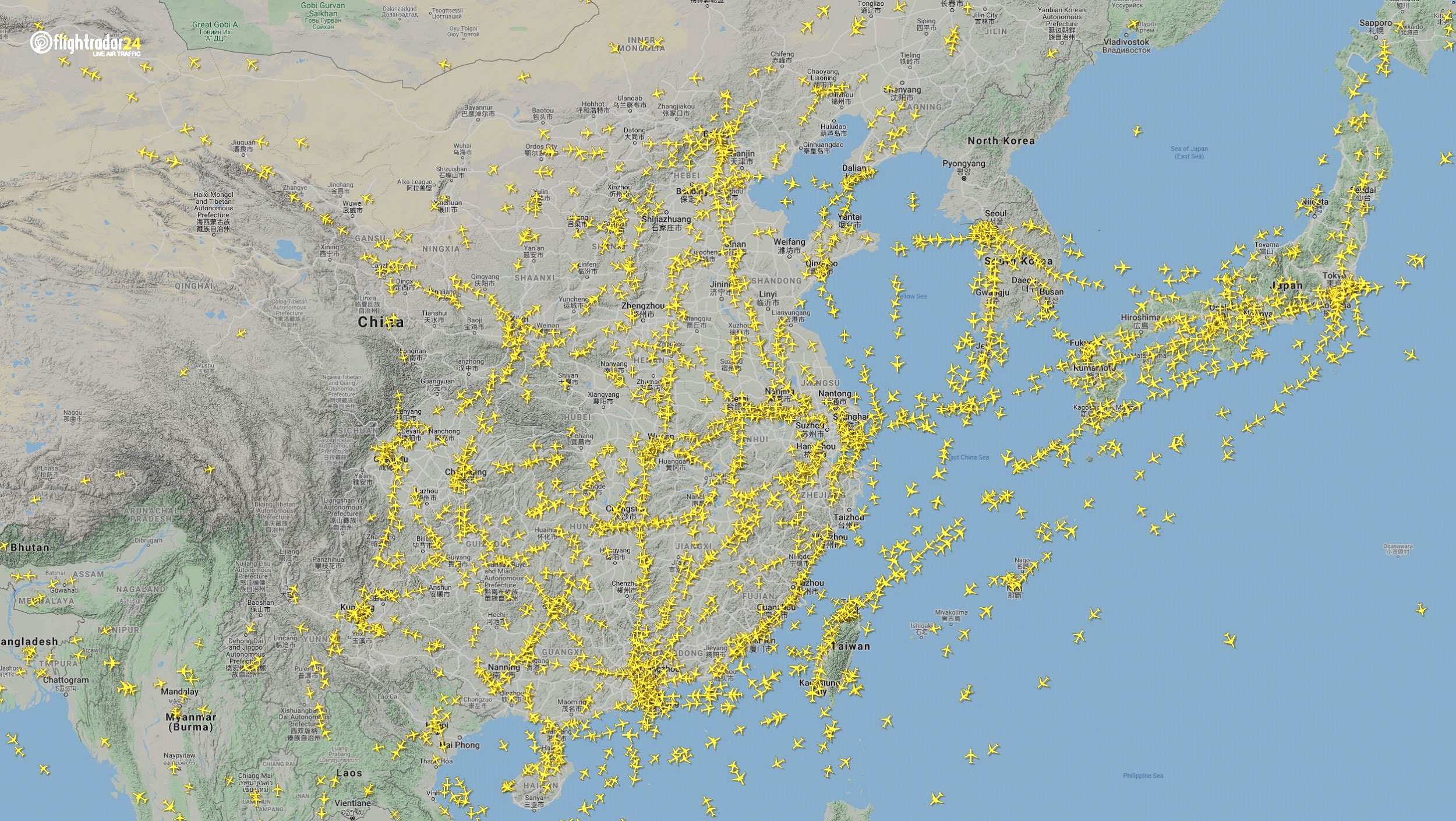
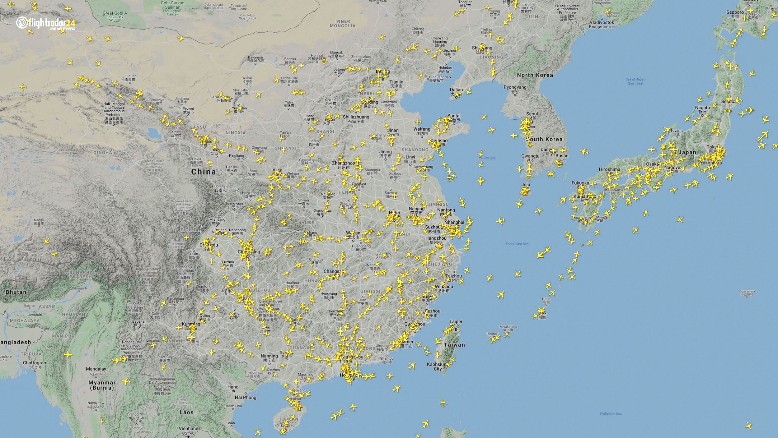
The decrease in air traffic over East Asia has been severe and persistent. Since China and its neighbors began to experience a trade downturn as early as the third week of January, we can compare January 7 to April 7 to capture the effects of the coronavirus. As of late July, air traffic at China’s busiest airports was still down approximately 60% from normal levels.
Air traffic over East Asia January 7. (Source: Flightradar24)Air traffic over East Asia April 7. (Source: Flightradar24)
Ground
Google has released — and continues to update — a series of community mobility reports that chart movement trends in public spaces. The reports are a compilation of GPS data for Google users across the world.
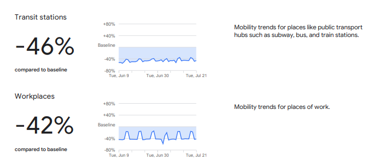
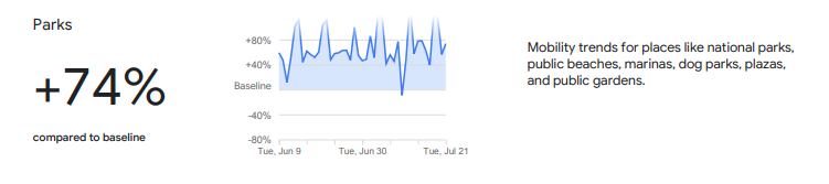
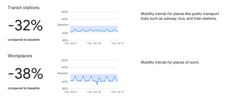
Mobility changes are particularly stark for regions hit hard by the coronavirus. New York state showed a 46% reduction in visits to transit stations and a 42% reduction in visits to workplaces in June and July compared to pre-pandemic baseline levels. New Yorkers are also visiting parks 74% more often.
Screenshot: GoogleScreenshot: Google
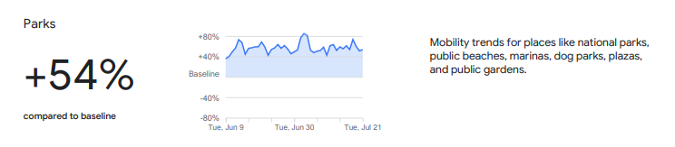
Trends in the United States as a whole are also dramatic.
Screenshot: GoogleScreenshot: Google
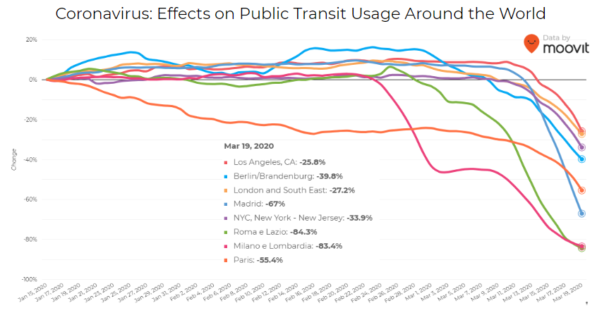
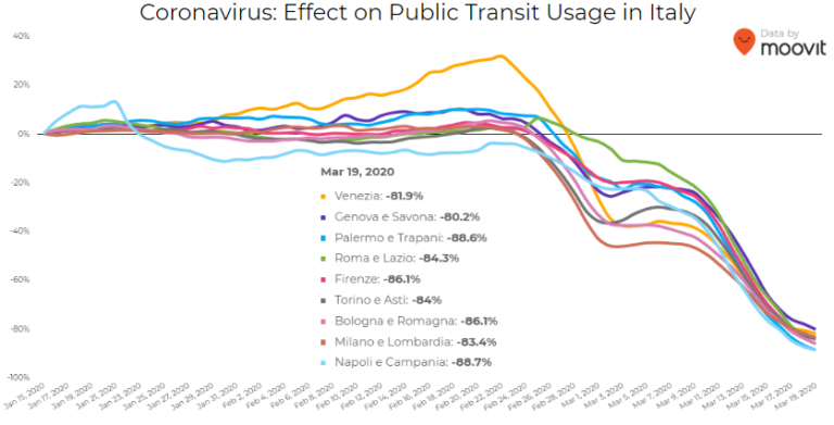
Israeli journey-planning app Moovit is using mobile phone data to document trends in public transit ridership. Many of the world’s largest metropolitan cities experienced a steep decline in ridership between mid-January and late March. Millions of people that rely on mass transit have had to cope with cumbersome rules and the danger of catching the virus itself. Efforts to reduce overcrowding on trains and buses have translated into reduced capacity requirements and therefore, lengthy wait times. The rise of remote work has also lowered public transit ridership.
Screenshot: Moovit
Italy was hit particularly hard – and early – by the pandemic. Two large outbreaks occurred in Northern Italy in late February, prompting widespread closures and government-mandated quarantines in Lombardy and 14 neighboring provinces. Public transit ridership plummeted when the quarantine took effect in early March.
Screenshot: Moovit
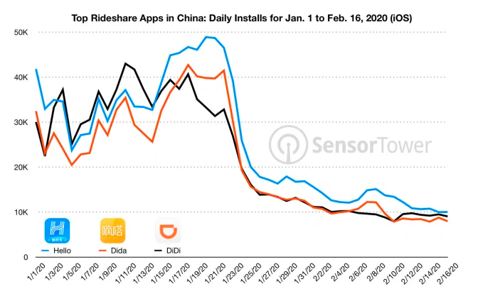
Usage of GPS-reliant ride-hailing apps has also dropped severely. Daily installs of China’s three biggest ride-hailing apps were down 75% the week of February 10 compared to the same week in 2019.
Source: Sensor Tower
American ride-hailing giants Uber and Lyft have seen similar losses. However, business for food delivery apps like Uber Eats and Grubhub are on the rise as more people stay home instead of grocery shopping.
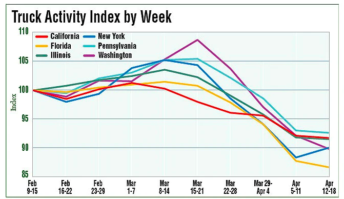
The impacts of COVID-19 have been less severe — but still significant — for the trucking industry. The U.S. trucking industry is an economic powerhouse, typically generating over 700 billion in annual revenue and transporting 72.5% of American freight. The American Transportation Research Institute generated a truck activity index based on GPS data across six states from the week of February 9 to the week of February 12. The data shows an initial spike in trucking operations due to increased demand for consumer goods and medical supplies. However, as stay-at-home orders and restrictions ceased business operations across the country, truck activity declined.
Source: American Transportation Research Institute
Coronavirus safety restrictions adopted by countries across the world have generally begun to loosen up, for better or for worse. It will be interesting to see how the coming months unfold through the lens of GNSS data.
Roi Mitt works for Regulus Cyber, a company researching GPS cybersecurity and offering various software products to protect the integrity, reliability and security of GNSS devices. The company’s products are designed for multiple industries using GPS-based time and location, in order to ensure a future in which GNSS technology is safe and reliable to use.
“Recognizing the importance of driving engagement on future research, development and deployment of automated vehicles, we are confirming that all of the important content already planned for this year’s program will take place within a fully interactive virtual event platform,” organizers said.
The event will feature live sessions and networking, as well as a customizable schedule. In addition, keynote and plenary sessions will explore how society, technology and policy are preparing for and shaping the future of mobility.
TerraGo is exhibiting at Intergeo 2017, which is taking place Sept 26-28 in Berlin, Germany.
“Intergeo brings together the global leaders of the industry and creates an exceptional forum for interpersonal collaboration and the opportunity to show the industry’s only zero-code platform to visitors from nearly 100 countries,” said Stuart Miller, international sales manager at TerraGo. “The event gives us a chance to dialogue and understand our visitors’ goals before we demonstrate our technology. Then by understanding their specific objectives, we can show them how to customize geospatial apps for their unique requirements.”
TerraGo’s GeoPDF products enable free, lightweight GIS applications and have evolved into a de facto standard around the globe, helping organizations get more value — for more users — from their current investments in GIS and imagery platforms, the company said.
Also, TerraGo Magic enables end users without development skills to build custom apps that enable high-accuracy, survey-grade GNSS with advanced GIS and mapping features on Android and iOS devices.
TerraGo’s exhibition will be located at the UK Pavilion, Hall 1.1, Booth D1.016. Click this link to schedule a time for a live demonstration.
CrowdOptic, a maker of crowd-powered mobile applications for live events, and the Location Based Marketing Association (LBMA) have joined forces to develop and promote new focus-aware mobile technology for fans at live events.
Part of LBMA’s mandate is to foster research, innovation and pilot projects that push the boundaries of place-based marketing. Through this initiative, LBMA has partnered with several top-tier global brands carefully selected from among LBMA’s large network of marketing affiliates to introduce the new technology to consumers. The technology will be introduced in a series of test launches at major entertainment events throughout the summer, before making it widely to marketers in the fall, the association said.
Focus awareness combines traditional GPS-location awareness with data on where mobile users are aiming their smartphones. Focus-based technology enables new kinds of apps in which users aim their phones to engage with one another as they watch events simultaneously — for example to connect, chat or vote on the shared subject of focus. Focus-awareness also allows marketers to chart the shifting momentum in crowds.
The partnership comes as demand grows among LBMA’s network for mechanisms to enhance context-awareness in mobile. Marketers want to know how many phones are engaged with their apps as events are happening (heat), who those users are, where they are looking, and how the crowd’s engagement is dynamically changing moment to moment — all capabilities of CrowdOptic’s technology.
“Our vision of the future is new apps that dynamically adapt based on knowing what activities people in a crowd are watching and engaging in, as well as joining people with shared interests together, right there in the moment,” said Asif Khan, founder and president of LBMA.
“Focus is an emerging mobile category that will play a significant role in the next generation of location services,” said Brent Iadarola, Global Research Director of Mobile & Wireless Communications at Frost & Sullivan. “In contrast to augmented reality, which combines location and mobile Internet search to provide information on landmarks in static environments, focus-based services enable the tracking and tagging of objects (or individuals) in moving or dynamic environments. By enabling mobile users to point their phones at moving objects or people to access real-time information about their subject of interest, this area of technology in which CrowdOptic is a pioneer clearly presents some very unique and lucrative avenues for hyper-targeted marketing promotions, advertising, and mobile coupons.”
CrowdOptic is in use around the world in apps that enable users to “aim their phone” to act or interact — whether to discuss, report or discover other people based on their shared focus. The company powers a range of applications which vary from finding friends in a crowd, to aiming a phone to vote, to aiming to alternate views of a live broadcast, to aiming to connect with athletes and celebrities at live events. The technology works both through an app and anytime without an app, by historically mining the standard metadata tags embedded in shared photo images. The mechanisms used to acquire context beyond location include continuous streams of GPS, compass and triangulation algorithms illuminating common points of focus between mobile users.
The LBMA will begin to introduce these projects which leverage the CrowdOptic platform for top global brands beginning in the summer of 2013.
About LBMA – http://thelbma.com/
The Location Based Marketing Association is an international group dedicated to fostering research, education and collaborative innovation at the intersection of people, places, and media. Our goal is simple: To educate, share best practices, establish guidelines for growth and to promote the services of member companies to brands and other content-related providers. The over 600 members of the LBMA include retailers, restaurant chains, agencies, advertisers, media buyers, software and services providers, and wireless companies.